Latrobe Region Nature Guide


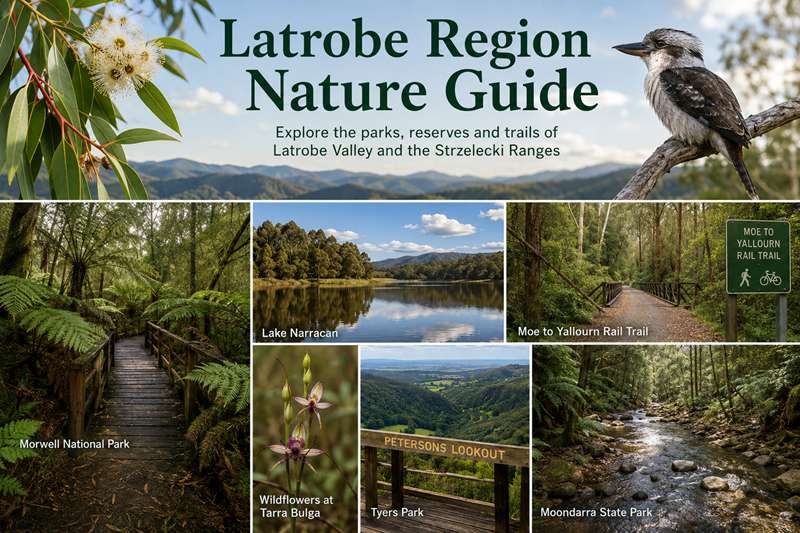
The Latrobe Region in Gippsland, eastern Victoria is an area of dramatic contrasts. It contains one of the largest deposits of brown coal in the world, and major forest industries, yet also provides many and varied opportunities to observe and enjoy native flora and fauna. Some of these opportunities have been enhanced through the cooperative efforts of conservationists, community volunteers, industry, the Department of Natural Resources and Environment and government at all levels, in developing parks and reserves open to the public.
This brochure is designed to assist both visitors and residents to enjoy the diverse wildlife to be found in the Latrobe region. It includes conservation parks and reserves easily accessible in a half day car trip from the central towns of Moe, Morwell and Traralgon in Latrobe City, 150 km east of Melbourne. It covers the region bounded by the foothills of the Baw Baw plateau and the Thomson River to the north, the Strzelecki range to the south, by Mt Worth in the west and Holey Plains in the east.
The regional topography varies considerably from the flat floor of the valley of the Latrobe River, in places less than 20 metres above sea level, through undulating hills to the steeper terrain of the ranges to the north and south.
The Latrobe valley consists mainly of alluvial plains deposited from streams of the Pleistocene era and alluvial fans and high level terraces consisting of gravels, sands, silts and clays from the late Tertiary and recent periods. Flood plains and associated swamps are also important features. The Strzelecki range and the foothills to the north are fault-block ranges consisting of Cretaceous sandstones and mudstones. The Latrobe valley was probably once dominated by open forests and grassy woodlands, with Kangaroo Grass among common understorey species. Remnant stands of eucalypts such as Forest Red Gum, Yarra Gum and Snow Gum remain. The Strzeleckis contain ferny cascading creeks amongst Mountain Ash remnant native forest.
Latrobe Region Nature Guide Map
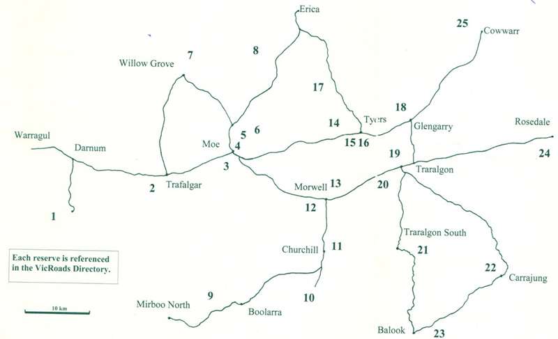
1. Mount Worth State Park
This heavily forested park is in a high rainfall area located south of Darnum and accessible via Darnum-Allambee Rd and Allambee Estate Rd, the latter part being winding & gravelled. An extensive network of tracks lead through magnificent stands of eucalypts such as Mountain Ash and abundant Blackwoods & Silver Wattles and through beautiful moist ferny gullies.
Two popular walks lead to the Standing Giant and along the Moonlight Valley, with relics of early timber milling. Key plant species include Sassafras, Snow Daisy-Bush, Victorian Christmas Bush, Blanket Leaf and Hazel Pomaderris. Lyrebirds are readily heard and other bird species include Whipbird & Lewin's Honeyeater.
The main picnic and toilet facilities are at the park entrance near Moonlight Creek.
2. Uralla Nature Reserve
This forested reserve of 40 ha is on the edge of the town of Trafalgar on Giles Road. There are no facilities, but there is a shady car park which could be a pleasant picnic spot. The main walking track, about 3 km long, was the original bullock track leading to Thorpdale. It heads up a steep hill through stringybark forest, then drops down through shady fern gullies and Mountain Ash before winding around to return to the carpark. There are many bush birds to be seen and in spring there are wildflowers including orchids along the tracks.
The tracks need clearing of debris in some places.
3. Edward Hunter Heritage Bush Reserve
Comprising 57 ha of bushland within the City of Moe, this reserve recognises a Narracan Shire councillor for his dedicated service during the 1940's. Originally a water catchment and storage dam for the early steam trains, today the dam attracts a wide variety of water birds. Although logged and then burnt out during the 1939 fires, it preserves some of the original native bush of the area, with an abundance of orchids in season.
The reserve contains a good network of walking tracks.
Access is from a parking area on Coalville Road.
4. Moe Botanic Gardens
These gardens beside Narracan Creek in the centre of Moe contain both exotic and native trees. Walking paths allow visitors to explore the area and access the Moe-Yallourn Rail Trail.
This pleasant recreation area has car parks, barbeques, picnic facilities and toilets, and is accessed from Narracan Drive which links Moe and Newborough.
5. Moe to Yallourn Rail Trail
The 8 km trail starts at Bennett Street Moe near the Botanical Gardens, crosses Narracan Creek via an attractive bridge and passes through Newborough towards Lake Narracan, which is well worth a detour for a lunch stop. Much of the trail is screened by trees and shrubs which provide habitat for woodland birds such as Red Wattlebirds, Grey Shrike-thrushes and Superb Fairy Wrens. As the trail leaves the town it passes through farmland and provides good views towards the Yallourn W Power Station.
6. Lake Narracan
Constructed in the late 1950's to provide water for the Yallourn Power Station works area, Lake Narracan is now a popular water activities destination in Latrobe City. With a surface area spanning nearly 300 ha, Lake Narracan is popular for bush walking and picnics together with sailing, jet skiing, power boating and sail boarding.
Open grassland, woodlands, low vegetation, lagoons, rushes and reed-beds surrounding the lake attract some 90 species of birds including the conspicuous Yellow-tufted Honeyeater.
Access is via John Field Drive in Newborough. Lake Narracan Committee of Management manages the Reserve on behalf of Latrobe City.
7. Blue Rock Lake
This lake was formed in 1979 when the Tanjil River was dammed at a point 5 km from Willow Grove. Its name originated from an early gold mine operated in the area around 1858. There is a pioneer monument near the dam.
There are three designated picnic areas with toilets, fireplaces and boat launching ramps. Swimming, fishing, non-powered and small powered boats are permitted.
Birds and other fauna are best observed in an area east of the car park at the southern end of Hunts Road. Walk across farm land and follow the water's edge around into the bush. The picnic site off Cerri Road on the eastern side of the lake is also a pleasant observation spot.
The lake is well signposted when entering the township of Willow Grove.
8. Moondarra State Park
Moondarra State Park takes in an area of 6,292 ha of forest on the northern edge of the Latrobe Valley. The Park protects a rich variety of native flora and fauna whilst providing for sightseeing, bushwalking, swimming, and other activities. The Park is accessed from the Moe-Erica Road.
Remains of the old narrow gauge railway line which ran from Moe to Walhalla may be seen in the southern section. The railway was used to service the local timber and mining industries from 1910 to the 1940s. It can be reached via Andersons and Crabhole Tracks off the Moe - Erica Road. Common eucalypts in the Park include Silvertop, Yertchuk, Messmate, Stringybark and Broadleaf Peppermint. The woodland is of an unusual vegetation type, considered to be of state significance. Features include Banksia and Hakea shrubs over a ground layer of spear grass, sedges and lilies. The area is noted for its wildflower displays, particularly along Seninis Track where 16 species of native orchids have been recorded. Nearly 100 bird species have been recorded and echidnas, bandicoots, possums, gliders and a number of reptiles can also be seen.
Camping, barbecue, picnic and toilet facilities are accessed via Seninis Track, and there are basic picnic facilities at the Tyers Bridge.
9. Mirboo North to Boolarra Rail Trail
The trail starts behind the Grand Ridge Brewery & Restaurant at Mirboo North or alternatively from the Boolarra end, at Railway Park near the Old Pub (1884) Café Bar.
From Mirboo North to Boolarra, there is a drop in altitude of 277 metres over the length of this 12.8 km trail. The trail passes through high rainfall country, which had some of the world's tallest trees. Now largely logged, regrowth vegetation of Silver Wattle, Blackwood and Messmate can be seen over the deep cuttings and embankments. About 4.6 km from Mirboo North, the Darlimurla Road runs parallel to the trail on the north side for 1 km to the remains of the Darlimurla Station. A huge Mountain Grey Gum, the ‘Big Tree’, is a few metres along a signposted turnoff about 300 metres to the west of the station remains. The remainder of the trail traverses bush and pasture to Boolarra, providing views of the rolling hills.
10. Morwell National Park
Situated in the northern foothills of the Strzelecki Ranges, this park of 410 ha is of great value in preserving a remnant of the area's original plant and animal life. The park is signposted from the Princes Freeway just east of Morwell, via Churchill, Junction Road and Jumbuk Road.
In the Fosters Gully section a Nature Walk provides an excellent introduction to the natural features of the park. The longer Stringybark Ridge Track leads through a drier section of the park. The Billy Creek walk, a more recent addition to the park, can be started at Jumbuk Road, or from the end of Braniffs Road and leads into a deep enclosed valley dominated by large Manna Gums.
Over 400 recorded plant species include some 40 different orchids, from the tiny bird orchids of autumn to the larger summer flowering Hyacinth Orchid. Nearly 100 species of native birds have been recorded. Greater Gliders and Powerful Owls both frequent Fosters Gully and koalas, wallabies, kangaroos, possums and echidnas are common.
Picnic tables, fireplaces, toilets and information are provided at the Kerry Road Picnic Area, and picnic tables at Lyndons clearing.
11. Mathison Park, Churchill
Mathison Park, of area 38 ha and located within the Churchill township, is being developed as a regional park with a focus on Gippsland indigenous flora but also with representation of Australian and international species. Lake Hyland and its surrounds provide wetland habitat for birds, frogs, reptiles and fish. Over the past twenty years, community volunteers have revegetated a number of areas including the surrounds of Eel Hole Creek.
The most convenient access point is the car park and picnic area on the northern edge of the park, on Mackeys Road, a short distance to the east of its junction with Tramway Road (which links Churchill and Morwell East).
The lakeside Apex Picnic Area on Mackeys Road has a small picnic shelter and toilet. A second picnic area surrounds the ruins of Robert Hare's farmhouse (built in 1920) in the centre of the park.
A formed gravel walking and cycling track forms part of the Eel Hole Creek Recreation Corridor, leading south from the Apex Picnic Area, along the western edge of Lake Hyland to the Kurnai College - Churchill campus on Northways Road.
12. Eric Lubcke Yarra Gum Conservation Reserve
This reserve was created through extensive plantings of Eucalyptus yarraensis, which was common to the area and now classed as becoming rare in Victoria. Extensive coal mining operations south of Morwell destroyed many of these trees. The reserve comprises two blocks, one on either side of Maryvale Crescent. Access is via this Crescent south of the Rose Garden at the western end of the Morwell CBD.
13. Crinigan Road Bushland Reserve
This 39 ha reserve is located near the northern boundary of Morwell's urban area. It is significant as a rare example of the local natural vegetation. The plant list contains some 150 species, from the open forest of Narrow-leaf Peppermint and Manna Gum, through a relatively dense understorey to ferns and a diversity of orchids.
Access is via Maryvale Road, Crinigan Road and Fairway Drive.
Walking tracks radiate from a carpark at the north-east corner.
14. Wirilda Environment Park
This 100 ha bushland park is managed by the Wirilda Project Association and is open from 9 am to dusk. The red box eucalypt association, the riparian vegetation as well as the developing wetland attract the 90 bird species recorded for the Park and provide opportunities for botanising as well as birdwatching. Other activities include swimming, fishing, picnicking and bushwalking. There are two marked walks in the park, which is also the southern starting point of the pleasant day walk from Tyers to Moondarra Dam.
Access is via Clarkes Road which turns north off the Yallourn North/Tyers Road on the west side of the Tyers River. Parking is about 600 metres from the entrance off Clarkes Rd.
Toilets, barbecues, shelter and tables are provided.
15. Garden in a Valley – ‘Dunedin’
This was originally the garden of the noted naturalist and author Jean Galbraith at Tyers, which was purchased and restored by Ollie and Max Archbold.
The garden is open to the public for a small charge on Friday - Sunday except in June and July. Devonshire Teas are served in the restored house which contains displays of Jean Galbraith's life and work.
Access is from Anmans road from Yallourn North to Tyers, just west of the Tyers township and parking is provided in the grounds.
16. Jean Galbraith Memorial Wildflower Reserve
This reserve on land donated by Jean Galbraith is opposite Garden in a Valley on Mt Hope Road in Tyers. A committee of management is working to restore the area to its original flora and provide access paths.
The reserve was the first private wildflower reserve set aside under the auspices of the Native Plant Preservation Society.
There are no facilities at this reserve but there is plenty of picnic space in the township of Tyers.
17. Tyers Park
Tyers Park comprises 1310 ha of forest in the foothills to the north of the Latrobe Valley between Traralgon and Erica. Outcrops of limestone and conglomerate are a feature, the limestone containing both plant and animal fossils. The vegetation is predominantly open forest and woodland, including Yellow Box, Silvertop and Mountain Grey Gum. Birds include honeyeaters and pardalotes, and you may see a Peregrine Falcon overhead. Echidnas, bandicoots and gliders are common.
A walking track follows the Tyers River from Moondarra Reservoir to Wirilda Environment Park (about 5 hours walk). Various access roads to points along the track allow walks on shorter sections. Petersons Lookout is a crag of conglomerate rock which overlooks the Tyers Gorge, providing fine views of the Tyers River and the Latrobe Valley. It is reached via the track marked W2 from the Tyers-Walhalla Road.
There are picnic tables and toilets at Moondarra Reservoir.
18. Gippsland Plains Rail Trail
The Gippsland Plains Rail Trail is 67 km long and stretches between Traralgon and Stratford. The western section from Traralgon to Maffra is well worth exploring for the significant remnant vegetation, especially the Gippsland Plains grasslands. Some of the bridges are unsafe pending restoration, so are best bypassed. A good access point is the restored Glengarry railway station and adjoining park.
19. Victory Park, Traralgon
This city park acquired its name ‘Victory Park’ after WWII. The area was progressively developed to provide mature shade trees and extensive lawns and gardens.
It was later enlarged to incorporate Newman Park on the eastern side of Traralgon Creek as part of an attractive green belt through the town with walking tracks. The nearby Bert Thompson Reserve contains pleasant sheltered picnic facilities with electric barbeques and toilets.
20. Traralgon Railway Reservoir Conservation Reserve
This reserve comprises 29.5 ha of varied bush and grassland situated on the southern edge of Traralgon to the west of Traralgon Creek. A lake in the centre of the reserve is part of the catchment of Traralgon Creek. The Victorian Railways formed the lake in the nineteenth century and supplied water for steam locomotives until the electrification of the Gippsland line. An active Friends of the Reserve group is undertaking programs of revegetation and lake improvement. The reserve contains Grassy Woodlands, notably Forest Red Gum and wetlands. Around one hundred bird species have been recorded.
Access to the reserve is from Hickox Street, Rose Avenue, or Hyde Park Road.
There is a walking path around the lake, a picnic ground, and car park at the Hickox Street entrance. An eroded gully downstream of the lake framed by old eucalypts is a favourite children's playground.
21. Traralgon South Flora and Fauna Reserve
The reserve is about 1000 ha in area and consists of dry sclerophyll forest with a variety of eucalypts with interesting understoreys. Wildflowers are diverse and plentiful in season and birdwatching is rewarding. There are several marked walking tracks ranging up to 9 km. The reserve is accessed from a parking area off the Callignee South Road, Traralgon South about 6 km beyond the Traralgon Creek Road intersection.
Also in the vicinity of Traralgon South is a small Flora Reserve on the eastern side of Traralgon Creek Road, about 10 km from Traralgon.
There are no facilities for visitors at either reserve
22. Jungadale Conservation Reserve
The Jungadale Reserve is located at the junction of the Hyland Hwy and the Grand Ridge Road, at Carrajung, south of Gormandale and approximately 25 km from Traralgon. Vehicle access is possible from the Grand Ridge Rd, about 200 m from the road junction.
This reserve was donated to the community by Australian Paper Plantations in 1998. The block was part of a larger dairy farm from the 1880's. A Green Corps Project Grant enabled the construction of walking tracks during the year 2000.
This 95 ha reserve represents the remnant indigenous vegetation of the Strzelecki Range. Mature regrowth eucalypt species include Southern Blue Gum, Messmate, and Mountain Grey Gum. The reserve contains a deep gully with tributaries, supporting a variety of plant communities. It is home to koalas thought to be one of the few contained populations remaining in Australia. The vehicle access track leads to a small carpark and picnic area with toilet facility. A formed walking track commences at the picnic area and descends steeply into the gully – allow approximately 30 minutes for the 1.9 km circuit.
23. Tarra Bulga National Park
Tarra Bulga National Park preserves magnificent remnants of cool temperate rain forest in the Strzelecki Ranges and is easily accessed from the Grand Ridge Road.
A canopy including ancient myrtle beech trees shelters diverse ferns, fungi, mosses and liverworts and you will frequently hear or even see lyrebirds. A number of walks radiate from the Visitor Information Centre at Balook. One of these tracks features a suspension bridge over a deep gully of magnificent treeferns.
The ridges feature tall stands of Mountain Ash.
In the lower Tarra Valley section a delightful walk through tree ferns leads to Cyathea Falls. Winter visitors should be prepared for cold and wet conditions. Picnic areas, shelters with fireplaces and toilets are provided at Bulga and Tarra. The Visitors Centre in Balook has comprehensive information and displays.
24. Holey Plains State Park
Holey Plains is an area of 10,000 ha of open forest, mainly Saw Banksia and eucalypts, on a series of sandy ridges. The area contains an extremely varied flora, with over 530 species being recorded. This includes some very rare and localized species such as the Holey Plains Mintbush Prostanthera galbraithii, which is almost restricted to the Park. Grass trees are also a feature, together with at least 25 species of orchids. The park contains a network of narrow winding sandy roads and tracks, many of which are driveable and from which emus and grey kangaroos are frequently to be seen. Birds are numerous and varied, especially when the banksias are in flower.
There are picnic areas on the top of Holey Hill (218 m), the highest point in the park, and at Harriers Swamp, Merrimans Creek and Clear Water Lake. All provide fireplaces, and all except Merriman's Creek have toilets.
Camping is permitted at Holey Hill and Harriers Swamp.
Access to the Park is most easily obtained from Rosedale on the Princes Highway, between Traralgon and Sale. Turn south from the centre of Rosedale on Willung Road, cross the railway then follow the signs.
25. Cowwarr Weir
This recreation area surrounds an irrigation weir, and provides swimming, picnicking and fishing opportunities. Large trees provide shady areas, and these together with the surrounding bushland provide good bird watching. The area is also adjacent to forest drives on the northern side of the weir.
Access is off the main Traralgon to Heyfield road between Toongabbie and Cowwarr.
Facilities are excellent with toilets, barbecues.


