Yallourn North - Wirilda Environment Park


Wirilda Environment Park is a State Park located just outside the township of Tyres. The Park offers a bush setting picnic area with toilets, shelter, barbecue facilities and signage to read about the Parks history. One of the main walks from the park leads to Moondarra Dam, traversing 12.5km of steep, formed track.
Highlights include:
- A range of vegetation from mountain to valley, from rainforest to drier areas and from regenerated to untouched bush.
- The lovely Lyrebird, no doubt imitating some of the 90 other bird species here.
- Animals such as Grey Kangaroo, Wombat, Possum and Wallaby.
- Various walking tracks.
- Fragments of local history in Traralgon's first water supply, an old lime kiln and Moondarra grazing run.
- Fossils revealing the prehistory of the area.
- Scenic beauty at Peterson's Lookout and in the Tyers River Gorge.
How to Get There
Wirilda Environment Park is located in Yallourn North, approximately 180km from Melbourne.
From Melbourne head south-east towards Warragul, then take exit towards Moe and Tyers. Travel along Brown Coalmine road and take left turn just before the Tyers River Bridge.
Follow Clarkes Road for a short distance and take a hard right turn onto the Pipeline Track towards the Wirilda Environment Park, which is sign-posted.
You will pass the homestead and Environment Centre, dip down across a wooden bridge and then straight ahead the car park where the Gippsland Water Pumping Station is situated, next to the river and picnic area.
Bushwalking
The Wirilda Track is the Latrobe Valley's best kept secret. The track follows the Tyers river past an old lime quarry and kilns until it crosses on an old pipeline. It winds through open forests and generally follows along the course of the meandering Tyers River through the Boola State Forest and Tyers Regional Park to the Wirilda Environmental Park; sometimes well above and away from the river.
There are numerous spots where you could stop for a picnic, overnight or to fish. The impressive cliffs below Peterson's lookout are a feature. Birdlife, wildlife and wild flowers abound. Keep your eye out for signs of the old pipelines one of which was made of wood!
See the tracks notes for a a 2km return walk (Walking Maps) and a 14km bushwalk (Bushwalking Victoria).
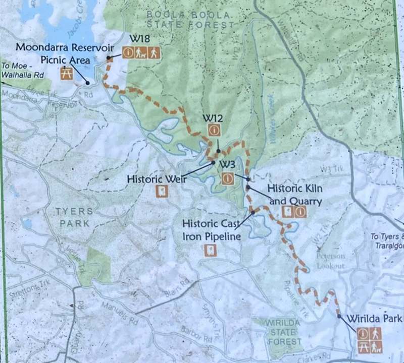
Wirilda Park to W3
One-way 6km, 2 hours, short steep hills, formed track, some obstacles, signposted, occasional steps and some bushwalking experience recommended.
W3 to W12
One-way 2.2km, 1 hour, gentle hills, formed track, some obstacles, signposted, occasional steps and some bushwalking experience recommended.
W12 to W18
One-way 4.3km, 2 hours, very steep, formed track, some obstacles, signposted, occasional steps and some bushwalking experience recommended.
Walk Historical Background
Wirilda Walking Track is 12.5km/6hrs in length, crossing Boola Boola State Forest and Tyers Park. lt offers a challenging day walk with stunning bushland scenery.
The track is normally walked from Moondarra Dam off W18 track and walked down to Wirilda Park in the Latrobe Valley, however multiple roads intersecting the track enable it to be completed in shorter sections.
The open forests of Boola Boola State Forest and Tyers Park are diverse in flora and fauna. The bush comprises a variety of plants including Prickly Stringybark, Silvertop Ash, tea trees, wattles, grasses and over 30 species of orchid. During Spring the bush comes alive with the colour of wildflowers and the song of birds. On warm sunny days keep a look out for Peregrine Falcons as they soar above the gorge and Gippsland Water Dragons basking on the rocks below.
The walk is rich in history. In 1877, the railway was extended from Melbourne to Traralgon which saw the township of Traralgon increase in size. There became a heavy demand to supply water to the growing town, which led to the development of a permanent domestic water supply system.
In 1916 a weir was built on the Tyers river to resolve the water supply problem. The natural wind of the river through the gorge and a short tunnel through a hill created enough fall to start the flow of water which travelled to the township through a gravity fed wooden pipeline system.
In 1919 the original weir wall was replaced with a larger four-foot concrete wall to increase the supply of water as the town continued to grow. The weir can be seen from the track by looking down the cliff to the river, below just south of W12. The wooden pipeline system was replaced in 1921 with cast iron pipes. Remnants of the historic wooden pipes can still be seen in sections of Tyers Park.
Between Wirilda Park and W3 the track crosses Tyers river. The old cast iron pipes are used as a bridge and may require wading through water when the river is high or be impassable after heavy rainfall.
In 1958, Moondarra Dam was built on the Tyers river upstream from the weir and made the weir and pipeline system redundant.
During the 1930s, a lime kiln was in operation. The. products were used locally at the Australian Paper Manufacturers or sent by rail to Melbourne for construction purposes. The remains of the kiln and adjacent quarry can be seen perched on the edge of the cliff south of W3.
Birdwatching
Binoculars in hand, twitchers come from across the world to explore Victoria's vast wilderness, lush wetlands and marine parks. And with more than 400 species of birds to be found, it's easy to see why. So grab your walking boots and hit the trail to see these feathered friends in their native habitat.
There are 37 birds listed for being spotted at Wirilda Environment Park. Here are just some of them: Pacific koel, Horsfield's bronze cuckoo, Superb lyrebird, Satin bowerbird and many more. See the bird guide.
Camping
Sites are unpowered. There are no showers available. There are free barbecues in the park. Camping is $5 per night. One of the committee members will go down on the weekends in the morning to collect the payment and issue a receipt.
Park rules are no fires at any time, please take your rubbish home when you leave, no cutting down trees or saplings and no camping within 10 metres south of the pavilion.
Location
Pipeline Track, Yallourn North 3825 View Map
Web Links
→ wirildaenvironmentpark.org.au/
→ Ollies Track - Wirilda Environment Park (Walking Maps)
→ Wirilda Track (Bushwalking Victoria)


")