Sherbrooke Forest Walks (Sherbrooke)

")
Sherbrooke covers the southern area of the Dandenong Ranges National Park from Selby in the south to Sherbrooke in the north.
This area has magnificent Mountain Ash forests and a number of walks from picnic areas. You may even hear the song or perhaps get a glimpse of the Superb Lyrebird.
The walks include:
From either Sherbrooke and O'Donohue Picnic Grounds (Cnr Sherbrooke Road and Sherbrooke Lodge Rd, Sherbrooke)
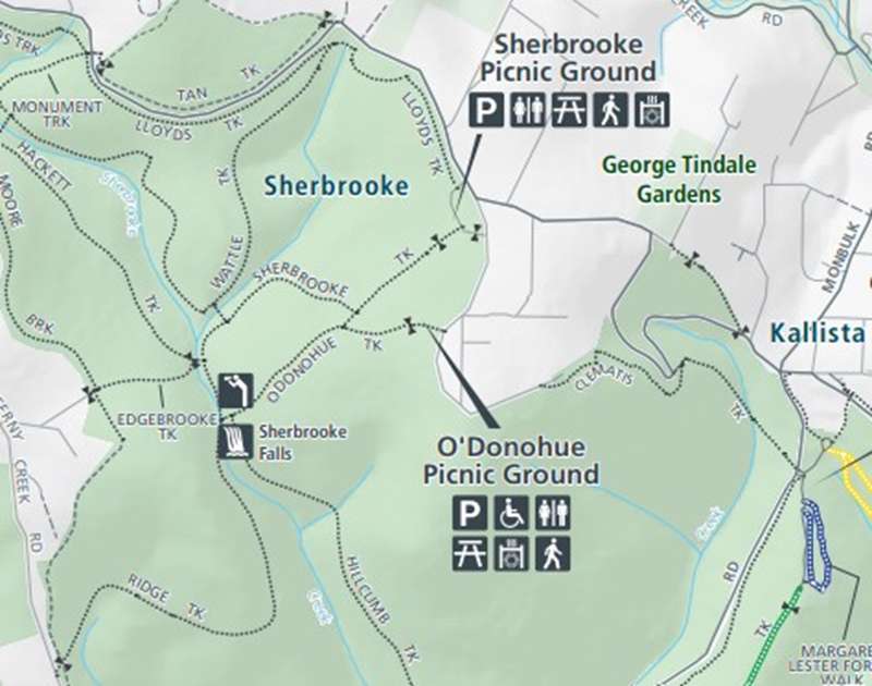
Sherbrooke Falls
This walk is 2.4 km, 1 hour return and is graded easy to moderate. Tracks leading from Sherbrooke and O'Donohue Picnic Ground provide the easiest walk to the falls through the attractive landscape of tall Mountain Ash and tree ferns. The falls are most inspiring after rain when the swollen Sherbrooke Creek rushes over the rocks.
From Grants Picnic Ground
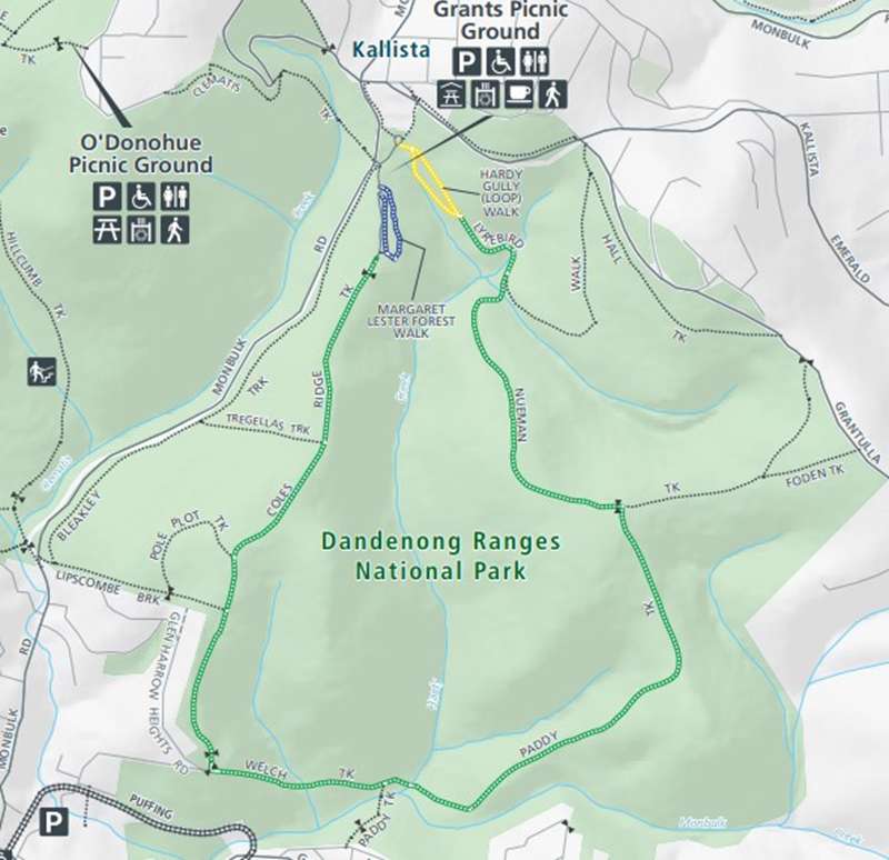
Hardy Gully Nature Walk
This walk is 700m, 45 minute loop and graded easy to moderate. This track, only a short distance from Grants Picnic Ground, has been set out as a self-guided nature walk.
Margaret Lester Forest Walk
This walk is 500m, 30 minute loop and graded easy. Located at Grants Picnic Ground, this hard-surfaced track has been especially designed for the disabled. The track follows a steady gradient weaving through spectacular Mountain Ash forest.
Lyrebird Loop Walk
The 5.4km Lyrebird loop walk is one of the best rainforest walks in the Dandenong Ranges. The track winds through towering Mountain Ash forest and dense tree fern gullies.
Eastern Sherbrooke Forest Walk
This walk is 7.1 km, 2 hour loop and is graded moderate to difficult. This is a round trip starting and finishing at Grants Picnic Ground. The route follows Lyrebird Walk, then Neumann Road, passing though cleared areas of bush created by the successive wildfires of the early 1900's. At Paddy Track Junction turn south and cross Hardy Creek before climbing Welch Track and following Coles Ridge Road back to the picnic ground. Most of the walk is through Mountain Ash and Messmate Stringybark forest. There are steep sections on Paddy Road and Welch Track which may be slippery when wet.
Tregellas Loop Forest Walk
A 2.5km loop through Mountain Ash forest featuring fern gullies, native birdlife and peaceful bush surroundings. The walk follows sections of Coles Ridge Track and Bleakley Track before returning to Grants Picnic Ground. The trail is relatively easy and ideal for families wanting a longer forest walk.
Review:
For the Sherbrooke Falls walk there are two picnic grounds close together. The Sherbrooke Picnic Ground has plenty of tables and BBQs - some with shade. The walk to the Falls is only 1200m and no bike riding is permitted due to the sensitive Lyrebird habitat (and it can be quite boggy in patches also). In the walk to the falls the habitat changes quite a bit and includes tall trees, fairly open areas and rainforest areas. There is a reasonable chance of seeing some colourful parrots. The route is not completely sign-posted but you should be OK if you follow your nose and don't get distracted by the side tracks.
Near the falls the track splits into either Hillclimb Track or Ridge Track (both get you to the falls). Hillclimb Track continues onto Belgrave. There is a wooden bridge over the falls which are not that spectacular.
The other picnic ground, O'Donohue Picnic Ground is open and less integrated into the surrounding bush that the other Picnic Ground. One section has six tables (a couple are shaded), BBQ and water tap. Another partially shaded area has two tables. There is a toilet block here.
Photos:
Location
Cnr Sherbrooke Road and Sherbrooke Lodge Rd, Sherbrooke 3789 View Map
Web Links
→ Dandenong Ranges National Park South - Park Notes
→ Eastern Sherbrooke Forest Circuit (Bushwalking Blog)
→ Sherbrooke Picnic Ground (Parks Victoria)
→ Grants on Sherbrooke Cafe
→ Grants Picnic Ground (Parks Victoria)
→ friendsofsherbrookforest.blogspot.com.au
→ Dandenong Ranges National Park Sherbrooke Map (PDF)
→ The Best Family Activities in the Dandenong Ranges


")