Margaret Lester Forest Walk (Sherbrooke)

Margaret Lester Forest Walk is an easy (suitable for beginners) 500m (30 minute) loop.
This hard surfaced track, constructed in 1981, was the first of its kind in Victoria and enables people with limited mobility the opportunity to enjoy and discover the forest.
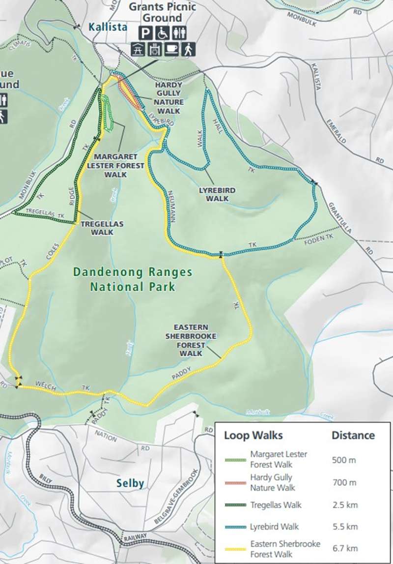
Sherbrooke Forest Grants Picnic Ground Loop Walks Map
Update June 2026: The Margaret Lester walk track currently has rough and uneven surfaces, and is no longer suitable for people with accessibility requirements. Parks Victoria will be undertaking upgrade works in the near future. See this page for updates.
Information along the walk tells a story of the forest environment, history of the Aboriginal people, struggles of early Europeans and important work of early naturalists. There is also signage for the Heidelberg School Artists Trail (Sherbrooke Forest, 1924 by Tom Roberts).
At Grants Picnic Ground there are toilets, many picnic tables and BBQs, large shelter with four tables and water tap. There is also a cafe on site.
Access for Dogs:
Dogs are not permitted at Grants Picnic Ground or on the walks.
Review:
The entrance to the track is on the south-east side of Grants Picnic Ground (near the large shelter with four tables). The tracks passes a nice rainforest type environment.
There is a 1.2m wide asphalt track leading from the Picnic Ground and at the end you can either return along the same path, come back along a gravel path or alternatively along the paved Coles Ridge Track which has car parking spaces along the sides.
There is interesting signage at regular bays along the path which have seating. There are often birds such as sulphur crested cockatoos gathering near the start of the walk.
Information Signs:
A Healing Place
The Dandenongs have always been a significant cultural place for the local Aboriginal people. The Wurundjeri and their sub-clans believed some streams and creeks held special healing properties. Nanbathnia Springs near Monbulk was considered the source of the healing water in the Dandenongs.
Aborigines visited the Dandenongs each summer and collected plants not found on the plains and foothills below. They used many different plants for food, medicine, implements and fibres.
Blackwood Wattle (Acacia melanoxylon) wood was used for spear throwers and shields. The bark was heated and infused in water to bathe rheumatic joints.
Treefern provided a starchy food, and the young fern tips a nourishing vegetable.
Bush Banquet
Aborigines helped the first Europeans explore the Ranges in the early 1840s. Botanist Daniel Bunce described how his companions found food in the bush.
“During the excursion, our diet consisted chiefly of opossum and kangaroo varied occasionally with the flesh of the porcupine (echidna) and wombat. The heart and crown of the treefern, lightly roasted, furnished us an acceptable dish the taste of which reminded me of coconut. Native potatoes or roots of the Orchidacea (orchids) were not wanting. One evening we took three wombats and the next day the natives held a banquet, preceded as a matter of course by a corroboree.”
Timber!
The tallest trees around you are Mountain Ash (Eucalyptus regnans). They are about 65 metres high and most grew after a forest fire in the 1920s.
Mountain Ash is the tallest growing species of flowering plant in the world. Mature Mountain Ash trees can reach to more than 100 metres.
In the 1850s people saw the Dandenongs as a vast, unending forest resource. Early settlers soon discovered that Mountain Ash was a valuable timber. There were several sawmills in Sherbrooke Forest in the early 1900s, including one near Grants picnic ground.
The last trees were felled here in the late 1930s.
Forest, farms or houses?
The area of forest in the Dandenong Ranges has shrunk significantly since it was first reserved in 1867.
Clearing for farming and housing allotments reduced the forested public land to small “islands” centred around Sherbrooke and Olinda Forests and Doongalla Estate.
During the 1890s depression the government offered allotments of Crown Land in the Dandenongs as part of a scheme to reduce poverty in Melbourne. Land developers in the 1920s, knowing the popularity of the area, subdivided the farmlands surrounding the forest.
In 1950 the Government made the first major purchase to buy back land to protect the forest. Over time, purchases linked the islands of public land to create what we now know as Dandenong Ranges National Park.
"Everyone wanted their own slice of the hills."
Free Land Available
Imagine you were a "free selector" in the 1890s, unemployed and poor, looking at your 10 acres (40 house blocks in today's terms) of forest. What would your life in the forest have been like?
Poor Melbourne families could take up a free selection on condition that they lived on it for at least eight months of the year. They had to clear the forest, build a slab hut and grow berries and vegetables for a living. All this with only hand tools and no modern luxuries such as cars, sealed roads, or electricity.
A friend of the lyrebird
Tom Tregellas worked in an iron foundry in Collingwood but escaped on weekends to Sherbrooke Forest. He helped make this forest famous for its lyrebirds and earned an international reputation as an amateur naturalist.
Tom studied, photographed and wrote about lyrebirds to encourage their protection.
His weekend home was a hollow log 5 metres long and 2.5 metres wide. Tom died in 1938 and his log has long since rotted away, but his love of lyrebirds lives on in people today who care for the forest and its wildlife.
The park needs friends
Conservation of the natural environment is a major aim in the management of Dandenong Ranges National Park.
Today the city reaches the park, exposing the forest and its wildlife to urban impacts from cars, domestic animals and garden weeds.
Many conservation groups and individuals assist in protecting this special place by carrying out tasks such as surveying lyrebirds, weeding and revegetation work.
Local residents too are helping protect the Ranges by confining their dogs and cats on their properties, planting indigenous (local) native plants in their gardens and removing environmental weeds from their gardens.
Find out how you can help by contacting park staff.
Location
12 Coles Ridge Track, Sherbrooke 3789 View Map
Web Links
→ www.parks.vic.gov.au/places-to-see/sites/grants-picnic-ground-margaret-lester-forest-walk
→ Margaret Lester Forest Walk (Walking Maps)
→ Dandenong Ranges National Park (Sherbrooke Area) Loop Walk Map
→ www.parks.vic.gov.au/places-to-see/sites/grants-picnic-ground


")