Lyrebird Loop Walk (Sherbrooke)



.jpg "Lyrebird Loop Walk (Sherbrooke)")
Lyrebird Loop Walk is a 5.6km walk through the Sherbrooke Forest with towering Mountain Ash trees in a small pocket of cool temperate rainforest.
The Superb Lyrebird Menura novaehollandiae is often seen in the forest scratching through the deep leaf litter to feed on worms, spiders and grubs. The male has the ability to mimic the sounds of other birds and activities that it hears – for example Puffing Billy’s whistle. Like a DJ, it arranges these sounds into melodious songs that can be heard throughout the forest in the winter months when they are intent on attracting females.
-embed01.jpg)
Start at the trail gate opposite the bus car park at the northern end of Grants Picnic Ground and follow the Lyrebird track. At the end, turn right onto Hall Track and follow it until the track intersects with Neumann Track (vehicle track). Turn right onto Neumann Track and follow it all the way until it reaches Lyrebird Track. Turn left on Lyrebird Track and follow it back to where you commenced at Grants Picnic Ground.
At Grants Picnic Ground there are toilets, many picnic tables and BBQs, large shelter with four tables and water tap. There is also a cafe on site. You will often see cockatoos and rosellas in this area but note that feeding is prohibited.
-embed04.jpg)

Interactive map
Access for Dogs:
Dogs are not permitted at Grants Picnic Ground or on the walks.
Review:
This is one of the iconic walks in the Dandenong Ranges and is probably the best of the loop walks starting at the Grants Picnic Ground.
The first part of the walk heads downhill past the entrance to the 700m Hardy Gully Nature Walk. Look out for a giant Mountain Ash tree which was struck by lightning and is now completely hollow. This part of the walk is a beautiful combination of tree ferns and mountain ash trees.
Along the track see will come across an intersection with Neumann Track which is the return loop on this walk. Continue straight ahead on Lyrebird Track through an area which is very mossy and has lots of tree ferns. This area is one of the better areas to find fungi during the winter months although we didn't see as much fungi as we expected.
-embed02.jpg)
The track intersects Hall Track (close to Grantulla Road) and heads south. This area has more towering mountain ash and less tree ferns. You then head west along Neuman Track which passes Brendon's Corner which is a large grassy clearing where people have built some substantial cubbies made from tree branches.
-embed03.jpg)
You will reach an intersection of tracks and a sign which states 2km back to Grants Picnic Ground via Neumann Track or 4.6km back to Grants Picnic Ground via Paddy Track. The route via Paddy Track is part of the 7.1km Eastern Sherbrooke Forest Walk. Go around the gate back to the picnic ground via Neumann Track. This track heads downhill and was the muddiest part of the walk. On the way we saw a wallaby.
Sherbrooke Forest Grants Picnic Ground Loop Walks
Starting from Grants Picnic Ground in the heart of Sherbrooke Forest, you can choose from several beautiful walks through towering Mountain Ash forest, lush tree fern gullies and one of the best places near Melbourne to spot Superb Lyrebirds. Whether you're after a short stroll or a longer adventure, there's a walk to suit every visitor.
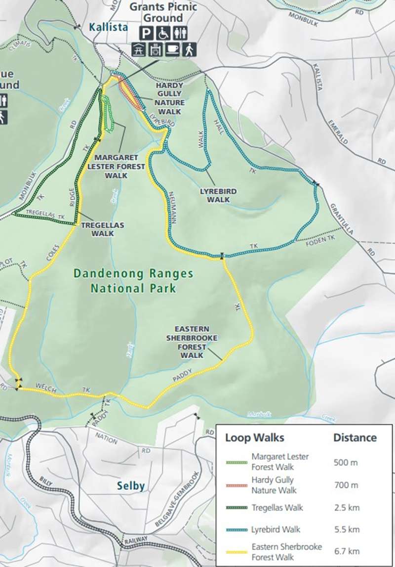
The walks are:
- Lyrebird Loop Walk – 5.6 km loop, about 2 hours (Moderate)
One of the finest walks in the Dandenong Ranges, this scenic circuit follows Lyrebird Track, Hall Track and Neumann Track through the heart of Sherbrooke Forest. The chances of seeing lyrebirds, wallabies and colourful native birds are excellent.
- Hardy Gully Nature Walk – 700 m loop, 30–45 minutes (Easy)
Wander beneath towering Mountain Ash and giant tree ferns through a cool, mossy gully. This is one of the best short walks for spotting Superb Lyrebirds, particularly early in the morning or late in the afternoon.
- Margaret Lester Forest Walk – 500 m return, 15–20 minutes (Easy)
A gentle walk through magnificent rainforest featuring interpretive signs about the forest ecosystem. Originally designed as an accessible trail, it remains a great introduction to Sherbrooke Forest, although the surface is currently uneven in places.
- Tregellas Loop Walk – 2.5 km loop, about 45 minutes (Easy)
A peaceful circuit through fern-filled gullies and towering eucalypt forest with one moderate uphill section. Ideal for visitors wanting a longer walk without tackling steep terrain.
- Eastern Sherbrooke Forest Walk – 7.1 km loop, 2.5–3 hours (Moderate)
The longest marked walk from Grants Picnic Ground, exploring quieter sections of the national park. Expect magnificent Mountain Ash forest, towering tree ferns, peaceful gullies and abundant birdlife away from the busier picnic area.
Photos:
Location
12 Coles Ridge Track, Sherbrooke 3789 View Map
Web Links
→ Lyrebird Loop Nature Walk (Walking Maps)
→ Dandenong Ranges National Park (Sherbrooke Area) Loop Walk Map
→ www.parks.vic.gov.au/places-to-see/sites/grants-picnic-ground


