Gold Diversion Tunnels in Victoria


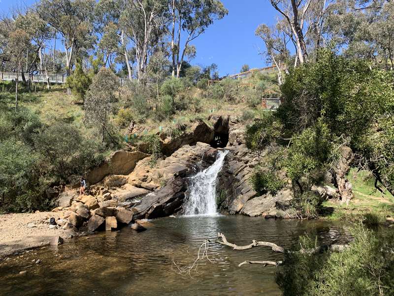
During Victoria's gold rush, miners faced an enormous challenge. Valuable gold deposits lay beneath the beds of rivers and creeks, but flowing water made these deposits difficult to reach.
One ingenious solution was to divert the water around a bend in the river. Miners excavated tunnels through rocky spurs or cut channels across narrow sections of land, redirecting the water and exposing sections of the original riverbed for gold mining.
Many of these remarkable engineering works survive today. Some still carry flowing rivers, while others remain as historic tunnels, diversion channels and abandoned waterways.
Several are accessible via short walks or scenic bushwalking tracks, while others are hidden deep within Victoria's remote goldfields.
This guide explores some of Victoria's most fascinating surviving gold diversion tunnels and channels, from easily accessible family attractions to remote historic mining sites.
Gold Diversion Tunnels Accessible by Short Walks
These historic tunnels are among the easiest to visit, with established visitor areas or relatively short walking tracks.
Melbourne and the Yarra Valley
Pound Bend Tunnel (Warrandyte)

Perhaps the most famous river diversion tunnel in Victoria, the Pound Bend Tunnel, also known as the Evelyn Tunnel, was completed in 1870 to divert the Yarra River.
Stretching approximately 145 metres through a rocky ridge, the tunnel was constructed to expose approximately 5 km of the original river course for gold mining. However, the venture was abandoned after about 12 months because costs were high and gold returns were disappointing.
Today, water continues to flow through the tunnel, which is surrounded by the beautiful bushland of Warrandyte State Park.
River/Creek: Yarra River
Nearest Town: Warrandyte
Access: Park at Pound Bend Reserve and follow the walking paths to the tunnel viewing area.
Little Peninsula Tunnel (McMahons Creek)

Located on the upper Yarra River, the Little Peninsula Tunnel is a fascinating reminder of the gold rush in the Yarra Valley.
Constructed during the late 1860s, the approximately 30-metre-long tunnel diverted the river through a rocky spur, lowering the water level in the original river channel so miners could recover gold-bearing sediments.
The tunnel is surrounded by attractive riverside scenery and is easily reached from the nearby picnic area.
River/Creek: Yarra River
Nearest Town: McMahons Creek
Access: Park at Little Peninsula Tunnel Picnic Ground, off Warburton-Woods Point Road. Approximately 150 m walk to the tunnel.
Big Peninsula Tunnel (McMahons Creek)
Located approximately 1 km along Warburton-Woods Point Road from Little Peninsula, the Big Peninsula Tunnel is another remarkable example of gold rush engineering.
The tunnel was excavated through solid rock to redirect the Yarra River around a large bend, allowing miners to work the exposed river gravels.
Water continues to flow through the tunnel, and walking tracks lead down towards the river.
River/Creek: Yarra River
Nearest Town: McMahons Creek
Access: Roadside parking off Warburton-Woods Point Road, with walking tracks descending towards the tunnel.
Important: Parks Victoria has permanently closed the Big Peninsula Stepping Stones because of erosion and instability. Visitors must obey the closure and should not attempt to cross the river at this location.
Central Victoria
The Blowhole Gold Diversion Tunnel (Hepburn)
The Blowhole is one of Victoria's most interesting and accessible gold diversion tunnels.
Constructed during the gold rush, probably in the early 1860s, the tunnel redirected Jim Crow Creek through a rocky spur, effectively bypassing approximately 750 metres of the original creek course.
This allowed miners to work the exposed gold-bearing gravels along the abandoned creek bed.
Today, water flows through the historic tunnel and emerges at a picturesque waterfall known as The Blowhole. The site is listed on the Victorian Heritage Register.
River/Creek: Jim Crow Creek
Nearest Town: Hepburn
Access: Park at the end of Blow Hole Road. A short walking track leads to the tunnel and waterfall.
Gold Diversion Tunnels Requiring Bushwalks
These sites offer rewarding opportunities to combine bushwalking with gold rush history. Walking tracks may include steep sections, uneven surfaces and river crossings.
Central Victoria
Lerderderg Diversion Tunnel (Lerderderg State Park)
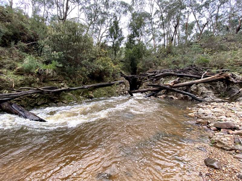
Hidden within the spectacular Lerderderg Gorge, the Lerderderg River Diversion Tunnel is commonly known as The Tunnel.
Excavated during the gold rush, probably between 1855 and 1870, the tunnel was driven through a narrow rocky spur to divert the Lerderderg River away from a horseshoe-shaped bend.
The exposed riverbed could then be worked for alluvial gold.
The walk follows part of the historic Byers Back Track, which traces an old water race along the steep valley. The route eventually descends to the river, where the diversion tunnel can be viewed.
River/Creek: Lerderderg River
Nearest Town: Blackwood
Access: Start at O'Brien's Crossing and follow Byers Back Track to Gribble Track, descending steeply towards the river.
Distance: Approximately 4 km return
Time: Approximately 2 hours
Difficulty: Grade 4 - steep sections, narrow tracks and uneven ground.
A river crossing may be necessary to obtain a clear view of the tunnel. Do not attempt to cross when water levels are high.
Gippsland
Horseshoe Bend Tunnel (Coopers Creek)
The Horseshoe Bend Tunnel, also known as the Thomson River Diversion Tunnel, is one of Victoria's most impressive gold mining engineering works.
Completed in 1912, it was constructed considerably later than most of the state's gold rush diversion tunnels.
The approximately 220-metre-long tunnel was excavated through Stockriders Spur to redirect the Thomson River around a large horseshoe-shaped bend.
This exposed the original riverbed for gold mining, and the tunnel remains an important example of the engineering techniques used by miners in the early twentieth century.
The scenic walking track passes through forest before descending towards the Thomson River, with opportunities to view the tunnel entrances and surrounding river scenery.
River/Creek: Thomson River
Nearest Town: Walhalla
Access: Start at the Horseshoe Bend Tunnel Walk car park, reached via Coopers Creek Road.
Distance: Approximately 4.3 km return
Time: Allow approximately 1.5-2 hours
Difficulty: Moderate, with some steep sections and river crossings.
Delegate River Diversion Tunnel (Bendoc)
The Delegate River Diversion Tunnel is a remarkable example of mining ingenuity in the remote forests of East Gippsland.
Constructed during the nineteenth-century gold rush, the approximately 80-metre-long tunnel was excavated through hard rock to divert the Delegate River away from its original course.
This allowed miners to search for gold in the exposed riverbed.
The tunnel is surrounded by attractive forest and river scenery and can be reached along an established walking track. Picnic facilities are provided near the start of the walk.
River/Creek: Delegate River
Nearest Town: Bendoc
Access: Walking track from the visitor area along Pretty Gully Track.
Distance: Approximately 2.2 km return
Difficulty: Moderate, with occasional steps, short steep hills and limited signage.
Remote Historic Gold Diversion Tunnels
Several other diversion tunnels survive in remote parts of Victoria. These sites are historically important, but public access and suitable walking routes have not been verified.
They are included for their historical interest rather than as recommended family excursions.
Gippsland
Gibbo River Diversion Tunnel (Benambra)
Located in the remote alpine country near Benambra, the Gibbo River Diversion Tunnel was constructed to redirect the river and expose gold-bearing gravels in its original bed.
The tunnel is one of the lesser-known examples of nineteenth-century water diversion engineering in Victoria's mountain goldfields.
River/Creek: Gibbo River
Nearest Town: Benambra
Access: Remote historic mining site. Public access and walking route have not been verified.
Houghton's (McKoy's Flat) Diversion Tunnel (Deptford)
Situated on the Nicholson River in East Gippsland, Houghton's Diversion Tunnel was excavated to redirect river water and expose alluvial gold deposits.
The tunnel forms part of the historic McKoy's Flat mining area near Deptford, where extensive mining activity took place during the nineteenth century.
River/Creek: Nicholson River
Nearest Town: Deptford
Access: Remote historic mining site. Public access and walking route have not been verified.
Victorian High Country
Tunnel Bend Diversion Tunnel (Gaffneys Creek)
Located on the Goulburn River near Gaffneys Creek, the Tunnel Bend Diversion Tunnel was constructed to redirect the river around a bend and expose valuable alluvial gold deposits.
The tunnel is one of several nineteenth-century mining diversions associated with the historic Gaffneys Creek goldfield.
The surrounding district contains numerous remnants of former gold mining operations.
River/Creek: Goulburn River
Nearest Town: Gaffneys Creek
Access: Remote historic mining site. Public access and walking route have not been verified.
This site should not be confused with Tunnel Bend in the Howqua Hills Historic Area, which is a separate location on the Howqua River.
Jericho Tunnel (Jordan River)
The Jericho Tunnel was constructed to divert the Jordan River near the former gold mining settlement of Jericho.
During the nineteenth century, the Jordan River goldfield was an important centre of mining activity, with miners exploiting both alluvial deposits and quartz reefs.
The diversion tunnel survives as a reminder of the engineering works undertaken in this remote mountain district.
River/Creek: Jordan River
Nearest Town: Woods Point
Access: Remote historic mining site. Public access and walking route have not been verified.
New Adventure Diversion Tunnel (Omeo)
Located in the Omeo goldfield, the New Adventure Diversion Tunnel was constructed to redirect a watercourse and expose gold-bearing deposits.
The site is associated with the extensive alluvial mining operations that transformed the Omeo district during the nineteenth century.
Although less well known than other Victorian diversion tunnels, it is recognised as an important historic mining site.
River/Creek: Livingstone Creek
Nearest Town: Omeo
Access: Remote historic mining site. Public access and walking route have not been verified.
Flourbag Creek Diversion Tunnel (Gaffneys Creek)
Another historic diversion tunnel is located near the junction of Flourbag Creek and the Goulburn River.
The tunnel was excavated to divert water and enable miners to work gold-bearing deposits along the original river channel.
Together with nearby Tunnel Bend, it illustrates the extensive engineering undertaken to recover alluvial gold from the Goulburn River.
River/Creek: Goulburn River, near Flourbag Creek
Nearest Town: Gaffneys Creek
Access: Remote historic mining site. Public access and walking route have not been verified.
Historic Gold Diversion Channels
Not all gold mining diversions involved excavating tunnels through rock. In some locations, miners constructed open channels, sometimes called diversion sluices, to redirect water away from productive sections of riverbed.
These works were often substantial engineering projects involving the removal of large quantities of earth, stone and gravel.
Gippsland and the High Country
Harrison's Cut Diversion Sluice (Dargo)
Harrison's Cut is a historic diversion channel constructed beside the Dargo River.
Miners excavated the channel to redirect flowing water away from a section of riverbed containing gold-bearing deposits.
The site demonstrates how miners modified natural river courses to recover alluvial gold and is recognised for its historical significance.
River/Creek: Dargo River
Nearest Town: Dargo
Access: Remote historic mining site. Public access and walking route have not been verified.
Upper Dargo Diversion Sluice (Upper Dargo River)
The Upper Dargo Diversion Sluice is an unusual example of river diversion engineering in Victoria's remote High Country.
Located near the former settlement of Louisville, north of Sydney Reef, the site consists of a stone-retained channel approximately four metres deep, passing through an extensive accumulation of mining gravel.
The channel redirected the river, allowing miners to recover gold from the original watercourse.
The surrounding area was worked by alluvial miners from the 1850s onwards, including Chinese miners who played an important role in the Upper Dargo goldfields.
River/Creek: Upper Dargo River
Nearest Town: Dargo
Access: Remote historic mining site within Alpine National Park. Public access and walking route have not been verified.
How River Diversion Tunnels Worked
River diversion tunnels were generally constructed through the narrow neck of a river bend, providing a shorter route for the water to flow.
The process usually involved:
- Identifying a river bend containing potentially valuable gold-bearing gravels
- Surveying a shorter route through rock or across a narrow section of land
- Excavating a tunnel or open diversion channel
- Using hand tools and, where necessary, explosives to break through hard rock
- Redirecting the river or creek into the new watercourse
- Draining or pumping water from the abandoned riverbed
- Excavating and processing the exposed gold-bearing gravels
Safety When Visiting Gold Diversion Tunnels
Although many historic diversion tunnels are surrounded by beautiful scenery, visitors should exercise caution.
- Do not enter tunnels carrying flowing water
- Keep children away from tunnel entrances, steep riverbanks and fast-flowing water
- Avoid visiting river tunnels during or immediately after heavy rainfall
- Be aware that some walking tracks are steep, uneven or poorly maintained
- Obey all warning signs, barriers and track closures
- Check Parks Victoria and local road conditions before visiting remote sites
- Carry suitable footwear, drinking water and a charged phone when bushwalking
- Never attempt to cross a flooded river or creek
Remote mining sites may have unmarked hazards and are not suitable for casual family exploration.
Why Gold Diversion Tunnels Matter Today
Gold diversion tunnels and channels are among the most remarkable surviving engineering works from Victoria's gold mining history.
Unlike many abandoned mine shafts and mining buildings, these diversions often remain highly visible because rivers continue to flow through them.
They demonstrate the extraordinary lengths miners went to in their search for gold, transforming river courses and landscapes using the tools and technology available at the time.
Together with water races, dams, puddling machines, hydraulic sluicing works and historic mining settlements, these structures provide valuable evidence of the techniques used during Victoria's gold rush.
Today, the more accessible tunnels offer families an opportunity to combine bushwalking, beautiful river scenery and an appreciation of Victoria's fascinating mining heritage.
Web Links
→ Heritage Victoria - Historic Gold Mining Sites in the Hepburn Mining Division (PDF)
→ Heritage Victoria - Historic Gold Mining Sites in Gippsland (PDF)
→ Parks Victoria - Park Information, Walking Tracks and Closures


