Coopers Creek - Horseshoe Bend Tunnel Walk


The Thomson River Diversion Tunnel, commonly known as the Horseshoe Bend Tunnel, is located about 4km south-west of the historical Walhalla township. The tunnel was blasted through a ridge of land known as the Stockriders Spur, around which the river formed its characteristic horseshoe bend.
Diversion tunnels facilitated alluvial gold mining along the former courses of rivers. Once completed in 1912, the river flowed through the 220 metre long tunnel, leaving the riverbed to be sluiced for alluvial gold. Horseshoe Bend Tunnel is of historical, archaeological and social significance to Victoria. The tunnel is one of the last and longest diversion tunnels constructed for the winning of gold in Victoria. The walk offers views of both the entrance and exits of the tunnel.
This is a 4.3km return scenic forest walk down to the beautiful Thomson River and historic Horseshoe Bend Tunnel. The walk includes occasional steps, short steep hills, formed track, sign posted and no experience is required. This walk includes river crossings which can vary. Always check local river heights when planning your trip.
About this walk
Situated a short drive from the towns of Walhalla and Rawson and just off Coopers Creek Road is the Horseshoe Bend Tunnel Walk.
To find the starting point of the walk, turn off from Walhalla Road and drive along Coopers Creek Road for about 300m. Pass a Day Visitor Area on the right which has parking for a few cars and a picnic table, cross a bridge and turn left along the road indicated by an orange Horseshoe Bend sign to the carpark.
From the carpark with an unshaded picnic table, a formed walking track winds downhill through a picturesque forest of mountain ash, stringybarks and ferns to the Thomson River 700m below. You will find bench seats situated along this track, which provide a welcome rest stop on the uphill return.
Once at the river, turn right and take a short 200m walk downstream which will bring you to the outlet of the Horseshoe Bend Tunnel. The tunnel was built in 1912 to divert water from the river to allow miners to look for gold along the bends in the riverbed, including the distinctive 'horseshoe' shaped bend that gave the area its name. Stop and read the interpretive signs for the incredible story behind the construction of the tunnel.
Return the way you came and follow the river upstream, taking time to enjoy scenic views over the river and through to surrounding forest. After walking 900m, you will arrive at a series of stepping stones where you can cross the river. Take caution during the wetter months as this crossing may be underwater and unable to be used. If the crossing is underwater, walkers are advised not to proceed beyond this point and return the way they came. Always check local river heights when planning your trip.
The walk can be shortened to about 2km if you don't visit the upstream tunnel.
Reaching the tunnel
After this crossing, continue for approximately 300m where you will arrive at a second river crossing. A short walk after will bring you to the inlet to the Horseshoe Bend Tunnel. Marvel at the engineering feat it took to build the tunnel and at the natural beauty of the area. Water still flows through the tunnel to this day.
Return the way you came, resting at the benches on the uphill return walk. Picnic tables near the bottom of the walking track or back at the carpark are ideally situated to enjoy some lunch while taking in the serene yet spectacular Gippsland forest.
How to get there
From the Tyers-Walhalla Rd, take the turn-off for Walhalla (Walhalla Rd) and follow this for 4.5km until you reach a sharp left-hand hairpin turn. This is where you need to veer right onto Coopers Creek Rd. Follow for around 350m and cross the bridge before turning left and following the signs to the car park (Horseshoe Bend Picnic Area, Coopers Creek) where you can start the walk down towards the Thomson River.
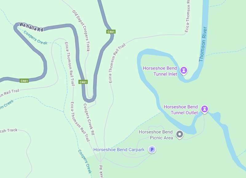
Horseshoe Bend Tunnel Walk Map
Access for Dogs:
Dogs are permitted on leash.
Information Panels:
HORSESHOE BEND TUNNEL
The Thomson River Diversion Tunnel, more commonly known as the Horseshoe Bend Tunnel, is located about 4km south-west of the historical Walhalla township, and 1.5kms below where Stringers Creek joins the Thomson River. The Tunnel was driven through a ridge of land known as the Stockriders Spur, around which the river formed its characteristic horseshoe bend.
Diversion tunnels facilitated alluvial gold mining along the former courses of rivers. Once completed, the river would flow through the tunnel, leaving the riverbed to be sluiced for alluvial gold.
Construction of the Tunnel was undertaken by the Thomson River Alluvial Gold & Tailings Recovery Company in 1911. Work started at the outlet end and the tunnel was driven at an incline through the slate rock. Construction was complete in October 1912, by blasting through rock at the inlet end. The total length of the tunnel is 220 metres and its height averages 4 metres. The entrance and exits of the tunnel contribute to the significance as the most visible evidence of the scope of the undertaking.
Horseshoe Bend Tunnel is of historical and archaeological significance to Victoria and is testimony to an industry that had dominated Gippsland for 50 years. The settlement of the Walhalla area from the mid 1860s had been the basis of reef mining. With the rapid decline in the fortunes and subsequent closure in 1914 of such prolific mines such as Long Tunnel, the sluicing of this part of the Thomson River was one of the last initiatives to win payable gold. Sluicing for alluvial gold in the Thomson River in 1912 had turned the Walhalla wheel full circle from the first prospectors working for gold in Stringers Creek in the early 1860's. The Tunnel is one of the last and longest diversion tunnels constructed for the winning of
gold in Victoria.
The Tunnel is socially significant as a component of one of Victoria's most evocative mining landscapes. The tunnel contributes to a unique cultural and historical landscape, which was dominated by gold in the nineteenth century, but a landscape with little permanent evidence of its former importance.
A GALA OPENING FOR AN ENGINEERING FEAT
During the month of August in 1911, the Thomson River Alluvial Gold & Tailings Recovery Company drove the first 215 feet into soft rock at the entrance of the diversion Tunnel.
After hitting hard rock and having little success with manual extraction methods, it was decided that the job to complete the Tunnel be tendered. William John Hannaford (better known as Jack) secured the project.
Jack's parents emigrated from England in June 1876 and settled in Moonta, South Australia, where Jack was born on 6 January 1884.
In 1890, they moved to Walhalla, finally settling on the west side of the Thomson River, downstream from Thomson Railway Station that still stands today. When Jack married in 1908, he built a dwelling on the east side of the Thomson River opposite his parents. He was not a miner, but a "jack-of-all-trades".
At the time of the Tunnel diversion project, he had four children. His wife Clara used to help him in labour, wheeling rock out on the trolley after blasting.
The Tunnel opening was to be a gala day. Both the tunnel approaches from the entrance and exit had been completed, leaving only a thin separation wall of rock, which would be blown on the day of the opening with great fanfare. Everything was in readiness, with the charges to blow the channel open having being prepared the previous day. Unbeknown to the miner who was to set-off the explosives, Jack had taken his wife Clara and three eldest children (the youngest only 23 months old), to the river exit end of the Tunnel, to allow them one last ride on the trolley. Apparently, the miner had become impatient waiting for Jack to return, and when he did appear at the Tunnel entrance where the crowd were assembled, the cry went up to light the fuses. Being unable to stop them Jack had to scramble to safety, within moments of the channel blasting, water had engulfed the Tunnel, sweeping his wife and children out of the exit and into the river.
Fortunately, the story had a happy ending as Clara, being a good swimmer, was able to rescue them all, with young Emily needing resuscitation.
Review:
An interesting walk with a steep section down to the Thomson River, section along the river, some river crossings and the historical tunnel.
There's a steep path downhill from the carpark which winds back and forth and has seats at regular intervals for rest. Just before you reach the creek there are two picnic tables at the Horseshoe Bend Picnic Area.
You will reach a point where the track branches. It is 700m to the tunnel inlet or 200m to the tunnel outlet. For the tunnel inlet follow the narrow track beside the creek. There is an initial crossing of the creek where there are solid rocks to use for stepping stones followed by a rocky path beside the creek.
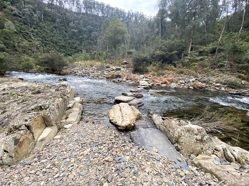
Further on there is another crossing point but when we visited the rocks that you could use to cross the creek were underwater and we decided not to continue.
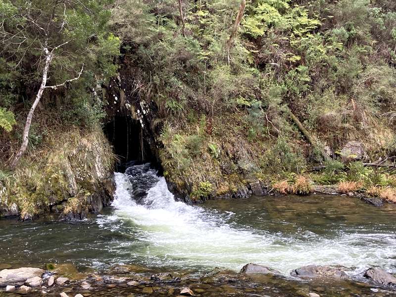
It's an easy walk to the tunnel outlet where the water roars out of the tunnel on the opposite side of the creek.
Photos:
Location
Coopers Creek Road, Coopers Creek 3825 View Map
Web Links
→ www.exploreoutdoors.vic.gov.au/activities/walking-in-victoria/horseshoe-bend-tunnel-walk


")