19 Best Bike Trails for Kids & Families in Melbourne


Melbourne has an excellent bike trail network which is a great way for families to get active and explore new areas of Melbourne. There's nothing better than the freedom and adventure of a bike trip.
It should be noted that all bike riders, adults and children must wear a properly fitting and fastened helmet that meets Australian safety standards. Also, across Victoria, you can only ride on a footpath if you are under 13 or are accompanying a child under 13. A recent law change means adults over 18 can now ride on a footpath with a child in a child seat. See a summary of road rules for cyclists.
If your bike has some mechanical problems, there are many free to use bicycle maintenance stations throughout Melbourne.
Here are the best family-friendly Melbourne bike trails and places for cycling in Melbourne. If the distance is too much for the age and experience of the kids (or parents), pick a nice section of the trail to explore. You can make use of trains to get to and from many of the trails. Bikes can be carried FREE on metropolitan trains. Please note that you cannot board at the first door of the first carriage, as this is a priority area for mobility impaired passengers. Make sure you keep passageways and doorways clear and try to avoid travelling during peak hour and busy carriages when travelling with your bike. See a summary of bikes and public transport rules.
BEST BIKE TRAILS MELBOURNE - INNER MELBOURNE
1. Capital City Trail
Capital City Trail, a shared use path for both cyclists and pedestrians, circles the Melbourne city centre and includes some inner eastern and northern suburbs. The trail is almost completely smooth pavement and is a great way of seeing Melbourne.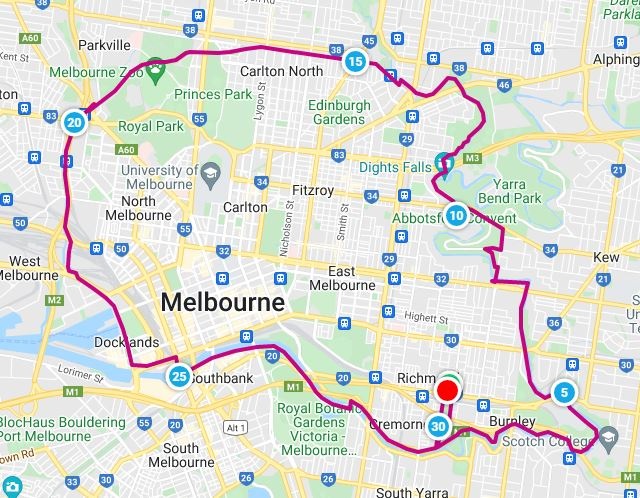
Capital City Trail by Map My Ride
The trail is 29km in length and if riding with kids it is recommended to pick a section of the complete trail. Many parts of the track are easily accessible via public transport if you want to take your bike on the train. The trail is mostly flat but there are a few challenging hills in the north-east and north-west parts and at Gipps Street in Abbotsford you need to carry your bike down a set of stairs. Since the trail is a shared path with pedestrians, take care, especially when the trail narrows in width.
The most scenic sections of the trail are along the Main Yarra Trail and through the inner north suburbs of Fitzroy, Carlton and Parkville. The Southbank section in the CBD is very crowded on weekends with pedestrians. The trail gets very crowded and you will avoid the crowds by going earlier in the day.
BEST BIKE TRAILS IN MELBOURNE - NORTH
2. Main Yarra Trail
The 40km trail meanders alongside the Yarra River upstream from Southbank in the CBD in a north-east direction, up to the junction with the Mullum Mullum Creek Trail in Templestowe. The first part of the trail is the same route as the Capital City Trail.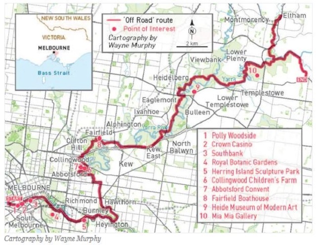
Main Yarra Trail Map from RideOn
It also passes by or comes close to many attractions including Polly Woodside, Southbank, the MCG, Royal Botanic Gardens, Herring Island Sculpture Park, Abbotsford Convent arts precinct, Dight's Falls, Collingwood Children's Farm, Studley Park Boathouse and the Heide Museum of Modern Art.
Our favourite pit stop for something to eat or drink is the Farm Cafe at Collingwood Children's Farm.
3. Merri Creek Trail
.jpg)
The 21 km one-way Merri Creek Trail is a shared use path for cyclists and pedestrians, which follows the Merri Creek through the northern suburbs of Melbourne. The path commences at Dights Falls in Clifton Hill near where Merri Creek enters the Yarra River and then takes a winding route, mainly following the creek all the way to the Western Ring Road Trail in Fawkner.
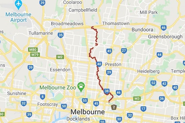
The route is sealed for its entirety but there is a a missing section in North Fitzroy that requires leaving the river cutting to cross St. George's Road.
Along the way it passes by CERES, the Brunswick Velodrome, Quarries Park Adventure playground and the Coburg Lake Reserve which has some awesome playgrounds.
BEST BIKE TRAILS IN MELBOURNE - BAYSIDE
4. Bay Trail (Brighton - Port Melbourne)
The complete Bay Trail runs between Port Melbourne and Seaford but the most popular part of the trail is the Brighton to Port Melbourne section which is 26km return. The shared path, with some sections of dedicated bike trails, is relatively flat and follows the coastline of Port Phillip Bay.
The trail passes the super playground at North Road Reserve in Brighton which has a huge pirate ship located right next to the North Point Cafe, lots of eateries near St Kilda Beach and Plum Garland Memorial playground located on the beach at Albert Park. There are plenty of beaches where you can stop for a paddle and a swim in the water.
Between Elwood and St Kilda the trail can be very busy with pedestrians, other cyclists and even roller skaters/bladers.
There are plenty of spots to have a rest including Point Ormond Cafe (29A Ormond Esplanade, Elwood) and Point Ormond Cafe (40 Beaconsfield Parade, Port Melbourne).
5. Solar System Trail (St Kilda - Port Melbourne)
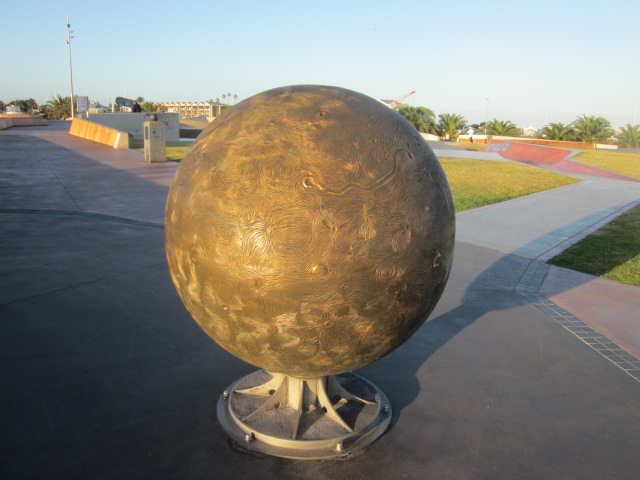
The 5.9km Solar System trail adds a celestial element to the foreshore between St Kilda and Port Melbourne. It has sun and planet sculptures along the route which replicate the solar system on a cosmic scale of one to one billion. Navigate the solar system from the sun at the St Kilda Marina Reserve to the outer planets in Port Melbourne. This trail is a subset of the Bay Trail.
BEST BIKE TRAILS IN MELBOURNE - MORNINGTON PENINSULA
6. Mornington Peninsula Bay Trail
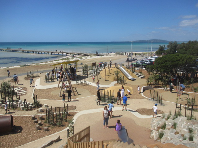
The 30km Mornington Peninsula Bay Trail is one of the most scenic shared trails on the Peninsula, winding along the foreshore, taking you in and out of the townships, stretching from Safety Beach to Portsea. The path is flat and the trail surface varies from asphalt, crushed rock and dirt.
This shared pathway offer walkers and cyclists great views as it winds its way along the foreshore reserve and is flanked by the beautiful sandy bay beaches and clear waters of Port Phillip. This means there are plenty of opportunities to hop off the bike and have a dip in the water. There are also some great playgrounds along the route - make sure you stop at the Rosebud Foreshore playground at Rosebud and Rye's Up Community playground at Rye.
BEST BIKE TRAILS IN MELBOURNE - EAST
7. Ruffey Creek Trail (Doncaster - Templestowe)
Ruffey Lake Park is an awesome place to visit with three playgrounds, with the best being along Victoria Street and lots of picnic facilities.
There is a 3km one way trail starting from near The Boulevard playground which is suited to younger kids. The surface is sealed paths with some quiet on-road sections. The trail ends at Finns Reserve which is the location of the wonderful Wombat Bend Playspace which nestles beside the Yarra River.
There are connections from Finns Reserve to the Main Yarra Trail to Westerfolds Park (northeast) and Southbank (southwest) and to the Plenty River Trail to Greensborough (Western Ring Road Trail).
8. Eastlink Trail
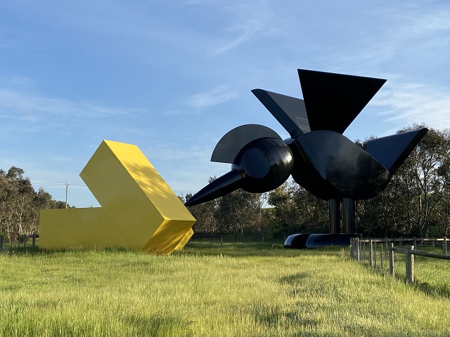
The 28km long shared use Eastlink Trail basically follows the path of the Eastlink freeway from Donvale in the north to Dandenong in the south. There are a few sections where the trail diverts from Eastlink and passes through Koomba Park, skirts the southern edge of Jells Park and Mulgrave Reserve.
The surface is mostly concrete, is generally flat but a bit hilly in the northern section. To start the trail, some people take the train to Ringwood station and follow the Mullum Mullum Creek Trail westward until it hits the Eastlink Trail.
Cycling beside a freeway may not seem the most pleasant route but the trail is actually an interesting route which passes through a number of parks and reserves and has the added attraction of outdoor sculptures along the route.
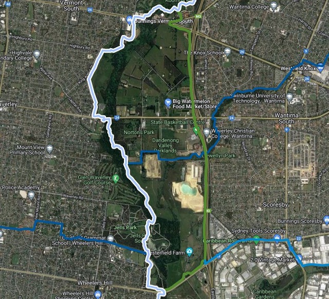
9. Jells Park Trails (Wheelers Hill)
Jells Park has a large wildlife lake with a bird hide and Dandenong Creek runs through the park. There are many bike paths criss-crossing the park which can be used to explore. A ride around the park would be up to 8km in length. Most of the paths, which are a mixture of paved and gravel, are fairly flat but there are a few slopes.
There is a lot of free parking, three playgrounds including the spectacular Yabbie Hill Playspace, a kiosk for takeaway, ice creams and coffee and Madeline's at Jells restaurant.
10. Eastlink & Dandenong Creek Trail
The Eastlink & Dandenong Creek Trail shared path which starts and finishes at Jells Park is a 16km loop through Melbourne's eastern suburbs along the EastLink and Dandenong Creek trails. The trail passes through Jells Park, Koomba Park and Bushy Park Wetlands and includes Chesterfield Farm. javaScript Cafe (645 Burwood Hwy, Vermont South) is a good pit stop.The surface is mainly sealed and smooth but there is compact gravel south along the Dandenong Creek Trail.
11. Gardiners Creek Trail
Gardiners Creek Trail is a 17km shared path that follows the Gardiners Creek through Melbourne's lovely eastern suburbs. It starts at the intersection of the Main Yarra Trail in Burnley and finishes at Canterbury Road in Box Hill South.
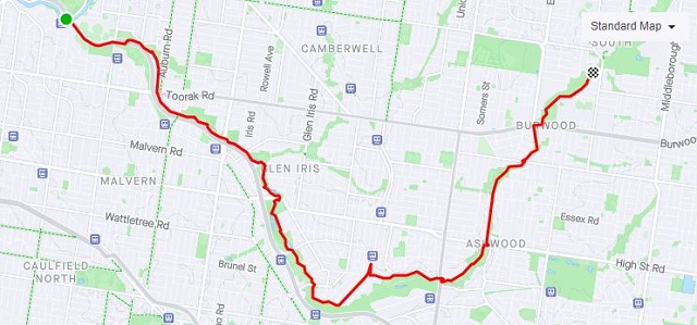
The trail is generally flat with a few gentle inclines, following a shared path that is for the most part paved and well-maintained, with very few road crossings. The path is almost entirely located within parklands or through natural reserves as it follows the creek. It can get busy on the weekend with walkers, riders and park-goers.
One of the highlights along the route is Markham Reserve which has an excellent playground beside the trail.
12. Anniversary Outer Circle Railway Trail (Kew - Ashburton)
.jpg)
The Anniversary Outer Circle Railway Trail is a shared bike and pedestrian path, which follows the tracks of the old steam era Outer Circle Line. 'Anniversary' was added to the name as part of the commemorations of Victoria's 150th birthday in 1985.
The 16km path runs from the Yarra River Trail near the Eastern Freeway in Kew, past the Gardiners Creek Trail in Ashburton and finishes at the Djerring trail at Hughesdale Station.
The trail is full paved and only has slight undulations. It can be hard to follow in places with signage lacking and utilizes local parks and pedestrian crossings. The trail is often heavily used and much of the trail passes through dog off leash areas.
The trail passes through a series of parks with nice playgrounds including Boroondara Park, Riversdale Park, Frog Hollow Reserve, Summerhill Park and Boyd Park as well as passing through the Malvern Urban Forest.
13. Maroondah Aqueduct Trail
The Maroondah Aqueduct Trail utilises the corridor of the historically significant Maroondah Aqueduct. The aqueduct was an engineering feat, following the contours of the land from Maroondah Dam in Healesville to Melbourne's storage dam in Preston.The alignment and gradient of the Maroondah Aqueduct provides for an ideal family friendly trail. The aqueduct has a relatively wide easement, picturesque setting, and a constant gradient, aside from the creek and road crossings.
The trail is 4km in length between Allendale Road, Eltham and Main Road, Research and is an off-road trail suitable for cycling, walking and running.
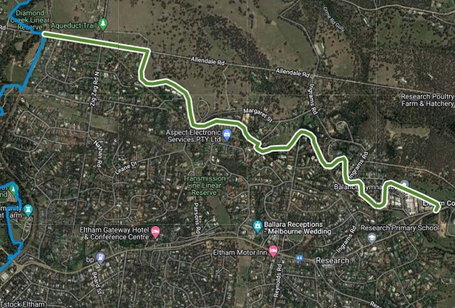
If you want a longer distance, the Aqueduct Trail joins the Research Trail to form a 10.2km trail loop around Research and Eltham North. There are playgrounds, picnic and BBQ facilities located along this trail.
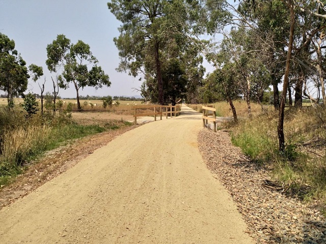
14. Diamond Creek Trail
The Diamond Creek Trail is a 11km shared use path which follows Diamond Creek through the north eastern outer suburbs of Melbourne. The trail generally follows the creek and railway from Diamond Creek to Eltham where it joins the Main Yarra Trail. The trail is fully paved and is mostly flat with some minor rises.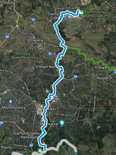
Near the start of the trail there is a great playground at the Diamond Creek Regional Playspace which has a cafe in a restored W-class tram.
The trail also passes the awesome playground at Eltham North Reserve which is next to Edendale Community Environment Farm where you can catch up with goats, sheep or alpacas (gold coin entrance donation) and have a pit stop at the cafe.
There is another nice playground at Alistair Knox Park in Eltham.
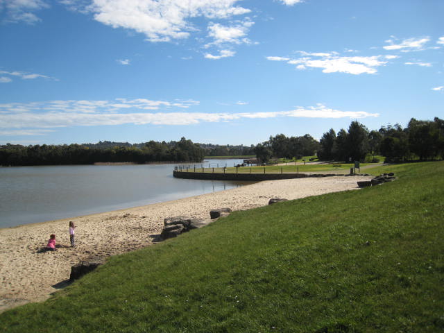
The trail ends near Eltham Lower Park (near Homestead Road, Eltham) which has a lovely fenced playground and is home to Diamond Valley Miniature Railway which operates every Sunday afternoon.
The route has a section where suburban streets have to be used to reconnect with the trail in Eltham plus there are also several road crossings and an unprotected rail crossing where care is required.
Extensions are soon to be built all the way to Hurstbridge from Diamond Creek with the route to Wattle Glen currently accessible. There are train stations at Eltham, Diamond Creek and Wattle Glen.
15. Olinda Creek Trail (Lilydale - Mount Evelyn)
The 5km long Olinda Creek Trail follows along Olinda Creek and Swansea Road between Lilydale and Quinn Nature Reserve in Mount Evelyn.
The trail passes through Lillydale Lake which has a nice playground with water play area, through Hull Road Wetlands and the follows Swansea Road before ending at Quinn Nature Reserve.
16. Yarra Valley Trail (Lilydale to Yering Station)
The first 7.5km section of the trail from Lilydale to Yering Station on Macintyre Lane has been completed and the next section from Yering to Yarra Glen is expected to be finished by late 2022. Eventually the Yarra Valley Trail will be a 40+ km long trail that will link Lilydale, Yarra Glen, Healesville and join into the Lilydale to Warburton Rail Trail.
BEST BIKE TRAILS IN MELBOURNE - WEST
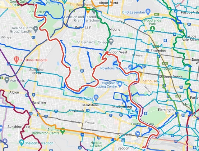
17. Maribyrnong River Trail
The Maribyrnong River Trail is a 21km shared use path which follows the Maribyrnong River through the north western suburbs of Melbourne from Brimbank Park.The path, sometimes along both sides of the river, follows the meandering of the Maribyrnong River through a valley cut in the basaltic plateau in Keilor East at Brimbank Park, then across a floodplain to Footscray. The trail is mostly flat but with does have a fast downhill slope soon after the start. The surface is a mixture of gravel, asphalt and suburban back streets.
There are many parks and playgrounds along the route including Brimbank Park which has a lovely play space, Old Canning Reserve in Avondale Heights which has a playground, Riverside Park which has a nice playground with a beautifully crafted pirate ship, the "Black Sapphire" and Maribyrnong Park which has fun playground next to The Boathouse cafe.
As the trail continues through Maribyrnong it passes through Pipemakers Park with Melbourne's Living Museum of the West, which contains historical presentations on the river valley and the people who have lived there since its initial occupation up to 40,000 years ago by the Wurundjeri people and a excellent playground.
The trail passes Quarry Park which is a fantastic mountain bike park with trails for beginners and intermediates, a skills park and two pump tracks for beginners and intermediate riders.
The path then passes by Flemington Racecourse, through Footscray Park where there is a nice playground with water play, past the impressive Heavenly Queen Temple and ends at Footscray.
18. Hobsons Bay Coastal Trail (Spotswood - Altona Meadows)
The Hobsons Bay Coastal Trail is a 23km long shared use path for cyclists and pedestrians, which follows the coast line of Hobsons Bay in the inner western suburbs in Melbourne. The trail which extends from the Westgate bridge to Skeleton creek takes you past the maritime historical precinct of Williamstown, botanic gardens, sandy beaches, wetlands with internationally important habitat, site specific public artworks and spectacular buildings.
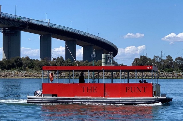
The trail starts near the terminal for the Westgate Punt at Spotswood. Every 20 minutes during weekday commuter hours and on-demand during weekends, the Westgate Punt takes cyclists to across the Yarra River to and from Fishermans Bend in Port Melbourne.
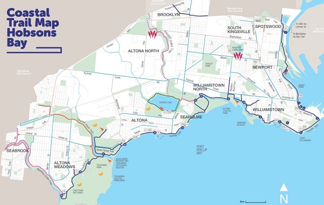
Highlights along the route include Gem Pier and Nelson Place, Point Gellibrand Coastal Heritage Park which has a nice playground and rockpools , Williamstown Botanic Gardens, Williamstown Beach and Jawbone Flora and Fauna Reserve in the Williamstown area.
As the trail moves to the Altona area, highlights include Altona Coastal Park, Cherry Lake, Altona Beach and Logan Reserve which has a playground.
At Altona Meadows there is Truganina Coastal Parklands and The 100 Steps of Federation.
The best pit stops are Kiosk d'Asporto on the beach at Williamstown (99 Esplanade, Williamstown) and Norfolk Cafe at Altona beach (139 Esplanade, Altona).
19. Kororoit Creek Trail
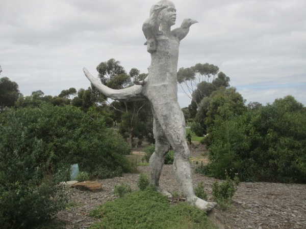
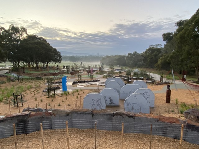
The section of the Kororoit Creek Trail in Altona North which runs beside Kororoit Creek between GJ Hosken Reserve on Blackshaws Road and Barnes Road is 1.9 km long. All the paths are wide and smooth and there are safety fences along the creek side. Along the trail there is a path leading to Harris Reserve where there is a basic playground.
The highlight of the trail are fantastic sculpture creations by renowned local artist Geoffrey Ricardo. There are eight sculptures in total to find along the trail.
The trail to the north is currently closed to July 2022 due to the Westgate Tunnel Project.
Web Links
→ Bike Tracks and Traffic Schools for Younger Riders in Melbourne
→ Places to Hire Bikes in Melbourne
→ Interactive map of walking and cycling trails in Melbourne
→ Mountain Bike (MTB) Parks in Melbourne and Victoria
→ Melbourne Bike Grid Map
→ City of Melbourne TravelSmart Map (PDF)


")