Long Forest Flora and Fauna Reserve (Long Forest)

Long Forest Nature Conservation Reserve is a 600 hectare reserve situated 50 kilometres to the west of Melbourne, between Melton and Bacchus Marsh. This park provides the opportunity to view Mallee vegetation in close proximity to Melbourne. Plants typical of arid landscapes and small creek escarpments make the reserve a fantastic retreat for bushwalkers and birdwatchers.
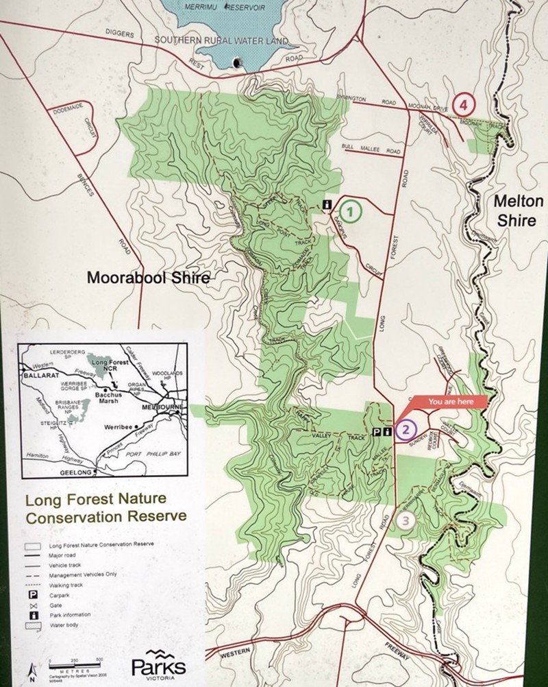
Long Forest Flora and Fauna Reserve Map
Things to Do
Walking
There are walking experiences to suit all ages, abilities and aspirations.
Walks from Canopus Circuit
(Area (1) on the map)Address: Opposite 75 Canopus Circuit, Long Forest
Long Point Track (Distance: 3 km return, Grade: 2 – Easy)
This track passes through a woodland of Bull Mallee, Red Box, Grey Box and Moonah, with shrubs such as Fragrant Saltbush, Saloop and Pigface, before reaching a pleasant waterhole on the Coimadai Creek.
Long Point via Steep Track (Distance: 3 km return, Grade: 4 – Difficult)
This track, with a very steep descent, forms a loop from the Long Point Track. It passes through Grey Box woodland to a bird-filled Blue Box flat.
Long Point via Coimadai Track (Distance: 5 km return, Grade: 3 – Medium)
Coimadai Track leaves the Long Point Track and proceeds to Coimadai Creek Track where it follows the creek north through a Blue Box flat to the grasslands at Long Point.
Walks from Happy Valley
(Area (2) on the map)Address: 210 Long Forest Rd, Long Forest
Happy Valley Track (Distance: 4 km return, Grade: 3 – Medium)
This walk through Bull Mallee and Moonah passes two frog-filled dams at an old farm site on the way to a Blue Box covered flat area on Coimadai Creek.
Old-House-Gravelly Track Circuit (Distance: 3 km return, Grade: 3 – Medium)
This walk starts at the gate 300 m south of the Happy Valley carpark. Walk through Bull Mallee, Moonah, Box, Fragrant Saltbush and patches of pale-green lichen covered rocks, to an old house site above the Coimadai Creek. The eastern half of Gravelly Track is closed.
Walks from Djerriwarrh Gate
(Area (3) on the map)Address: 1.1km north of Old Western Highway along Long Forest Road
Djerriwarrh Track (Distance: 1 km, Grade: 2 – Easy)
The walk starts at the Reserve entrance gate on the east side of Long Forest Road, 1 km north of the freeway. The track passes through stands of Bull Mallee and Grey Box before descending a rocky escarpment to grassy flats along the Djerriwarrh Creek.
Bermagui Track (Distance: 1 km, Grade: 2 – Easy)
The track starts along the Djerriwarrh Track 1 km from the Reserve entrance gate on the east side of Long Forest Road, 1 km north of the freeway. A short walk through Grey Box and Moonah leads to a large Blue Box and Manna Gum covered flat on the Djerriwarrh Creek.
Walk from Moonah Drive
(Area (4) on the map)Address: Moonah Drive, Long Forest
Moonah Circuit (Distance: 1 km, Grade: 2 – Easy)
The walk starting 400 m along Moonah Drive near the Reserve sign passes through Grey Box woodland, returning via Djerriwarrh Creek. Warning: Do not attempt this walk after heavy rain as the creek may be in flood.
Access for Dogs:
Dogs and other pets are not permitted in the reserve.
Prohibitions
Camping, firearms, fires and motorbikes are not permitted.
How to get there
Long Forest Nature Conservation Reserve is along Long Forest Road between Melton and Bacchus Marsh north of the Western Freeway. Park at one of the four access points and follow the walking tracks into the Reserve.
History
This area has cultural heritage sites that include stone artifact scatters and scar trees. Cultural objects and places are protected by law prohibiting their damage or removal.
Caring for Country is the fabric of Indigenous social, spiritual, economical and physical wellbeing and is the basis of Indigenous Australians cultural lore. This forms an important part of the heritage of all Australians, and Parks Victoria recognises these connections and acknowledges the Wurundjeri Tribe Land and Compensation Cultural Heritage Council as the Traditional Owners of this area.
Europeans first entered these Aboriginal tribal lands in 1836. In 1839 the area was mapped for European settlement. Surveyor William Darke called the area Barren Forest Hills.
Land around Djerriwarrh and Coimadai Creeks was first alienated for freehold purchase in 1855. On the plan of subdivision of 1866 the area between the creeks was described as “Thickly timbered with Box and Gum. Soil inferior. Despite quartz scattered on the ground, gold mining here failed. Poor soils ensured that attempts at cultivation also failed”.
From the 1960s scientific research in Long Forest led to calls for protection from urban subdivision. Planning appeals, negotiated development and government action helped create the reserve.
Today local landholders, Parks Victoria management of the Reserve and the Moorabool Shire Planning Scheme help to protect the area.
Plant Communities
Long Forest has the only Mallee vegetation south of the Great Divide. Bull Mallee (Eucalyptus behriana), usually found in arid and semi-arid inland areas.
The Reserve protects areas of threatened Rocky Chenopod Open Scrub/Woodland. Many of the significant plant species are at the limit of their range or grow in isolation.
Native Animals
A great place for birdwatching, a survey of birds listed 160 native species. They include endangered and threatened species such as Swift Parrot, Barking Owl, Brown Treecreeper, Speckled Warbler, Diamond Firetail and Crested Bellbird. Long Forest Mallee is important habitat for the threatened Temperate Woodland Bird Community.
Although not always easily seen, the reserve is an important home to native animals. Mammals you may see include Short-beaked Echidna, Brown Antechinus, Common Brushtail Possum, Common Ringtail Possum, Black Wallaby, Koala, native Water Rat and eight bat species.
Large groups of Eastern Grey Kangaroo can be seen grazing on the grasslands west of Coimadai Creek.
Location
Long Forest Road, Long Forest 3340 View Map
Web Links
→ Long Forest Flora and Fauna Reserve (Parks Victoria)
→ Long Forest Nature Conservation Reserve Park Note (PDF)


")