Location of Timber Trestle Bridges in Victoria

There are a number of timber trestle bridges remaining in Victoria which are mostly historic railway bridges and many now remain on rail-trails or heritage railway lines.
Where known, the location has been specified as a latitude and longitude. Enter the latitude/longitude pairs exactly into your map/search bar (e.g. -37.9004, 145.9840) to go straight to the location.
They bridge locations include:
Monbulk Creek (Puffing Billy Trestle Bridge)
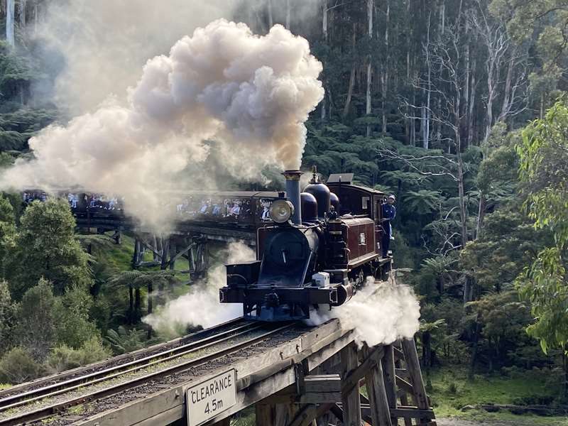
Location: Belgrave-Gembrook Road, Selby (near the intersection of Colombo Road), east of Melbourne
Coordinates: -37.9087, 145.3649
An iconic timber trestle bridge on the Puffing Billy heritage steam railway. It was built around 1899 and is about 91 m long and 12.8 m high.
Eltham Rail Trestle Bridge
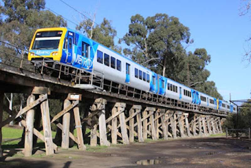
Location: Panther Place, Eltham, northeast of Melbourne
Coordinates: -37.7157, 145.14578
Historic timber railway bridge built in 1902 which is still part of the suburban Hurstbridge railway line.
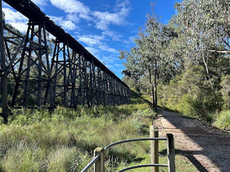
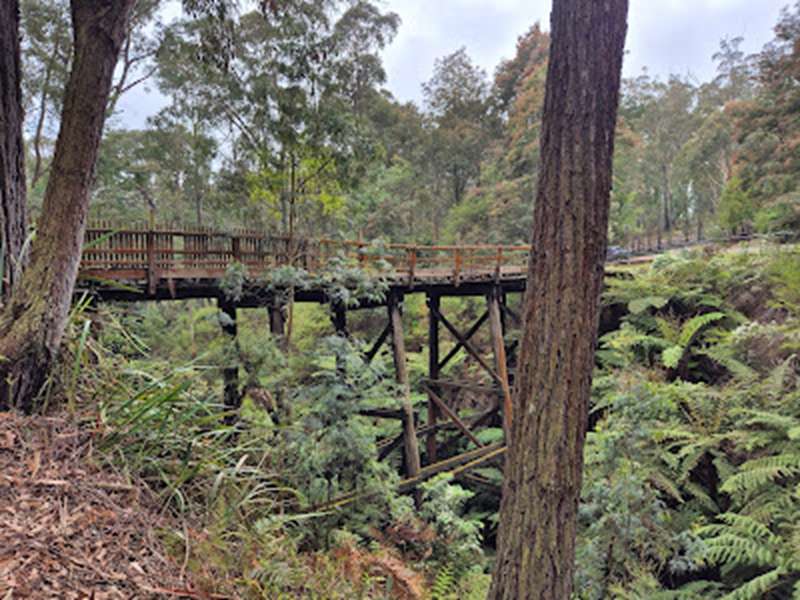
Noojee Trestle Bridge
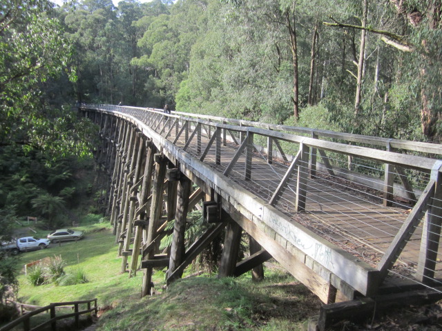
Location: Noojee Bushland Reserve, Gippsland
Coordinates: -37.9004, 145.9840
The tallest surviving timber trestle bridge in Victoria, about 21m high and 102m long, on the old Noojee railway line, now accessible via the Noojee Trestle Bridge Rail Trail. The bridge, known as No. 7, is the only one remaining of seven trestle bridges on this section of the railway between Nayook and Noojee.
Pyalong Trestle Bridge
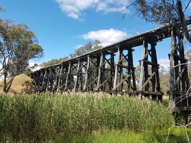
Location: Bridge Street, Pyalong
Coordinates: -37.1181, 144.8682
A largely intact timber trestle bridge over Mollison Creek which was first built in 1889 along the Wandong-Bendigo line. The line was primarily used to deliver timber shafts to the Bendigo mines before it closed in 1968. Wool and sheep were also transported on this line. The bridge is closed to the public due to the poor condition of the bridge.
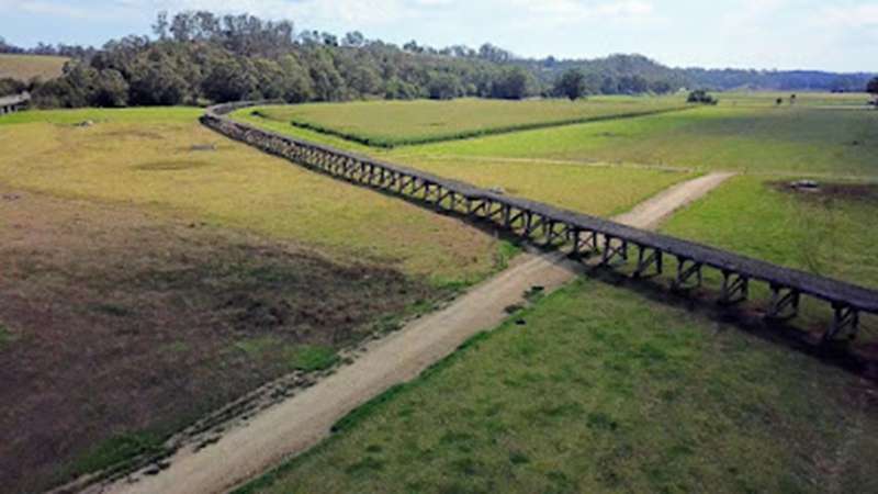
Stony Creek Trestle Bridge
Location: Old Colquhoun Road, Near Nowa Nowa, East Gippsland
Coordinates: -37.7433, 148.0439
One of the largest wooden trestle bridges in the state (approx 276m long, 20m high) which is part of the East Gippsland Rail Trail. The Stony Creek Trestle Bridge was built in 1916 when the existing rail line from Melbourne to Bairnsdale was extended to Orbost. This 97km Bairnsdale to Orbost extension through rugged terrain was reputed to have been the most difficult rail project undertaken in Victoria. In service for over 60 years the bridge was damaged by bushfire in 1980, with the last train crossing in 1988.
Due to its poor condition the bridge itself is fenced off. There are two viewing areas, one close to the top of bridge height the other at the base.
Timboon Trestle Bridge
Location: Near Timboon, south-west Victoria
Coordinates: -38.4456, 142.9598
Historic railway trestle crossing the Curdies River, now part of the Camperdown-Timboon Rail Trail.
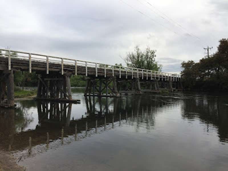
Kilcunda Trestle Bridge
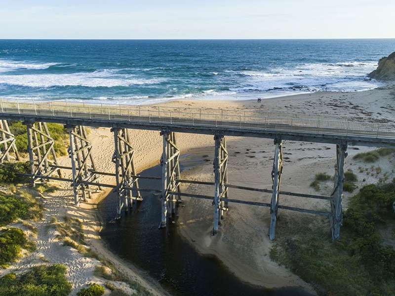
Location: Kilcunda, Bass Coast
Coordinates: -38.5545642, 145.482213
Constructed in 1911, the iconic, heritage-listed 12-metre high wooden trestle bridge stretches 91 metres across Bourne Creek at Kilcunda. The bridge formed part of the Woolamai-Wonthaggi railway until 1978, and is now a feature of the Bass Coast Rail Trail. You can pedal or stroll across the iconic bridge, making sure to stop to take in the views of the creek, the sandy Kilcunda Beach and the crashing waves from Bass Strait. The bridge is easily accessible from the Bass Highway.
Nimons Bridge
Location: 170 Galatea Road, Newtown, western Victoria
Coordinates: -37.7031, 143.6389
Historic timber trestle on the Ballarat-Skipton Rail Trail (also known as Smythe's Creek Railway Viaduct).
Spring Creek Bridge
Location: Along the Great Victorian Rail Trail (Mansfield - Tallarook) near Cathkin.
Coordinates: -37.15038, 145.59818
Spring Creek Bridge is one of three rail trestle bridges on the 6km stretch of road between the Koriella turnoff and Cathkin.
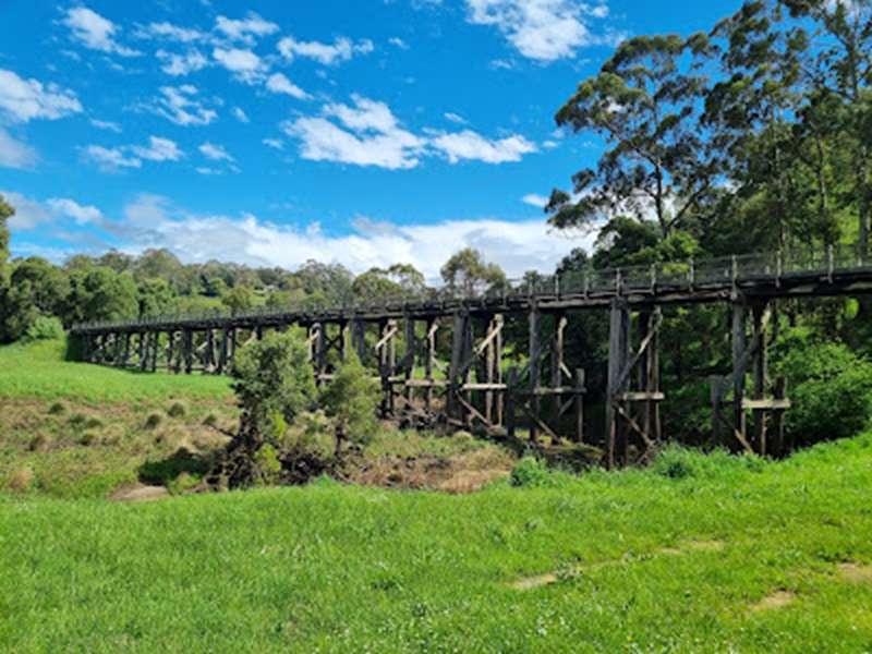
Crossover Trestle Bridge
Location: Bridge Road, Crossover, West Gippsland
Coordinates: -38.0530, 145.9662
The Crossover Trestle Bridge, constructed in 1891, spans around 40 metres with six trestles, the central of which is 15 metres tall. Trains ran between Warragul and Neerim South to transport local timber and farm produce. The railway line closed in 1958.
Marysville Timber Tramway Trestle Bridge
Location: Lady Talbot Drive, Marysville
Coordinates: -37.5087, 145.7576
The historic Marysville Timber Tramway Trestle Bridge was destroyed during the 2009 Black Saturday Bushfires which ravished the area. In 2012 the Department of Sustainability and Environment rebuilt the bridge as a heritage walking bridge, creating a beautiful and picturesque heritage tourist destination. The Historic Timber Tramway Trestle Bridge Walk is a short walk to the bridge.
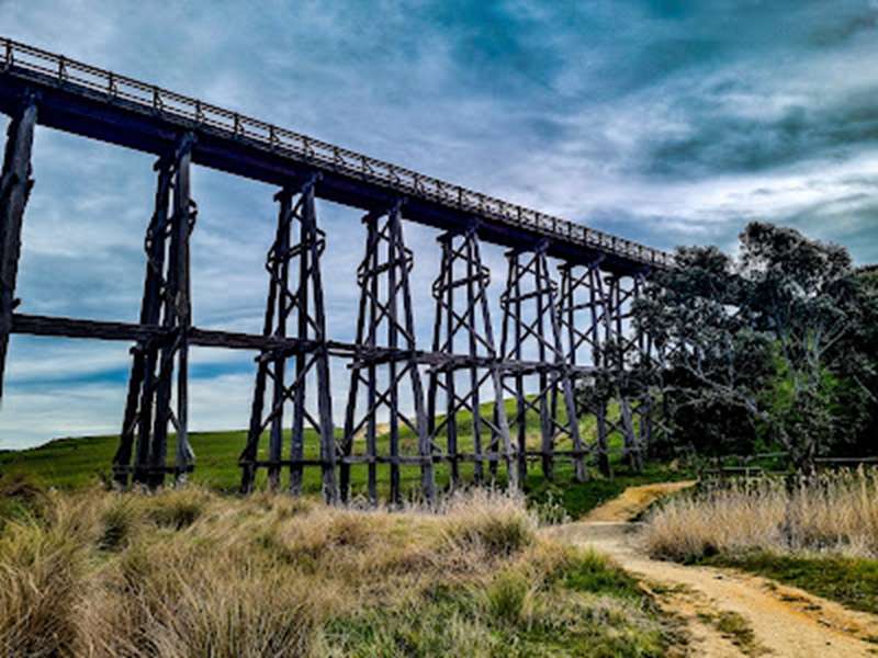
High Country Rail Trail Bridges
Location: Multiple locations
There are a number of historic timber bridges along the High Country Rail Trail between Wodonga and Shelley. Note: Some timber trestle bridges that were along the Tallangatta - Shelley section (including Bullioh and Koetong) of the Trail were burned or severely damaged in the January 2026 bushfires which will affect some of these walks below.
The 8.4km return Darbyshire Hill & Waterfall Trestle Bridge Walk near Bullioh on the High Country Rail Trail passes Waterfall and Darbyshire Hill (No. 2) trestle bridges. Both bridges are still standing, but in disrepair. They are for viewing only.
The 2.2km return Dry Forest Creek Trestle Walk near Bullioh on the High Country Rail Trail goes to Dry Forest Creek Trestle Bridge. This is the most accessible of the trestle bridges and was restored between 2015 and 2019 by volunteers from the Tallangatta Rail Trail Advisory Group.
The 77m long Boggy Creek Trestle Bridge, located four kilometres west of Koetong, was built in 1915 as part of the Wodonga - Cudgewa railway line, which operated from the early 20th century until rail services ceased in the mid-1990s. There is another trestle bridge in the area, the Edgars Road Trestle Bridge, which is located in Koetong with access from Edgars Road.
Snowy River Railway Bridge
Location: Orbost area
Coordinates: -37.72476, 148.445946
The Snowy Rail Bridge is the eastern end of the railway line that linked Orbost to Bairnsdale and the wider world between 1916 and 1987. The iconic trestle bridge over the Snowy River floodplain is 770 metres long - making it the longest timber rail bridge in Victoria.
In the late 19th century, farms along these fertile floodplains thrived, growing huge harvests of maize and beans, as well as rearing pigs, cattle and horses. But transport to market, by sea or along dirt roads was slow and unreliable. Extensive lobbying by the community eventually led to the railway line being extended to Orbost from 1912-16, in a project that would change the face and fortunes of the region.
In addition to the great agricultural and dairy harvests, the opening of the railway line gave birth to a significant new hardwood industry, which was providing half of Victoria's telegraph poles and a quarter of its railway sleepers by the 1920s. With better roads and buses, the railway eventually stopped taking passengers in 1935. But timber from the forests kept the railway going - particularly to feed the surging housing boom in Melbourne.
After the railway closed in August 1987, the bridges started to decay and the Orbost Railway Station was dismantled and removed. The great Snowy Rail Bridge may have fallen into disrepair, were it not for the determined efforts of the local community - and a new icon called the East Gippsland Rail Trail.
From 2015, the Big Red Bike and Save the Snowy Rail Bridge campaign brought the legendary landmark back into the public eye. The clamour for preservation eventually delivered lifesaving repairs in 2024, with funding from the Victorian and Commonwealth governments.
Stage 1 of restoration has been completed and visitors can now walk or cycle out onto each end of the historic Snowy Rail Bridge. Interpretive signage helps explain the bridge's history. The overall project aims to eventually install decking and safety rails so that the entire bridge forms a continuous part of the East Gippsland Rail Trail for walking and cycling. That full integration is still in development.
Acheron Breakaway Bridge
Location: Breakaway Road, Acheron
Coordinates: -37.2399, 145.7110
The Acheron Breakaway Bridge is a wooden trestle bridge located over the Goulburn River at Acheron. It was built by May 1921, after the Goulburn River broke-away from its original alignment during a major flood event. The new alignment divided private property and created an unusual situation where the river and bridge were no longer on crown land. This land was later donated to the Government. Note: The bridge was badly damaged during the October 2022 floods and is currently closed.


")