Gardiners Creek Reserve (Ashwood - Burwood)

.jpg "Gardiners Creek Reserve (Ashwood - Burwood)")
Gardiners Creek Reserve is a linear park stretching between Highbury Road and Station Street. Within its 2 km length, visitors can enjoy BBQs, picnic facilities, a playground and extensive walking trails that meander over bridges, around billabongs and alongside the creek itself.
The reserve has wetlands, good bird-watching opportunities, dog off-lead areas as well as BBQ areas and picnic facilities.
During the week the cafe at Deakin University which is located next to the track is open.
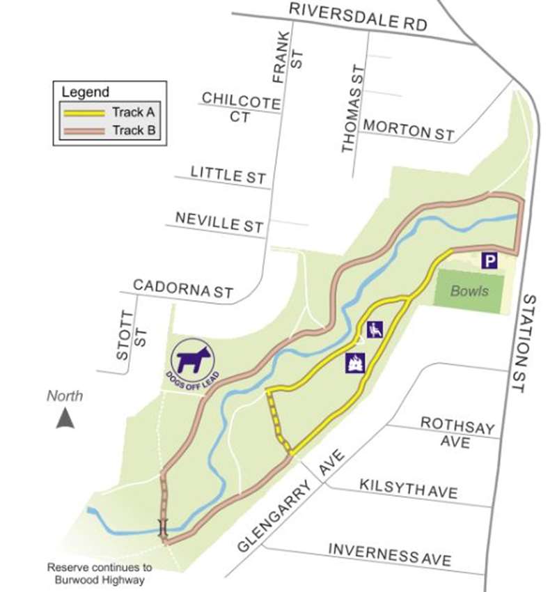
Gardiners Creek Reserve (North) Walk in Burwood
This reserve offers visitors the choice of numerous tracks around the northern section of Gardiners Creek. If travelling close to the billabong, you are likely to see a multitude of open woodland and wetland birds including the Purple Swamphen and the Little Pied Cormorant. Please refrain from allowing dogs to splash through these areas as they are precious habitat. However, enjoy the quietness of the reserve with a book, a stroll, wheeling or with friends.
Best point of access to the park is via the Bennettswood Bowling Club car park, located in Station Street, Box Hill South.
Track type: Two circuit walks. Shared trail for cyclists and walkers. Track A is 0.8km beginning at the Bennettswood Bowling Club - a short walk on the southern side of the creek. Track B is 1.5km beginning at the Bennettswood Bowling Club - a long walk around Gardiners Creek.
Level of difficulty: Easy for walkers.
Level of accessibility: Medium for Track A. Difficult for Track B.
Facilities: Picnic tables, BBQs, dog off lead areas.
Track surface: Unsealed tracks in most sections except a small stretch near the entrance to the park off Station Street.
History of Gardiners Creek:
Gardiners Creek is significant as it forms part of the City of Boroondara's southern boundary. It's also where John Gardiner became the first white settler on our side of the Yarra River.
Gardiner, and a sea captain named John Hepburn and a Durham cattle-breeder named Joseph Hawdon, arrived from Sydney late in 1836 with a herd of cattle. Gardiner returned again in April 1837, with his wife and daughter, and settled near the junction of the Yarra River and what was then known as Kooyongkoot Creek. The creek was later renamed after him.
But long before Gardiner's arrival, the banks of Kooyongkoot Creek were a source of vegetation used for food, tools and medicine by the local Aboriginal people, the Wurundjeri. The Wurundjeri people's skills and adaption to their environment meant they were able to sustain their lifestyle for many thousands of years with minimal impact to the environment.
The first survey plans of the area were drawn on a mile square grid. They showed rivers and creeks, the sites of the first squatters, tracks and descriptions of the countryside. They were later updated to include parish boundaries, the first landowners and land sold by the government.
During the 1830s people had to cross the creek or Yarra River by boat to reach John Gardiner's property, but by 1861 there were two bridges, one at Auburn Road and another at Tooronga Road. Three more bridges, at Toorak, Glenferrie and Burke roads, were completed by 1874. Further changes came during the 1930s Depression when Gardiners Creek was straightened in sections by men on sustenance (welfare payments during the Depression).
In the 1950s Gardiners Creek was still more or less in its original state, with various tributaries flowing into the creek, and local children could catch tadpoles and blackfish in its waters. It flooded regularly in parts of Ashburton and Glen Iris.
These days those tributaries have been barrelled and some stretches of the creek have been diverted around the path of the Monash Freeway and its exits.
Review:
We started in the middle location of the walk near Malmsbury Drive, Ashwood and headed north to Highbury Road. This is the most interesting section and also extends across Highbury Road to the Local History Park to the north. At Malsbury Drive it is 1.2km to Warragul Road and 1.4km to Highbury Road.
On the side of the concrete path are some small wetlands areas. The path has Gardiners Creek (in a concrete channel) on one side which is fenced to stop access. After 500m you come across a playground with a birds nest swing, carousel and unusual slide plus an unshaded table. You feel quite isolated from surrounding houses by the strip of bushland.
Photos:
Location
175 Burwood Highway, Burwood 3125 View Map
Web Links
→ Gardiners Creek Linear Walk (PDF)
→ Gardiners Creek Reserve (Walking Maps)


")