Bright & Surrounds Touring Circuit


This full day 224km touring circuit passes through Mount Beauty, Omeo, Mount Hotham and Bright.
Note: This trip is only possible when the Bogong High Plains Road is open (approx. Nov to May).
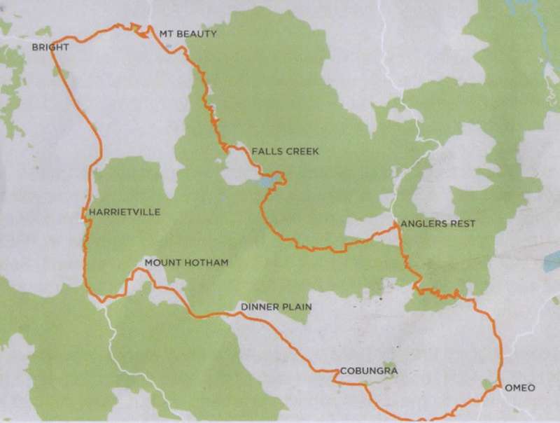
Bright & Surrounds Touring Circuit Map
Upon leaving leaving Bnght, travel 5.25kms towards Harrietville and turn left onto the TAWONGA GAP ROAD. At the top of 'The Gap', take the time to stop at the Tawonga Gap Lookout for views of the Kiewa Valley and then also at Sullivans Lookout, a couple of kms down the road, for views of the highest peak in Victoria, Mt Bogong.
At the bottom of the Tawonga Gap Road, turn right onto the KIEWA VALLEY HIGHWAY and travel through TAWONGA SOUTH to MOUNT BEAUTY. Visit the Mount Beauty Visitor Information Centre and Museum, located on the left as you head towards the Mount Beauty township. The museum includes exhibitions on Cattlemen of the High Country, first people of the Kiewa Valley and the Hydro Scheme. Stop in town for a coffee and browse through the small sub-alpine village before continuing out of Mount Beauty on the BOGONG HIGH PLAINS ROAD towards FALLS CREEK.
Approximately 15kms along you will come across the turnoff for BOGONG VILLAGE. Follow the road down to LAKE GUY to explore this picturesque village steeped in history from the establishment of the Hyrdro Electricity Scheme and renowned for beautiful European style gardens. The Bogong Power Visitor Centre is open on Sundays 10:30am - 2:30pm.
Return to BOGONG HIGH PLAINS ROAD and continue for 1km for FAINTER FALLS. Park your car in the wayside stop on the left and cross the road for an 800m walk to the waterfall. These falls were exposed during the 2006 fires and access to them was completed in December 2008.
Travel on to FALLS CREEK, a ski resort in winter and popular with hikers and mountain bikers in the warmer months. If you have a 4WD, you may like to take the optional 6km drive up to the highest drivable lookout ? Mt McKay at 1849 metres. If so, once you have passed the resort, turn right on to PRETTY VALLEY ROAD and follow it on to MT MCKAY ROAD to the summit. Return the same way to BOGONG HIGH PLAINS ROAD and turn right to continue the touring circuit.
After passing ROCKY VALLEY DAM, travel several kilometers until you see the sign 'WALLACES HUT' on the left-hand side of the road. Park the car and take the 750 metre walk to the oldest surviving cattleman's hut, built in 1889 and a magnificent display of snow gums. Another couple of kilometers along the road, you will see a sign for 'COPE HUT', which is just a 250 metre walk from the carpark to the mountaineering hut.
Continue along the BOGONG HIGH PLAINS ROAD to the OMEO HIGHWAY and turn right towards ANGLERS REST where you could have lunch at the Blue Duck Inn on the Cobungra River. It is advisable to call (03 5159 7220) to check lunch availability.
Then, head south to OMEO where you can see evidence of the earlier gold diggings before the settlers moved in with their cattle. Some of the original buildings are over 150 years old and the town also boasts the oldest wooden lockup still in original condition.
After leaving OMEO on the GREAT ALPINE ROAD towards DINNER PLAIN, look for the turn off on the right to VICTORIA FALLS - ORIENTAL CLAIMS, the site of the Chinese Diggings. There is a walking track with good signage about the history of the area. Victoria Falls are a further half hour's drive but worth the detour. They are the site of Victoria's first major hydro-electric station built in 1908 to supply water to the gold fields in CASSILIS.
Once back on the GREAT ALPINE ROAD, your next stop is DINNER PLAIN, where you could call in for refreshments and stretch your legs with either a short bushwalk or by exploring the unique alpine chalets of the Alpine village.
Continue travelling on the GREAT ALPINE ROAD onto MT HOTHAM, another ski resort in winter and popular with hikers in the warmer months. Enjoy the spectacular views as you descend on the highest sealed road in Australia, stopping at Dannys Lookout for some photo opportunities.
Another 30 kms on is the picturesque township of HARRIETVILLE which is at the base of MT HOTHAM and is home to a Lavender Farm, Trout Farm, a museum, local produce shops, cafes and pubs. You could finish your day exploring or swimming at the Tronoh Dredge Hole, turning left at Feathertop Track (Harrietville Hotel Motel) and follow the road approximately one kilometer until you see the sign for the Tronoh Dredge on your right.
Head back to the GREAT ALPINE ROAD and follow it along the Ovens Valley for 22 kms to BRIGHT, where you can enjoy a night out indulging in local food and drinks at one of the restaurants and pubs or either the Brewery or Gin Distillery while you recount the days sights of the Victorian High Country.


")