Yarra Bend Park & Dights Falls Walk (Kew)


This 5.1 km walk explores Yarra Bend Park's bushland, river scenery and historic sites. Allow about 1 hour 30 minutes. The route includes the accessible Bushland Circuit, Kane's Bridge, Galatea Lookout, Deep Rock, Merri Creek and Dights Falls.
Route Description:
Start at the Studley Park Picnic Area. Follow the Bushland Circuit through the forest, then cross Kane's Bridge for views of the Yarra River. Continue on the riverside path downstream and climb the switchbacks to Galatea Lookout. Follow the track to Deep Rock, cross the Merri Creek footbridge and visit Dights Falls. Return via the sporting ovals and Kane's Bridge.
Walking paths include asphalt, compacted gravel, dirt and rough concrete; some sections may be uneven, muddy or slippery when wet. Take care at the Yarra Bend Golf House road crossing.
Yarra Bend Park & Dights Falls Walk Map
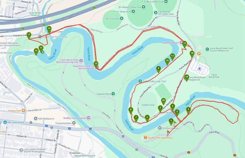
Interactive map (Walking Maps)
Points of Interest on Map
1. Studley Park picnic area
All amenities walkers may need can be found at the picnic ground. There are accessible BBQ, picnic and toilet facilities. Studley Park Boathouse serves food and drink. Signs show a map and features.
2. The Bushland Circuit
The Bushland Circuit is an accessible section of the walk. It has interpretive signs describing natural features of the area. Use this link to find the Bushland Circuit Accessible Walk
3. Kane's Bridge
This impressive wooden suspension footbridge spans the Yarra and connects the 2 loops of the Park Walk.
4. Kanes Bridge river view
Looking toward Studley Park Boathouse. Kane's Bridge offers great river views from either side.
5. Beginning of the riverside section
After you leave Kane's's Bridge and walk up the asphalt to the left, a compacted gravel path marks the start of the riverside section of the walk. Note: there are some eroded areas.
6. View to Studley Park Boathouse
This view of Studley Park Boathouse across the river shows how substantial it has become. It has a kiosk, cafe and restaurant. There are rowboats and canoes for hire.
7. Magnificent River Red Gums
These enormous trees are characteristic of the open woodland along the Yarra.
8. The track surface
Much of the track is of a dirt or compacted gravel surface. However, tree roots, muddy patches and rocky rises do appear in different sections. Keep an eye on the ground.
9. An excellent family walk
At 2 - 3 kilometres this loop walk is a comfortable distance and diverse enough to maintain the interest of all the family. Every step is a new experience throughout the 2 loops.
10. The narrowing
The path narrows here as the embankment steepens above you.
11. Galatea Point view
Looking downstream across to the narrow rive bend that is Galatea Point.
12. Switchbacks to Galatea Lookout
This rough concrete switchback path takes you up the embankment to Galatea Lookout at the ridgeline.
13. Deep Rock historic river swimming site
For around 40 years in the early 20th century this spot was so popular for swimming it had its own Life Saving Club.
14. Merri Creek foot bridge
The perfect spot for observing the Merri Creek / Yarra River confluence, this footbridge has clear views from the creek to the river.
15. Dights Falls
Dights Falls is a concrete weir that backs up the Yarra River water level for 16 kilometres. There is an excellent viewing platform built over a fish ladder from which to observe the water spill.
16. Slalom course
If you are lucky you might get to watch some of the talented kayakers who take on the rocky rapids below the weir through the slalom gates suspended overhead.
17. The turbines
The power of the Yarra was harnessed at Dights Falls from the 1840s to power various flour mill constructions. The water driven turbines can still be seen in their housing from an overhead platform.
18. Yarra Bend Golf House road crossing
This path takes you to a road crossing. There is no pedestrian zone, it is only ramped on the river side. There is no formed path on the nature strip opposite. Take care.
19. Loop Picnic Area and Playground
Atop the ridge on the site of the old asylum is a large lawn with a BBQ and picnic area. It has accessible features including shelter, BBQs, picnics tables, drinking water and parking.
20. Corben Oval public toilets
This side of the river has public toilets as well.
Access for Dogs:
Dogs must remain on a leash except in signed off-leash areas. Dog-exclusion areas apply; check the Parks Victoria dog-walking fact sheet and follow signs.
How to Get There:
The walk starts at the Studley Park Picnic Area, off Boathouse Road in Kew. Parking is available at the picnic area. Buses 200, 202 and 207 stop on Studley Park Road; walk from there to the Boathouse.
Location
1 Boathouse Road, Kew 3101 View Map
Web Links
→ www.parks.vic.gov.au/places-to-see/parks/yarra-bend-park
→ Yarra Bend Park visitor guide and map (PDF)
→ Yarra Bend Park Walk, Studley Park, Kew


