Warrnambool - Moyjil / Point Ritchie


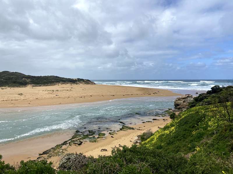
Moyjil / Point Ritchie is a rocky headland on the western side of the Hopkins River mouth, with panoramic views across the river estuary, basalt reef, Lady Bay and the Southern Ocean. Lookout paths, viewing areas and interpretive signs explore the site's Aboriginal cultural heritage, geology and natural environment.
Moyjil is an important Aboriginal place containing shell middens dating back many thousands of years. Aboriginal people visited the area to collect shellfish from the ocean and eels and other food from the Hopkins River.
Shell deposits and fire-blackened stones found at Moyjil have also been the subject of continuing archaeological and geological research. Some deposits may be much older than the recognised Aboriginal middens, although researchers have not reached agreement about whether the oldest material provides evidence of human activity.
The headland overlooks a basalt reef and the mouth of the Hopkins River. Southern right whales may occasionally be seen offshore during winter and spring, while seals can sometimes be observed among the kelp.
Features include:
- Panoramic views across the Hopkins River estuary and Southern Ocean
- Views west across Lady Bay towards the Warrnambool Breakwater
- Aboriginal cultural heritage and geological interpretation
- Ancient shell middens and protected cultural material
- Basalt reef, rocky shoreline and coastal dunes
- Several lookout points
- Connection to the Warrnambool Foreshore Promenade
- Car parking at the end of Point Ritchie Road
- Paved walking paths from the car park
- Interpretive signs
- Seats along the paths
- Fenced lookout and cultural-heritage protection areas
Some paved sections between the car park and lookout points are suitable for wheelchairs. Other sections include natural and uneven coastal surfaces.
Moyjil / Point Ritchie is protected by an Ongoing Protection Declaration under the Aboriginal Heritage Act. Visitors must remain on formal paths, obey signs and fencing, and not touch, remove or disturb shells, rocks, soil or other cultural material. Keep away from the high, undercut cliffs.
Access for Dogs:
Moyjil is within the designated off-leash area on the western side of the Hopkins River mouth. Dogs must remain under effective voice control and a leash must be carried. Keep dogs on the formal paths and away from fenced cultural-heritage areas, wildlife and other visitors. Follow the signs because different restrictions apply on the eastern side of the Hopkins River and at nearby Blue Hole Reserve.
Ritchie-Moyjil Welcome to Country Signage
Ngatanwarr wartee pa kakay Gunditjmara mirring-u. (Welcome brothers and sisters to Gunditjmara country)
You have arrived at a place of great natural and cultural significance. This is country of the Gunditjmara nation and where you are standing is where indigenous people gathered for thousands of years, harvesting and feasting on the plants and abundant seafood. This rocky outcrop at the mouth of the Hopkins River is known as Point Ritchie, or in Aboriginal language, Moyjil.
Preserved within the rocks and dunes is the story of our connection to this land over tens of thousands of years. The story is one of a sustainable culture that exists today. The lives led by our ancestors were not transient. They fished, hunted game and gathered food in chosen locations.
We want to share with you the story of Moyjil. In sharing the story we hope you get a sense of the importance of the site and the connection to the landscape felt by indigenous people over many generations.
Moyjil is a great starting point for those seeking to know more about indigenous culture across the Great South Coast region.
Moyjil: long drag net/fishing basket, refers to the western head of the Hopkins River mouth, Point Ritchie.
Scientists working with people of the Gunditjmara nation have unravelled an extraordinary human story at Moyjil. Its archaeological importance has seen Moyjil given special protection by the Victorian State Government through an Ongoing Protection Declaration.
Aboriginal people inhabited this area as sea levels rose and fell, volcanoes erupted and climate altered. When it has been a coastal location people harvested shellfish, crabs and fish from the sea. They left evidence of this in the form of middens - accumulations of the hard parts of their food (skeletons and shells) - charcoal and fireplaces.
At times of lower sea level Moyjil was an inland site with access to the Hopkins River, freshwater springs and a commanding view over a coastal plain. Hearth-like features occur on Moyjil and are older than the Tower Hill tuff which once covered them. These suggest people camped beside the Hopkins River over 35,000 years ago. Rock layers show the influence of different climatic conditions over the past 300,000 years. Sea level has risen and fallen - at its highest reaching present levels about 125,000 and 220,000 years ago.
During these times of higher sea level and milder climate (called Interglacial Periods) dunes formed on ancient coasts just as they do today (we are living in an Interglacial Period). Over time the sand grains were cemented together and the loose sand became a rock called calcarenite. The large hill to the west is a sand dune formed 125,000 years ago. The rock stack at the sea's edge is the remains of an older dune - formed over 200,000 years ago.
Between these Interglacial Periods the Earth was colder and sea level fell. The fall in sea level is caused by ice build-up on the continents - leaving less water in the oceans. These cold times are called Glacial Periods or Ice Ages. Dune building ceased here at these times and terra rosa ("red earth") soils developed on the now stable dune surface. Natural cement layers, called calcrete formed at the base of the soils because of the dry conditions. During the peak of the last Glacial Period (about 20,000 years ago) sea level was up to 130m lower than now and the coast over 80km south of Pt Ritchie.
When the sea returned to its present level about 6,000 years ago harvested shellfish could be brought to Moyjil. Both estuarine and marine species are found in shell deposits on Moyjil - its proximity to both the Hopkins River and the coast made it a favourable camping ground.
Review:
There are views over the Hopkins River estuary mouth, a little curved beach and the long Point Ritchie beach which is a dog off leash area. Next to the toilets is a water tap with dog bowl. We also saw an echidna along the path which seems to be common here based on signage.
Photos:
Location
Point Ritchie Road, Warrnambool 3280 View Map
Web Links
→ www.moyjil.com.au


