Warrnambool CBD Heritage Trail


The Warrnambool CBD Heritage Trail is a self-guided 3 km walk featuring 22 historic buildings, streetscapes and former commercial sites. The route explores the city centre between James Swan Reserve and Merri Street.
The trail can be started at any location. Most attractions are viewed from public streets, as some buildings remain private properties or operating businesses.
Walk Details:
- Distance: 3 km
- Time: Approximately 1.5-2 hours
- Route: Self-guided urban walk
- Difficulty: Easy
- Surface: Sealed footpaths with road crossings
- Recommended starting point: James Swan Reserve
Warrnambool CBD Heritage Trail Map
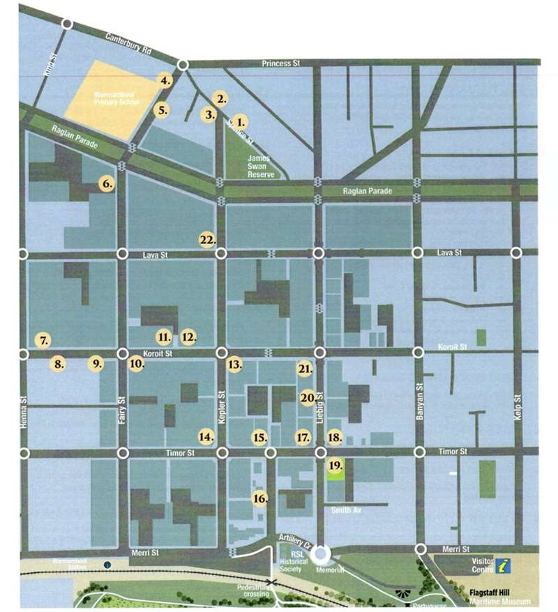
Heritage Trail Locations
1. Swan Reserve
On the site of the former Municipal Victoria Saleyards and named after Cr James Swan, Mayor from 1927-28. Note the old limestone wall. Originally Swan Reserve occupied the median strip between Kepler and Fairy Streets.
Address: James Swan Reserve, corner Kepler Street and Spence Street, Warrnambool VIC 3280
2. St John’s Church
Completed in 1875, designed by Andrew Kerr and rebuilt after it was burnt down in 1920.
Address: 28 Spence Street, Warrnambool VIC 3280
3. Jerne
This two-storey residence on the corner of Kepler and Spence Streets was built in 1883 for Dr Fleetwood.
Address: Corner Kepler Street and Spence Street, Warrnambool VIC 3280
4. Warrnambool Primary School No. 1743
The school opened in 1876. The bell tower was a later addition.
Address: 3-13 Jamieson Street, Warrnambool VIC 3280
5. Victorian Villas
Opposite Warrnambool Primary School, these nineteenth-century homes are noteworthy for their distinctive Italianate-style bargeboards.
Address: Jamieson Street opposite Warrnambool Primary School, Warrnambool VIC 3280
6. Fairy Street
Fairy Street contains a collection of historic commercial buildings and former business premises:
- 181 Fairy Street was McSweeney’s Cordial Factory
- 165 Fairy Street was the Olive Branch Hotel
- Hammond’s Paint Shop was once Elliot’s Boot Factory
- At the Lava Street corner, the building with the wheat-sheaf motif was Smith’s Bakery
- Moving south were McConnell’s Livery and Letting Stables and W.J. Taggart, tailor
- Lynch’s store later housed the merchants Russell and Powell
- Near the western Lava Street corner was a row of historic buildings once occupied by W. Stevens Produce Store, Lance the plumber, Sambell the chemist and Robinson & Morse vehicle makers
- The shops south of the Caledonian Hotel were once known as Gray’s Coliseum
Address: Fairy Street between Koroit Street and Lava Street, Warrnambool VIC 3280
7. Christ Church
This double-nave church was constructed between 1854 and 1856 to a design by architect Nathaniel Billing. The tower, designed by Andrew Kerr, was added in 1882.
Address: 230 Koroit Street, corner Henna Street, Warrnambool VIC 3280
8. Ellerslie College
Built as a school and notable for its carved limestone.
Address: Koroit Street near Henna Street, Warrnambool VIC 3280
9. Royal Archer Hotel
The Royal Archer Hotel originally stood in the area between Ellerslie College and the corner building.
Address: Koroit Street between Henna Street and Fairy Street, Warrnambool VIC 3280
10. Nayler’s Corner
Formerly known as Nayler’s Corner General Store. The building next door was Salter’s store and later Murrell’s the furrier. Note the clerestory skylights.
Address: Corner Fairy Street and Koroit Street, Warrnambool VIC 3280
11. Ambleside
This building was once a residence and surgery for several doctors.
Address: Koroit Street between Fairy Street and Kepler Street, Warrnambool VIC 3280
12. Former Warrnambool Standard Office
The western section was once part of the business of Bloomfield Brothers, skin and hide dealers.
Address: Koroit Street between Fairy Street and Kepler Street, Warrnambool VIC 3280
13. Ozone Coffee Palace
The Warrnambool Hotel stands on the site of the Ozone Coffee Palace. Built in 1890, it burnt down in 1929 while known as the Hotel Mansions. It was regarded as one of the most magnificent buildings erected in Warrnambool.
Address: 185 Koroit Street, Warrnambool VIC 3280
14. Intersection of Kepler and Timor Streets
Four buildings of note are located around this intersection: the former Bank of Australasia, the National Bank, the Western Hotel built in 1869 and the former A.M.P. office. The Western Hotel was once a Cobb and Co. staging post, while the former A.M.P. office later became part of TAFE.
Address: Corner Kepler Street and Timor Street, Warrnambool VIC 3280
15. Timor Street
This section of Timor Street contains several heritage-listed buildings. Note the tiled entrance at number 198 and the protective hub stone beside the lane.
Address: 198 Timor Street, Warrnambool VIC 3280
16. Gilles Street
An historic precinct containing the old Courthouse built in 1871, the former police station and stables, lock-up and residence, and the old Customs House.
Address: Gilles Street between Timor Street and Merri Street, Warrnambool VIC 3280
17. Commercial Hotel
Built in 1856, the former Commercial Hotel is now the Whalers Hotel.
Address: 53 Liebig Street, Warrnambool VIC 3280
18. Cramond and Dickson Store
The Cramond and Dickson store stood at the corner of Liebig and Timor Streets and traded from 1856 until 1973.
Address: Corner Liebig Street and Timor Street, Warrnambool VIC 3280
19. Timor Street and the Civic Green
Flanking the Civic Green are two remnants of Warrnambool’s former main commercial centre. Number 163 Timor Street was once known as Scherell’s Building and housed the National Bank. Facing Liebig Street is the former Steam Navigation Company office, built in 1886 and now incorporated into the Warrnambool Art Gallery.
Address: Civic Green, corner Timor Street and Liebig Street, Warrnambool VIC 3280
20. Liebig Street
Most of the two-storey buildings along this section of Liebig Street were erected during the late 1800s.
Address: Liebig Street between Timor Street and Koroit Street, Warrnambool VIC 3280
21. Fletcher Jones Corner
The corner of Liebig and Koroit Streets was once occupied by the famous Fletcher Jones men’s clothing store.
Address: Corner Liebig Street and Koroit Street, Warrnambool VIC 3280
22. St Joseph’s Church
Completed in 1872, the church’s spire was added in 1886 and later shortened following damage caused by a lightning strike. The original church on the site stands near the Raglan Parade and Kepler Street corner.
Address: 169 Kepler Street, Warrnambool VIC 3280
Starting Point:
James Swan Reserve, corner Kepler Street and Spence Street, Warrnambool VIC 3280.
The trail may also be started near the Warrnambool Visitor Information Centre at 89 Merri Street, Warrnambool VIC 3280.
Access for Dogs:
Dogs are permitted along public streets and in applicable public reserves but must be kept on a leash. Dogs may not be permitted inside churches, businesses and other buildings, except for assistance animals.
Location
Cnr Kepler Street and Spence Street, Warrnambool 3280 View Map


