The Great Ocean Road Bronze Plaques


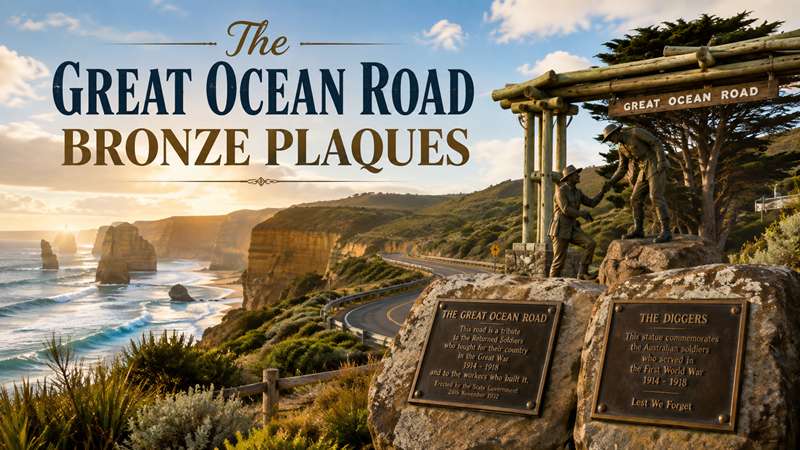
The making of the Great Ocean Road is a story of resolve and conquest over adversity, and a triumph of great Aussie spirit and mateship.
BUILDING THE GREAT OCEAN ROAD
A MEMORIAL OF BLOOD, SWEAT AND ANGUISH... Returned soldiers built the road, constructed as a permanent memorial to those who died while fighting in the First World War. It was a huge engineering feat with blood, sweat and anguish, resulting in faster access for vehicles via a coastal route from Barwon Heads via Lorne to Warrnambool. The ocean provided the first connections with coastal settlements that mostly sprang up for commercial reasons. Some early settlers hunted whales and seals while others harvested the huge trees of the Otways.LINKING SETTLEMENTS
Inland routes were developed but they were slow and arduous. A railway was established in the 1870s linking Geelong and Winchelsea, with a coach connection to Lorne. Plans for an ocean road emerged in the 1880’s but were shelved because of cost and defence reasons.
New impetus for an ocean road came towards the end of the First World War. The chairman of the Country Roads Board, Mr W Calder, contacted the State War Council with a proposal that funds be provided for repatriation and re-employment of returned soldiers on roads in sparsely populated areas. This was after the war council had pressed him to employ returned soldiers.
PLAN FOR A ROAD
Calder soon submitted a plan he described as the ‘South Coast Road (Western District)’. It suggested a road starting at Barwon Heads, following the coast west around Cape Otway and ending near Warrnambool. The plan was published in December 1917 and the Geelong mayor, Alderman Howard Hitchcock, said he would organise a scheme for its construction. The road would be built by returned soldiers as a memorial to all those who were killed in the Great War. By May 1918 the Great Ocean Road Trust had been formed. It decided the first stage would be built from Lorne to Cape Patton, a distance of 28.9km (18 miles).
AN EXPLOSIVE START
Survey work began in August 1918 but the difficulty of the terrain and bad weather hampered progress. It was completed just over 13 months later, with 57.6km (36 miles) of road from Cape Patton to Eastern View pegged out. Construction work, using thousands of returned servicemen, officially began on September 19 1919, when the Premier of Victoria, Mr Lawson, detonated an explosive charge near Lorne.
MANUAL ENTHUSIASM
Initially a lack of funds delayed progress on the road but government helped renew enthusiasm for the project and the first stage linking Lorne and Eastern View was completed in early 1922. Over the next decade, the trust continued its work on the Great Ocean Road with Cape Patton and Anglesea, while the Country Roads Board built the Cape Patton to Apollo Bay link. It was tough work with no heavy machinery to help - only picks, shovels and horse-drawn carts.
AND FINALLY, A ROAD
On November 26 1932, the route was officially opened by the Lieutenant Governor, Sir William Irvine. It was a sight to see with a procession of 40 cars and schoolchildren lining parts of the route. At Apollo Bay, there were sports on the foreshore, and the Colac band travelled to Wye River to play during the afternoon. Road travellers during the early years paid a toll at gates at Eastern View, where a memorial arch was erected. Drivers paid two shillings and sixpence (25 cents AUD) and passengers one shilling and sixpence (15 cents AUD). The toll was abolished when the Trust handed the road over to the State Government on October 2 1936.HISTORIC MARKERS
In 2007, as part of the Great Ocean Road’s 75th anniversary celebrations, a series of commemorative bronze plaques and a statue at the Great Ocean Road Memorial Arch were unveiled. The aim of these is to bring alive for travellers the stories of the people who lived and worked in the region. Hand sculptured by Dr Ross Bastiaan, and weighing 85 kilograms, each of the thirteen plaques feature information on the broad history of the road, a central detailed relief map of the area and information specific to the site they occupy.THE GREAT OCEAN ROAD
On 26 November 2007 the Great Ocean Road turned 75. It was a time to remember the road’s wonderful past and to celebrate its present - and its future - as one of the greatest journeys on the planet.The 3000 brave men who between 1918 and 1932 built the road, often using little more than a pick and shovel, would today be immensely proud of how their creation has not only weathered the years, but blossomed into a destination dubbed by the English travel magazine, Conde Nast Traveller, as one of the Top 20 journeys of a lifetime.
Across the Atlantic, Frommer’s, the American travel Bible, put the Great Ocean Road in its top 10 road trips in the world. As well as being an iconic tourist destination, the Great Ocean Road plays a deeper, more spiritual role. It is also the world’s biggest war memorial. The men who decades ago etched it into the coastline of south western Victoria, themselves returned soldiers, were building it in honour of their comrades killed in the First World War.
THE DIGGERS, GREAT OCEAN ROAD MEMORIAL ARCH
In April 2007, a special ceremony was held at Eastern View to unveil “The Diggers”.
With one of the workers handing the other a drink, this work reflects the great Australian mateship that was not only a part of the building of the road, but which was so often on display in the First World War itself.
Set on a plinth of rock especially brought in from Port Fairy, “The Diggers” overlooks the Southern Ocean and the road. The landscaped car park and boardwalks are a safe place to create the perfect photo record of a visit to the Great Ocean Road, with the Memorial Arch in the background.
GREAT OCEAN ROAD BRONZE PLAQUES
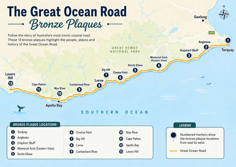
TORQUAY Location: Highway Reserve beside the roundabout where the Surf Coast Highway meets the Great Ocean Road, Torquay.
.jpg)
Located at Spring Creek, the officially gazetted start of the Great Ocean Road. From humble colonial beginnings, Torquay has grown into a fine, year round seaside holiday resort and the capital of the surfing industry in Australia.
TORQUAY
OFFICIAL START OF THE GREAT OCEAN ROAD
THE GREAT OCEAN ROAD (GOR) WAS BUILT AS A LIVING MEMORIAL TO THE VICTORIANS WHO SERVED IN THE FIRST WORLD WAR (1914-18). IT WAS COMPLETED IN 1932 AND SPECTACULARLY OPENED THE COASTAL AREAS TO TOURISM AND DEVELOPMENT.
ALTHOUGH A COASTAL ROAD WAS CONCEPTUALISED FOR DECADES IT WAS NOT UNTIL 1918 THAT A ROUTE WAS PEGGED AND THE GREAT OCEAN ROAD TRUST ESTABLISHED. FUNDING WAS RAISED FROM THE RETURNED SERVICES LEAGUE AND LOCAL COMMUNITIES, AS THE STATE GOVERNMENT WAS RELUCTANT.
THE FIRST SECTION, LORNE TO THE CUMBERLAND RIVER, WAS BEGUN IN SEPTEMBER 1919 BUT WAS SO SLOW AND UNDERFUNDED THAT BY 1920 COMMUNITY PRESSURE HAD FORCED THE RELOCATION OF THE TWO WORK TEAMS OF 150 MEN EACH TO THE LORNE AND AIREYS INLET SECTION. THE RETURNED SOLDIERS WERE WELL PAID AND LIVED IN TENTS IN A COMMUNAL CAMP SPIRIT REMINISCENT OF THEIR WAR YEARS, AS WERE THE PLACE NAMES ALONG THE ROAD.
LORNE TO AIREYS WAS OFFICIALLY OPENED IN MARCH 1922. THE SINGLE LANE, UNSEALED ROAD HAD FEW GUARD RAILS AND TRAFFIC WAS ONE-WAY DURING CERTAIN HOURS WITH A TOLLHOUSE AT GRASSY CREEK. AS SPEED WAS LIMITED ACCIDENTS WERE RARE.
FOR THE NEXT DECADE, HUNDREDS OF MEN TOILED IN RUGGED, WILD TERRAIN BUILDING THE ROAD BETWEEN CAPE PATTON AND LORNE FOR THE TRUST AND CAPE PATTON AND APOLLO BAY FOR THE COUNTRY ROADS BOARD (CRB). HUGE GEOGRAPHICAL OBSTACLES WERE GRADUALLY OVERCOME IN AN ERA OF 'PICK AND SHOVEL' ROAD CONSTRUCTION.
AS THE VOLUME OF TRAFFIC GREW, WIDENING AND SAFETY IMPROVED AND THE ROAD WAS PART METALLED FROM 1934. THE TOLL WAS REMOVED IN 1936 WHEN THE GOR TRUST RELINQUISHED CONTROL TO THE STATE GOVERNMENT.
SUBJECT ALWAYS TO THE ELEMENTS, THE GOR EXPERIENCES ROAD SLIPPAGE AND LAND SLIDES WHILST BUSH FIRES ARE AN ANNUAL SEASONAL THREAT. THE ROAD'S UNRIVALLED BEAUTY IS A LASTING TRIBUTE TO THE MEMORY OF THOSE WHO SERVED THEIR NATION IN WAR AND THE 3000 MEN WHO BUILT IT.
HISTORY TORQUAY
THE INDIGENOUS WATHAURUNG PEOPLE WERE THE ORIGINAL OCCUPANTS OF THE TORQUAY AREA AND PROVIDED SHELTER TO ESCAPED CONVICT WILLIAM BUCKLEY FROM 1803 TO 1835. ROBERT ZEALLY, FOR WHOM ZEALLY BAY IS NAMED, TOOK UP LAND IN THE AREA IN 1851.
BY THE 1860s THE BEAUTIFUL BEACHES AND THE SPRING CREEK PICNIC AREA WERE ATTRACTING DAY TRIPPERS FROM AS FAR AWAY AS TWENTY TWO KILOMETRES. SETTLERS IN JAN JUC OPENED THE REGION'S FIRST SCHOOL IN 1861 AND IN THE 1870s CAMPERS AND FISHERMEN ESTABLISHED A TOWNSHIP CALLED SPRING CREEK, WHICH BOASTED A WINE CAFE AND BOARDING HOUSE.
A PUBLIC LAND SALE IN 1886 INCREASED HOUSING IN SPRING CREEK AND THE TOWN BECAME VICTORIA'S FIRST SEASIDE RESORT, COMPLETE WITH PUBLIC LAWNS, PICNIC GROUNDS AND PROMENADES. SPRING CREEK WAS RENAMED TORQUAY IN 1892 TO AVOID CONFUSION WITH OTHER SIMILARLY NAMED PLACES IN THE COLONY AND BECAUSE SOME OF THE TOWN'S RESIDENTS WERE ORIGINALLY FROM TORQUAY, ENGLAND.
SPRING CREEK AT TORQUAY WAS GAZETTED IN 1936 AS THE START OF THE 240 KILOMETRE GREAT OCEAN ROAD. DURING THE SECOND WORLD WAR, DEEP CREEK WAS A TRAINING BASE FOR 4500 SOLDIERS WHILST POINT ADDIS HAD A LARGE AIR FORCE TRAINING RANGE THAT EXTENDED SEAWARD TO WYE RIVER. TORQUAY WAS ALMOST LOST IN 1940 WHEN BUSHFIRES DESTROYED 90 HOMES.
THE TORQUAY SURF LIFE SAVING CLUB WAS STARTED IN 1946, THE FIRST IN VICTORIA. THE FAMOUS SURF AT BELLS BEACH HAS ATTRACTED GENERATIONS OF SURFERS AS WELL AS WORLD FAMOUS SURFING PRODUCT MANUFACTURERS AND RETAILERS. A SURFING CONTEST HELD AT BELLS BEACH EVERY EASTER SINCE 1962 IS NOW THE LONGEST CONTINUOUSLY RUNNING SURFING CONTEST IN THE WORLD AND ATTRACTS THOUSANDS OF VISITORS.
IN 1994 TORQUAY BECAME THE ADMINISTRATIVE CENTRE OF THE NEW SURF COAST SHIRE.
TODAY, THE MAGNIFICENT SURF BEACHES, SURF HISTORY AND CULTURE, TOWERING OCHRE CLIFFS AND DENSE BUSH ENSURE THE POSITION OF TORQUAY AS THE SPIRITUAL HOME OF AUSTRALIAN SURFING.
REPRESENTING THE EARLY GENERATION OF SURFERS THAT MADE TORQUAY FAMOUS THROUGHOUT THE SURFING WORLD IS VIC TANTAU (1928 - 1993). HE WAS A SURFING CHAMPION OF TORQUAY IN THE 1950s AND A FOUNDING FATHER OF THE BELLS BEACH CLASSIC AND THE TORQUAY SURF LIFE SAVING CLUB.
VIC IS SHOWN HERE HOLDING ONE OF HIS FAMOUS HAND-MADE 4.8 METRE BOARDS. HE ESTABLISHED THE FIRST COMMERCIAL SURFBOARD MANUFACTURING BUSINESS LOCALLY AND MADE ALMOST 1000 BOARDS PAVING THE WAY FOR A FLOURISHING SURFING INDUSTRY.
Howard Hitchcock, President of the original Great Ocean Road Trust wrote the following in the MELBOURNE HERALD, January 3, 1931.
“Perhaps from the first, people dreamed of a great ocean road which should follow the picturesque coast line, link up the townlets and make this lovely area more accessible; but if they did, it was only a dream which seemed impossible of realisation, and so our dream comes true. The great ocean road will stand as a monument to persistent, self-sacrificing effort. It is a highway made as a fitting memorial to the deeds of our soldiers, but it is also a convenient means of outlet for traffic from remote hills and valleys, a stimulus to settlement and a scenic roadway which is unsurpassed in the Commonwealth.”
ANGLESEA
Location: On the banks of the Anglesea River in the heart of Anglesea.
.jpg)
The plaque is located on the banks of the Anglesea River in the heart of the town. Anglesea takes pride in being the place where the Great Ocean Road first comes into contact with the Southern Ocean.
ANGLESEA
THE GREAT OCEAN ROAD
THE GREAT OCEAN ROAD (GOR) WAS BUILT AS A LIVING MEMORIAL TO THE VICTORIANS WHO SERVED IN THE FIRST WORLD WAR (1914–18). IT WAS COMPLETED IN 1932 AND SPECTACULARLY OPENED THE COASTAL AREAS TO TOURISM AND DEVELOPMENT.
ALTHOUGH A COASTAL ROAD WAS CONCEPTUALISED FOR DECADES IT WAS NOT UNTIL 1918 THAT A ROUTE WAS PEGGED AND THE GREAT OCEAN ROAD TRUST ESTABLISHED. FUNDING WAS RAISED FROM THE RETURNED SERVICES LEAGUE AND LOCAL COMMUNITIES, AS THE STATE GOVERNMENT WAS RELUCTANT.
THE FIRST SECTION, LORNE TO THE CUMBERLAND RIVER, WAS BEGUN IN SEPTEMBER 1919 BUT WAS SO SLOW AND UNDERFUNDED THAT BY 1920 COMMUNITY PRESSURE HAD FORCED THE RELOCATION OF THE TWO WORK TEAMS OF 150 MEN EACH TO THE LORNE AND AIREYS INLET SECTION. THE RETURNED SOLDIERS WERE WELL PAID AND LIVED IN TENTS IN A COMMUNAL CAMP SPIRIT REMINISCENT OF THEIR WAR YEARS, AS WERE THE PLACE NAMES ALONG THE ROAD.
LORNE TO AIREYS WAS OFFICIALLY OPENED IN MARCH 1922. THE SINGLE LANE, UNSEALED ROAD HAD FEW GUARD RAILS AND TRAFFIC WAS ONE-WAY DURING CERTAIN HOURS WITH A TOLLHOUSE AT GRASSY CREEK. AS SPEED WAS LIMITED ACCIDENTS WERE RARE.
FOR THE NEXT DECADE, HUNDREDS OF MEN TOILED IN RUGGED, WILD TERRAIN BUILDING THE ROAD BETWEEN CAPE PATTON AND LORNE FOR THE TRUST AND CAPE PATTON AND APOLLO BAY FOR THE COUNTRY ROADS BOARD (CRB). HUGE GEOGRAPHICAL OBSTACLES WERE GRADUALLY OVERCOME IN AN ERA OF ‘PICK AND SHOVEL ROAD CONSTRUCTION’.
AS THE VOLUME OF TRAFFIC GREW, WIDENING AND SAFETY IMPROVED AND THE ROAD WAS PART METALLED FROM 1934. THE TOLL WAS REMOVED IN 1936 WHEN THE GOR TRUST RELINQUISHED CONTROL TO THE STATE GOVERNMENT.
SUBJECT ALWAYS TO THE ELEMENTS, THE GOR EXPERIENCES ROAD SLIPPAGE AND LAND SLIDES WHILST BUSH FIRES ARE AN ANNUAL SEASONAL THREAT. THE ROAD’S UNRIVALLED BEAUTY IS A LASTING TRIBUTE TO THE MEMORY OF THOSE WHO SERVED THEIR NATION IN WAR AND THE 3000 MEN WHO BUILT IT.
ANGLESEA WAS PART OF THE KUARKA DORLA AREA INHABITED BY THE WATHAURONG ABORIGINES. SETTLERS FIRST BROUGHT SHEEP FARMING HERE IN THE 1850s WHEN IT WAS KNOWN AS ‘SWAMPY CREEK’.
ADVENTUROUS HOLIDAY MAKERS RODE THROUGH DENSE IRON BARK FORESTS TO CAMP BESIDE THE ANGLESEA RIVER WITH AN ABUNDANCE OF ROCK POOLS TEEMING WITH FISH AND CRAYFISH. PASTORALISTS SUBDIVIDED THEIR RUNS SELLING ALLOTMENTS FOR HOLIDAY COTTAGES AND BOARDING HOUSES.
BOATING, HUNTING, PICNICKING AND SWIMMING DREW MANY FAMILIES DOWNSTREAM. THE ANNUAL NEW YEAR’S DAY REGATTA STARTED IN 1911 FORMALISING A MORE CASUAL PREVIOUS EVENT STAGED IN 1887. BOAT SHEDS AND BATHING BOXES ABOUNDED. SCOUTS, CHURCHES AND FITNESS CAMPS FLOURISHED WITH MANY REMAINING TODAY.
COBB & CO. COACHES BROUGHT VISITORS, SUPPLIES AND THE MAIL TO THE SMALL TOWN BUT MOTOR VEHICLES REPLACED THEM BY 1918. THE OPENING OF THE GOR IN THE 1920s FURTHER STIMULATED ANGLESEA’S GROWTH AND THE STATE GOVERNMENT TRIED UNSUCCESSFULLY TO PROVIDE EMPLOYMENT BY ESTABLISHING EXTENSIVE PINE PLANTATIONS IN 1924.
DURING THE SECOND WORLD WAR AN AIR OBSERVATION POST OPERATED AT THE ‘LOOKOUT’ OVERLOOKING THE REEFS WHERE EARLIER THE SHIPS HEREFORD (1881) AND INVERLOCHY (1902) FOUNDERED.
IN 1967 A BROWN COAL OPEN-CUT MINE AND POWER STATION WERE DEVELOPED TO SUPPLY THE ALCOA ALUMINIUM PLANT AT POINT HENRY, GEELONG.
FOR OVER A CENTURY BUSH FIRES HAVE CAUSED DAMAGE TO THE LOCAL FLORA, FAUNA AND PROPERTY. IN THE 1983, ‘ASH WEDNESDAY’ FIRES, 142 HOUSES WERE LOST BUT ANGLESEA QUICKLY RECOVERED WITNESSING RAPID EXPANSION WITH A NEW GENERATION SEEKING A RELAXED ‘TREE AND SEA CHANGE’ LIFE STYLE IN THE TOWN WHERE THE ‘GREAT OCEAN ROAD MEETS THE SEA’.
URQUHART BLUFF
Location: Urquhart Bluff roadside lookout and stopping area, Great Ocean Road.
.jpg)
The view back towards Anglesea is breathtaking. The plaque here tells the story of the early exploration of the region, and also the early problems encountered with road building prior to 1920.
URQUHART BLUFF, THE GREAT OCEAN ROAD
THE GREAT OCEAN ROAD (GOR) WAS BUILT AS A LIVING MEMORIAL TO THE VICTORIANS WHO SERVED IN THE FIRST WORLD WAR (1914–18). IT WAS COMPLETED IN 1932 AND SPECTACULARLY OPENED THE COASTAL AREAS TO TOURISM AND DEVELOPMENT.
ALTHOUGH A COASTAL ROAD WAS CONCEPTUALISED FOR DECADES IT WAS NOT UNTIL 1918 THAT A ROUTE WAS PEGGED AND THE GREAT OCEAN ROAD TRUST ESTABLISHED. FUNDING WAS RAISED FROM THE RETURNED SERVICES LEAGUE AND LOCAL COMMUNITIES, AS THE STATE GOVERNMENT WAS RELUCTANT.
THE FIRST SECTION, LORNE TO THE CUMBERLAND RIVER, WAS BEGUN IN SEPTEMBER 1919 BUT WAS SO SLOW AND UNDERFUNDED THAT BY 1920 COMMUNITY PRESSURE HAD FORCED THE RELOCATION OF THE TWO WORK TEAMS OF 150 MEN EACH TO THE LORNE AND AIREYS INLET SECTION. THE RETURNED SOLDIERS WERE WELL PAID AND LIVED IN TENTS IN A COMMUNAL CAMP SPIRIT REMINISCENT OF THEIR WAR YEARS, AS WERE THE PLACE NAMES ALONG THE ROAD.
LORNE TO AIREYS WAS OFFICIALLY OPENED IN MARCH 1922. THE SINGLE LANE, UNSEALED ROAD HAD FEW GUARD RAILS AND TRAFFIC WAS ONE-WAY DURING CERTAIN HOURS WITH A TOLLHOUSE AT GRASSY CREEK. AS SPEED WAS LIMITED ACCIDENTS WERE RARE.
FOR THE NEXT DECADE, HUNDREDS OF MEN TOILED IN RUGGED, WILD TERRAIN BUILDING THE ROAD BETWEEN CAPE PATTON AND LORNE FOR THE TRUST AND CAPE PATTON AND APOLLO BAY FOR THE COUNTRY ROADS BOARD (CRB). HUGE GEOGRAPHICAL OBSTACLES WERE GRADUALLY OVERCOME IN AN ERA OF ‘PICK AND SHOVEL ROAD CONSTRUCTION’.
AS THE VOLUME OF TRAFFIC GREW, WIDENING AND SAFETY IMPROVED AND THE ROAD WAS PART METALLED FROM 1934. THE TOLL WAS REMOVED IN 1936 WHEN THE GOR TRUST RELINQUISHED CONTROL TO THE STATE GOVERNMENT.
SUBJECT ALWAYS TO THE ELEMENTS, THE GOR EXPERIENCES ROAD SLIPPAGE AND LAND SLIDES WHILST BUSH FIRES ARE AN ANNUAL SEASONAL THREAT. THE ROAD’S UNRIVALLED BEAUTY IS A LASTING TRIBUTE TO THE MEMORY OF THOSE WHO SERVED THEIR NATION IN WAR AND THE 3000 MEN WHO BUILT IT.
WILLIAM URQUHART, A LAND SURVEYOR, SET THE FIRST LAND BOUNDARIES IN THE AREA IN 1846. BEFORE YOU IS THE SWEEPING, BROAD BEACH OF LASCELLES BAY, THE BEAUTY OF WHICH IS CHARACTERISTIC OF THE REGION. IN THE DISTANCE IS POINT ROADKNIGHT, ANGLESEA.
IN 1920, THE ORIGINAL GOR WHICH WAS OVER A KILOMETRE INLAND FROM HERE, COMPLETELY BYPASSED AIREYS INLET AND URQUHART BLUFF. THE ROAD WAS UNDULATING, UNRELIABLE AND UNPOPULAR. IN CONTRAST, A SHORTER 13 KILOMETRE WELL-SURFACED AND SCENIC PRIVATE COASTAL ROAD WAS DEVELOPED BY THE THEN LANDOWNER. TO DEFRAY MAINTENANCE COSTS HE TOLLED IT FROM 1924 TO 1930, AFTER WHICH, IT WAS DONATED TO THE GOR TRUST AND NOWADAYS THE ROAD FOLLOWS THIS ROUTE. THE BEACHES ON THIS COASTAL SECTION ARE POPULAR. IN 1954 HEAVY RAINS WASHED AWAY THE ROAD AT HUTT GULLY CREEK.
THE GOR BORDERS MUCH OF THE 103,000 HECTARE GREAT OTWAY NATIONAL PARK. THE PARK CONTAINS WATERFALLS, TALL WET FORESTS, FERN GULLIES, ANCIENT RAINFORESTS AND ON THE INLAND SLOPES THE DRIER FORESTS; ALL PROVIDING HABITAT FOR MORE THAN 32 SPECIES OF MAMMAL, 171 OF BIRDS, 12 OF REPTILES, 6 OF AMPHIBIANS AND 9 OF FRESHWATER FISH. THE COASTLINE HAS TALL CLIFFS, COVES AND SANDY BEACHES. AROUND AIREYS INLET, THE NORTHERN PART OF THE PARK IS DRIER WITH HEATHLANDS OF GREAT FLORAL DIVERSITY. VEGETATION IN THE PARK INCLUDES MOUNTAIN AND BLUE GUM, MOUNTAIN ASH AND MESSMATE AND IN SPRING THE VARIED WILDFLOWERS ADD A SPLASH OF COLOUR.
MEMORIAL ARCH
Location: Great Ocean Road Memorial Arch precinct, Eastern View.
.jpg)
The plaque is part of a major Great Ocean Road feature that includes the wooden arch and also the new life-sized sculpture by Julie Squires, entitled “The Diggers”. This is a must stop location for any traveller along the road. The plaque tells the story of the impact of World War I on the people of the region, and why the road became a memorial to those who did not return from that cataclysmic conflict.
MEMORIAL ARCH – EASTERN VIEW, THE GREAT OCEAN ROAD
Three thousand Australian returned soldiers and sailors of the First World War (1914 to 1918) built the Great Ocean Road. They had survived a terrible world war in which 330,000 Australians volunteered to fight in Europe, Turkey and the Middle East, 60,000 were killed and 160,000 wounded. The casualty rate of more than 64% was higher than that of any other nation engaged and Australia’s highest in any war. This loss had immense repercussions for the returned men and broader Australian community of 5 million people for ensuing decades.
Finding employment for the returned servicemen was a crucial factor in their rehabilitation to civilian life. Many had had their original pre-war jobs preserved and some took up soldier-settler farms subsidised by the Government.
In Victoria post War, the GOR project offered the chance to work again in the open, share mateship and contribute to a vigorous, young Australia then, just 20 years old. The majority of the workforce were returned men, they were all employed with good pay and conditions. Funding was irregular, the State Government was restrictive but The Returned & Services League (RSL) and local communities were generous.
The current Memorial Arch is the fourth to be erected. Fire, storm and road widening removed the previous three, an earlier arch stood over the old tollgate at Grassy Creek.
The Arch commemorates the construction of the road and symbolises the sacrifice made by so many in the First World War. It stands astride the largest enduring war memorial in the world, “The Great Ocean Road” – a living memorial to our forefathers.
DEVILS ELBOW
Location: Roadside stopping area at Devils Elbow, west of the Memorial Arch.
.jpg)
This is the place to really begin to understand the difficulties of chipping the road out of the solid rock of the cliff face. There was no heavy machinery to break the rock and to carry it away. That was done with the combination of manual labour and packhorses.
DEVIL’S ELBOW, THE GREAT OCEAN ROAD
THE GREAT OCEAN ROAD (GOR) WAS BUILT AS A LIVING MEMORIAL TO THE VICTORIANS WHO SERVED IN THE FIRST WORLD WAR (1914–18). IT WAS COMPLETED IN 1932 AND SPECTACULARLY OPENED THE COASTAL AREAS TO TOURISM AND DEVELOPMENT.
ALTHOUGH A COASTAL ROAD WAS CONCEPTUALISED FOR DECADES IT WAS NOT UNTIL 1918 THAT A ROUTE WAS PEGGED AND THE GREAT OCEAN ROAD TRUST ESTABLISHED. FUNDING WAS RAISED FROM THE RETURNED SERVICES LEAGUE AND LOCAL COMMUNITIES, AS THE STATE GOVERNMENT WAS RELUCTANT.
THE FIRST SECTION, LORNE TO THE CUMBERLAND RIVER, WAS BEGUN IN SEPTEMBER 1919 BUT WAS SO SLOW AND UNDERFUNDED THAT BY 1920 COMMUNITY PRESSURE HAD FORCED THE RELOCATION OF THE TWO WORK TEAMS OF 150 MEN EACH TO THE LORNE AND AIREYS INLET SECTION. THE RETURNED SOLDIERS WERE WELL PAID AND LIVED IN TENTS IN A COMMUNAL CAMP SPIRIT REMINISCENT OF THEIR WAR YEARS, AS WERE THE PLACE NAMES ALONG THE ROAD.
LORNE TO AIREYS WAS OFFICIALLY OPENED IN MARCH 1922. THE SINGLE LANE, UNSEALED ROAD HAD FEW GUARD RAILS AND TRAFFIC WAS ONE-WAY DURING CERTAIN HOURS WITH A TOLLHOUSE AT GRASSY CREEK. AS SPEED WAS LIMITED ACCIDENTS WERE RARE.
FOR THE NEXT DECADE, HUNDREDS OF MEN TOILED IN RUGGED, WILD TERRAIN BUILDING THE ROAD BETWEEN CAPE PATTON AND LORNE FOR THE TRUST AND CAPE PATTON AND APOLLO BAY FOR THE COUNTRY ROADS BOARD (CRB). HUGE GEOGRAPHICAL OBSTACLES WERE GRADUALLY OVERCOME IN AN ERA OF ‘PICK AND SHOVEL ROAD CONSTRUCTION’.
AS THE VOLUME OF TRAFFIC GREW, WIDENING AND SAFETY IMPROVED AND THE ROAD WAS PART METALLED FROM 1934. THE TOLL WAS REMOVED IN 1936 WHEN THE GOR TRUST RELINQUISHED CONTROL TO THE STATE GOVERNMENT.
SUBJECT ALWAYS TO THE ELEMENTS, THE GOR EXPERIENCES ROAD SLIPPAGE AND LAND SLIDES WHILST BUSH FIRES ARE AN ANNUAL SEASONAL THREAT. THE ROAD’S UNRIVALLED BEAUTY IS A LASTING TRIBUTE TO THE MEMORY OF THOSE WHO SERVED THEIR NATION IN WAR AND THE 3000 MEN WHO BUILT IT.
DEVIL’S ELBOW IS BUILT ON A SEA-LEDGE WITH A SHEER CLIFF FACE. THE HAIRPIN BEND, OPENED IN 1921, IS THE TIGHTEST TURN ON THE ROAD. JUST WEST OF HERE WAS THE FIRST TOLL HOUSE (1922) ON THE GOR AND TO THE EAST, FAIRHAVEN AND AIREYS LIGHTHOUSE (SPLIT POINT 1891).
THE MEN - THE GOR WAS BUILT OVER 12 YEARS BY 3,000 RETURNED SERVICEMEN OF THE FIRST WORLD WAR (1914–18). EMPLOYMENT WAS RESERVED PRINCIPALLY FOR THESE RETURNED SOLDIERS AND SAILORS TO ASSIST IN THEIR REASSIMILATION INTO SOCIETY AND ALSO TO RECOGNISE THEIR CONTRIBUTION TO THE NATION. THE MEN WERE ORGANISED INTO WORK GANGS, NUMBERING 12 TO 20 OR MORE MEN. A COUPLE OF GANGS WERE EMPLOYED, RARELY MORE, AS GOVERNMENT FUNDING TO THE GOR TRUST WAS FREQUENTLY INADEQUATE.
THE MEN LIVED IN ORDERLY, TENTED CAMPS WITH TENTS FOR DINING, ADMINISTRATION AND RECREATION (OFTEN WITH A PIANO, GRAMOPHONE AND DAILY NEWSPAPERS). THE MAIN CAMPS WERE MOBILE AND LOCATED AT EASTERN VIEW, GRASSY & BIG HILL CREEK, SHEOAK, WYE & CUMBERLAND RIVER. MOST CAMPS HAD A VEGETABLE GARDEN, COOK, BLACKSMITH, TOOL SHARPENER AND MANAGER. LUNCH WAS BROUGHT ON-SITE AND AT NIGHT, A HOT MEAL WAS ALWAYS PROVIDED. THE MEN WERE WELL PAID AND MOST MARRIED. THERE WERE NO WOMEN AND AT WEEKENDS MANY MEN FISHED OR WENT SHOOTING, FEW LEFT THE AREA TO SEE FAMILY.
THE WORK WAS PHYSICALLY HARD AND DAYLIGHT DEFINED WORKING HOURS. NO HEAVY MACHINERY WAS AVAILABLE SO PICK, SHOVEL AND WHEELBARROW WORK PREDOMINATED. HORSES, WITH CARTS AND SCOOPS, CLEARED DEBRIS WHILST DYNAMITE SHATTERED SHEER ROCK FACES TO FORCE THE ROAD ACROSS SEEMINGLY IMPASSABLE TERRAIN. NO LIVES WERE LOST DURING CONSTRUCTION BUT SOME MEN HAD SUFFERED WARTIME ‘SHELL SHOCK’ AND FOUND THE DYNAMITING TRAUMATIC.
AS THE GREAT DEPRESSION LOOMED IN 1929, THE GOR PROVIDED CONTINUOUS, VALUABLE WORK FOR THE RETURNED SERVICEMEN AND A COMMUNITY SPIRIT, REMINISCENT OF THEIR WAR YEARS.
WHEN THE GOR WAS FULLY OPENED IN 1932 ONGOING MAINTENANCE AND IMPROVEMENT WORK PASSED FROM THE GOR TRUST TO THE GOVERNMENT. THROUGH THE COUNTRY ROADS BOARD AND LATER VICROADS THE ROAD’S EXCELLENCE HAS BEEN MAINTAINED.
CINEMA POINT
Location: Cinema Point roadside lookout, Great Ocean Road.
.jpg)
Overlooking a picturesque valley and a particularly windy section of the Road, the text on this plaque explains the name origins of Cinema Point and the challenges in terms of labour, funding and travelling on this part of the Road.
CINEMA POINT, THE GREAT OCEAN ROAD
THE GREAT OCEAN ROAD (GOR) WAS BUILT AS A LIVING MEMORIAL TO THE VICTORIANS WHO SERVED IN THE FIRST WORLD WAR (1914–18). IT WAS COMPLETED IN 1932 AND SPECTACULARLY OPENED THE COASTAL AREAS TO TOURISM AND DEVELOPMENT.
ALTHOUGH A COASTAL ROAD WAS CONCEPTUALISED FOR DECADES IT WAS NOT UNTIL 1918 THAT A ROUTE WAS PEGGED AND THE GREAT OCEAN ROAD TRUST ESTABLISHED. FUNDING WAS RAISED FROM THE RETURNED SERVICES LEAGUE AND LOCAL COMMUNITIES, AS THE STATE GOVERNMENT WAS RELUCTANT.
THE FIRST SECTION, LORNE TO THE CUMBERLAND RIVER, WAS BEGUN IN SEPTEMBER 1919 BUT WAS SO SLOW AND UNDERFUNDED THAT BY 1920 COMMUNITY PRESSURE HAD FORCED THE RELOCATION OF THE TWO WORK TEAMS OF 150 MEN EACH TO THE LORNE AND AIREYS INLET SECTION. THE RETURNED SOLDIERS WERE WELL PAID AND LIVED IN TENTS IN A COMMUNAL CAMP SPIRIT REMINISCENT OF THEIR WAR YEARS, AS WERE THE PLACE NAMES ALONG THE ROAD.
LORNE TO AIREYS WAS OFFICIALLY OPENED IN MARCH 1922. THE SINGLE LANE, UNSEALED ROAD HAD FEW GUARD RAILS AND TRAFFIC WAS ONE-WAY DURING CERTAIN HOURS WITH A TOLLHOUSE AT GRASSY CREEK. AS SPEED WAS LIMITED ACCIDENTS WERE RARE.
FOR THE NEXT DECADE, HUNDREDS OF MEN TOILED IN RUGGED, WILD TERRAIN BUILDING THE ROAD BETWEEN CAPE PATTON AND LORNE FOR THE TRUST AND CAPE PATTON AND APOLLO BAY FOR THE COUNTRY ROADS BOARD (CRB). HUGE GEOGRAPHICAL OBSTACLES WERE GRADUALLY OVERCOME IN AN ERA OF ‘PICK AND SHOVEL ROAD CONSTRUCTION’.
AS THE VOLUME OF TRAFFIC GREW, WIDENING AND SAFETY IMPROVED AND THE ROAD WAS PART METALLED FROM 1934. THE TOLL WAS REMOVED IN 1936 WHEN THE GOR TRUST RELINQUISHED CONTROL TO THE STATE GOVERNMENT.
SUBJECT ALWAYS TO THE ELEMENTS, THE GOR EXPERIENCES ROAD SLIPPAGE AND LAND SLIDES WHILST BUSH FIRES ARE AN ANNUAL SEASONAL THREAT. THE ROAD’S UNRIVALLED BEAUTY IS A LASTING TRIBUTE TO THE MEMORY OF THOSE WHO SERVED THEIR NATION IN WAR AND THE 3000 MEN WHO BUILT IT.
CINEMA POINT WAS NAMED AFTER A SILENT MOVIE DOCUMENTARY SHOT HERE BY THE FILM COMPANY PATHÉ FRÈRES IN 1919. THE FILM INCLUDED EARLY WORK ON THE GOR AND WAS A FUNDRAISER USED AROUND AUSTRALIA. SADLY NO COPY OF THE FILM REMAINS.
THIS DIFFICULT SECTION OF THE GOR WAS FIRST MARKED IN 1919 AND A YEAR LATER, WORK STARTED. HUGE ROCKS AT THE BEND WERE BLASTED AND, WITH MANUAL LABOUR, THE ROAD WAS CARVED INTO THE SIDE OF THE CLIFF. TO FUND MORE WORK, LAND SUBDIVISION OF 140 BLOCKS NEAR THIS CORNER RAISED OVER £1400. THE POPULAR ‘ILUKA’ GUESTHOUSE WAS BUILT BELOW BUT DESTROYED BY FIRE IN 1926 AND ASH WEDNESDAY 1983.
CINEMA POINT ROAD WAS OPENED TO TRAFFIC IN 1922 BUT WAS NARROW WITH ONLY ONE WAY PASSAGE, ALTERNATING IN DIRECTION, EVERY TWO HOURS. IN WET WEATHER IT BECAME IMPASSABLE TO ALL BUT HORSE AND DRAY. AFTER ROAD WIDENING THE FOLLOWING YEAR THE TRAFFIC INCREASED TO 8000 VEHICLES IN A 7-WEEK PERIOD PROVIDING A VALUABLE £250 IN TOLLS.
THE ROAD SURFACE WAS POOR WITH GUARDRAILS RUDIMENTARY AND THE FIRST MAJOR ROAD ACCIDENT ON THE GOR OCCURRED HERE IN 1925. THE SPEED LIMIT WAS 20 km/hr BUT MANY ‘SCORCHED’ ALONG AT 45 km/hr.
SPEEDING AND CARELESS DRIVING IS ALWAYS DANGEROUS ON THE GOR.
BIG HILL
Location: Large roadside car park on the western side of Big Hill.
.jpg)
On the western side of Big Hill in a large car park and with a spectacular view towards Lorne, the text on this plaque outlines the maritime history of the area: the role of the coastal ships in keeping the residents supplied with essentials and tales of the shipwrecks.
BIG HILL
THE GREAT OCEAN ROAD
THE GREAT OCEAN ROAD (GOR) WAS BUILT AS A LIVING MEMORIAL TO THE VICTORIANS WHO SERVED IN THE FIRST WORLD WAR (1914–18). IT WAS COMPLETED IN 1932 AND SPECTACULARLY OPENED THE COASTAL AREAS TO TOURISM AND DEVELOPMENT.
ALTHOUGH A COASTAL ROAD WAS CONCEPTUALISED FOR DECADES IT WAS NOT UNTIL 1918 THAT A ROUTE WAS PEGGED AND THE GREAT OCEAN ROAD TRUST ESTABLISHED. FUNDING WAS RAISED FROM THE RETURNED SERVICES LEAGUE AND LOCAL COMMUNITIES, AS THE STATE GOVERNMENT WAS RELUCTANT.
THE FIRST SECTION, LORNE TO THE CUMBERLAND RIVER, WAS BEGUN IN SEPTEMBER 1919 BUT WAS SO SLOW AND UNDERFUNDED THAT BY 1920 COMMUNITY PRESSURE HAD FORCED THE RELOCATION OF THE TWO WORK TEAMS OF 150 MEN EACH TO THE LORNE AND AIREYS INLET SECTION. THE RETURNED SOLDIERS WERE WELL PAID AND LIVED IN TENTS IN A COMMUNAL CAMP SPIRIT REMINISCENT OF THEIR WAR YEARS, AS WERE THE PLACE NAMES ALONG THE ROAD.
LORNE TO AIREYS WAS OFFICIALLY OPENED IN MARCH 1922. THE SINGLE LANE, UNSEALED ROAD HAD FEW GUARD RAILS AND TRAFFIC WAS ONE-WAY DURING CERTAIN HOURS WITH A TOLLHOUSE AT GRASSY CREEK. AS SPEED WAS LIMITED ACCIDENTS WERE RARE.
FOR THE NEXT DECADE, HUNDREDS OF MEN TOILED IN RUGGED, WILD TERRAIN BUILDING THE ROAD BETWEEN CAPE PATTON AND LORNE FOR THE TRUST AND CAPE PATTON AND APOLLO BAY FOR THE COUNTRY ROADS BOARD (CRB). HUGE GEOGRAPHICAL OBSTACLES WERE GRADUALLY OVERCOME IN AN ERA OF ‘PICK AND SHOVEL ROAD CONSTRUCTION’.
AS THE VOLUME OF TRAFFIC GREW, WIDENING AND SAFETY IMPROVED AND THE ROAD WAS PART METALLED FROM 1934. THE TOLL WAS REMOVED IN 1936 WHEN THE GOR TRUST RELINQUISHED CONTROL TO THE STATE GOVERNMENT.
SUBJECT ALWAYS TO THE ELEMENTS, THE GOR EXPERIENCES ROAD SLIPPAGE AND LAND SLIDES WHILST BUSH FIRES ARE AN ANNUAL SEASONAL THREAT. THE ROAD’S UNRIVALLED BEAUTY IS A LASTING TRIBUTE TO THE MEMORY OF THOSE WHO SERVED THEIR NATION IN WAR AND THE 3000 MEN WHO BUILT IT.
BIG HILL WAS A MAJOR OBSTACLE IN THE CONSTRUCTION OF THE GOR. IN 1920 MEN TOILED TO CLEAR THIS ELEVATED SECTION OF THE ROAD FROM WHICH LORNE IS SEEN TO THE WEST. THEIR LABOUR WAS IN PART PAID FOR BY THE PUBLIC LAND SALE OF 160 SURROUNDING BUILDING BLOCKS AND THE ROAD WAS OPENED THAT SAME YEAR.
THE COAST IS RICH IN MARITIME HISTORY. IN 1800 THE BRITISH VIEWED THIS COAST FROM A DISTANCE AND IN 1802 THE FRENCH EXPLORED BUT FOUND NO LANDING PLACE. THE NEXT 30 YEARS WITNESSED ONLY WHALERS AND SEALERS VISITING. AROUND 1834, LAND SETTLEMENT HAD BEGUN IN PORTLAND, APOLLO BAY IN 1850 AND LORNE BY 1853. EXPANSION WAS SLOW AS THE OTWAY RANGE BLOCKED ROAD ACCESS TO THESE VILLAGES AND THE UNPREDICTABLE SEA WAS THEIR ONLY SUPPLY ROUTE.
SHIPPING ALONG THIS COAST HAS ALWAYS BEEN DIFFICULT AS THE WINDS AND CURRENTS CAN BE TREACHEROUS. IN THE DAYS OF SAIL, THE PREVAILING WESTERLY WINDS OF THE ‘ROARING FORTIES’ PROVIDED GOOD PASSAGE BUT ANY SHIFT TO THE SOUTH-EAST MEANT TROUBLE AS SHIPS COULD BE SWEPT ASHORE. GALE FORCE WINDS OF OVER 40 KNOTS OCCUR YEAR ROUND BUT ESPECIALLY IN OCTOBER WHEN THE TIDE CHANGES TWICE DAILY AND RUNS AT 3 KNOTS CLOSE TO HEADLANDS. BASS STRAIT IS COMPARATIVELY SHALLOW, AVERAGING 80 METRES DEPTH AND CONSEQUENTLY CAN BE EXTREMELY ROUGH.
THESE FACTORS HAVE CONTRIBUTED TO FIFTY-FIVE SHIPWRECKS ALONG THIS COAST FROM POINT LONSDALE TO CAPE OTWAY. HALF OF THESE WERE SMALL, LOCAL SAILING SHIPS THAT FOUNDERED OFTEN WHEN TRANSFERRING CARGO. THREE SHIPS VANISHED COMPLETELY AND 65 PERCENT OF THE WRECKS HAVE NEVER BEEN LOCATED. BY THE LATE 1890s SAILING SHIPS, SUCH AS THE CLIPPERS, WERE REPLACED BY STEAM POWERED VESSELS AND FEW OF THESE WERE LOST.
THE SEA REMAINS THE LIFEBLOOD OF THIS REGION AND A SOURCE OF CONTINUING PLEASURE AND INSPIRATION ALONG THE GOR.
LORNE
Location: Incorporated into the landscape at the Lorne Visitor Centre.
.jpg)
The plaque in beautiful Lorne is incorporated into the Lorne Visitor Centre landscape. The town has long held a central place in the story of the Great Ocean Road, something as vital now as in 1917, when the first charge was detonated to signal the beginning of construction.
LORNE, THE GREAT OCEAN ROAD
THE GREAT OCEAN ROAD (GOR) WAS BUILT AS A LIVING MEMORIAL TO THE VICTORIANS WHO SERVED IN THE FIRST WORLD WAR (1914–18). IT WAS COMPLETED IN 1932 AND SPECTACULARLY OPENED THE COASTAL AREAS TO TOURISM AND DEVELOPMENT.
ALTHOUGH A COASTAL ROAD WAS CONCEPTUALISED FOR DECADES IT WAS NOT UNTIL 1918 THAT A ROUTE WAS PEGGED AND THE GREAT OCEAN ROAD TRUST ESTABLISHED. FUNDING WAS RAISED FROM THE RETURNED SERVICES LEAGUE AND LOCAL COMMUNITIES, AS THE STATE GOVERNMENT WAS RELUCTANT.
THE FIRST SECTION, LORNE TO THE CUMBERLAND RIVER, WAS BEGUN IN SEPTEMBER 1919 BUT WAS SO SLOW AND UNDERFUNDED THAT BY 1920 COMMUNITY PRESSURE HAD FORCED THE RELOCATION OF THE TWO WORK TEAMS OF 150 MEN EACH TO THE LORNE AND AIREYS INLET SECTION. THE RETURNED SOLDIERS WERE WELL PAID AND LIVED IN TENTS IN A COMMUNAL CAMP SPIRIT REMINISCENT OF THEIR WAR YEARS, AS WERE THE PLACE NAMES ALONG THE ROAD.
LORNE TO AIREYS WAS OFFICIALLY OPENED IN MARCH 1922. THE SINGLE LANE, UNSEALED ROAD HAD FEW GUARD RAILS AND TRAFFIC WAS ONE-WAY DURING CERTAIN HOURS WITH A TOLLHOUSE AT GRASSY CREEK. AS SPEED WAS LIMITED ACCIDENTS WERE RARE.
FOR THE NEXT DECADE, HUNDREDS OF MEN TOILED IN RUGGED, WILD TERRAIN BUILDING THE ROAD BETWEEN CAPE PATTON AND LORNE FOR THE TRUST AND CAPE PATTON AND APOLLO BAY FOR THE COUNTRY ROADS BOARD (CRB). HUGE GEOGRAPHICAL OBSTACLES WERE GRADUALLY OVERCOME IN AN ERA OF ‘PICK AND SHOVEL ROAD CONSTRUCTION’.
AS THE VOLUME OF TRAFFIC GREW, WIDENING AND SAFETY IMPROVED AND THE ROAD WAS PART METALLED FROM 1934. THE TOLL WAS REMOVED IN 1936 WHEN THE GOR TRUST RELINQUISHED CONTROL TO THE STATE GOVERNMENT.
SUBJECT ALWAYS TO THE ELEMENTS, THE GOR EXPERIENCES ROAD SLIPPAGE AND LAND SLIDES WHILST BUSH FIRES ARE AN ANNUAL SEASONAL THREAT. THE ROAD’S UNRIVALLED BEAUTY IS A LASTING TRIBUTE TO THE MEMORY OF THOSE WHO SERVED THEIR NATION IN WAR AND THE 3000 MEN WHO BUILT IT.
LORNE, 140 KILOMETRES FROM MELBOURNE, IS A FAVOURED, FASHIONABLE TOURIST DESTINATION. THE CLIMATE IS MODERATE DUE TO THE SURROUNDING HILLS PROVIDING GOOD SHELTER FROM THE PREVAILING WINDS OF BASS STRAIT.
THE NOMADIC GADUBANUD TRIBE WERE THE TRADITIONAL OWNERS FOR OVER 40000 YEARS.
LOUTTIT BAY, NAMED AFTER A LOCAL SEA CAPTAIN WHO SHELTERED THERE, HAS A SPECTACULAR ONE KILOMETRE-SWEEPING BEACH. THE TOWN WAS NAMED LORNE IN 1871 AFTER QUEEN VICTORIA’S SON-IN-LAW, THE MARQUIS OF LORNE.
THE COAST WAS MAPPED IN 1846 AND LIMITED FARMING SOON FOLLOWED. SUBDIVISION OCCURRED IN 1869. EXPANSION BEGAN WHEN MORE SETTLERS BUILT ON THE FLATTEST AREAS AROUND ERSKINE RIVER WHERE EARLIER IN 1868 THE MOUNTJOY BROTHERS HAD A SMALL TEMPERANCE HOTEL THAT EVENTUALLY BECAME ERSKINE HOUSE GUESTHOUSE. THE BUILDING ALSO HELD LORNE’S FIRST CHURCH SERVICES AND POST & TELEGRAPH OFFICE. AROUND 1879 WITH A POPULATION OF 150 THE FIRST LORNE PIER, GRAND PACIFIC HOTEL AND THE STATE SCHOOL WERE OPENED.
THAT SAME YEAR MOUNTJOYS AND COBB & CO. RAN A SIX-HOUR COACH SERVICE TO WINCHELSEA RAIL STATION. WHEN THE RAILWAY CAME TO DEANS MARSH IN 1891 THE TOWN PROGRESSED AND FURTHER FLOURISHED WITH THE OPENING OF THE GREAT OCEAN ROAD IN 1922.
TIMBER MILLING EXISTED FOR 120 YEARS, THE LAST MILL CLOSING IN 1989. A FISHING INDUSTRY WAS ESTABLISHED IN THE 1930s, GREATLY EXPANDED AFTER WORLD WAR TWO BUT DECLINED BY THE 1980s. IN 1958 BATHING BOXES LINED THE FORESHORE AND GROYNES WERE BUILT TO STOP BEACH EROSION. BY 1970 MANY GUESTHOUSES GAVE WAY TO MOTELS, WHILST LAND PRICES SOARED.
THE ANNUAL 1.2 KILOMETRES LONG ‘LORNE PIER TO PUB’ SWIM STARTED IN 1981 AND NOW ATTRACTS THOUSANDS AS DO NEW YEAR FESTIVITIES. THE LOCAL BEAUTY HAS INSPIRED POETS AND WRITERS, INCLUDING RUDYARD KIPLING, AND DESPITE EXTENSIVE COMMERCIALISATION, LORNE RETAINS IT’S CHARM.
CUMBERLAND RIVER
Location: Roadside car park near Cumberland River, west of Lorne.
.jpg)
Pull into the car park to visit plaque number nine in the series. Learn about the rugged but generally happy life of the returned soldiers building the Great Ocean Road.
CUMBERLAND RIVER, THE GREAT OCEAN ROAD
THE GREAT OCEAN ROAD (GOR) WAS BUILT AS A LIVING MEMORIAL TO THE VICTORIANS WHO SERVED IN THE FIRST WORLD WAR (1914-18). IT WAS COMPLETED IN 1932 AND SPECTACULARLY OPENED THE COASTAL AREAS TO TOURISM AND DEVELOPMENT.
ALTHOUGH A COASTAL ROAD WAS CONCEPTUALISED FOR DECADES IT WAS NOT UNTIL 1918 THAT A ROUTE WAS PEGGED AND THE GREAT OCEAN ROAD TRUST ESTABLISHED. FUNDING WAS RAISED FROM THE RETURNED SERVICES LEAGUE AND LOCAL COMMUNITIES, AS THE STATE GOVERNMENT WAS RELUCTANT.
THE FIRST SECTION, LORNE TO THE CUMBERLAND RIVER, WAS BEGUN IN SEPTEMBER 1919 BUT WAS SO SLOW AND UNDERFUNDED THAT BY 1920 COMMUNITY PRESSURE HAD FORCED THE RELOCATION OF THE TWO WORK TEAMS OF 150 MEN EACH TO THE LORNE AND AIREYS INLET SECTION. THE RETURNED SOLDIERS WERE WELL PAID AND LIVED IN TENTS IN A COMMUNAL CAMP SPIRIT REMINISCENT OF THEIR WAR YEARS, AS WERE THE PLACE NAMES ALONG THE ROAD.
LORNE TO AIREYS WAS OFFICIALLY OPENED IN MARCH 1922. THE SINGLE LANE, UNSEALED ROAD HAD FEW GUARD RAILS AND TRAFFIC WAS ONE-WAY DURING CERTAIN HOURS WITH A TOLLHOUSE AT GRASSY CREEK. AS SPEED WAS LIMITED ACCIDENTS WERE RARE.
FOR THE NEXT DECADE, HUNDREDS OF MEN TOILED IN RUGGED, WILD TERRAIN BUILDING THE ROAD BETWEEN CAPE PATTON AND LORNE FOR THE TRUST AND CAPE PATTON AND APOLLO BAY FOR THE COUNTRY ROADS BOARD (CRB). HUGE GEOGRAPHICAL OBSTACLES WERE GRADUALLY OVERCOME IN AN ERA OF PICK AND SHOVEL ROAD CONSTRUCTION.
AS THE VOLUME OF TRAFFIC GREW, WIDENING AND SAFETY IMPROVED AND THE ROAD WAS PART METALLED FROM 1934. THE TOLL WAS REMOVED IN 1936 WHEN THE GOR TRUST RELINQUISHED CONTROL TO THE STATE GOVERNMENT.
SUBJECT ALWAYS TO THE ELEMENTS, THE GOR EXPERIENCES ROAD SLIPPAGE AND LAND SLIDES WHILST BUSH FIRES ARE AN ANNUAL SEASONAL THREAT. THE ROAD’S UNRIVALLED BEAUTY IS A LASTING TRIBUTE TO THE MEMORY OF THOSE WHO SERVED THEIR NATION IN WAR AND THE 3000 MEN WHO BUILT IT.
THE GREAT OCEAN ROAD IS AN ENGINEERING MARVEL BUILT OVER HOSTILE TERRAIN BEFORE THE ADVENT OF SOPHISTICATED MACHINERY. THE ROAD REPRESENTS FOR THE 3000 MEN THAT BUILT IT, PERSISTENT, SELF-SACRIFICING EFFORT, AND A TRIUMPH OF MAN’S WILL OVER HIS ENVIRONMENT.
CAPE PATTON TO LORNE WAS THE LAST SECTION COMPLETED. WORK STARTED IN EARNEST IN 1922 AFTER INITIAL ATTEMPTS IN 1919. MEN WERE LOWERED ON ROPES FROM THE HILL TOPS TO DIG FOOTHOLDS FROM WHICH A TRACK WAS DUG AND THEN WIDENED INTO A ROADWAY. SUBSTANTIAL SECTIONS OF THE CLIFF SIDE WERE BLASTED WITH DYNAMITE, CLEARED, PACKED, REINFORCED AND GRADED USING ONLY MANUAL LABOUR AND HORSE-DRAWN SCOOPS. THIRTY-SIX RIVERS AND CREEKS WERE BRIDGED OR FORDED AND NO LIVES WERE LOST BUILDING THE ROAD.
DESPITE WORKING FROM BOTH ENDS OF THIS SECTION IT WAS NOT UNTIL 1930 THAT CUMBERLAND RIVER WAS PUBLICLY ACCESSIBLE FROM LORNE AND 1932 WHEN THE LAST SECTION OF THE GOR WAS COMPLETED NEAR MT DEFIANCE. THE ROAD WAS FULLY SEALED FROM APOLLO BAY IN 1965.
AT WINDY POINT IN 1971 THE 70-METRE HIGH SAND-STONE ROCK FACE ABOVE THE GOR COLLAPSED. ROCK DRILLING RIGS, PRECIPITOUSLY SITUATED, BORED FORTY-FIVE HOLES FROM 19 TO 43 METRES INTO BASE ROCK TO STABILIZE THE STEEP, SHIFTING HILLSIDE. THE RIGS WERE WINCHED ALONG STEEL CABLES USING PULLEYS WHICH WERE FIXED INTO STABLE ROCK ABOVE THE SLIDE. TWELVE STEEL CABLES WERE INSERTED INTO EACH HOLE, TENSIONED, CEMENTED AND CAPPED. THEIR COMBINED ANCHOR FORCE IS 7620 TONNES. THIRTEEN WATER DRAINAGE HOLES WERE DRILLED AND THE SITE IS MONITORED REGULARLY. THE STEEL ANCHOR CAPS CAN BE SEEN CLEARLY FROM THE ROAD TODAY.
CLOSURES HAVE OCCURRED BECAUSE OF LANDSLIDE, FLOOD AND FIRE. IN 1971 A SERIOUS LANDSLIDE AT WINDY POINT, 600 METRES EAST OF SHEOAK RIVER, CLOSED THE ROAD FOR OVER 5 MONTHS. ALONG THIS SECTION AN UNSTABLE ROCK MASS THREATENED TO COLLAPSE THE ROAD INTO THE SEA. IN AN ENGINEERING FEAT, 25 STEEL CABLE-ANCHORS SECURED THE SHIFTING MOUNTAIN FACE TO THE UNDERLYING BED-ROCK. VICROADS MONITORS FOR MOVEMENT AND ASSIDUOUSLY MAINTAINS THE GOR.
CUMBERLAND RIVER, REMINISCENT OF ITS NAMESAKE IN ENGLAND, IS A PRISTINE WILDERNESS WITH A CATCHMENT OF 3750 HECTARES. THE CAMPING GROUND, ORIGINALLY A WORK CAMP, WAS OPENED TO THE PUBLIC IN THE EARLY 1930S WITH THE FIRST AMENITIES BUILT IN 1964. THE SITE, MANAGED BY LORNE FORESHORE COMMITTEE, EXPANDED IN THE 1960S WITH RANGERS ON-SITE AND PRIVATE OPERATORS FROM 1997.
WYE RIVER
Location: At the main entrance to Wye River beach.
.jpg)
Located right at the main entrance to the beach, this plaque illustrates the importance of Wye River to the construction of the road, as well as its contribution to the timber industry in the Otways.
WYE RIVER, THE GREAT OCEAN ROAD
HISTORY GREAT OCEAN ROAD
The Great Ocean Road (GOR) was built as a living memorial to the Victorians who served in the First World War (1914–18). It was completed in 1932 and spectacularly opened the coastal areas to tourism and development.
Although a coastal road was conceptualised for decades it was not until 1918 that a route was pegged and the Great Ocean Road Trust established. Funding was raised from The Returned Services League and local communities, as the State Government was reluctant.
The first section, Lorne to the Cumberland River, was begun in September 1919, but was so slow and underfunded that by 1920 community pressure had forced the relocation of the two work teams of 150 men each to the Lorne and Aireys Inlet section. The returned soldiers were well paid and lived in tents, the place names along the road and the communal camp spirit were reminiscent of their war years.
Lorne to Aireys was officially opened in March 1922. The single lane, unsealed road had few guard rails and traffic was one-way during certain hours with a tollhouse at Grassy Creek. As speed was limited accidents were rare.
For the next decade, hundreds of men toiled in rugged, wild terrain building the road between Cape Patton and Lorne for the Trust and Cape Patton and Apollo Bay for the Country Roads Board (CRB). Huge geographical obstacles were gradually overcome in an era of ‘pick and shovel road construction’.
As the volume of traffic grew, widening and safety improved and the road was part metalled from 1934. The toll was removed in 1936 when the GOR Trust relinquished control to the State Government.
Subject always to the elements, the GOR experiences road slippage and land slides whilst bush fires are an annual seasonal threat. The road’s unrivalled beauty is a lasting tribute to the memory of those who served their nation in war and the 3000 men who built it.
HISTORY WYE RIVER
Wye River was first settled in 1882, abandoned and then resettled for farming in 1895. Timber was the main commodity and by 1900 a ninety eight metre pier was constructed near Sturt Point to support the industry. The first timber mill was built just north at Separation Creek in 1904. It soon closed, reopened in 1911 but lasted only 6 years. At Wye River a larger mill and small township were built in 1919 but closed two years later as the industry declined. Left a ghost town it was bought by the Great Ocean Road Trust and used to pay its workers by selling or renting 65 of the surrounding blocks of land to the public.
In the building of the GOR a small preliminary work camp was established in March 1920 near the abandoned mill but major construction work did not start until 1923 when 60 men arrived mainly to work towards Cape Patton. Wye River was safely accessible by car from Lorne in 1924 and Apollo Bay in 1932.
HISTORY TIMBER
The timber industry was active in the Otways from 1850 until 2008. Major centres were at Apollo Bay, Lorne, Wye River, Kennett River and Beech Forest. Railways opened up the region for timber transport to Colac from Forrest in 1891, from Beech Forest in 1902 and to just south of Lavers Hill by 1911. Additionally a 240 km network of wooden tramlines fed timber to over 250 mills in the region until the 1950s, when road transport became quicker. Some of these tramline routes are used today as walking/cycling tracks.
In 1900 the State Government encouraged timber harvesting with selected logging over the next 80 years. The southern area of the main Otway ridge was heavily logged with the loss of the huge mountain ash, messmates and blackwoods. The northern side survived better as it was drier with smaller trees. Eucalypts replaced logged areas resulting in a loss of canopy and a drier, damaged ground environment.
Softwood plantations started in the 1920s were by the 1970s dominated with Radiata pine. Wood chipping, for paper making, commenced in 1956 and continued for 50 years. In the 1960s clear-fell logging caused major damage and over ninety five percent of ancient ferns were destroyed or burnt. Public concern led to the formation of the Otway National Park in 1981 and a ban on logging in the East Barham River water catchment by 1986. This area was eventually incorporated in 2005 into the 100000 acre Great Otway National Park and the timber industry departed in 2008.
CAPE PATTON
Location: Cape Patton roadside lookout.
.jpg)
Carefully cut into the wall at Cape Patton to preserve the magnificent views at this picturesque lookout, the plaque tells the story of the maritime disasters along this section of the road and explains the difficulties experienced in constructing this section of the road.
CAPE PATTON, THE GREAT OCEAN ROAD
HISTORY GREAT OCEAN ROAD
The Great Ocean Road (GOR) was built as a living memorial to the Victorians who served in the First World War (1914–18). It was completed in 1932 and spectacularly opened the coastal areas to tourism and development.
Although a coastal road was conceptualised for decades it was not until 1918 that a route was pegged and the Great Ocean Road Trust established. Funding was raised from The Returned Services League and local communities, as the State Government was reluctant.
The first section, Lorne to the Cumberland River, was begun in September 1919 but was so slow and underfunded that by 1920 community pressure had forced the relocation of the two work teams of 150 men each to the Lorne and Aireys Inlet section. The returned soldiers were well paid and lived in tents in a communal camp spirit reminiscent of their war years, as were the place names along the road.
Lorne to Aireys was officially opened in March 1922. The single lane, unsealed road had few guard rails and traffic was one-way during certain hours with a tollhouse at Grassy Creek. As speed was limited accidents were rare.
For the next decade, hundreds of men toiled in rugged, wild terrain building the road between Cape Patton and Lorne for the Trust and Cape Patton and Apollo Bay for the Country Roads Board (CRB). Huge geographical obstacles were gradually overcome in an era of ‘pick and shovel road construction’.
As the volume of traffic grew, widening and safety improved and the road was part metalled from 1934. The toll was removed in 1936 when the GOR Trust relinquished control to the State Government.
Subject always to the elements, the GOR experiences road slippage and land slides whilst bush fires are an annual seasonal threat. The road’s unrivalled beauty is a lasting tribute to the memory of those who served their nation in war and the 3000 men who built it.
HISTORY CAPE PATTON
While charting the southern coast of Australia in 1800, Captain Grant RN named this cape after a British admiral. The Cape Patton cliffs, some of the highest on the Victorian coast are embedded with 100 million year old dinosaur bones in the rock layers of sandstone, siltstone and mudstone. Seventy five metres above the wave lashed rocks the road offers spectacular views extending to Apollo Bay in the west and Aireys Inlet in the north-east.
In 1935 the GOR Trust built the final section of unsealed road from Wye River to Cape Patton which linked to the road from Apollo Bay built in 1934 by the CRB. Construction on the cliff face was an amazing engineering feat with the road supported by frames of boulders and scree removed from the hillside.
King Island is 98 km to the south, and through this narrow passage thousands of ships plied their cargo to Victoria. The sea is treacherous and winds and currents are variable and the shallow passage averages a depth of 72m. Gales made it a grave yard for ships.
There have been 55 shipwrecks between Cape Otway and Point Lonsdale since 1853. The Cape Otway light aided safe passage after 1848 but storms and human error have always dogged this region. The most serious wrecks occurred in the nineteenth century, some with loss of life. Rescues were made by brave local men in small boats or by rocket-firing equipment but frequently survival depended on individual luck and initiative.
The map below shows the major shipwrecks with the remnants of the large iron hulled barque ‘Griefswald’, wrecked 1921 on the rocks below Cape Patton. In 1934 the passenger ‘MV Casino’, a British Commonwealth sea mine off Cape Otway and the first American ship sunk during Second World War.
APOLLO BAY
Location: At the main entrance to the Apollo Bay Visitor Information Centre.
.jpg)
Found at the main entrance of the Apollo Bay Visitor Information Centre, this plaque tells the story of Apollo Bay, starting with its whaling and timber heritage, through its agricultural and maritime years to the present.
APOLLO BAY, THE GREAT OCEAN ROAD
HISTORY GREAT OCEAN ROAD
The Great Ocean Road (GOR) was built as a living memorial to the Victorians who served in the First World War (1914-18). It was completed in 1932 and spectacularly opened the coastal areas to tourism and development.
Although a coastal road was conceptualised for decades it was not until 1918 that a route was pegged and the Great Ocean Road Trust established. Funding was raised from The Returned Services League and local communities, as the State Government was reluctant.
The first section, Lorne to the Cumberland River, was begun in September 1919 but was so slow and underfunded that by 1920 community pressure had forced the relocation of the two work teams of 150 men each to the Lorne and Aireys Inlet section. The returned soldiers were well paid and lived in tents in a communal camp spirit reminiscent of their war years, as were the place names along the road.
Lorne to Aireys was officially opened in March 1922. The single lane, unsealed road had few guard rails and traffic was one-way during certain hours with a tollhouse at Grassy Creek. As speed was limited accidents were rare.
For the next decade, hundreds of men toiled in rugged, wild terrain building the road between Cape Patton and Lorne for the Trust and Cape Patton and Apollo Bay for the Country Roads Board (CRB). Huge geographical obstacles were gradually overcome in an era of ‘pick and shovel road construction’.
As the volume of traffic grew, widening and safety improved and the road was part metalled from 1934. The toll was removed in 1936 when the GOR Trust relinquished control to the State Government.
Subject always to the elements, the GOR experiences road slippage and land slides whilst bush fires are an annual seasonal threat. The road’s unrivalled beauty is a lasting tribute to the memory of those who served their nation in war and the 3000 men who built it.
The Apollo Bay pier was built in 1892 and was over 200 metres long. The pier was located between Nelson St and Moore St and it provided a reliable deep water berth. It was removed when the harbour was completed in 1956.
HISTORY APOLLO BAY
The first settlement at Apollo Bay was established by wood cutters in the 1850’s. Before this sealers’ and whalers used the bay during the whaling season. The settlement flourished as the centre of a small timber industry supporting over 1000 people. Pit-sawn timber was dragged to the beach then floated 100 metres through the breakers to ships bound for Geelong. Onshore winds often made loading hazardous and numerous ships were washed ashore or sunk.
In the 1860’s the population declined as the timber industry slowed. An infrequent stagecoach service carrying mail had started by 1875 despite the primitive roads through the mountains. Even by 1922 it took 6 hours to travel the 30 kilometres uphill on an unsealed road to Beech Forest. Land sales started in 1877 followed by the first school in 1880. Later a new dairy industry in the 1890’s brought more people, a reliable income and a butter factory in 1904. Tourism blossomed into the town’s mainstay for the next 100 plus years.
In 1936 Apollo Bay (named in 1898 after the schooner The Apollo), became home to the first telephone connection from the mainland of Australia to Tasmania, only superseded by more advanced technologies in 1976.
The opening of the GOR in 1932 cast off the town’s isolation and it’s dependance upon ocean steamers. The fishing fleet’s daily catch was then guaranteed same-day road delivery to Melbourne, 185 kilometres away. The fleet peaked in 1968 with 28 vessels. They were mainly couta boats which were light enough to winch onto the old wharf and safety during storms. By 1958 the new breakwater offered larger boats shelter and a co-operative freezer built onsite stored the increased daily catch.
Apollo Bay is a favourite with tourists and a major stopping point along the GOR.
LAVERS HILL
Location: At the highest point of the Great Ocean Road, next to the ‘Drift’ sculpture at Lavers Hill.
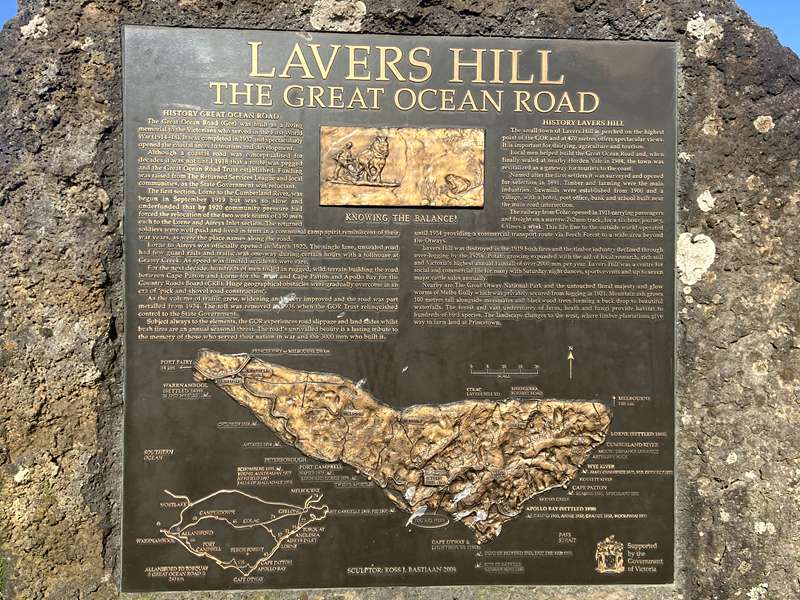
Located at the highest point of the Great Ocean Road, the plaque, located next to the ‘Drift’ sculpture, commemorates Lavers Hill’s timber heritage and the agricultural significance of the region.
LAVERS HILL, THE GREAT OCEAN ROAD
HISTORY GREAT OCEAN ROAD
The Great Ocean Road (GOR) was built as a living memorial to the Victorians who served in the First World War (1914-18). It was completed in 1932 and spectacularly opened the coastal areas to tourism and development.
Although a coastal road was conceptualised for decades it was not until 1918 that a route was pegged and the Great Ocean Road Trust established. Funding was raised from The Returned Services League and local communities, as the State Government was reluctant.
The first section, Lorne to the Cumberland River, was begun in September 1919 but was so slow and underfunded that by 1920 community pressure had forced the relocation of the two work teams of 150 men each to the Lorne and Aireys Inlet section. The returned soldiers were well paid and lived in tents in a communal camp spirit reminiscent of their war years, as were the place names along the road.
Lorne to Aireys was officially opened in March 1922. The single lane, unsealed road had few guard rails and traffic was one-way during certain hours with a tollhouse at Grassy Creek. As speed was limited accidents were rare.
For the next decade, hundreds of men toiled in rugged, wild terrain building the road between Cape Patton and Lorne for the Trust and Cape Patton and Apollo Bay for the Country Roads Board (CRB). Huge geographical obstacles were gradually overcome in an era of ‘pick and shovel road construction’.
As the volume of traffic grew, widening and safety improved and the road was part metalled from 1934. The toll was removed in 1936 when the GOR Trust relinquished control to the State Government.
Subject always to the elements, the GOR experiences road slippage and land slides whilst bush fires are an annual seasonal threat. The road’s unrivalled beauty is a lasting tribute to the memory of those who served their nation in war and the 3000 men who built it.
HISTORY LAVERS HILL
The small town of Lavers Hill is perched on the highest point of the GOR and at 470 metres offers spectacular views. It is important for dairying, agriculture and tourism.
Local men helped build the Great Ocean Road and, when finally sealed at nearby Horden Vale in 1984, the town was revitalized as a gateway for tourists to the coast.
Named after the first settlers it was surveyed and opened for selection in 1891. Timber and farming were the main industries. Sawmills were established from 1900 and a village, with a hotel, post office, bank and school built near the main road intersection.
The railway from Colac opened in 1911 carrying passengers and freight on a narrow 762mm track, for a six hour journey 6 times a week. This life line to the outside world operated until 1954 providing a commercial transport route via Beech Forest to a wide area beyond the Otways.
Lavers Hill was destroyed in the 1919 bush fires and the timber industry declined through over-logging by the 1920s. Potato growing expanded with the aid of local research, rich soil and Victoria’s highest annual rainfall of over 2000 mm per year. Lavers Hill was a centre for social and commercial life for many with Saturday night dances, sports events and up to seven major cattle sales annually.
Nearby are The Great Otway National Park and the untouched floral majesty and glow worms of Melba Gully which was privately secured from logging in 1921. Mountain ash grows 100 metres tall alongside messmates and blackwood trees forming a back drop to beautiful waterfalls. The forest and vast understorey of ferns, heath and fungi provide habitat to hundreds of bird species. The landscape changes to the west, where timber plantations give way to farm land at Princetown.
PORT CAMPBELL
Location: Port Campbell Foreshore, Cairns Street, Port Campbell.
.jpg)
PORT CAMPBELL, THE GREAT OCEAN ROAD
HISTORY GREAT OCEAN ROAD
The Great Ocean Road (GOR) was built as a living memorial to the Victorians who served in the First World War (1914-18). It was completed in 1932 and spectacularly opened the coastal areas to tourism and development.
Although a coastal road was conceptualised for decades it was not until 1918 that a route was pegged and the Great Ocean Road Trust established. Funding was raised from the Returned Services League and local communities, as the State Government was reluctant.
The first section, Lorne to the Cumberland River, was begun in September 1919 but was so slow and underfunded that by 1920 community pressure had forced the relocation of the two work teams of 150 men each to the Lorne and Aireys Inlet section. The returned soldiers were well paid and lived in tents, the place names along the road and the communal camp spirit were reminiscent of their war years.
Lorne to Aireys was officially opened in March 1922. The single lane, unsealed road had few guard rails and traffic was one-way during certain hours, with a tollhouse at Grassy Creek. As speed was limited accidents were rare.
For the next decade, hundreds of men toiled in rugged, wild terrain building the road between Cape Patton and Lorne for the Trust and Cape Patton and Apollo Bay for the Country Roads Board (CRB). Huge geographical obstacles were gradually overcome in an era of ‘pick and shovel road construction’.
As the volume of traffic grew, widening and safety improved and the road was part metalled from 1934. The toll was removed in 1936 when the GOR Trust relinquished control to the State Government.
Subject always to the elements, the GOR experiences road slippages and land slides whilst bush fires are an annual seasonal threat. The road’s unrivalled beauty is a lasting tribute to the many soldiers who served their nation in war and the 3000 men who built it.
Luttrell brothers at Port Campbell beach 1910. A coastal trading ketch is near the jetty which was built by 1880. Left are timber storage sheds including a shed in which emergency ship rescue equipment, including ‘land to sea’ rockets, was housed. Today’s small pier was built in 1938. Beyond a vastly isolated, hostile coastline.
HISTORY PORT CAMPBELL
The Aborigines originally called Port Campbell Purroitchihoorrong, meaning ‘the spirit voice that mocks you’, reputedly referring to the echo issuing from the headland’s sea caverns. It was later named after a local whaling captain.
European settlement began in the 1840s but the town remained isolated until a rough road was constructed in 1866. The town was surveyed in 1875, with public land auctions in 1878. The population of 138 hardy citizens built a post office in 1874, connected the telegraph by 1886 and telephone in 1909.
Fronting the treacherous Southern Ocean, the surrounding spectacular limestone cliffs made the bay a relatively safe haven from storms. A forty-metre T-shaped jetty was built to aid access for sea rescue and salvage following the 1878 wreck of the Loch Ard. It also provided a landing for the transport of goods to and produce from, this isolated area.
In 1892 the State railway ended 17 kilometres away at the town of Timboon, which prospered at the expense of Port Campbell. However tourism revitalised growth in the early 1900s with holiday-makers coming by train and then horse coach to the six guest houses and beach. For regional farmers the beach was a relaxing refuge from the endless toil of work and brutal summer heat.
Hardships of the 1930s Great Depression were eased by local employment on the Great Ocean Road between Princetown and Peterborough. This last section of the GOR was opened in Port Campbell in December 1935, but due to cavern undermining and the risk of collapse, the headland section closed in 2003.
In 1964 large tracts of the coastline were reserved as a National Park. The Great Ocean Road continues to inject new life into Port Campbell as a tourist destination.


