Tawonga - Climbing Mount Bogong


Victoria's Highest Mountain - The summit of Mount Bogong is 1986 metres above sea level. It is above the tree line and with the right conditions you feel like you're standing on top of the world.
Climbing Mount Bogong is strenuous and a high level of fitness is required. Sudden unexpected weather changes, including snow even in summer, can be experienced. You should expect the walk to take a full day, 6 - 10 hours, depending on your fitness level.
Where
There are several starting points to begin your walk to Mount Bogong. The best place to begin is the Mountain Creek Camping Area. This can be reached by sealed road from Tawonga approximately 12km along Mountain Creek Road. If you have a high clearance 4WD and are competent driving off-road, then it is sensible to drive to Camp Gap and walk up the Eskdale Spur. This saves about one and a half hours of walking time compared with The Staircase route. Granite Flat is another alternative but is not recommended because of it's isolation and the poor track conditions.
When
The best and safest time to do this walk is the Sunday of the March Labour Day Weekend. The Lions Club of Upper Kiewa Valley Inc. hold an annual Conquestathon - a strenuous activity suitable for those with a healthy level of fitness. Those that complete the event receive a medallion. The walk is possible in summer, early autumn and late spring however you must be prepared for all weather!
The Walk
Firstly study the maps, listen to the alpine areas weather forecast (92.5FM and on the board at the Mount Beauty Visitor Information Centre) and talk to the locals. From the Mountain Creek Camp Ground you have a choice of walking up Staircase or Eskdale Spur. The round trip on Eskdale Spur is 20kms, or 16kms return on Staircase Spur.
Do not rely on finding any drinking water once you start the climb. Take plenty with you.
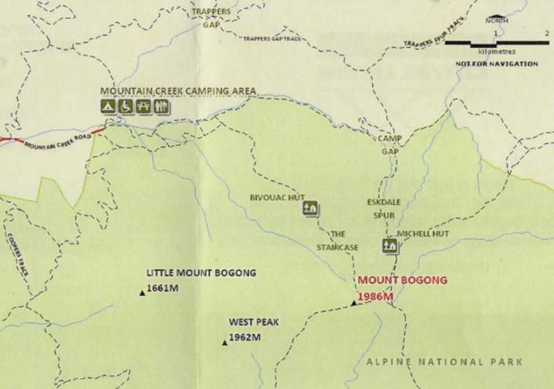
The Staircase
The track to the summit begins at the Camping Area and follows a vehicle track for approx. 2km, crossing bridges over the picturesque Mountain Creek. Even in a drought these streams, spring fed at the foot of Mount Bogong remarkably are still a ready supply of running water. About 1 km along this track there is a vehicle turning point and an Intentions Book. Please fill this in, and when you return mark that you have returned.
The beginning of Staircase (on your right) with an elevation of 700m, is marked with a sign into the bush. From here on, you walk in single file up hill!! You are amongst tall and majestic peppermint gums. This track was formerly known as Maddisons Track; it is the track once used by the Maddison family to drive their cattle onto the High Plains.
The walk follows the spur line until you reach Bivouac Hut at 1400m. Bivouac Hut offers a welcome resting place in a peaceful snow gum setting, which is approximately half way up the staircase spur. The original hut was destroyed by fire in 1970's. Continue climbing from the hut over some rocky outcrops, once you reach the tree line follow the line of snow poles past the ruins of the old Summit Hut. Take a breather and enjoy the magnificent views. You are now above the tree line.
Further along the track you will encounter the Gadsden Memorial Cairn. This commemorates the death of four walkers who perished at that spot in a blizzard in August 1943. A sobering thought and a reminder that the exposed treeless plain (alpine meadows) of the summit offers little shelter in poor weather.
Strong winds, fog, freezing temperatures, rain and snow are all common at this altitude. Navigation can be extremely difficult so turn back at the tree line if conditions are poor or deteriorating. At Pole 1278, near the tops turn right, it is less than 500m to the cairn marking the Summit. Many walkers symbolically place a stone on the cairn. Another 1-1 1/2hrs return walk to the West Peak and you can overlook the Kiewa Valley and the townships of Mount Beauty and Tawonga, weather permitting.
Eskdale Spur
If you are walking from Mountain Creek Camping Area, follow the track from the camp ground past the sign to The Staircase for approx. 5.5km to Camp Gap, elevation 1000m. The track climbs steeply up the Eskdale Spur crossing the headwaters of Mountain Creek only once before you reach Michells Hut (1600m). This new but replaces the old one burnt down in the 2003 fires. Continue up the track and just above the tree line follow the snow poles past the intersection with the Granite Flat Track, on your left continue up the spur to Pole 1278 and then to the summit.
In summer, if you 4WD to Camp Gap, follow the same route and commence the walk from there.
In winter, when this 4WD route is closed, you can drive to Trapper's Gap and follow the signs from there to Camp Gap to commence the walk. Although the 4WD track continues on past Camp Gap, the Eskdale Spur track starts only 50m along this track to the right. It is advisable to carry chains and the appropriate equipment to ensure you can get your vehicle in and out.
Return Trip
Most walkers prefer to come up the Staircase and down the Eskdale Spur. Which ever you choose don't forget to complete your entry in the Intentions Book. Allow the same time to walk down the mountain as up and allow sufficient time to ensure you arrive back before dark.
Take Care!!
Weather conditions can change rapidly in alpine areas. Snowfalls and blizzards can be experienced at any time of the year. Be prepared with:
Location
Mountain Creek Campground, Mountain Creek Road, Tawonga 3699 View Map


")