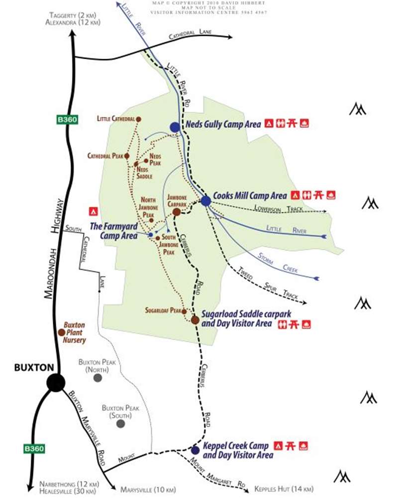
Taggerty - Cathedral Range State Park


The Cathedral Range is a spectacular seven kilometre rugged, rocky ridge of sharply upturned sedimentary rock.
A variety of walking tracks ranging in difficulty from easy to challenging offer the opportunity to explore the park's main features and climb the peaks to enjoy views of the forests and farmland in the valley below.
Enjoying the Park
The park is ideal for a relaxing picnic by the river bushwalking, rock climbing and camping.
Picnicking
Enjoy a picnic by Little River at Neds Gully or Cooks Mill camping areas.
Rock climbing
There are rock climbing areas available for all levels of ability from the beginners' area at The Boulders near Sugarloaf Saddle to the many challenging climbing routes on North Jawbone. For climbing information, please consult A Rock Climbers Guide to Eastern Victoria by the Victorian Climbing Club.
Camping
Camping is available at Cooks Mill with walk-in camping at Neds Gully and The Farmyard. Cooks Mill has sites suitable for a small number of caravans. Camping fees apply and a permit is required for Neds Gully, Cooks Mill and The Farmyard camping areas. Camping areas may become busy during holiday periods and long weekends.
Cycling
Cycling is permitted on public roads throughout the park. Cycling is not permitted on walking tracks and management vehicle tracks.
Walking
Walking tracks lead to all the major features of the park and range in difficulty from an easy stroll around the Friends Nature Trail to the challenging, steep and exposed Wells Cave Track.
Track grading
Hard: Steep difficult terrain with climbing and poor footing. Sturdy footwear and a good level of fitness required
Medium: Steep sections but footing less difficult. Sturdy footwear and a good level of fitness required
Easy: Moderately flat
Times quoted for walks are one way, at a moderate pace without allowing for rests, and are intended as a guide only.
Neds Gully Trailhead
TO COOKS MILL
Little River Track – 45 mins one way 2.7km Grade 3
This is a gentle 2.7km one-way winding track along Little River to Cooks Mill.
TO CATHEDRAL RANGE
Neds Gully Track - 1 hr one way 2.2km Grade 4
Starts near the camping area and leads up Neds Gully to Neds Saddle. This long, testing climb to Neds Saddle will make you realise that you aren't as fit as you thought. From Neds Saddle the tracks lead to Cathedral Peak, Little Cathedral, Neds Peak and The Farmyard.
Neds Peak Track - 15 mins one way 250m Grade 4
This is a short steep climb from Neds Saddle to Neds Peak. Please take note of the track markers at all times to remain on track, particularly on descent, as it can be easy to get lost here.
Cathedral Peak Track - 45 mins one way 650m Grade 4
This steep rocky climb rises steeply from Neds Saddle to eventually meet Ridge Track about 100m south of The Cathedral. There are superb views from the ridge to the summit, which isn't surprising given how steep the climb is. It is worth walking the extra distance to the summit of The Cathedral, the second highest point on the range.
Little Cathedral Track - 1 hr one way 1.2km Grade 4
Heading north from Neds Saddle, this rocky track leads to Ridge Track about 500m south of Little Cathedral Peak. Continue north along Ridge Track to the summit.
Ridge Track - 2 hrs one way 3.8km Grade 5
This challenging track is only suitable for experienced bushwalkers with a high level of fitness. Ridge Track follows the rocky ridgeline from The Farmyard to The Cathedral, North Cathedral and Little Cathedral, traversing numerous rocky exposed outcrops with great views. There is limited signage along the route.
Northern Circuit - 6 hrs 12.5km Grade 5
This circuit requires good fitness and an early start. Do not start this walk in the afternoon. Allow plenty of time, and carry plenty of water. Very difficult grade 5 tracks are included in this route; you need to be fully confident of your ability to complete these before starting. Please carefully read the descriptions of all the tracks involved in this circuit.
The Northern Circuit starts at Neds Gully and ascends to Neds Saddle via Neds Gully Track. From this saddle, the circuit takes Little Cathedral Track to meet Ridge Track. From this junction walkers can continue on to Little Cathedral (around 1km return) or head south over North Cathedral and The Cathedral to The Farmyard via Ridge Track. At The Farmyard, walkers descend the range via Jawbone Creek Track to Jawbone Carpark and St Bernards Track to Cooks Mill and Little River Track back to the circuit start at Neds Gully Camping Area. Cathedral Track, which connects Neds Saddle with Ridge Track about 200m south of The Cathedral, can be used to shorten the walk.
Cooks Mill Trailhead
Saint Bernards Track - 45 mins - Medium
This track starts at Cooks Mill and leads to Jawbone Carpark and Jawbone Creek Track.
Jawbone Trailhead
Jawbone Creek Track 1 hr - Medium
This track starts at Jawbone Carpark on Cerberus Road and climbs steeply to The Farmyard. The added challenge is to count the number of steps.
North Jawbone Track - 20 mins - Medium
This track branches from Jawbone Creek Track just below The Farmyard and leads to North Jawbone Peak.
Sugarloaf Trailhead
Razorback Track - 2 hrs - Hard
This track links The Farmyard to Sugarloaf Peak. It crosses exposed rocky outcrops. Look for markers to help you keep to the track.
Canyon Track - 30 mins - Hard
This track climbs from Sugarloaf Saddle Day Visitor Area to Sugarloaf Peak. Although not easy, it is less challenging than the Wells Cave approach.
South Jawbone Track - 10 min - Medium
Walk south through The Farmyard in the direction of Sugarloaf Peak. South Jawbone Track is signposted on the left and leads to South Jawbone Peak.
Wells Cave Track - 30 mins - Very Hard - Ascent only
This track climbs north from Sugarloaf Saddle Day Visitor Area to Sugarloaf Peak, the highest point on the range and is a challenging approach. Avoid this track if you are uncomfortable in high open and exposed places. Not recommended to carry backpacks or small children.
Messmate Track - 1.5hrs -Medium
This new track connects Sugarloaf Saddle Day Visitor Area to Cooks Mill Heritage Site and camping area via Tweed Spur Road.
Little River Track - 40 mins - Easy
This is an easy walk along the river between Neds Gully and Cooks Mill camping areas.
The Friends Nature Trail - 1 hr - Easy
This is an easy circuit walk through Manna Gum forest with scenic footbridges over Storm Creek and Little River. Follow the signs from Cooks Mill.
How to get there
From Melbourne follow the Maroondah Highway to Buxton towards Taggerty. Continue past Buxton for 9.5km and turn right into Cathedral Lane to find the park entrance 2.5km on your right.
Walker Safety
Walking on the range you are very exposed to the elements and conditions can vary from snow to extreme heat. Do not attempt any of these walks if the weather is extreme.
- Do not attempt any of these walks without sturdy footwear, adequate clothing, sufficient water (there is none available on the range) and a map, torch and phone. Phone signal is unreliable on some parts of the range.
- Although all tracks are marked with triangle markers, you will need to look for them at times, especially where the route crosses steep, rocky terrain, such as around Sugarloaf Peak, where the route includes unexpected turns, climbs and descents.
- Allow plenty of time. Do not begin any of the longer or more difficult Grade 5 walks in the late afternoon. Always allow more time than you think you will need.
- Most walks in the park are difficult and become more difficult the further you go. If you are struggling, do not continue, but turn back. Risk of injury is high and rescue times will be lengthy.
- The Sugarloaf area (The Canyon and Wells Cave Tracks) and Razorback Track are particularly difficult and include climbing steep, rock walls requiring the use of both hands and feet. If you're feeling unsure when you get to the first climb, remember that the further you go, the harder it gets. Wells Cave Track is only suitable for ascent. Please descend via Canyon Track. A fall will result in significant injury. The tracks in this area have seen many rescues, either lengthy stretcher carries by SES volunteers or lengthy and expensive extractions by the air ambulance helicopter. Do not attempt these routes if you are in any doubt as to your ability.
Review:
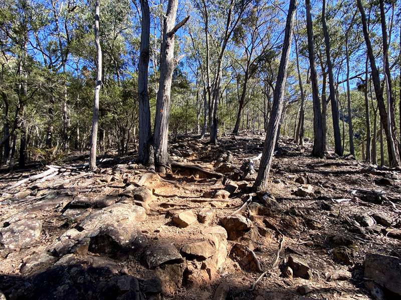
We did the Neds Gully Track which starts at the Neds Gully Trailhead which has a carpark, camping areas and toilets. Cross the bridge across the Little River and immediately turn left and follow the boardwalk until you reach the start of the Neds Gully Track. The track notes state "This walk will make you realise that you aren't as fit as you thought". This is totally apt. To get to Neds Saddle was a really tough walk up a steep and sustained rocky track through a boulder field. By the time we reached Neds Saddle we were wrecked and the chances of taking one of the walks to one of the peaks was absolute zero (or less). The walk back down was a lot easier than the walk up.
Location
Cathedral Lane, Taggerty 3714 View Map
Web Links
→ Cathedral Range State Park (Parks Victoria)
→ Cathedral Range State Park Map (PDF)
→ The Best Family Activities in the Yarra Valley
→ Cathedral Range State Park - Park Note (PDF)


")