Shepparton Natural Attractions Touring Route

Explore Greater Shepparton's natural attractions and places of interest by using these tools - you can take a self-guided touring route, or pick and choose points that interest you and explore at your leisure.
This guide is for visitors to follow as a self-guided touring route or to pick and choose points of interest to visit according to their own plans and time available.
This guide is designed for visitors to follow as a self-guided touring route, or to pick and choose points of interest according to their own plans and time available.
Guide:
Greater Shepparton Visitor Information Centre
33 Nixon Street, Shepparton (03) 5832 9330
Daily 9.00am- 5.00pm (excl. Christmas Day)
Meet the Visitor Experience Enthusiasts who will happily provide you with more detailed maps and tourism publications, tell you about changes to road conditions, operating times of businesses on this route and any special events happening during your visit.
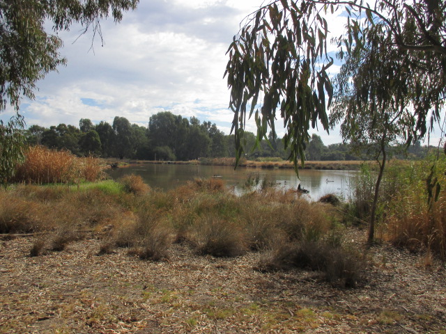
Victoria Park Lake
Wyndham Street, Shepparton
Victoria Park Lake is a tranquil, picturesque area, popular with visitors and locals for walking, cycling, picnics, fishing, bird watching and outdoor games. Through the years the Lake has been a focal point of community life. The precinct includes walking tracks, bike paths, skate park, table tennis, playgrounds and boating facilities. Adjacent is Aquamoves health and fitness centre with indoor and outdoor pools.
Goulburn River Shepparton
The Goulburn River is one of four Heritage Rivers in Victoria. The Broken River flows into the Goulburn in the heart of Shepparton. The floodplains and swamps between Shepparton and Mooroopna have great cultural significance and are integral to maintaining the rivers' health and supporting our community.
The Confluence
Only accessible along the shared path network (walk or cycle), the confluence is the point where the Broken River flows into the Goulburn River.
Dainton's Bridge
Midland Highway, Shepparton (South Side)
Named after the first engineer to build a bridge over the Goulburn River, James Henry Dainton, this site features a boat ramp, located on the southern side of the bridge. A fishing jetty is also accessible at this site when river levels are low. Good trailer parking is available on site.
Stuart Reserve
The Boulevard, Shepparton
A sealed loop track to the north or south of the playground along The Boulevard gives great access and views to the Goulburn River.
Jordan's Bend
The Boulevard, Shepparton
A good section of remnant vegetation in the heart of Shepparton which is home to the threatened Squirrel Glider. RiverConnect regularly conduct spotlight walks in this area.
Shepparton Weir - Fishway
The Boulevard, Shepparton
The weir was built to provide a reliable river height for urban water extraction. The newly created Fishway enables fish to move up and down stream, essentially using the Fishway as a ladder.
Goulburn & Broken River Access Map
Available from the Greater Shepparton Visitor Centre
This fold out map shows access points to the Goulburn & Broken Rivers in Shepparton Mooroopna and includes information about facilities and features at each point.
Lower Goulburn National Park
(Reedy Swamp)
Wanganui Road, Shepparton
The area stretching along the Goulburn River between Shepparton and Echuca was declared a National Park in 2008. The park is lined with River Red Gum (Eucalyptus camaldulensis) and forms an important wildlife corridor linking the mountains of the Great Dividing Range to the Murray River. Reedy Swamp provides an ideal location for bird spotting, particularly waterbirds, including the Glossy Ibis and the Royal Spoonbill.
Loch Garry
Loch Garry Road, Bunbartha
Wetlands and popular fishing area.
Barmah National Park
Nathalia and Barmah
Barmah National Park, together with the adjoining Millewa forest in New South Wales, forms the largest River Red Gum forest in the world. The complex ecology of the forest is closely linked to the Murray River and its flooding regime, creating a diverse natural habitat for a variety of wildlife, particularly waterbirds. Learn about the forest at the Nathalia Heritage Centre.
Kyabram Fauna Park
Lake Road, Kyabram
Phone: (03) 5832 2883
The Park has the second largest collection of Australian Fauna in Victoria, including Koalas, Alpine Dingoes, Owls, Snakes, Wombats, Kangaroos, Wallabies, Tasmanian Devils, Cockatoos, Parrots, Waterfowl, Cranes, Finches, Lizards and many more. There is a large Walk Thru Aviary; Australia's first energy efficient Reptile House, Wetland Viewing Hides and a Wetland Observation Tower.
Tatura -Transition Town
Tatura-Undera Road, Tatura
The township of Tatura is part of the global "Transition Network" which inspires, encourages, connects, supports and trains communities to self-organise around the Transition model, creating initiatives that rebuild resilience and reduce CO2 emissions.
Cussen Park
Tatura-Undera Road, Tatura
Cussen Park is a bushland style park encompassing 33 hectares of wetlands, woodlands and open space on the Northern outskirts of the town of Tatura. The land which forms Cussen Park is surrounded by industrial, residential and irrigated farm land. Cussen Park features constructed wetlands, bird hides, observation decks and well developed paths and signs allowing people to closely observe many bird species otherwise not possible. Experience the Hear & There Sound Walk - an innovative audio tour experience supported by interpretive signage that guides you through the wetland ecosystem.
Lake Bartlett
Service Street, Tatura
Lake Bartlett combines wetlands and an ornamental lake used for recreational purposes that provide habitat for wildlife and improving water quality.
Crouching Emu Trail
Dhurringile Road, Tatura
A project instigated by the Dhurringile and District Landcare group in partnership with local community groups and Greater Shepparton City Council, preserved threatened remaining stands of native Grey Box and Yellow Gum trees, Golden and Silver Wattles, and Wallaby and Spear grasses. Walking paths have been constructed along the length of the site.
Doctors Swamp Wildlife Reserve
Bendigo-Murchison Road, Murchison
A 200 hectare red gum swamp near Murchison. The wetland is considered to be one of the most intact red gum swamps in Victoria and supports a diverse range of native wetland plants and provides important habitat for waterbirds. The Doctors Swamp area is abundant with birdlife (over 60 species) and is situated along the Murchison Rail Trail.
Murchison Boardwalk
The boardwalk lets visitors to the area enjoy the impressive view of the Goulburn River, which was navigable by paddle steamers prior to 1887.
Gemmill Swamp Wildlife Reserve
Echuca Road, Mooroopna
Gemmill Swamp Wildlife Reserve covers an area of approximately 170 hectares of Goulburn River floodplain forest and wetland between the urban centres of Mooroopna and Shepparton. The Reserve includes Gemmill Swamp, a high conservation value wetland of State significance, and a surrounding area of relatively natural river red gum forest. Gemmill Swamp Wildlife Reserve is significant in a state wide context because it provides habitat for some of Victoria's rare and vulnerable mammals, birds and reptiles, including squirrel glider, turquoise parrots and superb parrots.
Shepparton Regional Park
Midland Highway, between Shepparton and Mooroopna
Home to the majestic River Red Gum Forest, Shepparton Regional Park is popular with locals and visitors alike. The parks access to the Goulburn River makes it a great spot for fishing and water sports. Cycling and walking are popular in this park which includes "The Flats" Aboriginal History Walk, a 4.3km loop with interpretive signage that highlights the significance of this area.
Australian Botanic Gardens Shepparton
Botanic Gardens Avenue, Kialla
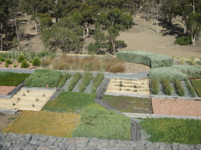
The Australian Botanic Gardens Shepparton uses Australian native plants in themed gardens designed to represent the cultural, environmental, historical and agricultural characteristics of Greater Shepparton and the Goulburn Valley. The Botanic Gardens are a long term project being developed over a number of years, on the former Kialla Tip site. The garden designs depict the story of change and the themes follow a timeline and are revealed to visitors as they walk along the pathways. Spectacular views from the top of "Honeysuckle Rise" include surrounding Goulburn River wetlands and the Strathbogie Ranges.
Mount Major
Mt Major-TV Road, Dookie
Walking and cycle access only. 6.4km. Magnificent views from atop Mt Major (381 metres) include surrounding canola fields in Spring, red volcanic soils, surrounding Dookie hills and further afield to Victoria's High Country. Mountain Bike trails are a popular feature here.
Dookie Rail Trail
Mary Street, Dookie
Walking and cycle access only. 9.3km return. This trail is set at the base of Mount Saddleback and takes in views of surrounding hills, as well as flora and fauna which may be spotted including echidnas, blue tongue lizards, kangaroos and even wedge tailed eagles.
Web Links
→ Many Great Things Publication - Natural Attractions (PDF)


")