Seaford Wetlands Circuit Walk

Seaford Wetlands Circuit is a 6.74 km walking trail around one of the largest remaining natural wetlands in the Port Phillip and Western Port region. The walk is ideal for birdwatching, enjoying nature and exploring an important wildlife habitat.
The wetlands cover approximately 180 hectares and support more than 190 recorded bird species, including migratory shorebirds, ducks, grebes, cormorants, herons and the threatened Australasian Bittern. The surrounding vegetation provides habitat for reptiles, frogs, eels and other native wildlife.
The mostly flat circuit follows shared walking and cycling paths, with a short unpaved section near Kananook Creek. Most of the walk is suitable for families, although the unpaved section may be unsuitable for some prams and wheelchairs.
Walk Details:
- Distance: 6.74 km circuit
- Time: Approximately 1 hour 40 minutes
- Difficulty: Easy, mostly flat
- Surface: Predominantly concrete shared paths, with a short unpaved section
- Best Time: October to March for migratory birdwatching
- Facilities: Picnic tables, seating, viewing platforms and shared walking/cycling paths
Seaford Wetlands Circuit Walk Map
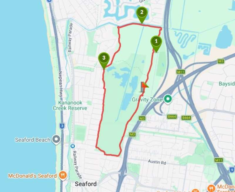
Interactive Map
Points of Interest
1. Downs Community Farm
Open every Saturday from 10am - 1pm, Downs Community Farm provides a communal gardening area, private veggie plots, and cooking/learning events for the community.
2. Creek trail
This unpaved part of the trail offers a scenic walk by the creek however may not be accessible for all.
3. Park bench
One of the handful of park benches found throughout the trail; it is a perfect spot to eat your lunch or sit and relax.
Walk Description:
Highlights include:
- Wetlands and Birdlife: Extensive reed beds, open water and mudflats provide habitat for resident and migratory birds
- Gananyu Bulukul Viewing Platform: A three-level accessible viewing platform near Austin Road offering panoramic views across the wetlands, with interpretive information about native flora and fauna
- Mona Street Lookout: A viewing point at the end of Mona Street
- Kananook Creek Bridge: A 36-metre pedestrian and cycling bridge completed in May 2024, improving connections around the wetlands
- Native Vegetation: River Red Gums, wetland vegetation and habitat for frogs, reptiles and other wildlife
- Downs Community Farm: Located near the trail, this community garden is a point of interest on the mapped circuit
Visitors can also extend their walk towards Kananook Creek Reserve or the Seaford Foreshore.
Access for Dogs:
Dogs are permitted on a lead and must remain on constructed pathways. Cats are prohibited from the reserve.
Location
14 Armstrongs Road, Seaford View Map
Web Links
→ Seaford Wetlands Trail (Walking Maps)
→ www.frankston.vic.gov.au/Things-To-Do/Parks-and-Reserves/Seaford/Seaford-Wetlands


