Sandy Point - Roy Henderson Path


The Roy Henderson Path starts at the beach end of Manuka Street (near Woodlands Avenue) and passes through a range of coastal vegetation before emerging at the edge of Shallow Inlet.
After crossing the road the path weaves through beautiful tea tree woodlands and new growth eucalypts, then into a forest of well established banksia trees.
Finally the path passes the tidal flats of Shallow Inlet with views towards the rolling Foster hills.
Be on the lookout for native wildlife and plenty of bird species along the way.
Distance: It takes approximately 45 minutes one way to complete the 2.3km path which is an easy walk.
Terrain: Easy, small incline. Gravel surface.
Access for Dogs:
Dogs permitted on leash along the walk. No horse are permitted.
At the beach at the end of the walk. No dogs on the beach 9am-6pm 1st December to 30th April. All other times dogs are allowed on leash.
Sandy Point Koalas
Beside the path is an area of eucalyptus trees which have been grown and the following information signs.
Sandy Point koalas live in the town and in the surrounding bush and farmland. Before Europeans arrived, our bush stretched around Waratah Bay and beyond, connecting to the Strzelecki Ranges. Koalas (and their genes!) could move and flow across the landscape. Land clearing and development have cut off these corridors.
A question of genes
Many koala populations across Victoria originate from a small number of koalas that were moved from French Island in the early 1900s. This has led to problems of low genetic diversity, ill-health and inbreeding in some areas.
However, the South Gippsland koalas, found in the Strzelecki ranges, are an original remnant population that hasn't been affected by the translocations. With their strong genetics, they are seen as very important for conservation of the species.
Genetic research by researchers from Federation University on the Sandy Point koalas tells us that our koalas most likely come from the original South Gippsland population. But, the Sandy Point koalas have now been isolated for a long time, so their gene pool is very narrow, which puts them at risk of future decline.
Did you know?
Koalas can sleep for up to 18 hours a day.
An adult koala eats 1/2-1kg of leaves each night.
A mother koala feeds her own poo to her offspring so it can gain the gut bacteria it needs to digest eucalypt leaves.
Koalas need trees
Our koalas' favourite food source is coast manna gum. They also sometimes shelter in other species, including banksia, sweet bursaria, coastal tea tree and swamp paperbark.
For decades, the Sandy Point community have been planting tree corridors both in the township and in the surrounding bush. These corridors are very important for koala food and habitat, and they give koalas and other wildlife safe areas to live in and move through - away from roads, cars and other threats.
Habitat loss is the greatest threat to koalas
The Australian Koala Foundation estimates that as a result of the loss of their habitat, around 4,000 koalas are killed each year by dogs and cars alone.
Review:
There is a little carpark at the intersection of Manuka Street and Woodlands Avenue.
A really pleasant walk through typical coastal vegetation which makes the track quite shady. There are a number of tables along the route.
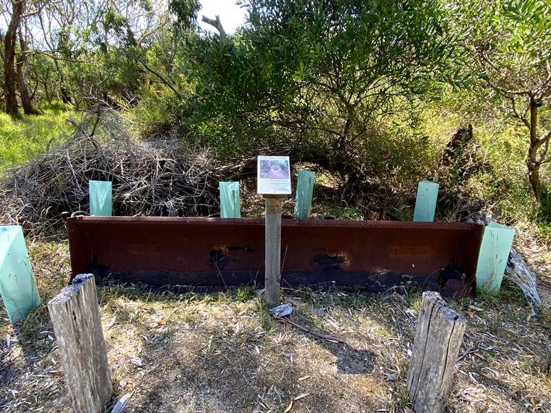
An interesting point along the walk is "The Tank Track". In the 1950's, Roy Henderson, who lived on this site, obtained a contract to construct the roads for the new Sandy Point Township, using a World War 2 Stuart army tank converted to a bulldozer. As there was only a single lane track from Shallow Inlet to site of the town, he constructed a second track to drive the tank on, to avoid meeting cars on the existing one. This track then became known locally as the "Tank Track". When the new Shallow Inlet road was constructed, this track was no longer used and became partially overgrown with vegetation. In 2008 the Sandy Point Foreshore Committee received a grant from the then Department of Sustainability and Environment to reopen this track (from the road crossing), as a walking/cycle path from the Sandy Point Township to Shallow Inlet. The bulldozer blade on this site is the one that was fitted to the army tank that was used to construct the original track.
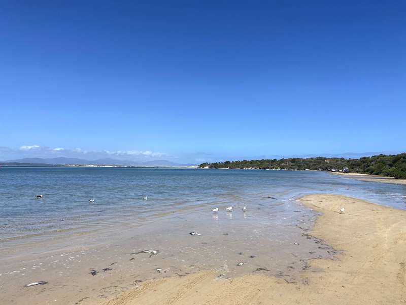
When you exit onto a road, there is a short walk along the road to the beautiful Shallow Inlet beach which has clear and shallow water. A number of people were driving onto the beach (when the tide was low) and launching their boats at the Sandy Point Boat Launching Area further down the beach.
Photos:
Location
15 Manuka Street, Sandy Point 3959 View Map
Web Links
→ Shallow Inlet to Sandy Point Beach (Walking Maps)


")