Rye Beach


Rye Beach has a very popular and always full summer camping reserve while the Jetty area attracts day visitors.
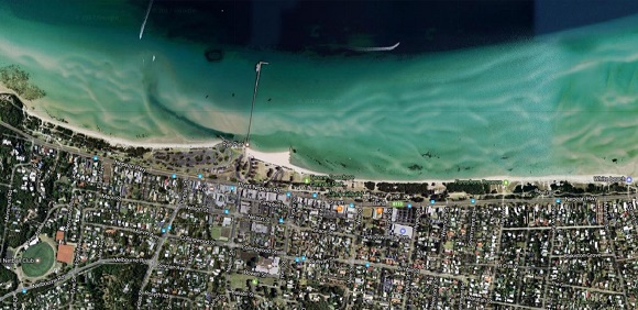
Rye Beach begins at White Cliffs and runs past the 300 m long Rye Jetty, almost due east for 4 km. A foreshore reserve backs the entire beach which, beside the popular jetty, has two boat ramps, a yacht club and a camping reserve. The beach is backed by the low reserve and fronted by shallow sand flats that are between 300 and 400 m wide. The narrowest flats are found at the jetty. They are covered at high tide, but exposed at low. Waves are usually low and only exceed a few decimetres during strong northerly winds.
Swimming - Usually a safe beach close inshore. Depth varies over the flats with the tide and deep water lies off the end of the flats. Do not jump or dive off the jetty as the water is very shallow.
Rye beach has a General Beach Hazard Rating of 1/10 (Least hazardous). It is not patrolled.
Review:
Much of the beach is next to Foreshore Camping areas. The best place to swim is to the east of the Rye pier which has the biggest beach in the area and is shallow for a long way out. There is also a nice playground here and the Octopus' Garden snorkelling area. There are also a lot of food shops near the Pier. Take a look at the Rye Lime Kiln for a historical insight into the area.
The east end of the beach is around the Tootgarook boat ramp where the beach is narrow and has some wooden groynes (barriers) to stop sand erosion. The Capel Sound Foreshore Camping area extends from here to the west as far as Shirlow Avenue.
Sailboarding is allowed to the west of here (Shirlow Avenue). The beach here is reasonably wide and sandy and goes out a fair distance with sandflats.
At Rye here there is the nice Rye's Up! Community Playground. At the playground there are toilets, water tap, grassy area, shelter with seats, picnic tables, shaded BBQs and unshaded tables.
There is also the Rye Pier Snorkelling Trail (Octopus' Garden) where you can discover an underwater world of plants and fish by exploring an 200m long underwater trail that leads along under Rye Pier.
100m east of Rye Pier is a rock groyne (rockwall) and further east of the groyne the beach is fairly narrow. However, between the groyne and pier the beach is very wide and sandy and no boats are allowed in this area. The pier is very long and worth a stroll along it.
There is paid parking near the pier from 8am to 8pm from November 1 to April 30 inclusive. Note that you cannot pay by cash.
To the west of the pier is a 40 m long section of beach next to a boat ramp and small jetty and then a beach which curves around to a point where there is a seawall.
At West Rye beach there is some free parking, boat trailer parking and a decent sandy beach backed by fairly wide sand dunes. This area is the Rye Beach Foreshore Camping Ground. The west end of the beach is rocky and has a sea-wall and ends at White Cliffs.
Steps lead up the White Cliffs to a good vantage point and there is a track down to an area with some unshaded tables, water tap and Rye Lime Kiln. This reconstructed kiln is a memorial to one of the earliest industries on the Peninsula and a tribute to the early settlers and their rugged enterprise. During the mid 1800's natural limestone was mined and burnt in kilns to produce lime for making mortar. Most of the lime was loaded in barges and shipped to Melbourne for use in the building industry. The last commercial burning of line on the Peninsula was carried out in the Rye area.
Limestone is a sedimentary rock which was formed by the slightly acid rainwater through the porous dunes and dissolved sea shells. Lime would be loaded onto wagons and drawn by bullocks to the beach and into shallow water. In Melbourne the vessels unloaded at Queens Wharf with a special limecraft dock being constructed near King Street in 1849.
The production process involved kindling and brush at the bottom, then heavier wood, followed by limestone and wood alternately to the top. The limeburners found the Sheoak and Banksia ideal for use in the kilns and it was not long before the Peninsula was stripped of such timber.
Access for Dogs:
Dogs are prohibited on the beach between 9am and 7pm during Daylight Savings Period. At other times of the day (7pm - 9am), dogs are permitted leash free. Dogs must immediately be brought under effective control if it threatens or annoys any person or animal. The "leash-free" beach does NOT include vegetated parts of the foreshore reserve.
Map:
Photos:
Location
2385 Point Nepean Road, Rye 3941 View Map
Web Links
→ Rye Beach (BeachSafe)


")