Rubicon Heritage Walk

The Rubicon Heritage Walk is a spectacular 3.9 km loop walk. It winds through lush Mountain Ash - the tallest flowering tree in the world - and down into cool temperate rainforests of ancient myrtle beech trees.
The Rubicon Valley Historic and Cultural Features Reserve was set aside to protect the area's historic sites and values. Timber harvesting used to be the major industry of the region, beginning in the early 1900s. There were eight sawmills operating in the forest in the first half of the century.
The Rubicon Heritage Walk invites you to explore the heritage heartland of the Rubicon forests. Travel past the sites of the first two timber mills built in the Rubicon back in 1907 and 1910. What remained of both mills was burnt during the 1939 fires. Forest has regrown on the old mill sites making them difficult to find. The Royston Power Station and hydro power infrastructure survived both the 1939 and 2009 bushfires and remains in operation today.
How to get there
From Melbourne, follow the Maroondah Highway; turn right onto the Taggerty-Thornton Road and right again onto Rubicon Road. Once you drive past the bridge over the Rubicon River, the road name changes to Royston Road. Continue along Royston Road for a further 5.7km to the carpark at the start of the walk. Note - this carpark is the starting point for of the Rubicon Dam Walk also. Suitable for 2WD vehicles.
The co-ordinates of the start point of the walk are: -37.3681958,145.8696466
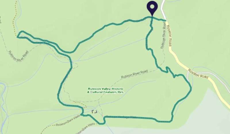
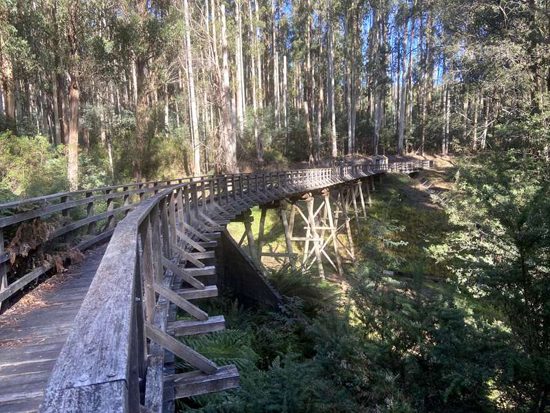
Highlights of the walk include crossing an impressive timber trestle bridge, a look inside a small heritage-listed sawmill and walking along the aqueduct that feeds the Royston Power Station.
Walk Landmarks ...
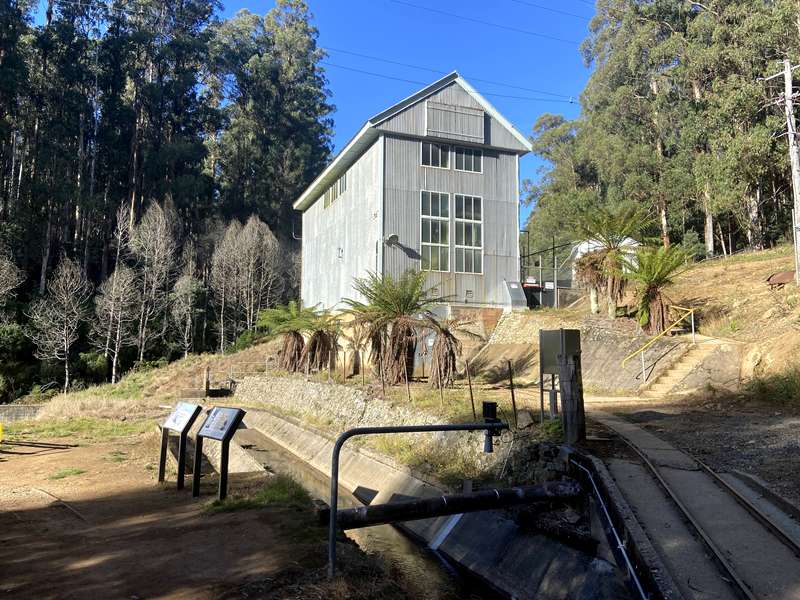
1. From the carpark the track leads through tall Mountain Ash forest. After 100m the track turns left and continues for another 650m to the Royston aqueduct. Meander through forest regenerating in the wake of the 2009 fires that swept through this area. Turn right at the aqueduct and walk 800m along the aqueduct to the Royston forebay (a reservoir supplying water to turbines which ensures a consistent and controlled flow) at the top of the Royston penstock (timber pipeline).
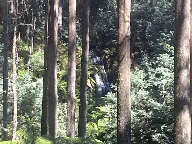
Before you reach the Royston forebay, you'll hear the sound of a waterfall where water from the forebay discharge aqueduct tumbles down a vertical section. There is one place along the track where you can see the falls.
2. Follow the old timber pipeline (penstock) down to the Royston Power Station.
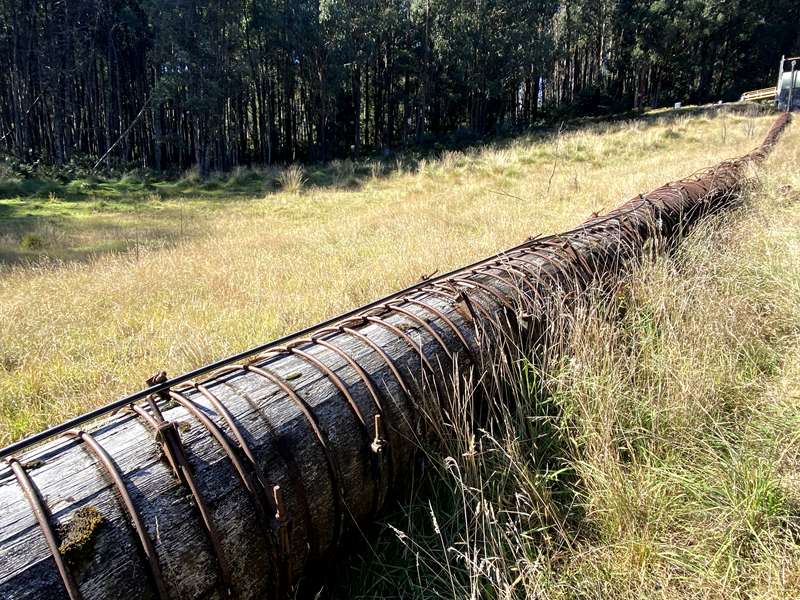
Explore this fascinating heritage asset noting the changes in materials and enjoying the views across the valley of the mountain forests. The penstock delivers the water from the Royston River Valley catchments above and uses gravity to drive the turbines of the Royston Power Station below.
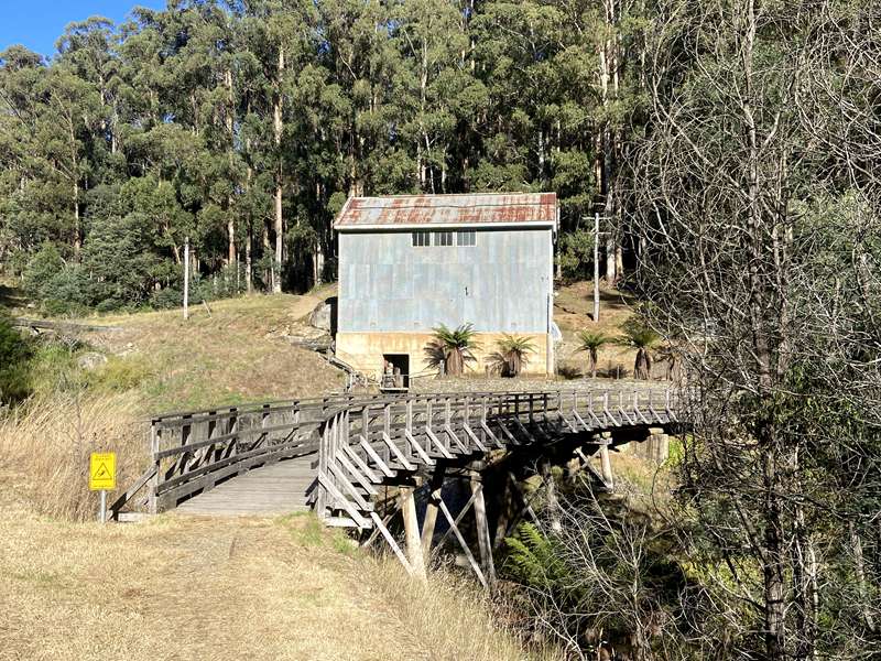
3. The Royston Power Station precinct makes an ideal place for a short break. This fully automated hydro power station became operational in 1928. It continues to be an integral part of the Victorian power grid today. There is no access into the building.
From here you have the option to extend the walk by turning left and following the aqueduct for 4km (one way) to the Rubicon Dam weir.
4. Beyond the Power Station head over the Royston trestle bridge and follow the aqueduct alignment for 200m to the old Rubicon timber mill.
5. Look around inside this small mill that was built after the 1939 bushfires. It provided on-site timber supplies for the State Electricity Commission employees involved in rebuilding trestle bridges and other fire-damaged infrastructure.

6. From the old sawmill continue for 250m along the aqueduct to the 15,000 siphon trestle bridge.
7. The 15,000 siphon trestle bridge is located 15,000 feet or 5km - along the aqueduct as measured from the top of the drop down into the Rubicon Power Station.
Follow the aqueduct for 400m to the small aqueduct crossing, then leave the aqueduct and head into the forest.
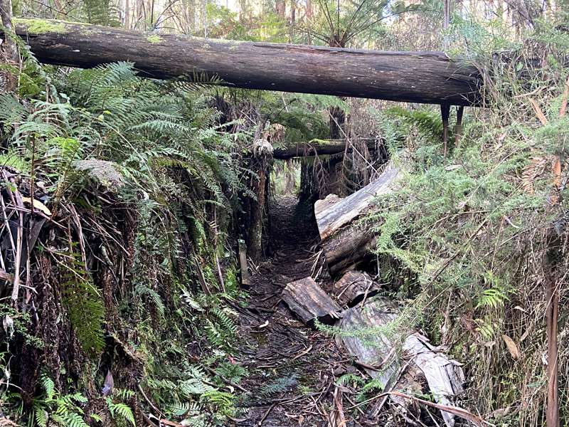
8. The track through the forest back to the car park uses part of the alignment of the aqueduct that powered Clark and Pearce No. 1 mill and part of a timber tramway. A network of timber tramways transported logs and timber from the remote forest mills to the main tramway heading out of the forest.
Overall, the walk has occasional steps, short steep hills, formed track and clearly sign posted. Bushwalking experience is recommended.
You can extend the walk by continuing on to the Rubicon Dam on the Rubicon Dam Walk.
Access for Dogs:
Dogs allowed
Review:
A wonderful walk which has many natural and historical highlights.
We didn't have any phone coverage during the walk. The walk is well sign-posted and there is a sign post at all key points. Look out for the white arrows on a green background. One confusing aspect is that the same coloured signage is used for both the Rubicon Heritage Walk and Rubicon Dam Loop. We inadvertently got onto the Rubicon Dam Loop rather than stay on the Rubicon Heritage Walk. The key factor to stay on the Heritage Walk is to cross the trestle bridge at the Royston Power Station and do not continue on the bush track past the Power Station.
Rubicon State Forest History
The area is home to the Taungurung people. Evidence of indigenous habitation exists throughout the forest, such as artefact scatters and scar trees.
The Rubicon Valley Historic Area has been set aside for the protection of the area's historic sites and values. Timber harvesting was historically the major industry of the region, beginning in the early 1900's. Eight sawmills were operating in the Rubicon forest in the first half of the century.
A network of wooden tramways connected the sawmills to the edge of the forest. A 2ft gauge steel tramway connecting Rubicon Forest to the township of Alexandra carried the sawn timber by steam engine, then in 1935, by diesel engine. These two diesel engines, the first Victorian built diesel locomotives, have been restored and are in operation at the Alexandra Timber Tramway and Museum.
The Historic Area is the site of the first Victorian hydro-electric power scheme. The Rubicon scheme, completed in 1929, consists of four power stations and associated dams, aqueducts and pipelines. During the 1930's, the scheme contributed about one-fifth of Victoria's electricity needs. While still in operation today, its contribution to meeting the State's energy needs is now small.
A 1.3 km haulage, with an average grade of 1 in 3, from the Rubicon Power Station to the top of the spur, still exists today. A steel tramway used to maintain the aqueduct between the Rubicon Power Station and the Rubicon Dam was in operation until the mid 1990's when All Terrain Vehicles (ATV) took over the work of the tramcars. Three impressive trestle bridges form part of the tramway at Lubra Creek, Beech. Creek and at the Fifteen Thousand Foot Siphon. A fourth trestle bridge is located at Royston Power Station. While still in operation today, public access to the power stations and associated infrastructure is not permitted.
The 15000" Siphon trestle bridge, named because of its distance in feet from the beginning of the tramline at the top of the haulage, has been reconstructed to original specifications.
The entire hydro-electric scheme has been added to the Victorian Heritage Register along with many of the former mill sites and associated tramways which are still apparent in the forest today.
Severe fires in 1939 destroyed a large part of the forest, its sawmills and associated tramways. Some sawmills and tramways were reconstructed to salvage the fire-killed timber. Damage to the hydro-electricity scheme was largely restricted to the steel tramway adjacent to the Rubicon aqueduct that had badly buckled from the heat and sections of wooden-stave pipes and power lines. Twelve men lost their lives in the Rubicon forest during the 1939 fires. The area was again damaged by fire in 2009 destroying the Beech Creek Trestle Bridge. The bridge has since been rebuilt.
Photos:
Location
Royston Road, Rubicon 3712 View Map
Web Links
→ www.exploreoutdoors.vic.gov.au/activities/walking-in-victoria/rubicon-heritage-and-dam-walk


")