Rockbank and Kororoit Creek Heritage Trail (Aintree)

.jpg "Rockbank and Kororoit Creek Heritage Trail (Aintree)")
The heritage trail is held on the traditional lands of the Wurundjeri Woi-wurrung peoples of the Kulin nation. The trail is marked by signs in the path labelled "Rockbank Heritage Trail".
Rockbank and Kororoit Creek Heritage Trail Map
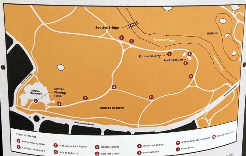
1. Aintree Viewing Tower
From stone tool manufacturing to a rest stop on the way to the Goldfields, this wider area is home to conflicting histories of innovation, loss and settlement. To find out more, follow the path and dig into your imagination.
2. A Cultural Landscape
The land you stand on today has been the traditional home of the Kurunjang clan of the Wurundjeri Woi-wurrung peoples of the Kulin nation for millennia. Fed by the Kororoit Creek to the north, this once flourishing landscape provided fresh water, pant and animal resources to sustain life, and in turn, the habitat thrived from centuries of continual care by the Wurundjeri Woi-wurrung. While the area was transformed during European colonialism, remnants of the former landscape remain. Keep moving along the trail to discover the rich cultural activities that once took place here.
3. A Resource Rich Region
This area was once awash with a range of plant and animal resources that were central to the traditional lifestyles of local Wurundjeri Woi-wurrung peoples.
While most native vegetation along the volcanic plains was cleared by colonisers during the nineteenth century, pockets of remnant woodland have survived in this area. Examples include the River Red Gums at the Leakes Road Woodland Reserve, which would have provided bark to make canoes and shields, or the plain grasslands near the Kororoit Creek, which would have attracted animals like possums, kangaroos, snakes and lizards for hunting. These varied uses not only reflect the diversity of natural resources in this area, but also illustrate an intimate understanding of the local landscape. Today, kangaroos continue to congregate around the tall grasses near Kororoit Creek.
4. A Site of Industry
For thousands of years, the Wurundjeri Woi-wurrung survived and thrived in this area by skilfully manufacturing stone tools through their deep knowledge of geology and geomorphology.
In 2016, thousands of stone tool artefacts dating back at least 8,000 years were recovered on elevated land overlooking the creek. Used to grind stone, process grass seeds and as barbs on hunting spears, these tools reflect the wide range of day-to-day gathering, production and hunting activities that took place in this area, particularly along the resource rich creek.
Crafting these tools was no simple task, and consisted of striking stone at specific angles, as well as further trimming using sharp instruments.
5. Beattys Bridge - A Vital Colonial Crossing
-embed01.jpg)
While you cannot cross it now, the remnants of this timber road bridge, better known as Beattys Bridge, once formed a vital crossing over Kororoit Creek. Although the creek was a spiritual and life source to the Wurundjeri Woi-wurrung, it proved a barrier to Europeans who wanted to traverse it.
Named after the Beatty family, who owned the nearby Rockbank Inn, the bridge was part of a major overland route between Melbourne and Ballarat. It was built in 1893 and replaced an earlier 1860 road bridge that facilitated travel between Melbourne and Ballarat goldfields during the Victorian gold rush. Beattys Bridge was also used as a crossing point for weary travellers looking to reach Rockbank Inn for a refreshment. If you look closely, you can still see some of the original bluestone road surface cobbling on the pavement leading south from the bridge to the Inn ruins.
6. Kororoit Creek - Water as Lifeblood
Bunjil, the wedge-tailed eagle, flew over the land and dropped a snake to form Kororoit Creek... ~ The Dreaming
Kororoit Creek is a key feature in the landscape, slicing and snaking north to south across the volcanic plain. This creek provided fresh drinking water, nurtured a diverse range of plants that were used as food sources, medicines and raw materials, and also acted as an important transit route for groups travelling from the bay and into the hinterland towards Sunbury.
As a life source, land along the creek was a site of repeated use and occupation. The Kororoit Creek remains a deeply spiritual site to Traditional Owners, and holds important Dreamtime creation stories that are integral to their culture.
7. Bluestone Quarry - A Site of Sweat & Stone
It is 1852, you're exhausted, aching and covered in beads of sweat, yet all you can do is concentrate on the steady, rhythmic sounds of your hammer hitting the stone quarry.
Bluestone, otherwise known as basalt rock, was quarried from this site and used to build Rockbank Inn, yet, extracting it was no easy feat. Formed from volcanic eruptions, bluestone is famed for being one of the most hard and durable building materials. Working the stone required great skill, physical labour and perseverance, particularly during a period in which quarrying largely relied on manual tools. For a smaller quarry like this one, stone blocks would have been mined by inserting iron wedges into natural cracks in the stone, which were then struck with a hammer until the stone split apart.
8. Rockbank Inn - Gold, Glorious Gold!
-embed02.jpg)
You're travelling cross-country in search of a fortune. Flocking with the crowds to the Ballarat gold fields, 1853 will be the year you strike it rich!
But for now, your boots are pinching. Footsore and thirsty, you stumble along the road to the new hotel by the river. The scent of hearth smoke and food drifts in the wind, set-ting your stomach rumbling.
The Rockbank Hotel offers "... good beds, and every attention to cleanliness and comfort... the very best qualities of wines, spirits and ales; and substantial meals (The Argus, 8 September 1853). Unfortunately, the small inn doesn't have much accommodation space as it is actually a reused homestead. But there is a spot to raise a tent by the river crossing.
The original homestead-turned-hotel lies to your right. Increasing gold-seeker traffic meant more income and when the larger, newer Inn to the left was built in 1856, the original hotel was used for extra accommodation and storage.
Dubious Refreshments
We halted for a short time on the borders of a beautiful creek, near which is the posting house for coaches running to Ballarat. In the hotel, a sour, squashy, disagreeable drink, yclept colonial beer, is retailed at one shilling the quart; ale or porter, three shillings a bottle; and soi-disant wines and spirits at one shilling per nobbler (Stoney 1856, 2) - nobbler (pl. nobblers):
(Australia, obsolete) A serving of beer or spirits.
Sharp ringing sounds emanate from the nearby quarry. Blocks of basalt are lifted into place, extending the old hotel out to increase capacity. The larger, newer Inn dominates the rise and overlooks the cobblestone road leading to the Kororoit Creek crossing.
The hotel saw many visitors throughout its life. Famously, on their way to subdue dissenting miners during the Eureka Rebellion in 1854, Major-General Sir Robert Nickle and members of the 12th and 40th regiments of the British army stopped off at the original, smaller Rockbank Hotel for some dubious refreshments.
By 1856, increased traffic along the Melbourne-Ballarat Road generated enough income for the Rockbank Hotel to expand. The larger ruins in front of you became the Rockbank Inn, serving many more travellers before eventually serving as a home to the Beatty family from 1870 until the 1950s.
9. Archaeological Excavations - Investigating the Inn
-embed03.jpg)
In 2021, an archaeological excavation took place within Rockbank Inn and its outbuildings to uncover further information about the use of the Inn during the Victorian gold rush, as well as the site's use as an overland route to the goldfields. Archaeologists excavated the interior of this larger Inn building, discovering a range of nineteenth and twentieth century artefacts related to its use as both an Inn and a homestead.
Artefacts included pottery, small personal items such as buttons and clay pipes, and bones discarded by the patrons of the Inn and later the Beatty family. They also uncovered remnant parts of the structure, such as the preserved floorboards and floor joists. Importantly, these findings help us to better understand the experience of travel and roadside hospitality during the Victorian gold rush, and also provides us with more information about the site's later use as a farm homestead by the Beatty family.
Piecing Together History
-embed04.jpg)
Constructed by William Yuille in 1852, this smaller, reused homestead was not large enough to house large numbers of travellers - it is likely that refreshments and food were served within this bluestone building, and travellers camped downhill from the hotel in the vicinity of the creek. Excavations of this smaller homestead-turned-hotel in 2021 uncovered layers of building fabric, indicating that there were several phases associated with this development. These layers suggest that the structure was re-modelled when it was converted from a homestead to a hotel.
Archaeologists also uncovered the impressions of wooden floor joists, which once would have supported floorboards within the rooms of the building. These uncovered layers of historical fabric not only provide insight into the changing use of the building over time, but also illustrate how the site was deeply shaped by events taking place during the early years of the Victorian gold rush.
10. Laying Stone Roads
Sweeping around the stony rise, the road to Rockbank Hotel and Beattys Bridge invites weary travellers onwards. The basalt cobbles, quarried from nearby, keep the dirt from your shoes but make riding in a cart very bumpy!
The Victorian gold rush created a huge boom in Victoria throughout the 1850's-1860's. The incredible influx of miners and migrants moving across the State created investment opportunities that could not be ignored. When the Rockbank Hotel was opened in 1853 and expanded to become Rockbank Inn due to demand, stone roads prevented many travellers from getting bogged down in the mud.
11. Ongoing Connections - An Enduring Connection
From Wurundjeri stone manufacturing to colonial homesteads, this area is home to multi-layered histories of innovation, loss and settlement. It is necessary to note that the changes imposed on the landscape in the service of European settlement brought about substantial losses for Traditional Owners through land displacement.
Ultimately, the enduring spiritual connections the Wurundjeri Woi-wurrung have to the area in the face of extreme adversity are a testament to their fierce resistance to the invasion of their land.
Photos:
Location
25 Aintree Boulevard, Aintree 3336 View Map


")