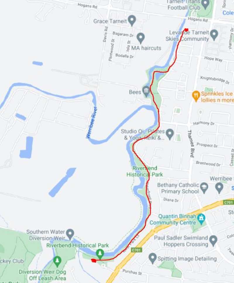
Riverbend Historical Park to Davis Creek Walk (Tarneit)

.jpg "Riverbend Historical Park to Davis Creek Walk (Tarneit)")
Follow the bends of the Werribee River past ancient redgums to the Davis Creek confluence and wetlands. This walk is 3km each way.
This walk starts in picturesque Riverbend Historical Park. There is an entry road off Heaths Road opposite Purchas Street, Werribee.
The walk offers many attractive spots for people to enjoy the beauty of the Werribee River. Each river bend has a unique character. Ancient River Redgums and a healthy understory provide habitat for native birdlife, reptile and insects.
The path leads to the confluence of Davis Creek and then follows the creek north to Tarneit. Davis Creek Wetland has billabongs that fluctuate with seasonal rainfall and provide a home to many creatures including the Growling Grass Frog.
Toilets and drinking water are not available on this walk.
Route Map:
Access for Dogs:
Dogs are permitted on lead.
Information Signage
Werribee Irrigation Colony
The Chaffey brothers, George and William, came to Australia from America in 1886. They set up the Werribee Irrigation Colony to irrigate 1468 acres of land between Sayers, Tarneit and Shaws Roads.
A pumping plant was erected, 900 metres south of Sayers Road with a steam engine driven pump that could lift up to 7000 litres of water per minute.
In the first year of operation (1889-90), there was insufficient water flow to provide for the irrigation scheme and the Werribee township's water supply. In a effort to reduce water loss through the open channels, the pump and infrastructure were moved closer to the farms reducing the open channels by about 6km.
The irrigation Colony collapsed by 1892. In recognition of this early development, Council has a Ward named 'Chaffey'.
The Chaffey Irrigation Pump
-embed02.jpg)
This site was the second location of the steam engine driven pump of the Chaffey Irrigation Colony.
The pump, capable of delivering up to 7,000 litres per minute, was originally installed on the Werribee River, 900 metres south of Sayers Road, and supplied water via an open channel to the irrigation area.
In the first year of operation, during the summer of 1889-90, there was insufficient water flow in the river to provide for both the irrigation scheme and the Werribee township water supply.
In an effort to reduce water loss through seepage and evaporation from the channels, the pump, along with its boiler and steam engine were moved to this site. The reservoir constructed across Davis Creek supplied water to prime the Chaffey pump. Around 1940-50 the reservoir wall was raised in height to increase capacity for local market gardens.
Golden Fleece Inn
The Main track from Melbourne to Geelong in use in 1836 crossed the Werribee River about 2.4 kilometres from the present Werribee CBD in the vicinity of Shaw's bridge on Heaths Road.
Situated on the east bank of the Werribee River, an inn was built at the northern end of Waterfront Boulevard, originally named the 'Half-Way House', it was reopened in 1838 by Robert W Lyall and renamed the 'Golden Fleece Inn', remained the customary half way stopping place for people travelling between Melbourne and Geelong.
This stand of English Elm (Ulmus procera) were researched in 2011 by local Heritage Tree Researcher, Mr Charlie Buttigieg, as possibly the earliest planting of their type in Victoria. It is suspected that these trees were planted at the inn during its period of operation. If so the trees will rate State Significance as the inn closed before the establishment of the Royal Botanic Gardens which claim to have the earliest English Eims in Victoria.
Review:
A nice walk along footpaths beside the Werribee River which is suitable for prams (and and shared with cyclists). There are plenty of seats along the trail for a rest.
At Riverbend Historical Park there is a carpark, picnic area with four unshaded tables, BBQs, old farm equipment, bins and canoe launching deck.
-embed01.jpg)
An upgrade is planned during late 2026 which includes these proposed improvements:
- Picnic area upgrade, including new shelters, BBQs and seating
- New accessible public toilet and drinking fountain
- New pedestrian path linking the carpark to the Werribee River Trail
- New pedestrian steps down to Melbourne Water's proposed floating pontoon
Part way along the route is a lookout platform (without a view of the water) with a bin. Further on, the path passes some ponds.
At the confluence of the Werribee River and Davis Creek is a big grassy area, two unshaded tables, bin, simple playground and historic pumping shed.
-embed03.jpg)
The route continues past a wetlands area with lots of croaking frogs. Return back when Riversdale Drive turns to the east.
Photos:
Location
500 Purchas Street, Werribee 3030 View Map
Web Links
→ Riverbend Park to Davis Creek, Tarneit (Walking Maps)


")