Pyrenees Rail Heritage Trail


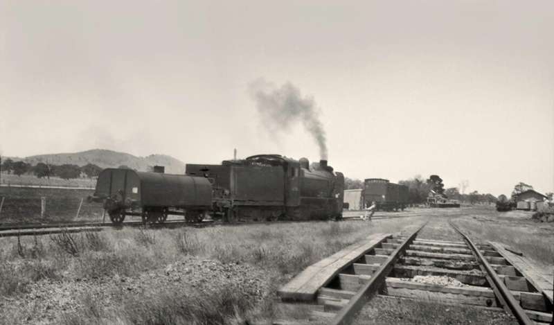
The Pyrenees Rail Heritage Trail is a self-guided driving circuit exploring the former railway stations, sidings and communities once connected by rail through the Pyrenees region.
Seven large interpretive signs have been installed near former railway-station sites at Amphitheatre, Elmhurst, Crowlands, Joel, Landsborough West, Tulkara and Navarre. The signs explain how the railways supported timber cutting, sawmilling, farming, passenger transport and local trade.
The trail was developed by the Landsborough & District Historical Group with support from Pyrenees Shire Council and Pacific Blue.
Despite its name, this is not a continuous walking or cycling rail trail. It is a motor-vehicle touring circuit using public roads between geographically separated heritage sites.
Distance: No complete official circuit distance is published
Time: Allow at least half a day; no official duration is published
Route: Self-drive circuit beginning and ending at Avoca
Direction: Can be completed clockwise or anticlockwise
Terrain: Town streets and rural roads with surfaces and conditions that may vary
Accessibility: No official accessibility grade has been published
Important Route Information:
Download the official map and directions before leaving Avoca. Several stops are in sparsely populated rural areas where mobile-phone coverage and visitor facilities may be limited.
The railway stations and most associated buildings no longer survive. The interpretive signs are positioned near the former station sites, and visitors should remain on public roads, reserves and marked access areas.
Pyrenees Rail Heritage Trail Maps
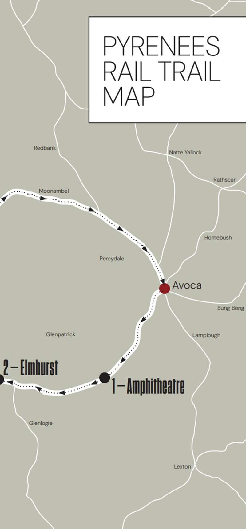
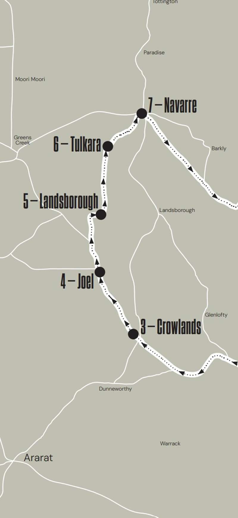
Pyrenees Rail Heritage Trail:
1. Amphitheatre
Travel approximately 13 km west from Avoca along the Pyrenees Highway. Turn into School Street and enter Amphitheatre Recreation Reserve. The interpretive sign is towards the rear of the reserve near the school grounds.
Amphitheatre railway station opened with the Avoca-Ararat line on 18 November 1890. Timber traffic was initially extensive, with as many as four trains each week loaded at the siding during its busiest period.
Passenger services ended in 1957 and the station closed to all traffic when the line closed on 8 July 1959. Its portable station building, goods shed and other facilities were subsequently removed.
Sign location: Amphitheatre Recreation Reserve, 9 School Street, Amphitheatre VIC 3468
2. Elmhurst
Continue approximately 15 km along the Pyrenees Highway and turn right into Green Street at Elmhurst. The sign stands near the former railway-station site.
Elmhurst station also opened on 18 November 1890 and provided an important transport connection for local sawmills and primary producers. It was initially managed by a stationmaster and later by a caretaker.
Passenger services ended on 6 May 1957 and the station closed when the line shut on 8 July 1959. The railway reopened in 1966, but the original station buildings had already been removed.
Sign location: Green Street, Elmhurst VIC 3469
3. Crowlands
Continue approximately 10 km along the Pyrenees Highway. After leaving Eversley, turn right onto Eversley-Crowlands Road and travel approximately 6 km to Crowlands.
Remains of the former railway trestle bridge can be seen near the Spring Creek bridge when approaching the town. The interpretive sign is outside Crowlands Hall.
Crowlands station opened with the Navarre branch line on 26 May 1914. Firewood was its principal freight, with several sawmills operating throughout the district. The station became permanently unattended in 1926 and closed with the branch line on 24 February 1954.
The old station platform survives among trees beside Joel South Road. Sections of rail also remain embedded near the former Crowlands Primary School.
Sign location: Crowlands Hall, 49 Wright Street, Crowlands VIC 3377
4. Joel
Continue north along Joel Joel Road for approximately 10 km to the intersection of Joel South Road and Shays Flat Road. This section follows part of the former railway right-of-way.
Joel station opened on 26 May 1914. It had passenger and goods platforms, railway residences and facilities for loading firewood.
The station became unattended in 1917 and its portable building was replaced by a small Mallee shed for waiting passengers. Joel station closed with the railway line on 24 February 1954.
Sign location: Cnr Joel South Road and Shays Flat Road, Joel VIC 3384
5. Landsborough West
Continue north along Joel Joel Road, turn right onto Frampton Road and then right onto Stawell-Landsborough Road. Turn left into School Loop Road at Landsborough West. The sign is opposite the Unigrain terminal.
The station was established approximately 7 km west of Landsborough township. The surrounding settlement included sawmills and a school, which operated from 1919 until 1989.
Local timber was transported to Ballarat and Melbourne, while a bulk-wheat bin was added in 1940. Landsborough station closed on 24 February 1954.
Tulkara Railway Road follows the former railway right-of-way north towards Navarre. Original railway mileposts numbered 160, 164, 165 and 166 may still be visible beside the route.
Sign location: School Loop Road, Landsborough West VIC 3384
6. Tulkara
Follow Tulkara Railway Road for approximately 8 km. The interpretive sign is on the left, just north of the intersection with Tulkara Road.
Tulkara station opened on 26 May 1914 and consisted of passenger and goods platforms with a small Mallee shed. It was never staffed because of the area's sparse population.
A horse-drawn tramway connected Cowley's Ironworks with the railway station from 1918 until 1928. Tulkara station closed with the line on 24 February 1954 and its remaining facilities were removed during the early 1960s.
Sign location: Tulkara Railway Road, immediately north of Tulkara Road, Tulkara VIC 3384
7. Navarre
Continue north along Tulkara Railway Road for approximately 6 km. Shortly before Bains Road, enter the former Navarre station site on the right. The seventh and final sign is located here.
The railway from Ben Nevis to Navarre opened on 26 May 1914. Early traffic included grain, livestock, posts, rails and large quantities of firewood. Numerous sawmills operated within the extensive railway yard.
Passenger services ended during the economic depression in 1931, after which only goods trains used the line. The final train departed Navarre on 24 February 1954.
Very little railway infrastructure remains. Trees near the station site mark the location of a former departmental residence, while the goods shed was relocated to a nearby farm in 1979.
Sign location: Tulkara Railway Road, immediately south of Bains Road, Navarre VIC 3384
Return to Avoca:
Continue approximately 1 km to Stawell-Avoca Road and turn right towards Navarre. From Navarre, follow the brochure directions through Moonambel for the approximately 43 km return journey to Avoca.
Moonambel provides an optional heritage stop, with interpretive signs, a heritage precinct and the former local lock-up.
Other Railway Heritage in Avoca:
Gallery 127 occupies the surviving former Avoca railway station and provides an appropriate beginning or conclusion to the tour. Visitors can also see the nearby Avoca silo artwork.
The Avoca Information and Community Centre at 122 High Street provides local visitor information. Opening arrangements for the centre, Gallery 127 and other businesses should be checked before travelling.
Facilities:
Visitor facilities are concentrated in Avoca and the small towns along the route. Avoca has cafes, bakeries, shops and visitor information. Refreshments may also be available from the Navarre General Store.
Carry drinking water, food and sufficient fuel before travelling through the more isolated sections.
Important Information:
- This is a self-drive heritage circuit, not a continuous walking or cycling rail trail
- Download the official map and directions before starting
- Road surfaces and conditions may vary
- Mobile-phone coverage may be limited in rural sections
- Carry drinking water, food and sufficient fuel
- Remain on public roads, reserves and marked access areas
- Do not enter private property or railway land
- Watch for agricultural vehicles, wildlife and changing road conditions
- Check fire danger and local conditions before travelling during warmer months
Trail Map and Brochure:
Download the official Pyrenees Rail Heritage Trail map and brochure. The 16-page guide contains the route map, driving directions, historical photographs and detailed stories for all seven stops.
The driving circuit begins and ends in Avoca. A convenient starting point is the Avoca Information and Community Centre, 122 High Street, Avoca. The first numbered interpretive sign is at Amphitheatre Recreation Reserve.
Location
122 High Street, Avoca 3467 View Map
Web Links
→ visitpyrenees.com.au/seeanddo/pyrenees-rail-heritage-trail/


