Port Fairy Maritime & Shipwreck Heritage Walk


If you had been at King George Square on March 30th, 1888, you would have witnessed the arrival of the Warrnambool detachment of the Volunteer militia to practise with their Belfast rivals at the Battery. You would also have seen the volunteers at the Lifeboat Station practising a breeches buoy rescue and subsequently launching the lifeboat. On the wharves, there was activity in preparation for the arrival of the steamers, Casino and Dawn, the following day, bringing passengers and cargo from Melbourne. This walk will take you past these sites and explain their significance in the community life at that time and why they are important today and on to some of the shipwreck locations in the bay.
Port Fairy Maritime & Shipwreck Heritage Walk Map
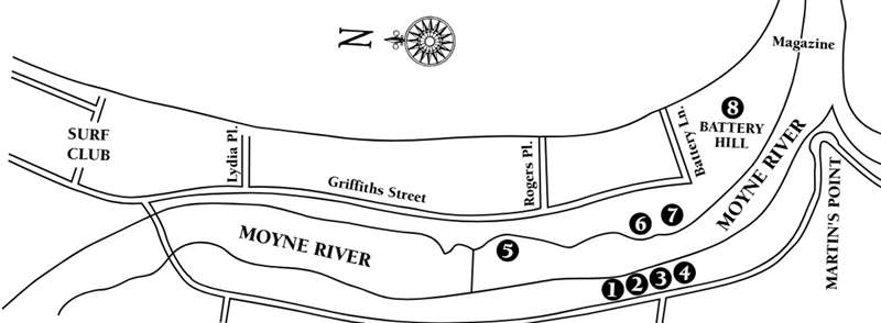
1. THE PORT
Ships originally anchored in the bay, transferring their passengers and cargo to the port area by boats and lighters (either sailing or towed barges), because the river’s entrance was too shallow. The west bank of the Moyne included a number of warehouses and jetties, as well as the public wharf and government facilities at King George Square. The Customs House (opposite the Casino Memorial) in Gipps Street, the adjacent Court House (History Centre) and the Gaol (now demolished) were vital government functions centred around the square.
2. PORT SERVICES
The round-topped wooden shed was originally erected in 1863 as a goods shed and terminus for the tramway that crossed the river and ran along Battery Lane onto a jetty in the bay. The jetty was ineffective due to its siting and quickly fell into disrepair. The bridge was demolished in 1873 and the shed located closer to the river. The shed was repositioned a third time when the railway was extended to the Square and it was then used by the Fisherman’s Co-operative. It is the only such general purpose government port building surviving in Victoria. The railway line ran through the back of the Steam Packet Wharf buildings and then crossed Gipps Street at Cox Street. Government vessels (the Customs and the Harbour Master’s boats) and the buoy boat were moored near the crane at the south end of the (public) wharf.
3. RIVER WAREHOUSE AND MILLS
Before you proceed along the jetty (upstream), note the bluestone two storeyed building on the southern boundary of the Square which was the Moyne Steam Flour Mill, built in 1860. It was originally four storeys high, with extensive storage buildings alongside, but it had a short and unsuccessful life as a flour mill. As you join the elevated jetty, note the bluestone lower storey of the grey house adjacent to the square (on your left) which was part of the Steam Packet Wharf, the berth of the BKSN steamers, while the property next door was originally the teamster’s yard. The cut-off piles between the shore and the jetty are the stumps of the original jetty, badly damaged in the flood of 1946. There were further privately owned loading jetties upstream, such as Rutledge’s jetty and Challacombe & Bishop’s jetty.
4. THE CASINO MEMORIAL
The steamer Casino was purchased by the Belfast & Koroit Steam Navigation Company (BKSN) in 1882 for £14,250 to ensure that the trade in agricultural produce flowing via Port Fairy would not be captured by the steamer companies operating from Portland and Warrnambool. The BKSN was particularly successful in this, outlasting its rivals, until voluntarily liquidated before World War 2. The Casino traded between Melbourne, Apollo Bay, Warrnambool, Port Fairy and Portland and, after 50 years of service, sank at Apollo Bay on Sunday morning, July 10th 1932. In gale conditions the Casino attempted to berth at the Apollo Bay jetty; however, despite several attempts the steamer sustained extensive damage and foundered. Ten lives were lost. The vessel’s propeller was recovered as the centrepiece of the memorial. The lifeboat bell, which surmounts the cairn, was originally hung on Flagstaff Hill in 1873, to be rung to summon the volunteer crew when required.
5. THE SWINGING BASIN
(east side of the river)
Bringing large vessels into the river provides protection against shipwreck (which was a not uncommon outcome when they anchored in the bay) but a turning circle (swinging basin) was required to allow the vessels to proceed to sea again. This was cut into the eastern bank of the Moyne and was undertaken at the same time as the plans of Sir John Coode, the English harbour engineer, were adopted to improve the function of the western ports. A hundred years later, the swinging basin was converted into a yacht marina. Climb the steps, cross the bridge and turn right. As you cross the bridge you can see on your left Goble’s Mill (flour) which had a jetty for loading flour onto lighters.
6. THE PORT OF PORT FAIRY
The Port of Port Fairy (a local committee of management for port facilities) now controls the original government Ports and Harbours Dept. assets which include two slipways, the lighthouse and navigation facilities. The government funded the blasting and dredging of the Moyne and the construction of the extensive training walls, designed to project the river flow into the bay, and reduce the need for dredging. The large slipway within the Port compound is widely used by fishing boats around the western coast and was first cut about 1890.
7. THE HISTORIC LIFEBOAT STATION
The wooden round-topped lifeboat house was originally built on the jetty projecting from East Beach near Battery Lane in 1862, but was dismantled and re-erected in the current location in 1873 and was fitted with a slipway to launch the lifeboat. The lifeboat was built in Williamstown, Victoria, and was delivered here in September 1857, making it the oldest surviving self-righting lifeboat in the world. It was restored in 1997 and is regularly launched by a community crew for exercise and to foster the town’s maritime connection. The bluestone rocket house contains a collection of 19th century maritime rescue equipment. The collection of buildings, artefacts and lifeboat is exceptional, preserved as they were in 1888. The Historic Lifeboat Station is open for inspection during holiday periods and by appointment at the Visitor Information Centre.
Location
Gipps Street, Port Fairy 3284 View Map


