Port Fairy Heritage Trail


Development of the Town
In the 1840’s, the town, then known as Belfast, developed rapidly, as Atkinson offered settlers long-term leases which conserved savings for house construction. Settlers were able to build homes on the land leased secure in the knowledge that the leasehold was for up to 31 years. These terms were sufficiently attractive that the population of Belfast grew to over 2000 people. Atkinson donated land for community purposes such as schools, churches, a lecture hall and a library. The leases were due to mature in 1885, which prompted investors to offer the Atkinson family a lump sum to purchase the land, which was accepted. The investment syndicate held a massive sale of lots in 1885, to profitably recoup their investment, and thus Atkinson’s original purchase was owned freehold by a wider population. At this time a significant number of cottages, schools, churches, banks, pubs and shops were built, including Government buildings such as the Lighthouse, Post Office and the Courthouse.
William Rutledge, a colleague of James Atkinson, was largely responsible for the economic growth of the town. His company ‘Rutledge & Co.’ was multi-faceted. Among other business, they were shipping agents, insurance brokers, wine/spirit merchants and warehouse operators. By 1862 James Atkinson had returned to Ireland, and ‘Rutledge & Co.’ had collapsed and was forced into insolvency, which was a serious blow to the fortunes of the town of Belfast.
A railway link to Melbourne was established in 1890 and the local economy, based on fishing and dairying, no longer solely depended on shipping services. The opening of the Glaxo milk processing business in 1920 offered an improved opportunity, but declining incomes, low property demand and isolation led to progressive economic decline. Efforts to establish a cement industry in the 1950s failed, and the town was economically depressed after World War Two. In the ensuing years, settlers favoured other towns such as Warrnambool and the early promise that Port Fairy had shown was not realised. Port Fairy’s growth continued to fluctuate with the rise and fall of the railway, fishing, cheese and butter factories and various other industries. Today, we have this economic downturn to thank for the many historic houses and buildings that remain from that era. However, the 1970s saw the beginning of recovery, with the Glaxo business thriving, BAMStone commencing and outside interest in purchasing properties. The survival of many buildings built prior to World War One has continued to attract visitor interest to the town, with a resurgence in property demand. In 2012, the town was internationally acclaimed as “the world’s most liveable town with a population of less than 20,000” in 2012 - what a turn-around!
What’s in a Name?
Port Fairy was named after the cutter, “Fairy”, captained by Henry Wishart, which entered the bay during a sailing expedition in the summer of 1828. Between 1835 and 1847 whalers and European settlers arrived to establish a colony. During this time, in 1843, Irishman James Atkinson purchased a “Special Survey” of approximately 20 square kilometres and envisaged a town which he called Belfast. Belfast was renamed, Port Fairy, on 27 May 1887 following a plebiscite where the majority of people chose “Port Fairy” as the name for the settlement.
A Brief History of European Settlement
Port Fairy has a wealth of 19th-century buildings listed by the National Trust of Victoria. There are over 60 classified buildings in the town and these range from small cottages to substantial homes and public buildings. This walking tour will reveal a variety of construction materials, designs and community functions, developed over the centuries. The historic buildings listed provide a selection of those with heritage value and character. Further information on the built heritage of Port Fairy is available from the Visitor Centre or from the Museum and Archives centre. The Museum is also home to the Port Fairy Historical Society. The Society works with the Moyne Shire and the Port Fairy branch of the National Trust and Heritage Victoria to preserve the heritage of Port Fairy.
Port Fairy Heritage Trail Map
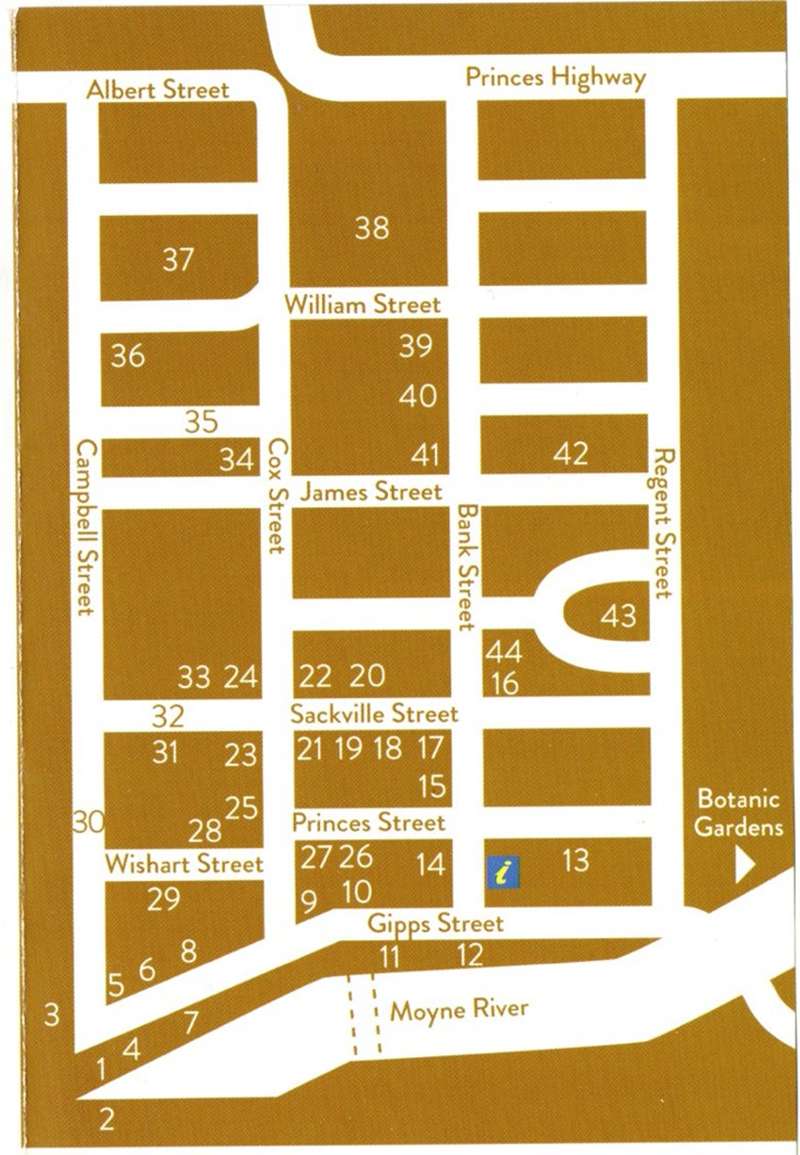
Port Fairy Heritage Trail Locations
1. Customs Gauging House, 1863.
For assessment of duty on tobacco & spirits.
2. Lifeboat House, 1862.
For a shore-based lifeboat; the 1857 self-righting, self-draining, restored vessel.
3. Merrijig Inn, 1846.
Courts sat at the Royal Merrijig Inn until 1860, also housed the officers of the Belfast District Road Board (from 1853) and the municipality of Belfast (from 1856-58).
4. King George Square, 1852.
Public land established for berths for government vessels.
5. Customs House, 1861.
An office and officer’s residence, when Victoria had its own customs duties.
6. Courthouse, 1859.
With additions, it hosted Supreme Court sittings, later transferred to Warrnambool. Now the Port Fairy Museum and Archives Centre.
7. Steam Packet Wharf, 1874.
The original Port of Port Fairy, extensive wharf warehouses constructed by Belfast & Koroit Steam Navigation Company.
8. Capt. Mills Cottage, 1843.
The back section is believed to be the oldest house standing in Victoria.
9. Cottage, 1839.
Possibly for John Griffiths, an entrepreneur and merchant from Launceston in northern Tasmania. The first substantial house (of four rooms) on the mainland, later substantially modified.
10. Moyne House, 1844.
Built and owned by Michael Connolly, named by some as “co-founder” of the town he was Griffith’s partner in the whaling station from 1835.
11. SG Henty’s Cottages, 1851.
Originally containing six imported timber cottages, each pair share a chimney.
12. Joseph Goble’s Steam Flour Mill, 1866.
A steam flour mill damaged by fire in 1891, later restored as a butter factory 1914-1939.
13. Railway Goods Shed, 1890.
To house merchandise to and from Melbourne. The Railway Goods Shed survived the rail line closer in 1977.
14. Warehouse, 1852.
It later served as an auction house, the Glaxo social club and now the scout hall.
15. Formally the Royal Oak Hotel, 1856.
Originally named The Commercial Travellers Association (CTA) it was the preferred accommodation for sales representatives travelling for work.
16. Star of the West Hotel, 1856.
Once a staging post for Cobb & Co coaches.
17. Lecture Hall, 1882.
The venue for stage performances, lectures, dances, dinners and later, films.
18. Former Mechanics Institute Library, 1865.
Replacing an earlier reading room, it is now the library.
19. Cheapside Warehouse, 1864.
Hutton Borthers Drapers. An example of the importance of shop frontages.
20. Artisan Shops, 1868.
Originally occupied by a tailor and saddler, now a bookshop and homewares.
21. Former Post Office, 1881.
A two-storey building in Classical Revival style, in which an arcaded front section with pediment and clock forms a balcony to residential rooms of the second story.
22. Former Bank of Australasia, 1857.
This building is one of the finest early banks in Victoria.
23. Colonial Bank of Australasia, 1911.
Began trading as the Colonial Bank of Australasia in 1911-12, later changed its name to the National Australia Bank in 1923-1924.
24. Former Stag Inn, 1847.
A remarkable building for its time.
25. Jago’s Garage, 1882.
A blacksmiths shop, then undertakers and plumber/garage since 1900.
26. Bank of Victoria, 1870.
The building was later a thread factory and now the Moyne Shire Office.
27. Emoh, 1844.
Once home to William and Eliza Rutlidge.
28. Seafield, 1852.
A domestic residence, later the Shire of Belfast Office, doctor’s rooms and a dwelling.
29. Wishart St,
Most houses were built between 1888 and 1909, providing built heritage continuity.
30. Campbell St,
The cottages from 24 to 30 were built between 1855 and 1856, 3 by immigrant masons.
31. Mott’s Cottage, 1842.
Built for a blacksmith, then became a rooming house, purchased by the National Trust in 1971.
32. Norfolk Island Pines,
Planted from 1869, they are a signature of Port Fairy, and provide a “fence” around town.
33. Cottages, 1853 (North).
Built as a bank and in 1874 (South) as the Shire of Belfast Office.
34. Apothecaries Hall, 1862.
Built for undertakers, later used for doctor’s rooms, restored as a residence.
35. Union St,
The narrow street was confirmed in 1862 and largely built after the syndicate sale of 1885.
36. Cottage, 1856.
Built by a stonemason, distinguished by the semi-circular fan light and balanced chimney.
37. Cottage, 1847.
A four room timber cottage, carefully restored “as found”, with a prominent front garden.
38. Presbyterian Church, 1854.
In rendered basalt, viewed between the modern church and the hall.
39. Cottage & Shop, 1888.
Moved from Rosebrook, used as a bakery, tinsmith’s and a green grocery.
40. Dublin House, 1870.
A drapery store, then a general business, bakery and butcher’s.
41. Caledonian Hotel, 1844.
With extensions, many of the dormers face into the unfinished attic area.
42. Wesleyan Church, 1856.
(Now Uniting) Is the second Wesleyan church, with the common school (1870) behind.
43. St Johns Church, 1856.
Also the second church, the tower (1967) to substitute for the intended spire.
44. Post Office/Borough Chambers,
Built 1865 as a post office, occupied by the borough of Belfast/Port Fairy for 109 years.
Location
Gipps Street, Port Fairy 3284 View Map
Web Links
→ portfairyhistoricalsocietyinc.org.au/heritage


