Port Fairy - Griffiths Island


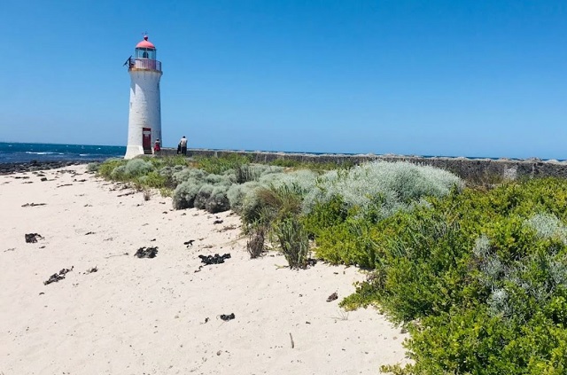
The highlights of Griffiths Island are its colony of shearwater seabirds, winding pathways and the spectacular lighthouse at the eastern tip.
A short walk along the causeway from Martin's Point gets you onto the island. Dogs are not allowed on the island and visitors are urged to stick to the walking tracks, which wind through the low lying scrub. Nesting birds, including the shearwater's that migrate from the northern hemisphere each year, create burrows for their young hidden in the sand and it's important these nests aren't disturbed by wandering sightseers.
The Island was name Griffiths after John Griffiths, who established Port Fairy's whaling industry on the island in the 1830's but no trace of this activity can be found today.
At dusk birdwatchers are in for a treat as the colony of shearwaters, or muttonbirds, return in swarms to their nests after a day fishing out to see. These little birds arrive here late September from the Aleutian Islands near Alaska. Following the laying and incubating of their eggs in January, the birds leave again for the northern hemisphere in April.
Griffiths Island Lighthouse
The Port Fairy Lighthouse was built of local bluestone around 1859 and is still in use. It guides ships into the security of Port Fairy located on the Moyne River. These days it's a solar powered light with a wind assisted generator. The lighthouse keepers' cottages were demolished in the 1950s; however, their gardens live on with many hardy plants flowering in the appropriate season. It is not possible to go inside the lighthouse.
The lighthouse grounds are open all year round but the tower is not open to the public. Tours are available on special occasions, but infrequently.
Warning: Snakes are most active during the shearwater nesting season in January.
Information Signage at the Rotunda
The Griffiths Island Area
Griffiths Island is a heritage place of historical and archaeological significance to Victoria. It is an interesting example of attempts to manipulate the environment to an imagined better outcome, despite the power of natural forces. The Island’s location allows the Moyne to flow directly into the sea.
SAFETY
High tides and strong south-westerly winds cause large waves to break over the causeway connecting the car park to the Island, and inundate the walkways. In such conditions you are advised not to cross over to the Island. If you find such conditions when you return from a walk, carefully observe the incoming waves (from the South West Passage entrance) and cross the causeway promptly, watching for the next wave. A wave is likely to knock you (particularly children) off your feet, with significant physical risk. Large kelp masses on the causeway are very slippery, and should be avoided.
The Griffiths Island Walk Circuit
The circuit is 3 kms. and will take about an hour. Visitors should stay on the path and not intrude into vegetated areas, particularly the sand dune leading to the trig station. As the prevailing wind is south-westerly, you may find walking anti-clockwise to be more comfortable. Following this advice will also offer the shortest return journey should high tide/strong winds prevent you walking over the beach on the other side of the Island. If confronted with such conditions, please retreat, rather than continuing. DO NOT try to make a path through the dunes, as there are thousands of shallow bird burrows.
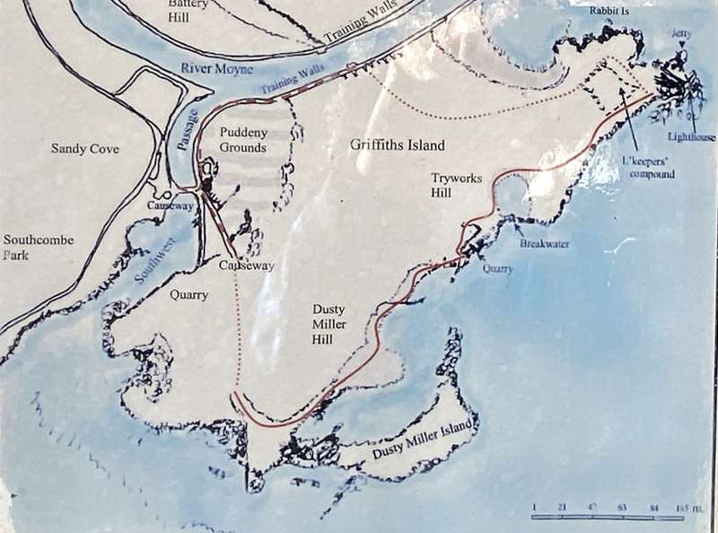
The map outlines the pedestrian track circuit, which includes a concrete topped causeway (broken red line), an unformed vehicle access track foot track, across beaches and boulders, sometimes over kelp (and not suitable for wheeled equipment – motorised or other), (solid red line) to the lighthouse, and then a rough vehicle access track (not advised for manually propelled wheelchairs) red dotted segment.
The vegetation on Griffiths Island
Early illustrations and maps of Griffiths Island indicate that there were no trees then evident, and an attempt to establish sheoaks on the Island in 1908 was unsuccessful. The Norfolk Island pines around the lighthouse compound and at Haldane’s Landing were planted by Harbour Master Hugh Haldane, together with some shiny-leaf trees (to provide wind protection) in the 1930s.
The Shiny-leaf trees, which had become dominant, were progressively removed from 2001, and The Friends of Griffiths Island Inc. attempted to establish indigenous trees ([obscured], Casuarinas, Banksias and myoporum) in 2013 in the expectation of revegetating the landscape. Wind protection for the new plantings was provided, ultimately to approximately 2 metres in height. The prevalent salt laden winds however, killed leaf growth appearing above the wind breaks. After seven years, it was decided to remove the screening, and the trees died from inability to cope with the conditions, or were ring-barked by wallabies.
The Friends of Griffiths Island Inc. have largely removed targeted “woody weeds” such as Italian Buckthorn, box thorn and dominant clumps of shiny leaf, the latter offering some feed for wallabies when rainfall is limited.
The Story of the "Spirits of Port Fairy": Short-tailed Shearwater Sculpture
The Friends of Griffiths Island Inc., embarked upon the re-vitalisation of this “rotunda”, to display historical and environmental information about Griffiths Island. It was intended that there should be an artistic “statement” for visitors to the Island, to emphasise its significance.
Don and Sherril Stewart considered the artistic representation of the daily return of the short-tailed Shearwaters to the nests at the fall of darkness, which limited visitors observing this spectacular event. The birds are migratory, and absent from mid April to late September, and the daily “return” starts in November. Don made a model of papier mâché, with a wingspan of 1700 mm (above right), and then made a two piece mould.
Each half of the mould was re-inforced with fibreglass and filled with crushed quartz, granite and marble, mixed with a Polyplex fillable casting resin. An [obscured] galvanised pipe was fitted to one half, with a steel mesh passing through the pipe and into each wing. The remaining half was joined to form the model, and the process repeated to make ten birds.
The birds are mounted on epoxy coated poles and each comprises three twisted pipes which have been welded and bolted to the foundation.
The South West Passage
The South West Passage was a seaway connecting with the Moyne River (thereby forming the island) and with an adjacent wetland subject to tidal flooding, of which Sandy Cove Reserve (west of the car park) is a remnant. The Southern Ocean kept the Passage navigable, and it was sometimes used as a short cut by fishermen, but only feasible in rare conditions.
In 1878 the visiting English marine engineer, John Coode, proposed that the training walls extend into the Passage to use the wave momentum to scour the river and carry river silt into Port Fairy Bay. The serpentine walls remain, although Coode never contemplated the causeway barrier now in place.
The causeway was made in 1913, after the steam ship Eumeralla became wedged between the training walls when it lost its heading when passing the Passage. Wave surge also hindered sail powered fishing boats during the tidal change. The southern wall and causeway later had a tramway to carry basalt blocks from the Island for the construction of the Warrnambool breakwater.
Narrow openings were made in the mid 1930s and again between 1946 and 1956 in response to community demands to improve water quality. The causeway was sealed again, to allow vehicular access to the lighthouse and to reduce the dredging cost.
Residents connected the closures of the Passage with increased erosion on East Beach, and noticed abatement when the causeway was partially breached. Substantial erosion on East Beach continues, the Passage accumulates sand and waves now break over the causeway in extreme conditions. What is the solution?
Fishing at Port Fairy
Commercial fishing developed at Port Fairy to provide a supplementary income to wharf labourers, who targeted southern rock lobster. Fishing with hand lines and small nets became an “occupation” about the 1880s. It became a family pursuit when larger (7-9 metres length) ’couta boats were adopted. Catches of barracouta, Australian salmon and trumpeter increased when the railway reached Port Fairy in 1891, allowing the catch to be sold in Melbourne.
The fishermen of Queenscliff, Port Phillip and Western Port also supplied Melbourne, so the price received for the consigned barracouta was often unremunerative, due to over[supply]. Fishermen accepted considerable risk, long hours, unpleasant conditions and ha[rd lab]our for their income, with few alternative employment opportunities.
In the 19[obscured]s and 1930s there were 35 to 40 registered fishing boats at Port Fairy. Local fishermen accounted for about 40% of the gummy shark (which became popular for fish and chips before the World War 1) and barracouta caught in Victoria.
Fishing boats became specialised - for crayfish, shark, and more recently, abalone. Limited fish stocks, catch quotas, permits and the capital cost of larger craft has reduced the fishing fleet.
Visitors are reminded they must possess a current fishing licence to fish in marine, estuarine and fresh waters, if aged between 18 and 70 years unless exempt.
Whaling History on Griffiths Island
A shore based whaling camp was made on Rabbit Island, near the lighthouse, by 1833, and the whale oil was taken to Launceston. By 1836, the annual camp, with permanent buildings, was set up on “Port Fairy Island”, with visits by supply and uplift ships from April until October, when the crews and coopers would return to Launceston.
In the following three years, trading vessels, Elizabeth, William and others delivered men, boats, gear and materials for each season. In the early 1840s, the lack of returning whales meant the harvest was at an end. The camp remnant was buried under the wind-blown sand and the buildings removed subsequently.
There were about 4 to 5 whaleboats at the camp, each crewed by six men (5 pulling oars and a sweep oar) and they carried a sail. The whaleboats were relatively light and easily built, and carried about 350 metres of line attached to the harpoon. The whaleboats were 9 metres in length, 2 metres wide and required a skilled and strong crew to handle the boat and particularly, to fasten to the southern right whale.
A replica of a whaleboat is usually moored in the Moyne River, near the historic lifeboat station, and taken to sea regularly, for enjoyment and to demonstrate the maritime history of Port Fairy. Whaleboats were used for movement of personnel between ship and shore.
The Geology of Griffiths Island
Griffiths Island protects the Moyne River mouth, which drains 300 square kilometres of hinterland. Rivers running into the Southern Ocean (such as the Murray, Glenelg and Hopkins) are usually blocked by sand bars created by the overpowering wave force. Griffith Island diverts the Moyne River eastwards into protected Port Fairy Bay.
A basalt lava flow from Mount Rouse (Penshurst) some 40,000 years ago provided this protection. The black boulders along the South West Passage and the beach on the far side of the Island are remnants of this flow. It is possibly a collapsed lava tunnel (an intact example can be seen at Mt Eccles, near Macarthur). On the south side of the Island, near the end of the foot track, limestone, approximately 100,000 years old, can be seen. The Island landform is covered with wind blown sand dunes, less than 10,000 years old. Their shape on the windward side, unless consolidated by marram grass or vegetation, is changed by the wind, rain and sea.
Basalt outcrops appear at Rabbit Island, Goat Island (in the Puddeny Grounds), in stone quarries near the lighthouse and the southern side of the Island, and the extensive rock platforms which stretch south and east of the lighthouse, forming the shallow reef observable in all conditions.
Griffiths Island Lighthouse
The lighthouse was built in 1859 in volcanic basalt rock quarried close by - in 9 months - which included opening the quarry (about 450 metres south west), dressing the stone and building the keepers’ cottages. It was one of five (Port Albert, Cape Schanck, Warrnambool and Portland) completed that year.
The light was managed by a keeper and an assistant, whose jobs included cleaning and fuelling the light, winding the clockwork mechanism (for rotating the light) and keeping watch throughout the 24 hour day. Communication with the town was by boat.
The signalling flagstaff was moved from Battery Hill to a rise behind the lighthouse following the construction of the battery. It was necessary to signal the river depth for vessels intending to enter.
In 1952, Hugh Haldane, the last keeper, left the station. The cottage was demolished and the light was successively fuelled by acetylene gas, wind and solar power.
The tower incorporates the staircase as cantilevered steps projecting from the wall. The light is 13 metres above sea level and visible 9 nautical miles (17 kms) at sea, and has a particular flashing sequence to distinguish it as located at Griffith Island. The lighthouse and the station precinct are protected under the Victorian Heritage Act, 1995.
The Moyne River Training Walls
The attempt to provide a pier into the bay failed, as vessels were unable to be protected from wave movement. The subsequent removal of the sand bar at the river’s entrance and dredging allowed vessels to reach the warehouses near King George Square. Training walls were built along the river edge, projecting into the bay, to provide a safe entry. The first vessels entered in 1873.
The river and the South West Passage were progressively walled, to confine the river, limit flooding and to assist the tide and the river current to carry silt into the bay over the next fifty years.
Regular dredging continued. The spoil was deposited in the channel between Griffiths and Rabbit Islands, in the Puddeny Grounds and as fill to create Martin’s Point.
The walls were built of basalt (bluestone - sometimes dressed, usually roughly shaped) quarried from Goat and Griffiths Islands. The training walls were added to the Victorian Heritage Register in 2009 for their historic and scientific (technical) significance.
Coastal Margin Change
The geographic form of Griffiths Island has been significantly altered since it was mapped by John Barrow in 1843. The outline of his assessment of the margins of the above water surface are shown below in red over aerial images of the Island taken in 2013. The scale has been adjusted to “match”, but the Barrow plan shows some obvious inconsistencies on basalt shorelines; however the extent of subsequent sand/silt accumulation is evident.
Short-tailed Shearwaters
(Muttonbirds) Ardenna tenuirostris
Griffiths Island is the “summer” (late September to early May) home of 15,000 Short-tailed Shearwaters. The birds have inhabited the Island for centuries, and were first formally recorded by a lighthouse keeper in 1864. These birds have an annual circuit flight from Griffiths Island (also from Philip Island, Bass Strait and the Tasmanian mainland) along the western side of the Pacific Ocean then to Japan, the Bering Sea and Alaska. They commence their return circuit in mid August, through the centre of the Pacific Ocean. The birds are efficient fliers and fishers (of krill, squid and fish) and can dive to 10 metres.
They are usually socially monogamous, and the female lays one egg in a burrow that the pair return to each season. Both birds take turns to incubate the egg, which hatches in 53 days (the third week in January).
After several weeks rearing, the parents leave a fortnight or so before the chick departs on its first flight to link up with them at sea. Adult birds average 500 grams, and the chick reaches up to 900 grams before its parents cease feeding it.
The birds return to Griffiths Island at the end of the third week in September, and many die from exhaustion, starvation and feral animals (cats and foxes), as they are clumsy on the ground. Humans also cause fatalities by stepping on, and falling into, burrows.
The birds can be viewed in flight on the Island between November and March after the setting of the sun, but before full darkness. Please stay on the pathway to protect our shearwater population.
Residents and Visitors
SOUTHERN RIGHT WHALES: Between May and late August, these whales might be seen in Port Fairy Bay and off Griffiths Island. They are generally females, present to give birth in shallow, sand floored bays, to maximise the easier detection of sharks. This behaviour encouraged the whalers to camp on Griffiths Island to hunt the whales for oil and baleen, until they had almost exterminated them. The whales have been absent for over 150 years until they returned recently. The six vertebra in the ceiling space were found on Griffiths Island in 2000.
AUSTRALIAN FUR SEALS: A large colony of mature seals live on Lady Julia Percy Island (to the west, visible from the car park overlooking the South West Passage entrance), while at Cape Bridgewater, there is a seal nursery. Young seals may be seen around Griffiths Island and in the Moyne River, and they sometimes haul out onto the beach or training walls to rest and sleep. They are generally about 1 to 1½ metres in length, and weigh less than 50 kg. Please remain 30 metres from any seal.
BOTTLENOSE DOLPHIN: Pods of dolphin may occasionally be seen at sea throughout the year. Adult males and females are about 3 metres in length, and 650 kg in weight, larger and significantly heavier than Fur Seals. They are usually in groups and are mobile in the water, rather than “frolicking”, as isolated seals tend to do. They are distinctive for the small curved-back dark dorsal fin evident above the waves.
FAIRY (also LITTLE) PENGUIN: There are small colonies of Fairy Penguins in the area, usually apparent by the occasional dead carcass on the beach. There is a colony at Middle Island (Warrnambool) which has been reduced by the impact of feral animals and foxes. The birds weigh about 1 kg, lay eggs and generally spend the day at sea (like the shearwaters) unless incubating their eggs.
Flora, Fauna & Birdlife
Much has changed on Griffiths Island since the 1830s. There are invaders now on all fronts but local species have persisted and survived.
You could see up to twenty wallabies browsing. They accept your presence and will pose for photographs. You may see the echidna, nosing about looking for an ant meal. There are reptiles: blue-tongued and stumpy tailed lizards, species of skinks and sometimes, tiger or copperhead snakes, which seek to avoid disturbance by visitors. Curiously, the blue-tongues have developed a dorsal pale sandy colour to blend in with the s[obscured] defence against predatory birds.
At late dusk, from late September to early April, the short-tailed Shearwaters return to their nesting burrows. There are resident and visiting shore-birds, feeding on the beaches and tidal flats. Hawks and falcons may be seen hovering as they search for mice, rats and small lizards. Along the river there are cormorants, white faced herons and the beautifully plumaged nankeen night heron.
Plants survive, despite the difficult conditions. Windswept, they grow close to the ground. On the southern side of the Island, the sea-berry saltbush and the creeping succulent, “Sailor’s Spinach”, is abundant. On the shore of the Puddeny Grounds, there is an extensive stand of Shrubby Glasswort, temperate landbuilders and a habitat for the orange-bellied parrot.
There is no fresh water on the Island except rainfall, which collects in the rock hollows, and the night dews, so important in supplying moisture to aid the survival of the plants, animals and birds of this unique Island.
Please avoid startling the animals or birds that you come across.
Environmental Recovery
The form and vegetation of Griffiths Island is significantly different from that when Europeans arrived, who attempted to modify it to suit their ambitions. Developments included breakwaters, training walls, tree planting, exotic plants and vehicle tracks.
Geographical: The insertion of walls to stop, or re-direct, the sea and river (supplemented by dredged spoil) led to a larger area for the original group of islands (Rabbit, Griffiths and Goat). The whaling beach is now some 60 metres from the water.
Whaling: Over 500 whales were taken by the whalers between 1833 and 1845. The hunt was suspended after the mothers and calves had been almost wiped out and whales did not return to Port Fairy. Southern Right Whales can sometimes be seen in the bay between May and August, and their re-appearance will be, hopefully, annual.
Fishing: The catch of barracouta and other fish is now past, with some species rarely found, and others (such as rock lobster) controlled by permit and season.
Grazing: Grazing rights to the Island were offered for lease in 1912, despite the presence of the shearwater burrows on Griffiths Island. The lighthouse keeper was allowed to keep a cow and remnant fences can still be seen.
Rabbits: The burrows were ripped by machinery in an attempt to remove rabbits in the 1950s and 1960s, which is likely to have been the time when cape weed became prevalent.
Quarries: Basalt outcrops provided material for public works and buildings. The sites are now overgrown and barely recognisable.
Vegetation: Indigenous and weed species have reclaimed the areas created from spoil deposition and “blow-outs”: Leucopogon (Coastal beard heath), Gahnia (Coast saw-sedge) and Tetragonia (New Zealand spinach), cape weed and grasses are common. Some pernicious weeds (Sicilian Sea Lavender, African Boxthorn, New Zealand Shiny leaf, Italian Buckthorn etc) remain, targeted for gradual removal by Friends of Griffiths Island volunteers.
Review:
A really interesting walk where you can adjust the length depending on the route you take. Irrespective of the season, it can be vey windy and cold, so dress appropriately. During the summer months be especially wary of snakes. There are no toilets but there are some about 200m away at the Lions Park playground at Martins Point.
Location
Griffiths Island, Port Fairy 3284 View Map
Web Links
→ www.moyne.vic.gov.au/Our-Community/Environment/Griffiths-Island-Port-Fairy
→ The Lighthouse (Moyne Shire)


