Pioneer Park Playground, Mirboo North-Trafalgar Road, Thorpdale


The playground has a number of areas. There is a fenced area with a standalone slide, sandpit with digger covered by shade sail, see-saw, monkey bars, swings, horse springer, kangaroo springer and stand-on spinner.
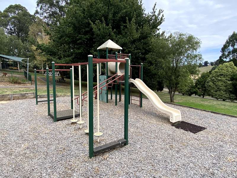
Another area has a structure with wave slide, scrambling wall, climbing wall, fireman's pole, ladder and tunnel.
Also a very long metal flying fox and basketball half court. Huge shelter with four tables and BBQs, shelter with seats and information panels, water tap, toilets and three unshaded tables.
There are a lot of information panels in the shelters at Pioneer Park. They include:
The Thorpdale Railway
Opened in 1888, the Thorpdale railway line was originally planned to link Moe on the main Melbourne-Sale railway line to the original Thorpdale, which is now known as Thorpdale South.
However. construction of the line was difficult and costly as it passed along steep terrain and needed many trestle bridges over the Narracan Creek. The line terminated about 3km short of the original Thorpdale (renamed Thorpdale South in 1888) and it was around this rail head that modern day Thorpdale (briefly called Warrington) grew and developed.
The railway line ran from Moe along the Narracan Valley through the stations of David, Coalville (where the Moe Coal Company's, mine was located) and Narracan to Thorpdale. The opening of the rail line stimulated development in Thorpdale and replaced haulage by bullock wagons to Trafalgar. The station yards soon became the busy centre for loads of timber from the district saw mills while the cool stores, built in 1890, were packed with the district's farm and fruit produce. There was a daily delivery of mail and newspapers and the Coalville doctor would visit weekly. The station was also the post office and telegraph station for many years.
The train took 50 minutes to travel from Moe to Thorpdale or return, but this time was shortened by 1900. The service was well used in the 1890s but stern dectineed from a daily service to three trains weekly by 1926. Improvements in road transport, the merging of smatter farms into larger holdings, increased farm mechanization, the consequent reduction in the rural population and the cost of maintaining the trestle bridges led to the line becoming unprofitable.
The last passenger train ran in 1944 and the last goods service ran in 1958. The line was dismantled In 1961-2. The old railway yard site has been occupied since 1966-7 by the Thorpdale Bowling Club. Remnants of the trestle bridges can be seen at the Narracan Falls picnic ground and walking track.
Travellers Rest Hotel
In the early 1900s, there was no hotel in the township as the predominantly Wesleyan-Methodist settlers opposed the granting of a licence.
In 1903 Michael Hogan was unsuccessful in gaining a hotel licence and in 1905 he bought an existing general store which he operated with a colonial wine and billiard room licence and subsequently tea and dining rooms.
In 1908 Michael Holden, a former policeman and successful applicant for a hotel licence, bought out Hogan and established what was to become the Travellers Rest Hotel, The original building was an old weatherboard structure with a tin roof and a wide verandah along the front; one storey at the front, two storeys at the rear. It housed the general store and the colonial wine and billiard room.
Through the hard work and enterprise of Michael Holden and his wife Honoria, the hotel flourished. In 1924, their son Tom married Eileen Sheehy and together they continued living and working in the Travellers Rest.
In 1937, the general store' was transferred to a new building across the road and plans for a new hotel were drawn up. The old hotel was demolished, except for the old general store which became a temporary bar during the construction period. The first brick was laid in August 1937 and the new Travellers Rest Hotel was opened on 7 January 1938. 'The Argus', on 8 September 1937, in an article headed 'Modern Hotel for Thorpdate' stated 'A link with the South Gippsland of 30 years ago was lost last month when the old Travellers Rest Hotel of Thorpdale was demolished to make room for a modern brick building, designed to cater for local needs & the increasing amount of road traffic at this hitherto beauty spot'.
The owner and Licensee of the new Travellers Rest, Michael Holden, had held the licence since it was granted 30 years earlier. From the 1940s, Michael Holden's granddaughter Marie, who later married Frank Bantock, carried on running the hotel. Her son, John Bantock, is a fourth-generation family member to work in the hotel started by his great-grandfather in 1908, In 2009, John Bantock and his family celebrated their 100 years in business at the Travellers Rest Hotel.
Potato Growing in the Thorpdale area
The Thorpdale district supplies around 17% of Australia's eating potatoes and 25-30% of certified seed potatoes.
Most of the local farming families have been associated with potato growing at one time or another. The early settlers found that a potato crop was an important tool in clearing the ferny hills and establishing good pasture as well as bringing in a little cash. The potato industry has changed markedly over the years.
Until the mid-1950s most potatoes left the district by rail. Prior to the 1930s. potatoes arrived at the Thorpdale and Narracan railway stations by dray or wagon after a laborious journey through deep mud and over roughly metalled roads. Improved roads and motor transport enabled bigger loads and easier transport to railway stations. Nowadays, semi-trailers transport potatoes interstate within a couple of days after harvesting.
Irrigation coupled with American varieties of potatoes such as Sebago, introduced in the late 1940s and chosen for their high yield, regular shape and disease resistance, have increased yields significantly. However, many people believe that some of the older varieties were better eaters.
Potato farming has developed from manually intensive to highly mechanized processes. In on early 1900s most potatoes were planted by dropping behind a plough and were dug by hand. From the late 1940s, tractors became common and harvesting became more mechanized.
In 1939 the Victorian Department of Agriculture introduced a seed certification scheme for potatoes and, shortly afterwards, certified crops were grown by Thorpdale farmers H Powell & Sons and Auchterlonie Bros. Now, Thorpdale produces a significant amount of world-class certified seed.
In general, potatoes have been a profitable enterprise for local farming families who have built on and reaped the rewards of the hard work and sacrifices of earlier generations. In 2010, the highly productive farmland around Thorpdale is predominantly used for growing crops (such as potatoes and onions) and raising sheep and cattle.
Thorpdale past & present
Whilst many people may not know the exact location of Thorpdale, they immediately associate the name with potatoes. For well over a hundred years, Thorpdate has been producing high quality potatoes of many varieties and, since 1940, certified seed.
When you look around today at the Thorpdale countryside, you see a prosperous farming landscape with rolling hills of deep rich red basaltic soil, excellent for growing potatoes and onions, and for pasture for dairy and beef cattle as well as for sheep grazing. The relatively high rainfall experienced in the area also contributes to the productivity of the land.
However, when this part of Gippsland was settled in the mid 1870's, the first pioneer families (Auchterlonie, Savige, Heal, Powell, Gange, Cornthwaite, Gunn) encountered quite a different landscape. The hills were densely forested with giant 'mountain ash' trees (Eucalyptus regnans), other eucalypts, tree ferns, wattles, sassafras, clematis, ferns, wild flowers and wire grass.
The hills also abounded with native birds and animals - wallabies, pademelons, echidnas, marsupial mice, native cats, tiger cats, bandicoots, possums, koalas, wombats, dingoes, parrots, cockatoos, crows, bower birds, hawks, lyrebirds, magpies, kookaburras, blue wrens, thrushes and fantails.
Remnants of these forests can be seen at the Lyrebird Walk 10 minutes drive away along the Mirboo North Road, the R.N. Auchterlonie Tree Reserve on McDonalds Track near Narracan and at Mt Worth State Park 30 minutes drive along the Childers - Allambee Roads.
One of the giant trees that covered the hillsides holds the record for being the world's tallest tree. The site, marked with a plaque, where this giant eucalypt once stood is on McDonalds track in Thorpdale South. It was located on the property of W. Cornthwaite and measured in 1884 by his brother George Cornthwaite, a Government surveyor. It was recorded at 370 feet (113m) and when felled a year later measured 375 feet (114.4m).
The first influx of pioneers had to battle their way through the dense and almost impenetrable scrub along McDonalds Track and faced immense hardship in clearing and establishing their selections. Basic provisions and simple hand tools were all that could be carried in by pack horse or on a horse drawn dray. The men came first in order to clear an area on which a house could be built and vegetables and fruit trees planted. Their womenfolk followed and settlements slowly developed.
The original pioneers, whose descendants still live and farm in the Thorpdale area, were quickly followed by many more settlers especially after the development of the Gippsland railway. The discovery of coal in the Narracan Valley also fuelled further settlement and led to the establishment of several villages. The Thorpdale railway was opened in '1888 and provided a vital service for the Moe Coal Company and many timber mills in the area. It also enabled farmers to quickly send their vegetable crops, fruit and butter to market.
Unfortunately, owing to improved road transport, the service declined and stopped running in 1958. The end of the line for the Thorpdale Railway was located where the Bowling Club now stands and the route followed the Narracan Creek along the way to Narracan, Coalville and Moe crossing the creek at several points along its journey.
Remnants of the trestle bridges can be seen at the Narracan Falls picnic ground where there is a signposted 40 minutes 'Narracan Way' walk (follow the orange triangles) that roughly follows the route the rail line took to Narracan.
Photos:
Location
Mirboo North-Trafalgar Road, Thorpdale 3835 View Map


")