Omeo Valley - Hinnomunjie Bridge


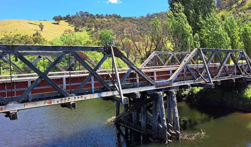
The historic Hinnomunjie Bridge crosses the Mitta Mitta River in the peaceful Omeo Valley. Also known historically as the Mitta Bridge, the timber-truss bridge opened in 1910 and was constructed using hand-hewn timber. Broad axe marks remain visible on parts of the structure.
The bridge is listed on the Victorian Heritage Register as H0917. East Gippsland Shire Council describes it as Victoria's second-oldest timber-truss bridge, while Heritage Victoria identifies it as the last timber-truss bridge remaining on the Victorian Heritage Register following the loss of other bridges during the Black Summer bushfires.
The bridge no longer carries vehicles, with traffic using the modern bridge immediately alongside it. East Gippsland Shire Council reported in 2023 that the historic bridge was closed to vehicles but open to pedestrians. Conservation and stabilisation work has subsequently been planned, so visitors should obey all current signs and barriers.
The surrounding river frontage is a scenic place for photography, trout fishing, freshwater swimming and watching the sunset. Hinnomunjie Bridge is also an important take-out point for experienced rafters and kayakers travelling down the upper Mitta Mitta River.
Hinnomunjie Bridge is an interesting short stop on a drive through the Omeo Valley. The weathered timbers, visible axe marks and multiple trusses provide a close look at an increasingly rare form of bridge construction. The modern bridge beside it provides an excellent contrast between early twentieth-century engineering and the present road crossing.
The river and surrounding hills create an attractive setting, particularly late in the day. Allow extra time if you plan to fish, picnic or explore the river frontage.
Features include:
- Heritage-listed timber-truss bridge
- Hand-hewn structural timbers with visible broad axe marks
- Views along the Mitta Mitta River
- Fishing
- Freshwater swimming
- Popular rafting and kayaking take-out point
- Informal riverside day-use area
- Photography and sunset views
Important:
The historic bridge is closed to vehicles. Pedestrian access may be restricted during conservation work, inspections or when the structure is considered unsafe. Do not cross barriers or enter a closed section of the bridge.
Camping arrangements at the surrounding river frontage were under review during 2026. This listing should be treated as a day-use listing. Do not camp unless current onsite signs clearly confirm that camping is permitted in the selected area.
The Mitta Mitta River can be cold, deep and fast-flowing. There are no lifesaving services. Check water conditions carefully, supervise children closely and avoid entering the river during high or fast flows. White-water rafting and kayaking upstream of the bridge are suitable only for appropriately experienced and equipped paddlers.
Location:
Hinnomunjie Bridge Recreation Area, beside the modern road bridge over the Mitta Mitta River, Omeo Valley Road, Omeo Valley.
Approximate coordinates: -36.9455, 147.6080.
Opening Hours:
The surrounding day-use area is generally accessible at all times, subject to bridge restoration work, temporary closures, river conditions and onsite restrictions.
Cost:
Free.
Access for Dogs:
A current official dog-access rule for the river frontage could not be confirmed. Keep dogs under effective control, use a leash and obey onsite signs.
Information Signage at the Bridge
Mitta (Hinnomunjie) Bridge
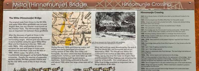
The original route from Omeo to the Mt Wills and upper Mitta Mitta goldfields was not past Anglers Rest, but via a shorter route known as the Knocker Track. The Hinnomunjie Crossing was an important link between these goldfields.
After the discovery of gold at Omeo in the early 1850s miners were prospecting the surrounding ranges. Alluvial gold was discovered in many localities along the upper Mitta Mitta River and its tributaries in the late 1850s and early 1860s. Only small parties of miners occupied the area until large tin lodes were discovered at Wombat Creek and Mt Wills in 1888. Within a year, the whole of the mountainside was pegged out by hastily floated companies. Despite the erection of expensive recovery plants, the field proved a failure and by the mid 1890s work on the tin had virtually ceased.
During the early 1890s gold-bearing quartz reef mines were being developed around new mining centres at Glen Wills, Glen Valley and Sunnyside. Far more substantial than the brief tin mining boom, numerous reefs were taken up, with companies erecting crushing and recovery machinery. Gold mining continued to flourish until about 1900, when two large mines were still at work.
Most reef workings were abandoned by the end of the First World War, and Sunnyside was all but deserted by 1920. The Maude and Yellow Girl continued to be worked at Glen Wills until the 1950s, but by this time the route via Anglers Rest and the present Omeo Highway was attracting the majority of the traffic. For a brief period, the Mitta truss bridge provided an important link to the goldfields of Mt Wills.
Hinnomunjie Crossing
1840: Hinno Munjie Station of 36,000 acres taken up by Edmund Crooke for the horse trade.
1849: A ford surveyed over the Mitta Mitta River for free public access
1870s: A boat was used to ferry mostly foot traffic. Horses and vehicles fording the stream when river was low.
1877: New punt authorised, previous one washed away in floods.
1890: Site selected for a bridge.
1891: First bridge over the Hinnomunjie Crossing constructed. 120 feet (61m) long with a 18ft 6in (5.6m) clear roadway, carried on four Blue Gum piers.
1898: Flooding causing collected debris to endanger the whole structure.
1908: Bridge closed to traffic due to damage caused by floods over the years. The ferry service reinstated.
1908 - 1910: New road built on the present highway alignment from Omeo to Glen Wills.
1909: New bridge designed by Omeo Shire Engineer S.J. Gay, known as the Mitta Bridge.
1909: April: Peter Ringberg awarded the contract.
1910: April: New bridge opened.
1949: Repairs to abutments after flood damage. The new bridge had withstood many big floods.
1960s - 90s: Various repairs and maintenance to the bridge.
1991: Funding awarded to Omeo Shire for the replacement of the bridge. Some councillors supported the retention of the bridge. Heritage value of the bridge officially recognised and registered under the Historic Buildings Act 1984.
1993: Second biggest flood in 62 years washed away part of the south abutment.
2003: Bridge damaged by bushfire. 900mm steel beams installed to preserve and strengthen the structure.
2004: New concrete and steel beam bridge designed and constructed downstream of timber truss bridge.
A Rare Survivor
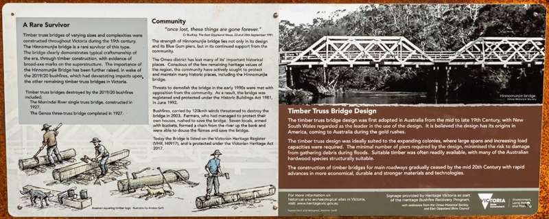
Timber truss bridges of varying sizes and complexities were constructed throughout Victoria during the 19th century. The Hinnomunjie bridge is a rare survivor of this type. The bridge clearly demonstrates typical craftsmanship of the era, through timber construction, with evidence of broad-axe marks on the superstructure. The importance of the Hinnomunjie Bridge has been further raised, in wake of the 2019/20 bushfires, which had devastating impacts upon the other remaining timber truss bridges in Victoria.
Timber truss bridges destroyed by the 2019/20 bushfires included;
The Murrindal River single truss bridge, constructed in 1927,
The Genoa three-truss bridge completed in 1927.
Community
“once lost, these things are gone forever.” - Cr Buckley, The East Gippsland News, 23 and 25th September 1991.
The strength of Hinnomunjie bridge lies not only in its design and its Blue Gum piers, but in its continued support from the community.
The Omeo district has lost many of its important historical places. Conscious of the few remaining heritage places of the region, the community have actively sought to preserve and maintain many historic places, including the Hinnomunjie bridge.
Threats to demolish the bridge in the early 1990s were met with opposition from the community. As a result, the bridge was registered and protected under the Historic Buildings Act 1981, in June 1992.
Bushfires, carried by 120kmh winds threatened to destroy the bridge in 2003. Farmers, who had managed to protect their own houses, rushed to save the bridge. Seven locals, armed with buckets, formed a chain from the river up the bank and were able to douse the flames and save the bridge.
Today the Bridge is listed on the Victorian Heritage Register (VHR, H0917), and is protected under the Victorian Heritage Act 2017.
Timber Truss Bridge Design
The timber truss bridge design was first adopted in Australia from the mid to late 19th Century, with New South Wales regarded as the leader in the use of the design. It is believed the design has its origins in America, coming to Australia during the gold rushes.
The timber truss design was ideally suited to the expanding colonies, where large spans and increasing load capacities were required. The minimal number of piers required by the design, minimised the risk to damage from gathering debris during floods. Suitable timber was often readily available, with many of the Australian hardwood species structurally suitable.
The construction of timber bridges for main roadways gradually ceased by the mid 20th Century with rapid advances in more economical, durable and stronger materials and technologies.
Location
Omeo Valley Road, Omeo Valley 3898 View Map
Web Links
→ www.visiteastgippsland.com.au/our-region/alpine-high-country/omeo-benambra
→ www.parks.vic.gov.au/places-to-see/parks/alpine-national-park/attractions/omeo-mitta-mitta


