Myrtleford - Reform Hill Walk


Reform Hill is located at the south eastern end of Myrtleford, opposite the Old Butter Factory.
Reform Hill is named from a rich gold bearing quartz reef discovered in 1854. Trial crushings yielded a high proportion of gold, ten ounces to the ton. The gold bearing quartz was 7 metres wide in places and ran through the core of the hill, estimated to have yielded approximately 21,500 ounces of gold. For over 30 years the Reform Mine was a principal employer within Myrtleford. The mine closed in 1888 due mainly to a large amount of water entering the shafts. Today it is a peaceful recreational location providing great walking tracks past historical mining features and picturesque native forests, the typical trees including Red Box, Long-leaf Box, Red Stringybark and Broadleaf Peppermint.
There is a bushland walk loop which is about 3.4km past old mining sites, historic markers and mosaics to reach a pleasant lookout. It is a formed, signposted track with some steep hills and steps. Start at Jones Park on Myrtle Street. A number of short trails loop around the State Forest and can be walked in various configurations. Follow the signage to the lookout along the trail on the northern side of the hill and descend on the southern side.
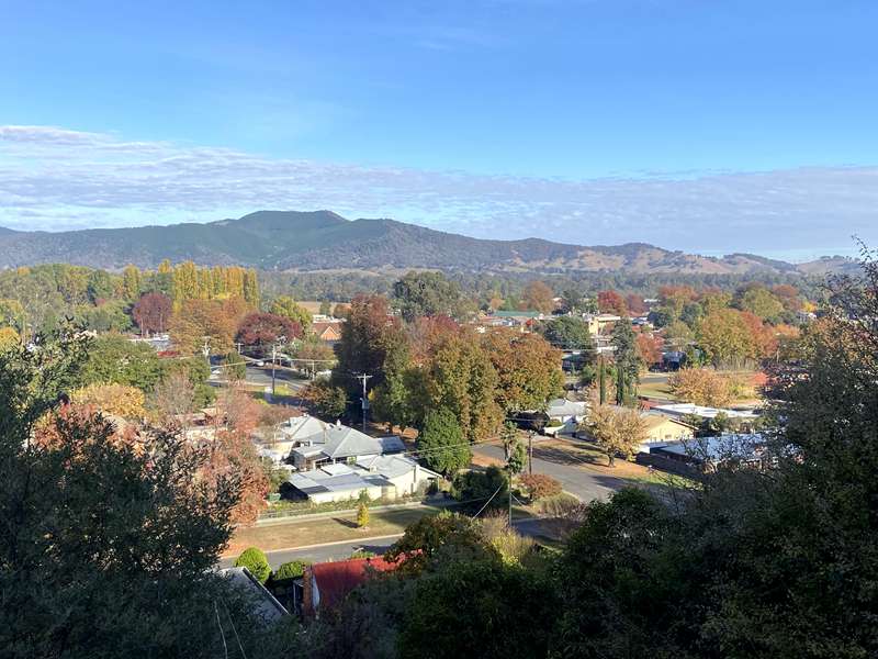
If walking is not an option you may drive your car to within 50 metres of the lookout, providing views down the Ovens Valley, Mount Buffalo and the Victorian Alps. Well worth visiting at any time of year.
Map of Routes
Reform Hill has four colour coded loops/walks. You can create your own walk which links up these walks.
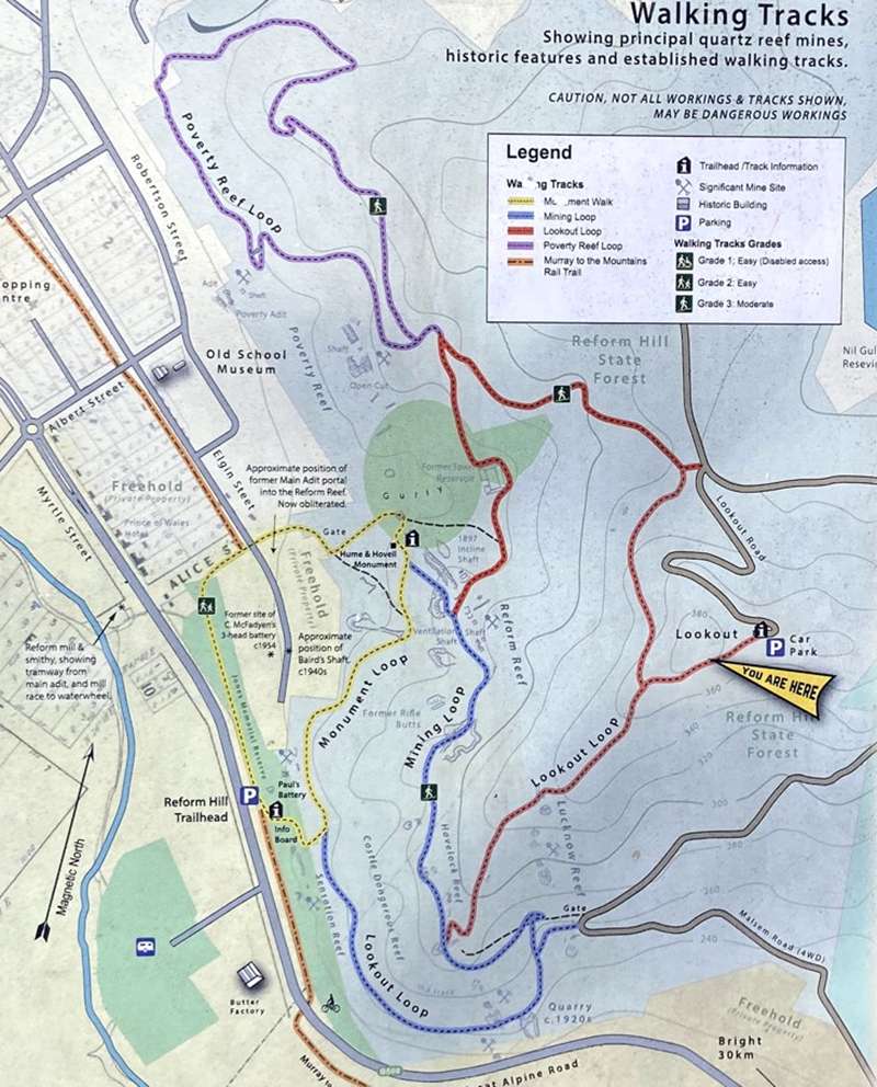
Lookout Loop (red markers)
Return 3.4km, Short Steep Hills, Clearly Sign Posted, Occasional Steps, No Experience Required
Follow the red arrows. This walk takes you north from the Reform mine ventilation shaft passing the towns old water storage basin (1934) which used to hold gravity fed water from Buffalo Creek. The climb follows the drier northerly aspect to the lookout and returns through Red Stringybark Forest on a straight and steady descent along the spur.
Mining Loop (blue markers)
Return 2km, Short Steep Hills, Formed Tracks, Occasional Steps, No Experience Required
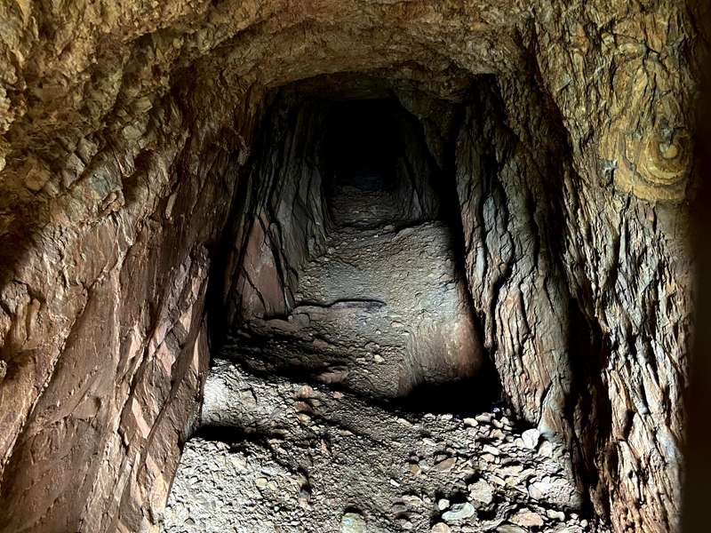
Follow the blue arrows. From the Hume and Hovell monument, a steep track will take you past the entrance of Reform mine and an old ventilation shaft that once serviced the mine. The loop continues in a southerly direction where more sheltered conditions enable flora such as Red Box and Long-leafed Box to flourish. The track returns past on old quarry, once used by the local shire to provide rock for the Myrtleford/Bright road.
Poverty Reef Loop (purple markers)
Return 1.5km, Short Hills, Clearly Sign Posted, Occasional Steps, No Experience Required
Follow the purple arrows. This loop starts and finishes at Poverty Reef, which can be accessed via the Lookout loop. This walk takes in the northern section of Reform Hill, formerly the site of the school pine plantation and has been replanted with native vegetation since 2011. The walk leads to an excellent lookout overlooking the Myrtleford township and the Ovens Valley.
Monument Walk (yellow markers)
Return 1.2km, Mostly Flat, Formed Tracks, Clearly Sign Posted, Occasional Steps, No Experience Required
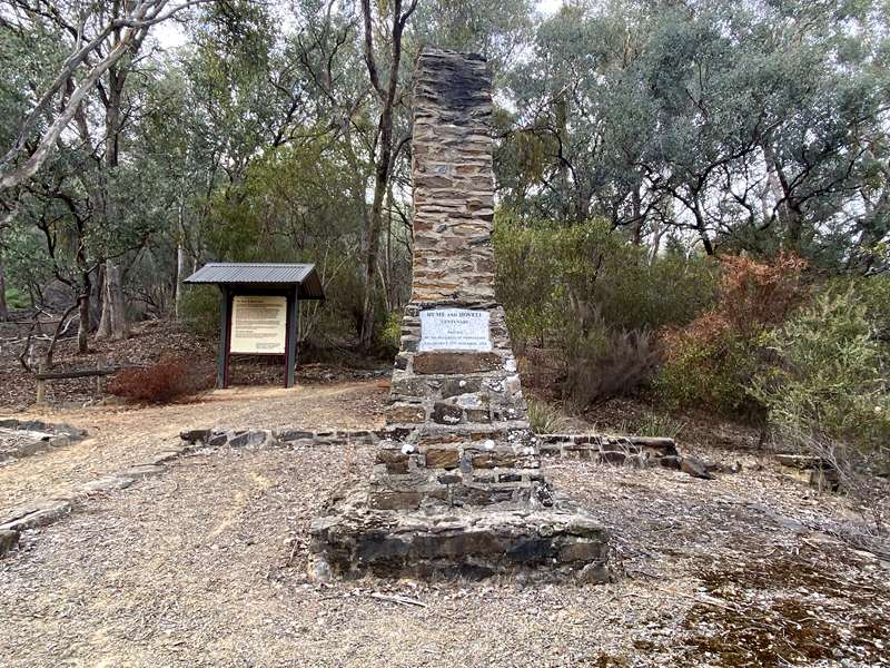
Follow the yellow arrows. The shortest and easiest of the three loops taking in the Hume and Novell monument and returning to Jones Reserve via the Murray to Mountains rail trail.
Location of Mosaics
Location of Threatened Species Mosaics
Interpretive Signage
There is interpretive signage across Reform Hill. See white numbers on the following map.
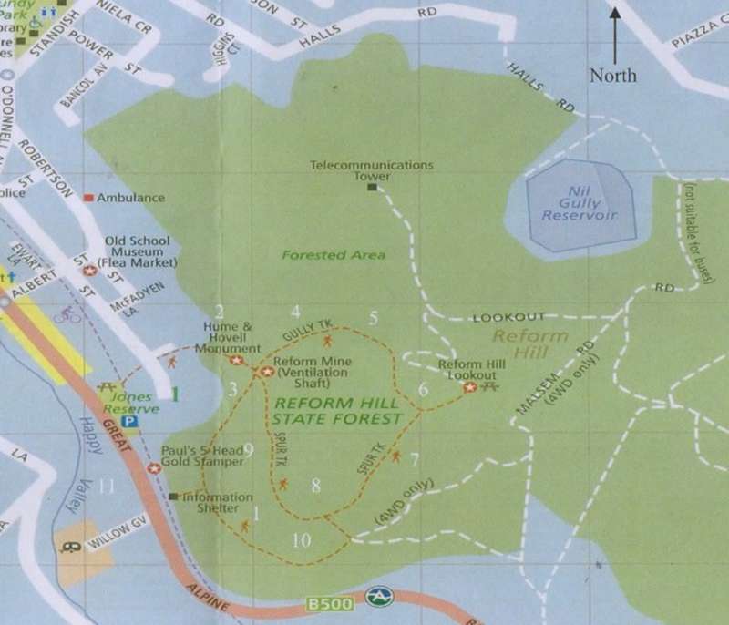
1. Indigenous people occupied the area for over 15,000 years.
2. Hume & Hovell Monument erected 1924 celebrates 100 years of exploration.
3. Mining in over 100 reef mines and alluvial deposits found in streams across the area.
4. This old reservoir built in 1934 was the first reticulated storage for Myrtleford.
5. A variety of eucalypts and native flora provide habitat for our native fauna.
6. Austral Grass Tree is a threatened species, flower spikes late spring and summer.
7. Native Flora at Reform Hill, flowers not only in spring but throughout the year.
8. Fauna habitat exists from the leaf litter to the tree tops.
9. Gold dredging in the early 20th Century. Local resistance kept disturbance of the riverine areas to a minimum.
10. The character of industry has left its mark in the Ovens Valley.
11. History tells of an era long gone with the old butter factory, 1903-1966.
About this Site
Gold!
Reform Hill takes its name from the rich gold-bearing quartz reef discovered in 1854. It is said that a shepherd came across gold-bearing specimens while grazing sheep on the hill. Following this discovery, trial crushings yielded a high proportion of gold (ten ounces to the tonne). The first owners of the Reform Reef were S. Lane, H. Collins, W Mitchell and J. Green. It was later sold to the 19th century tycoon J. A. Wallace. His brother was appointed manager of the mine and became a leading Myrtleford identity.
The Glory Days
To crush the quartz stone, the Reform battery was erected on the banks of the Happy Valley Creek, the stone was taken from the mine entrance and transported to the battery via a small rail system. The battery was powered by a waterwheel about 5 metres in diameter.
For over 30 years the Reform Mine was a principal employer within Myrtleford, with miners paid around 2 pounds 10 shillings per week in the 1880's. Charles Johnson wrote about the mine when he was 92 years old;
"The Reform had been the life blood of the district for a quarter of a century. I worked in it myself... down to a depth of 700 feet, in galleries up to 28 feet wide and probably 200 feet in length"
Hard Times
The mine closed in 1888 after a large amount of water flooded the shafts.
The mine's closure, coupled with the poor economic times across the area placed considerable hardship on many Myrtleford Families. Over the 34 years of its operation, It is estimated that the mine produced around 21,500 ounces of gold.
Today...
Reform Hill is a peaceful recreation area with visitors and locals enjoying the many activities available, including nature walks, picnicking, scenic driving and wildlife viewing.
Hume and Hovell Monument
Built in 1924 as a memorial to the great explorers, the Hume and Novell Monument was erected on the centenary of their journey through the valley below. It was said at the opening of the monument in 1924 that "The history of a hundred years was being written in stone to be handed down through the ages of future generations" (Myrtleford Mail, November 27, 1924).
Seats are provided at the monument and it also provides views across the township and along the Ovens Valley.
Special significance of Reform Hill Stony Bush-pea
The protection of Reform Hill has become significant In recent years due to the listing of the Stony Bush-pea as a critically endangered species. This small woody shrub, about 60-80cm high, can be found on the eastern slope of Reform Hill, along the south and east of Lookout Road. It has hairy leaves and flowers in spring with orange-red flowers. The Stony Bush- pea only grows in three known sites - Mount Tambo near Omeo, Mt Samaria near Mansfield and at Reform in Myrtleford.
Management for the future
The Stony Bush-pea regenerates by seed, and while fire promotes germination of the seed stored in the soil, all existing plants are killed by fire. Flowering begins at approximately 2-3 years of age, with full seed production occurring at 5-8 years of age Thus, a fire before the plants have produced sufficient seeds (0-5 years of age) is detrimental to the survival of the population.
Other Threats...
The Stony Bush-pea is also threatened by competition from weeds, which can be accidently introduced by traffic and the sediment deposition that comes from road maintenance.
Herbivore grazing threatens the survival of juvenile plants and new growth on older plants. Both native herbivores such as wallabies and kangaroos and introduced herbivores like rabbits graze on Stony Bush-pea.
Visitors, Friends and Special Residents - Visitors and Friends to the forest...
Along your way, look closely into the forest to see what other visitors may be enjoying the area. A small mob of Eastern Grey Kangaroos call Reform Hill their home, and they are often out feeding in the early morning or the late afternoon. In the warmer months, they can often be seen resting in the shade. You may also come across Swamp Wallabies, their darker colour camouflaging them between the trees. You might even spy an Echidna or two searching for food amongst the tree roots. Blue-tongue Lizards and Lace Monitors also roam around on the warmer sides of the hill. The many flowering trees and scrubs play host to a variety of colourful and chattering birdlife, including King Parrots, Crimson Rosellas and Gang-gang Cockatoos.
Reform Hill Lookouts
Reform Hill provides visitors with spectacular views of Mt Buffalo, the Ovens Valley and the Victorian Alps. Crops of hops give the valley its unique patchwork appearance. In winter, snow can be seen covering the peaks of the distant mountains.
Arrive at the summit lookout through the lookout loop track. This track showcases historical sites and features. Bench seats are provided for rest stops along the way.
A second lookout is accessed via Poverty Reef Loop. This picturesque lookout provides visitors with additional views of Myrtleford and the surrounding region.
Reform Hill Mosaic Trail
The threatened species mosaic trail is on initiative run by the Myrtleford & District Landcare & Sustainability Group. This trail is aimed at raising awareness for the threatened and endangered species found in and around Reform Hill While exploring Reform Hill, keep a look out for the wide eyes of a Barking owl or a sun basking Lace monitor.
BE CAREFUL! OLD MINE SHAFTS ARE STILL PRESENT IN THE AREA. PLEASE REMAIN ON WALKING TRACKS.
Photos:
Location
Jones Park, Murray to the Mountains Rail Trail, Myrtleford 3737 View Map


")