Myrniong - Heritage Trail

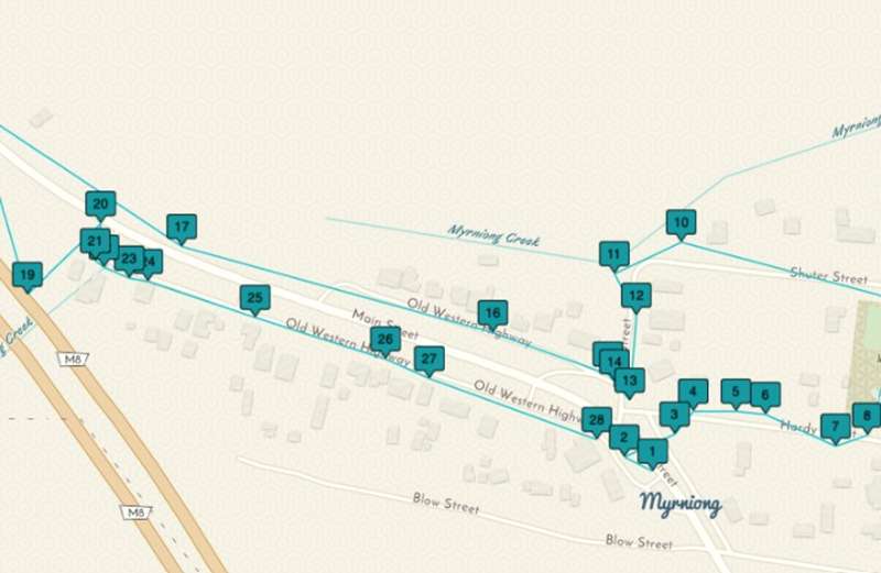
The Myrniong Heritage Trail explores the historic buildings, former businesses, community reserves and early settlement stories of this small Moorabool Shire township. The self-guided trail was created by local historian Ruth Mills and can be followed using an interactive online StoryMap containing historical photographs, maps and detailed stories.
Myrniong developed after Captain William Wootton Blow took up agricultural land in the Pentland Hills during the early 1850s. The fertile flats became known as Blow's Flat. The government surveyed the township for subdivision during the 1850s, and the name Myrniong appeared on government maps by 1854. Myrniong became the official town name in 1863.
Many of the surviving buildings are constructed from local bluestone and reflect the development of Myrniong as a stopping place, farming district and service centre.
Distance: No official distance is provided
Time: Allow at least 1-2 hours, depending on the number of stops and optional sections visited
Route: Self-guided township circuit with optional creek, highway-underpass, church and Mount Blackwood extensions
Start: Green bench seat on Main Street, Myrniong
Terrain: Streets, footpaths, roadside areas and an optional uneven creek-side track
Accessibility: No official accessibility grade has been published
Use the Myrniong Heritage Trail interactive StoryMap for the published trail order, maps, historical photographs and complete local stories.
Myrniong Heritage Trail Map
Important Route Information:
The "Old Western Highway" shown on the heritage map is the unsealed service road in front of The Plough. The adjacent sealed road is Main Street.
Take care when crossing Main Street and other roads. Some buildings are private residences and must only be viewed from the public roadside.
Heritage Trail:
1. Main Street View and Mount Blackwood
Begin at the green bench seat on Main Street. Looking ahead from this point, Mount Blackwood can be seen rising approximately 747 metres above sea level within Lerderderg State Park.
Mount Blackwood is an extinct volcano whose last eruption occurred more than one million years ago. The summit is not part of the town walking circuit, but it can be visited separately via Mount Blackwood Road and Lohs Lane. Check current park and road conditions before attempting this extension.
2. Historic Victorian Blue Gum
A large Victorian Blue Gum near The Plough is estimated to be as much as 210 years old. The tree predates the establishment of the township and is one of the trail's most prominent natural landmarks.
3. H. W. Simmons Post Office and Store
Henry and Catharine Simmons obtained the tender to operate the post office during the early 1860s. Henry Simmons constructed a substantial general store that also supplied building materials and obtained a refreshment licence in 1863.
The premises were expanded in 1869 so the family could carry a greater range of seasonal merchandise brought from Melbourne. The Simmons family operated the store for approximately 50 years.
4. Church of England
The Church of England received the largest of the three church allotments reserved during the 1850s survey. It was the only church within the surveyed township to be constructed from bluestone, possibly obtained from Dunbar's local quarry.
The foundation stone was laid on 25 October 1864 and the church formally opened on 22 December 1864. Its eastern stained-glass windows were produced by the important Melbourne firm Ferguson and Urie and date from the original period of construction.
The church remains in religious use, with services conducted through the Bacchus Marsh Anglican parish.
5. Roman Catholic Church Site
This stop marks land allocated for a Roman Catholic church during the 1857 town survey. No church was ultimately constructed on this allotment.
The church serving the district was instead erected at Korobeit in 1864 on land purchased from Lady Clarke. It was replaced by the present brick Our Lady Help of Christians Church in 1925.
The surviving church is approximately 4.5 km west of Myrniong at 309 Myrniong-Korobeit Road, Korobeit. It is an optional driving extension rather than part of the central walking circuit.
6. Presbyterian Church Site
The town survey also reserved an allotment for a Presbyterian church, but the congregation built elsewhere after the widow of early landowner Charles McLachlan donated land closer to the centre of the village.
Before the church was built, services were held at John Thomas' flour mill towards Mount Blackwood. The foundation stone was laid on 20 September 1861 by Thomas' wife, although the stone has since been lost. The church opened during November 1862.
The former church building stands at 136 Old Western Highway, Myrniong. Its stained-glass windows were dedicated to members of the local community. The building was sold in 2019 after being condemned and should only be viewed from public land.
7. Myrniong Primary School
Myrniong Primary School opened as Blow's Flat National School on 1 October 1859, with Nicholas P. Webbe as its early head teacher. It later became Myrniong Common School and then Myrniong State School during the 1870s.
The school remains open as Myrniong Primary School No. 487.
Address: 13 Muddy Lane, Myrniong
8. Myrniong Recreation Reserve
This land was originally set aside as a cemetery during the 1856 survey, but the cemetery was never developed. During the late nineteenth century, the area hosted ploughing matches, agricultural shows and other community gatherings.
The reserve now contains:
- Public toilets
- Drinking water
- Picnic shelter
- Barbecues
- Playground
- Outdoor exercise equipment
- Tennis courts
- Sports oval
9. Charles Cowan Story
Scottish brothers Charles and James Cowan arrived in Melbourne in 1853 before travelling to Bacchus Marsh to work at James Young's flour mill.
Local family stories claim that the brothers walked from Melbourne and arrived before breakfast, although later generations joked that nobody had recorded what time breakfast was served.
10. Jim Barry Reserve
Jim Barry Reserve follows Myrniong Creek behind the row of houses. Jim Barry arrived in Myrniong in 1928, married Roma and raised five children in the district.
Following his retirement from Southern Rural Water, Barry began clearing rubbish, mowing grass, planting trees and maintaining the creek corridor for the community. A young local resident, Richard Wignell, helped with this work. A plaque and commemorative tree recognise his contribution following his death in 1997.
The reserve provides a quiet alternative to the roadside trail, but the ground is undulating and snakes may be present. Wear suitable footwear and remain alert around long grass and the creek.
11. Mechanics Institute Hall
Myrniong's original Mechanics Institute Hall was constructed from bluestone in 1870. A major fire destroyed the building in 1930.
The hall was rebuilt in weatherboard and reopened the following year. It continues to be used for meetings, functions and community activities.
Address: 6 Short Street, Myrniong
12. Hardy Street
Hardy Street was named after John Hardy, who surveyed the early Myrniong township in 1854.
13. Myrniong General Store
Jim and Helen Lennox took over the Myrniong General Store in 1961. The business served local residents and visitors travelling to Pykes Creek Reservoir and closed only on Christmas Day and Good Friday.
Helen Lennox combined work at the store with extensive community service, including roles with the school mothers' club and hospital auxiliary. Jim Lennox served as a councillor and became Shire President of Bacchus Marsh in 1967.
The couple sold the store in 1976.
14. Earlier Local Store
The local store was once licensed to sell gunpowder and poison. Three external shutters communicated whether the store was open and also served an unusual community purpose.
When all three shutters were closed, the business was shut. When only the centre shutter was opened, information about a recent local death was displayed in the window.
Mr Paterson operated the business briefly during the late 1950s before selling it to Jim and Helen Lennox.
15. The Dawson Family Story
Charles and Bridget Dawson lived in this part of Myrniong during the late 1850s with their four young children.
Their circumstances changed in August 1862 when Charles sought improved employment opportunities. The full StoryMap recounts a chance sighting that affected the family's future and provides a distant connection with the story of Ned Kelly.
16. Myrniong War Memorial
The Myrniong War Memorial commemorates local servicemen and women who served during the First World War, Second World War and later conflicts.
The memorial consists of a substantial red-brick wall carrying commemorative plaques.
17. Avenue of Honour
Myrniong's original Avenue of Honour was planted on 9 August 1918 to recognise local men who enlisted during the First World War. Poor weather meant only three trees were planted during the official ceremony, honouring those who had died.
The avenue was subsequently extended and also included trees honouring Second World War service. Fifty Scarlet Oaks were planted in 2001 to replace the avenue along the western approach to Myrniong, although many later suffered poor health and required replacement.
The commemorative landscape has therefore changed considerably since the original 1918 planting.
18. Western Highway Underpass
An optional trail section passes beneath the Western Highway to the other side of Myrniong.
This is not required to complete the main township circuit. Check track and weather conditions before entering the underpass, particularly following rain, and supervise children closely.
19. Myrniong Bridge
The former road bridge across Myrniong Creek was constructed by the Country Roads Board in 1928. Sandstone abutments may survive from an earlier timber bridge dating from the 1860s.
The reinforced-concrete structure demonstrates the changing transport needs of Myrniong and is an intact local example of Country Roads Board bridge construction from the 1920s.
20. 1859 Store and Dwelling Site
Alfred Smith purchased strategically located allotments at both the eastern and western entrances to Myrniong.
He constructed a combined store and dwelling at this location during the 1860s.
21. Former Milk and Cheese Factory
The residence and former factory at 61 Main Street are associated with the development of dairying and agricultural processing in the Bacchus Marsh district.
American settler G. G. Pierce constructed the timber-framed factory and adjoining Victorian residence around 1877. The premises operated as a cheese factory from 1877 until 1892 and subsequently as a milk factory until 1942.
Address: 61 Main Street, Myrniong
22. John Swannell's Butcher Shop Site
John Swannell constructed a butcher shop at the western end of Myrniong during the mid-1860s. The building no longer survives.
The shop was demolished after Swannell left Myrniong for Ballan in 1869, where he took over the licence of the Commercial Hotel.
23. Former Myrniong Hotel
John Tyson built the Myrniong Hotel at the western end of the township in 1865 on land owned by local butcher John Swannell, who became its first licensee.
When Swannell moved to Ballan in 1869, Tyson purchased the hotel and sold his blacksmithing business to Philip Purcell.
The former hotel is now a private residence. Remain on public land and respect the privacy of its occupants.
24. Girraween Blacksmith and Wheelwright
This bluestone building was constructed in 1867 for blacksmith and wheelwright George Drysdale. Drysdale worked in partnership with John Tyson after a shortage of water encouraged them to move their business into the township.
The former residence is a rare surviving example of an 1860s bluestone dwelling. Architectural details include dressed stone quoins, tuckpointed bluestone walls, a verandah extending from the main roof, paired chimneys and a four-panel timber entrance door.
The building is a private residence and should only be viewed from the public roadside.
25. Petrol Station, Store, Post Office and Newsagency
This former business operated as a petrol station and general store. It also accommodated the Myrniong Post Office and newsagency during part of the period from the 1960s to the 1990s.
26. Police Station and Gaol
The former police station and gaol were constructed by John Swannell in 1870 and were the second buildings used for law enforcement in Myrniong.
They served as a police station and gaol for only seven years, closing in 1877. The former police station is an early bluestone civic building, while the sandstone gaol at the rear is a rare surviving example of a small nineteenth-century lock-up.
The property is now a private residence. Do not enter the property or attempt to view the gaol from private land.
27. The Plough Inn
The Plough Inn was established in 1861 after storekeeper Alfred Smith relocated his business from a site farther east along Pentland Hills Road.
The original inn was a weatherboard building with extensive stables for travellers' horses. A major fire destroyed the hotel, stables and horses in 1901.
Publican John Foley rebuilt the hotel within several months, using bluestone recovered from the demolished Ballan Hall. His sister Kate became the licensee when the reconstructed hotel opened late in 1901 and continued managing the business until retiring in 1945.
The bluestone hotel remains an operating restaurant and is an appropriate finishing point for the heritage circuit.
Address: 17 Main Street, Myrniong
Facilities:
The main public facilities are located at Myrniong Recreation Reserve on Hardy Street:
- Public toilets
- Drinking water
- Picnic shelter
- Barbecues
- Playground
- Outdoor exercise equipment
- Tennis courts
- Sports oval
Accessibility:
The trail does not have a published accessibility grade. Central stops are viewed from public streets, footpaths and roadside areas, but surfaces and kerb crossings may vary.
Jim Barry Reserve has undulating natural ground and may not be suitable for wheelchairs or mobility aids. The Western Highway underpass and optional Mount Blackwood extension are also unsuitable for inclusion in an accessible town circuit without further assessment.
Visitors requiring an easier route can drive between the principal roadside locations and omit the creek reserve, underpass and other uneven sections.
Access for Dogs:
No specific dog-access rules are published for the complete heritage trail. Dogs should be kept on a lead around streets, heritage places and other visitors. Follow current signs at Myrniong Recreation Reserve and Jim Barry Reserve.
Important Information:
- Some heritage buildings are private residences and must only be viewed from public land
- The Roman Catholic and Presbyterian church stops include original township sites where no church building remains
- The surviving Roman Catholic church is at Korobeit and requires a separate drive
- Take care when crossing Main Street and other roads
- The Jim Barry Reserve track has undulating ground and snakes may be present
- Check conditions before using the Western Highway underpass
- Do not enter private property to inspect the former hotel, blacksmith's residence, police station or gaol
- No official distance, walking time or accessibility grade has been published
- The trail begins at the green bench seat on Main Street, Myrniong
Opening Hours:
The public streets and outdoor heritage locations can be visited at any time. Access to churches, The Plough and other operating or privately owned buildings depends on their individual opening arrangements.
Cost:
Free.
Location
Main Street, Myrniong 3341 View Map
Web Links
→ storymaps.arcgis.com/stories/07da873f82f84b2c8d36b668160be91b


