Mount Miller Walk (Tremont)

.jpg "Mount Miller Walk (Tremont)")
Mt Miller, at an altitude of 402m overlooks Ferntree Gully. It has an interesting history. In 1888, local landowner, John Martin, had a remarkable dream. He would build a small rack railway part-way up the slopes of One Tree Hill, started about 500m east of the rail station in The Glen and ending at a grassy knoll known as Mt Miller, named after Thomas Miller, a fellow Ferntree Gully landowner whose house survives today.
Like a proposed tramway from Bayswater to Olinda in the same year, collapse of the land boom a few years later put paid to the dream.
This 4.9km walk encompasses his 'mountain of dreams'. Keep an eye out for wallabies and there are plenty of birds such as kookaburras and cockatoos.
Mount Miller Walk Map
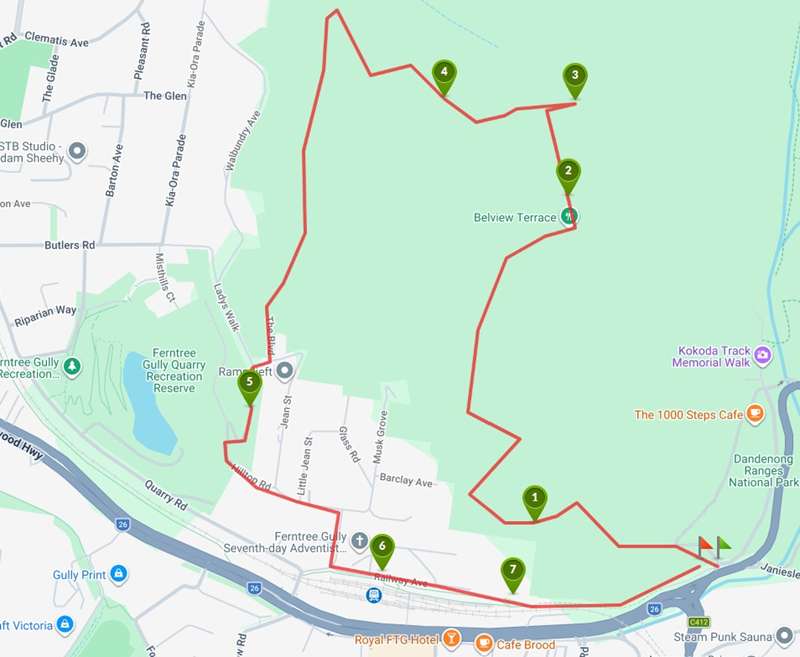
Interactive map
Points of Interest
The route follows Belview Terrace uphill on a wide gravel road. At the intersection with School Track there is 'Storm Leaves' sculpture which is part of the ngurrak barring Art Trail.
-embed01.jpg)
1. Scenic view
Belview terrace is a steep climb, but there are excellent views to the south across Lysterfield to the Mornington Peninsula beyond.
The climb progressively becomes steeper and the walk is punctuated by interesting Indigenous information signage with the theme of resilience. Many of the signs are about the "The Seven Seasons of the Eastern Kulin Nation".
-embed02.jpg)
There are a couple of seats beside the path beckoning for you to take a rest. As you get closer to the top, the bush has been cleared beside the track and there is a good chance to see wallabies.
2. The Boulevard
A very rusty steel and concrete fence on the right is not the garden of some long forgotten house. It's the boundary fence of the former Ferntree Gully Zoo, dating from the 1940s.
3. Mount Miller
The actual summit is about 50m east of the track. On a clear day, there good views through the trees, including the city to the west, and Mt Macedon to the north-west
4. Lantern track
Lantern track is more gently graded and quieter than The Boulevard, with fern gullies and wildlife, only 1 km from Ferntree Gully station.
Update: We could not find Lantern Track on any major map except a Bushwalking Blog map. The track is marked by a big pile of rocks beside the road. The track itself was more interesting than The Boulevard but very rocky and definitely not graded. The track comes out at the intersection of The Boulevard and Feather Track. Continue straight on along The Boulevard.
-embed03.jpg)
5. Kerrs quarry
There are obstructed views from the lookout tower at the top of the quarry. The quarry has been converted into a recreational precinct, Ferntree Gully Quarry Recreation Reserve, with a playground and fishing jetties. There is no access from this side of the quarry.
-embed04.jpg)
6. Upper Ferntree Gully rail station
This was the terminus when the line opened in 1889, and starting point for 'Puffing Billy' for many years. Part of the walking track back to the start are on the old rail right of way.
-embed05.jpg)
The trail passes the Upper Ferntree Gully CFA Fire Station. On the side of the fire station is a huge mural. Painted in 2014 by Melbourne street artist ASKM, the mural honours generations of volunteer firefighters through portraits, historic firefighting scenes and bush landscapes, alongside the words "Volunteers Serving the Community." It serves as a lasting tribute to the brigade's role in protecting the Dandenong Ranges and its community.
-embed07.jpg)
Cross the train track (carefully) and enjoy the beautiful images of a Scarlet Robin and Australian King Parrot painted on the water tank by Jimmy Dvate in 2025.
-embed06.jpg)
7. Upper Gully primary school
This grassy slope was the site of Upper FT Gully primary school until the school moved to Talaskia Rd in 1963. Kids could watch 'Puffing Billy' laboring up the slope from their playground.
Access for Dogs:
Dogs and cats are not permitted. Horses and trailbikes are also not permitted.
Photos:
Location
School Road, Tremont 3785 View Map
Web Links
→ Mount Miller (Walking Maps)


")