Mount Beauty - Gorge Walk


Walk through tranquil bushland to the entrance of a small canyon on the Kiewa River's west branch.
Distance / time: 3.8 km / 1 hr 15 min
Grade 3: Some experience recommended. Formed track with some steps and obstacles. Signposted.
Start on the dirt road opposite the Visitor Information Centre and follow it to the river. The trail heads south along the river ending at a small canyon. Only strong swimmers should attempt to wade into the canyon, and only when water levels are low. Return the same way.
Warning: This river forms part of the hydroelectric scheme. Water levels may rise rapidly at any time. Also watch out for snakes in warmer weather.
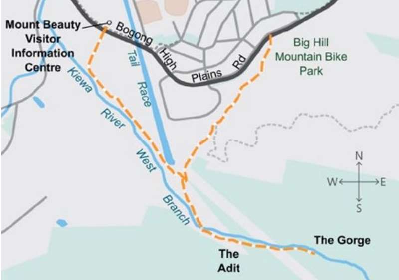
Mount Beauty Gorge Walk Map
Kiewa River Catchment
The "West Kiewa" River is joined by the "East Kiewa" River just downstream of Mount Beauty township. These streams form part of the upper Kiewa River catchment which starts in the alpine landscapes of the Great Dividing Range (around 1600 m high), southeast of Victoria s highest mountain, Mt Bogong.
The West Kiewa River is largely unregulated. The East Kiewa River is controlled by a water storage at Lake Guy in Bogong Village which is part of Victoria's largest hydroelectric scheme. There is also a Regulating Pondage in Mount Beauty township. Leaving Mount Beauty, the Kiewa River flows north along a widened valley dominated by agriculture, passing the localities of Gundowring, Kergunyah, Dederang. The lower reaches of the Kiewa River drain across a wide floodplain characterised by many wetlands, anabranches and billabongs before it enters the Murray River near Albury-Wodonga.
Review:
An interesting walk with the Canyon at the end being an adventurous highlight.
The walk starts from across from the Visitor Information Centre (on the south side of the Bogong High Plains Road). You can either park in the car park along Bogong High Plains Road or drive a short distance along the road past the Electrical substation to a carpark. At this carpark there is a sign "Carol's Track" which leads down to a seat which overlooks the Kiewa River West Branch.
To start the Gorge walk head along the road running between the the Electrical substation and the river. the route is very well signposted. Initially the wide track passes through tall gum trees. You will come to a massive water holding area on the left.
Soon after the track comes to a T-intersection. To the left there is a track back to town via Big Hill Mountain Bike Park / Pole Track. Stay on the Gorge Walk track.
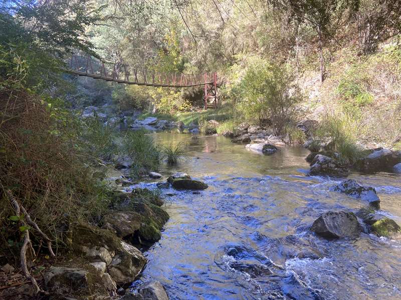
At the 1.2km point there is a wobbly suspension bridge and picnic table. There is also a swimming hole here plus another one 100m upstream. Please note that the West Kiewa Power Station Diversion is located upstream. Remote operation of the river diversion upstream can occur without warning. Substantial increase in stream depth and flow can occur, irrespective of weather conditions. For your safety, if water levels begin to rise return to a higher point. Also there is no mobile phone service past this point.
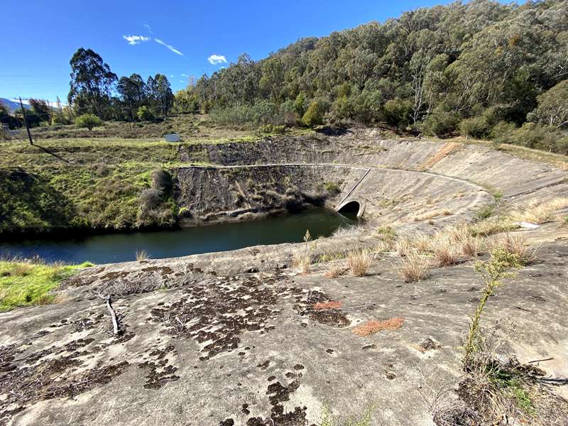
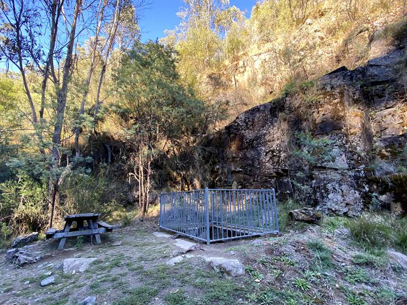
The track passes the "Don't Look Up Rock" and at the 1.7km point after passes an adit shaft with a picnic table. This shaft, the West Kiewa Shaft, is also known as the adit, was excavated in 1948 - 1949 by the State Electricity Commission to intersect the two kilometre long tailrace tunnel that extends from the West Kiewa Power Station to the Mt Beauty Regulating Pondage.
During construction of the tunnel, a major collapse occured at the Mt Beauty end, which blocked the tunnel and threatened to seriously delay the project. The shaft was excavated to a depth of 33 metres to enable the tunnel excavation to continue on a second face. A single lane road was built to the top of this shaft and the walking track follows the old road. A bridge was constructed across the river, near where the pedestrian bridge is now located. Excavation of the tunnel reached the base of the shaft in July 1950 and as the shaft had served its purpose it was backfilled with rock, which has settled over the ensuing years.
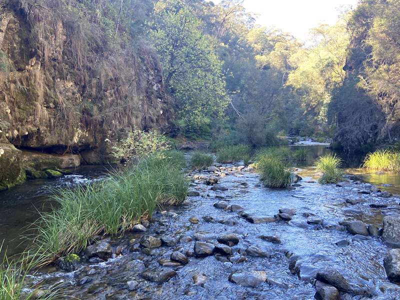
A bit further along, you reach the start of the 150m walk upstream to the Canyon. This requires crossing the river four times. A sign advises to proceed cautiously as many rocks are loose and some are slippery. It is not advised to proceed past this point when the rocks are wet.
During the warmer months, when the rocks in the river bed are dry, it is possible to walk and wade the 400 metres upstream to an impressive canyon. Once at the canyon, the best views and photographs can be obtained from within the canyon, where a pleasant swim can be enjoyed in crystal clear water. The best time of day to visit the canyon is during the late afternoon, when the sun is shining on the water. Walkers should be surefooted and prepared to get wet feet. Do not attempt this walk if the river is flowing strongly, be on the lookout for snakes in summer and take care with the slippery rocks.
We did the walk in late April and there were some trails of rocks sticking out of the water. A lot of people were trying to get to the Canyon in bare feet. It's not easy with freezing water and slippery and loose rocks under foot. It's very easy to lose your balance. I think the easiest would be to bring along some spare shoes so that you can walk across the water with more stability.
On the way back, the map indicates diverting back through the Big Hill Mountain Bike Park. However then you have to walk along Bogong Avenue back to the car park. We found it better to retrace our steps which makes the walk 4.2km return.
Access for Dogs:
Dogs are permitted on leash.
Photos:
Location
31 Bogong High Plains Road, Mount Beauty 3699 View Map


")