Mornington Peninsula Coastal Walk (Cape Schanck - Portsea)

The Coastal walk along the southern side of the Mornington Peninsula offers spectacular scenery stretching 30 kilometres between Cape Schanck and the Point Nepean National Park. The Coastal Walk encompasses many smaller sections of ocean beach walking trails, some along gravel tracks and parts along the sandy beaches. It changes from rugged rocky ocean coast at Cape Schanck to dense coastal vegetation along the way and finally to the famous sandy surf beaches through Rye and Sorrento. There are several sections that can be completed seperately as shorter walks if desired.
Although this walk can be done in either direction, more spectacular views are provided when walking west from Cape Schanck to Point Nepean as you get views along the length of the Bass Strait coast.
The start point is Cape Schanck Lighthouse at 420 Cape Schanck Road, Cape Schanck. The end point is London Bridge Road in Portsea.
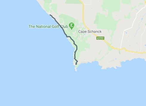
Cape Schanck to Gunnamatta Surf Beach section: (4.5km)
Leaving the Cape Schanck Visitor Area car park, follow the sealed Cape Schanck Road for 600m back towards Boneo Road. Turn left onto the dirt track which leads into the national park. Follow the walking track through coastal Moonah woodland towards Fingal and Gunnamatta Beach. A detour circuit walk provides access inland to Fingal Picnic Area car park, drinking water and toilets. Further north a side track leads to secluded Fingal beach via a long path of steep stairs. If you visit the beach, be sure to return to the high track as through access to Gunnamatta is difficult along the beach, especially at high tide. The main track passes through dense coastal vegetation with three spectacular lookouts along the way. When the track drops down onto the eastern end of Gunnamatta Beach, continue along the beach to the day visitor area containing the Surf Lifesaving clubhouse, car park and public toilets.
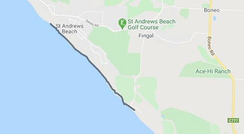
Gunnamatta Ocean Beach to Rye Ocean Beach section: (3km)
Cross Gunnamatta car park to the far corner, and take a link track which provides access past a second smaller car park and toilet and out onto the main entry road where the track turns left down to the beach. This section between Gunnamatta Beach and Boag Rocks to the west is along the beach. Tracks are mainly soft sand. Upon reaching Boag Rocks, proceed up the sealed road for 150m to the stairs which access the shared walking track and horse trail. Heading back onto the beach, this long stretch of beach walking passes inland escape routes to St Andrews Beach car park, Moana Court and Ocean Drive before finishing at Rye Ocean Beach car park with toilet facilities and drinking water.
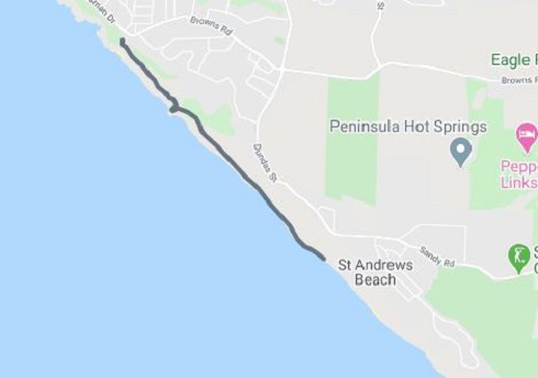
Rye Ocean Beach to Number 16 Beach section: (4km)
From Rye Ocean Beach continue along the beach past Gunida Court and Alison Avenue inland tracks and around two small headlands. A red-capped post in the dunes indicates the start of the track leading off the beach (approx 2.5km west of Rye car park). The cliff top track meanders along the rugged coastline past the sandstone outcrop of Lizard Head and the intersection of the inland track to Brewster Road before descending onto beach. Continue along the beach past Avon Road and Heyfield Road exits to reach the eastern end of No. 16 beach. Follow the red-capped posts through the dunes along the way. Further along the beach, a set of stairs access the track to the No. 16 car park.
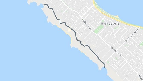
Number 16 Beach to Bridgewater Bay section: (6km)
Proceed 100m along the road out of the No. 16 car park and the historic Lifesaving Track heads off in to the dense bushland. This is the next section of The Coastal Walk and is a fascinating walk in itself. The 11km Lifesaving Track was built in the 1890s to provide better access to the coast after two devastating shipwrecks. There were 16 strategic points set up along the track as launch sites for rescue operations should ships became distressed. The track passes two inland exits at Carslake Avenue and Tibir Street before reaching picturesque Dimmicks Beach. Continuing on, it traverses sand dunes and spectacular cliff tops as it passes the Pearse Road and Royadie Road exits before reaching beautiful Bridgewater Bay. At this point a circuit walk gives access to St Johns Wood car park and a detour to the intriguing rock pools of Bridgewater Bay, access is available via a steep staircase.
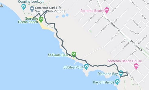
Bridgewater Bay to Diamond Bay section: (5km)
Starting at Bridgewater Bay, continue on the Lifesaving Track to Spray Point. A short detour provides access to Spray Point, a spectacular headland with views over Koonya Ocean Beach and back towards Diamond Bay. The Lifesaving Track continues on to Koonya Ocean Beach passing a car park and toilet block at Hughes Road. From the western corner of Koonya lower car park the track leads towards Diamond Bay, a scenic detour circuit can be made at Dog's Head west of Koonya. The Coastal Walk passes yet another scenic detour at Jubilee Point which, on a clear day, provides spectacular views of Cape Schanck to the east and as far as the Otways to the west. The walk finishes at Diamond Bay.
Coppins Walk Track section: (3 km)
Coppins Track runs between Diamond Bay and Sorrento Ocean Beach. It is a 3km guided historic walk that winds along the cliff tops tracing the history of the area over the last 100 years. The track follows sections of the original 1800s limestone paved footpath. Numbered pegs along the track correspond with the Coppins Track Park Note and lead you to several lookouts with spectacular coastal scenery. A circuit walk east of Diamond Bay provides access to historic St Pauls Lookout, a strategic observation site for the early settlers and gives stunning views over the Bay of Islands. Continuing west for 1km, follow Coppins Track past the steps to St Pauls Beach and on to Sorrento Back Beach where there are toilets, drinking water, a Surf Lifesaving clubhouse and cafe.
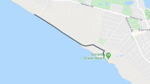
Sorrento Ocean Beach to Portsea Ocean Beach section: (2km)
Crossing the road at Sorrento Back Beach, the path travels through the vegetation above the car park and beach (an alternative track from the Surf Lifesaving clubhouse connects back up with the main track above via Coppins Lookout). A short detour to Websters Lookout gives stunning views over the township of Sorrento and Port Phillip Bay. An escape route is available which leads past the Sorrento Cemetery to Normanby Road. Follow the main track past the lookout and descend the stairs to the eastern end of Portsea Surf Beach. The route now proceeds along this scenic stretch of beach, past the Franklin Road escape route, to the ramp at the Portsea Surf Lifesaving clubhouse, toilets and drinking water.
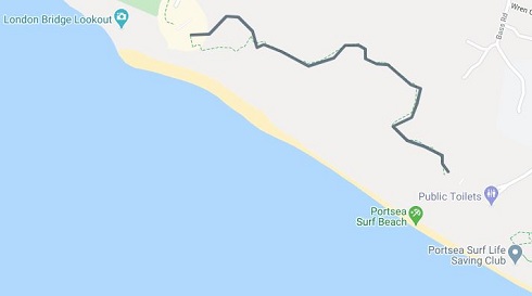
Farnsworth Track section: (1.5km)
The Farnsworth Track is part of the 26km Coastal Walk and links Portsea Surf Beach with London Bridge along cliff tops via two scenic look outs. The walk is identified on signage by the round Hooded Plover symbol. Alternatively, complete a round trip by walking along the track and the beach. The beach section is best attempted when the tide is out but can be completed when tide is high by walking on narrow strip of soft sand. The track, built in 1987 with a donation from the notable local Farnsworth family, links Portsea Surf Beach with London Bridge along the cliff tops via two scenic lookouts. At London Bridge, a steep ramp leads to the beach where amazing rock pools are visible at low tide. A public toilet, drinking water and lookout are available at the car park.
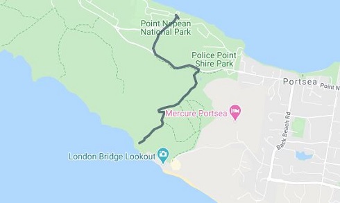
London Bridge to Point Nepean National Park extension: (3km)
While London Bridge can be construed as the end of The Coastal Walk, a pleasant extension through coastal Moonah woodlands leads into neighbouring Point Nepean National Park. The track passes Wilsons Folly and comes out on Defence Road. This trail takes walkers from the rugged Portsea Ocean Beach and London Bridge rock formation, back to civilisation at the Point Nepean Road side of the Mornington Peninsula. Visitors can continue along the walking track to the Quarantine Station and onto the historic forts of the Point Nepean National Park, or link to the Portsea section of the Mornington Peninsula Bay Trail.
Access for Dogs:
Dogs are banned from the Mornington Peninsula National Park to provide greater protection for the park's vulnerable fauna as it is home to more than 32 fauna species of significance including the threatened Hooded Plover, migratory shorebirds, marsupials including the White-footed Dunnart and the Long-nosed Bandicoot, and reptiles such as the Blue-tongued Lizard.
Many of these species are susceptible to dog attacks and even the scent or barking of dogs can cause distress.
Location
420 Cape Schanck Road, Cape Schanck 3939 View Map


")