Mooroopna - Aboriginal History Walk


This walking tour will give you the chance to walk some of the tracks in the area known as the ‘Flats’ located between the Peter Ross-Edwards Causeway and the Goulburn River on the south side.
Start / Finish: Chinaman’s Garden Reserve.
Distance: 4.3km. Follow the path outlined on the map and note signage throughout the walk.
Surface / Access: The walk is on both a sealed bike path (Yahna Gurtji Shared Pathway) and unsealed forest tracks and therefore not completely accessible due to the uneven ground and undulations on the forest track.
Mooroopna Aboriginal History Walk Map
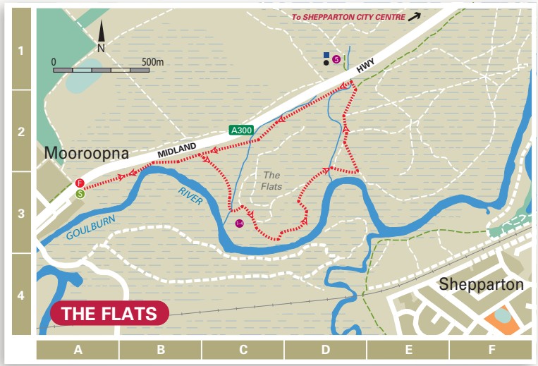
Points of Interest (shown on map):
1 The establishment of an Aboriginal community in this area by the Yorta Yorta families was a direct result of the Cummeragunja ‘Walk Off’ on 6 February 1939.
2 This particular site was chosen, as the Yorta Yorta had an extended traditional association with the environments in close proximity to rivers such as the Kaiela (Goulburn River).
3 A September 1946 police report listed 130 people aged from 8 days to 80 years living on the ‘flats’ with a third of them less than 15 years of age. Lodgings consisted of 29 dwellings, 22 being assortments of tin or hessian bag huts and the rest tents.
4 The river provided abundant food including crayfish, red fin, yellow belly, cod as well as possum, turtle, turtle eggs, swan, duck, crane and other birds and their eggs. The women predominantly fished whilst the men would hunt for rabbits.
5 Every year the river would flood, causing the residents to move to higher ground on Daish’s paddock, now home to KidsTown Adventure Playground.
Walk Note: Extra care needs to be taken when walking in the forest area. Please ensure you remain on the designated tracks and respect the area and its history. Track may not be accessible in times of flood.
Hazards: Be aware of snakes during the warmer months.
Web Links
→ Walking in Greater Shepparton Brochure


