Mirboo North - Grand Ridge Road Scenic Drive


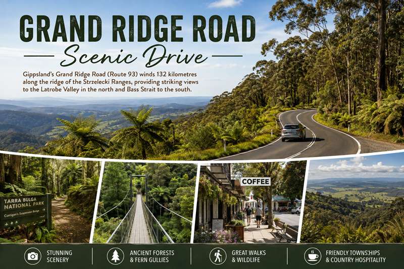
DRIVING THE GRAND RIDGE ROAD
Gippsland's Grand Ridge Road is one of Victoria's greatest touring drives.
The 132km road snakes its ways along the ridge of the Strzelecki Ranges providing stunning views across the Latrobe City. It passes through or near Mount Worth State Park, Mirboo North, Balook and Tarra-Bulga National Park. Mirboo North is roughly the halfway point.
Driving along the road you will be engulfed in cool temperate rainforest and surrounded by towering trees and then emerge into sunlight for another breathtaking view of a sweeping valley more spectacular than the last. Much of the road is unsealed and it is advisable that you have a map to help guide you on your journey along the Grand Ridge Road.
Places of interest along the way include Tarra Bulga National Park noted for its lush green fern gullies, towering mountain ash and the famous suspension bridge. Boolarra, located in the foot hills of the Strzelecki Ranges, this small country town is host to the Boolarra Folk Festival each year and has accommodation available if peace and tranquillity is what you crave. Mirboo North, known as the capital of the Grand Ridge Road, marks the approximate half way point of the 132km journey. Visit the Grand Ridge Brewery, sample some locally produced beer and have a meal or try one of the local bakeries for a hot pie or fresh bread roll.
Mt Worth State Park once stripped of its beauty by the timber industry now comprises natural forest, regenerating bush and cleared pastures.
Take the time to explore Mirboo North mid journey and enjoy their lively cafés and restaurants, purchase home-made produce from the local stores or enjoy the country hospitality at the local eateries.
The natural splendour of the route is seen at its best in the Tarra Bulga National Park, famous for its dense mountain gullies, towering Mountain Ash, suspension bridge and wildlife including the elusive lyrebird.
The Grand Ridge Road (Route 93) is a majestic drive. Visitors should allow five to six hours to complete the drive comfortably or spread the drive over a few days to enjoy Mirboo North, the surrounding towns and the wildlife and nature experiences along the way.
Travelling between Warragul - Korumburra Road in Seaview and the Hyland Highway in Willung South, the Grand Ridge Road can be explored in either direction.
It can be reached via Warragul, Morwell or Traralgon from the Princes Freeway, or via Yarram, Foster, Korumburra or Leongatha from the South Gippsland Highway and takes between 20 to 30 minutes to access the road via any of these towns.
It is a beautiful, yet windy 132 kilometre mix of sealed and gravel roads, so it's a good idea to know your vehicle and what it can handle. Some sections are not suitable for caravans or vehicles with a low clearance.
Cautious travel is recommended. Be sure to stay within the speed limit, choose an appropriate speed for the driving conditions and keep to the left as the majority of the road does not have centre lines for guidance. It is advised to keep your headlights on for greater visibility. Weather-related hazards on the road can occur at any time, tree debris may fall on roads and surfaces can be slippery or corrugated. The road runs through a high rainfall area and is often wet, slippery and foggy. On very rare occasions you may also experience snow.
Look out for native animals straying onto the road near sunset and sunrise. Be aware that logging trucks and other heavy vehicles also utilise this road and caution is required.
Carry or download a map and follow it carefully as sign damage may be a problem along the road and mobile reception in some areas can be poor or unavailable.
It can be easy to get lost trying to navigate off the Grand Ridge Road so we suggest the use of the “additional exit points” detailed in this brochure.
Most importantly, plan ahead. Make sure you allow extra time to get to your destination, including rest stops and time to explore the towns and state and national parks along the way.
Be sure to check road closures and notifications and weather conditions before travel. Travel steadily and carefully and you will enjoy one of Victoria's great touring experiences.
HISTORY
Although Polish explorer, Paul Edmund ‘Count’ Strzelecki endured a 22-day struggle through the dense mountain forest of South Gippsland in 1840, the beauty of the region did not escape his attention.
The pioneers who followed had to fell 90 metre trees and clear dense forest to make a living from the slopes. Many became lost whilst trying to clear their runs. The backbreaking work of two generations of settlers cleared much of the original Mountain Ash, but was soon reclaimed by the bush in the eastern Strzelecki Ranges.
At the western end, life was slightly easier and today’s magnificent vistas of soft, green farming valleys are the legacy of their perseverance.
During the 1930s the Forest Commission began a program of reforestation with a camp on the Morwell River. Later, the camp became a minimum security prison, before closing in 1997.
The Mount Worth State Park is one of the few uncleared bush areas left in the western Strzelecki Ranges, while the Tarra Bulga National Park is a cherished remnant of the magnificent mountain forests, which once covered the whole range.
FLORA & FAUNA
Flora
The vegetation of the Grand Ridge Road is predominantly wet sclerophyll forest. Dry sclerophyll forests are quite common on the Australian continent but wet sclerophyll forests are quite rare.
The wet sclerophyll have a tall overstory of 30 metres or more and are generally comprised of Mountain Ash, Alpine Ash, and Manna Gum Eucalypt varieties. Mountain Ash can grow to a mature height of over 90 metres and are the dominant species along the Grand Ridge Road.
The understory is typically soft leaved with tree ferns particularly prevalent. There have been 39 species of tree fern recorded in the Tarra Bulga National Park alone. This type of forest requires a relatively high yearly rainfall of at least 1,000 millimetres.
Fauna
The Grand Ridge Road crosses through a variety of forest and farming areas, which accounts for the diverse mix of fauna that can be viewed along the drive. The most commonly sighted animal on the drive is the wallaby. Frequently sighted around dusk, wallabies can be found along the full extent of the drive.
Not so commonly sighted, but a much loved resident of the Strzelecki Ranges is the lyrebird. This elusive little bird is renowned for mimicking the sounds of other birds (or mobile phones) and can be sighted in areas of thick vegetation such as Mount Worth State Park and Tarra Bulga National Park.
Other animals that may be sighted on the drive include: kangaroos, koalas, wombats, yellow-tailed black cockatoo and kookaburras.
GRAND RIDGE TOWNSHIPS
Mirboo North
Brimming with country hospitality, Mirboo North is the capital of the Grand Ridge Road (Route 93) and the only major township on the road.
A welcoming and atmospheric township, cafés and eateries are plentiful. Stop and enjoy delicious coffees, homemade lunches, sweet treats, a delectable range of baked goods or a classic pub meal.
Local attractions include the popular Grand Ridge Rail Trail, Lyrebird Forest Walk, Baths Road Reserve, Baromi Park and the Big Tree at Darlimurla.
The township has a petrol station and offers a range of accommodation to make a weekend of your journey along the Grand Ridge Road.
Balook
The hamlet of Balook is home to the Tarra Bulga National Park interpretation centre and the historic Tarra Bulga Guest House, Café and Restaurant.
Nearby in the heart of the Tarra Valley are a number of accommodation options.
SHORTER ALTERNATIVES
Leg 1 - Seaview to Mirboo North
42 kilometres, approximately 1-1.5 hours
An easily manageable section of the drive is Seaview to Mirboo North. This section of the Grand Ridge Road is mostly sealed and provides panoramic views of farmland and Strzelecki forest around the perimeter of Mount Worth State Park.
Visit Mount Worth State Park en-route and explore the walking tracks through Mountain Ash and fern gullies.
At the Strzelecki Highway, turn left towards the town centre of Mirboo North. The Strzelecki Highway in Mirboo North connects the Grand Ridge Road.
Leg 2 - Mirboo North to Balook
69 kilometres, approximately 3.5 - 4 hours
Immerse yourself in nature and be surrounded by dense, attractive forest, through this more challenging section of the drive.
In Mirboo North turn onto the Grand Ridge Road East Rd C457 opposite the Grand Ridge Brewery and continue for 14 kilometres before veering right onto Grand Ridge Road C458.
Continue for approximately 55 kilometres to Balook on unsealed roads that snake themselves through lush fern gullies and cool temperate rainforest.
As you return to the sealed road, take a short detour and head south down Tarra Valley Road to explore Tarra and Cyathea Falls and the Tarra Valley Picnic Area before continuing to Balook and further exploring Tarra Bulga National Park.
Leg 3 - Balook to Willung South
21 kilometres, about 30 minutes
On this leg sits the Grand Ridge Road’s jewel in the crown, Tarra Bulga National Park which covers over 2,000 hectares of Mountain Ash Forest and cool temperate rainforest.
Explore nature at its finest, along one of the many short or medium walking tracks marvelling in the magnificent scenery. A visit to the picturesque Corrigan’s Suspension Bridge is a must. Be sure to have your camera with you.
From here continue on the Grand Ridge Road C484/R93 for 18 kilometres (10 kilometres unsealed) through timber plantations towards Hyland Highway C482 and continue your Gippsland adventure.
ADDITIONAL EXIT POINTS
To Leongatha - Take Canavans Road (unsealed road) for 13 kilometres. Turn right onto Yarragon-Leongatha Road for 2 kilometres. Turn right onto the Strzelecki Highway B460 for 5 kilometres towards Leongatha - Approximate travel time 30 minutes
To Leongatha - Take Strzelecki Highway B460 for 25 kilometres towards Leongatha - Approximate travel time 20 minutes
To Morwell - Take Foster Road C458 via Boolarra continuing on Monash Way C456 for 36 kilometres towards Morwell - Approximate travel time 30 minutes
To Morwell - Take Strzelecki Highway B460 for 34 kilometres towards Morwell - Approximate travel time 30 minutes
To Foster - Take Boolarra Foster Road (unsealed road) for 21 kilometres. Turn right onto South Gippsland Highway A440 for 2 kilometres towards Foster turn off - Approximate travel time 40 minutes
To Yarram - Take Tarra Valley Road C484 for 25 kilometres towards Yarram - Approximate travel time 30 minutes
To Traralgon - Take Traralgon-Balook Road C483 for 26 kilometres. Turn left onto Hyland Highway C482 for 7 kilometres. Turn left onto the Princes Highway M1 towards Traralgon - Approximate travel time 35 minutes
ROUTE 94
Route 94 - The Strzelecki Trail - takes you through rolling farmland, majestic forests, friendly villages and thriving towns. The entire route can be done in around five hours, although this does not allow time for exploring the peaceful walks and spectacular views along the way. For further information on the route and surrounding areas, contact a Visitor Information Centre.
MOUNT WORTH STATE PARK
During the 1920s, 12 timber mills operated in the Mount Worth area harvesting the regions rich timber resources. In 1973 the State Government began purchasing land for the creation of the Mount Worth State Park. Today it consists of 1,040 hectares of natural forest, regenerating bush and cleared pastures of the Strzelecki Ranges.
There are sheltered picnic tables and public toilets available at the Moonlight Creek Picnic Area.
Walks
GIANTS CIRCUIT
(1.8 kilometres, 1 hour return)
A 1.8 kilometre walk which follows a logging tramway route to a mountain ash measuring seven metres in circumference, then returns to the car park through giant tree ferns.
MOONLIGHT CREEK TRACK
(8.5 kilometres, 3 hours return)
A more difficult track that takes in the typical vegetation of the park including areas of regrowth forest and fern gullies.
MASLIN’S MILL TRACK
(800 metres one way, 40 minutes return)
Commencing at the far end of the Moonlight Creek picnic area this track meanders through forests of Mountain Ash and Blackwood to Maslin's Mill site. Suitable for people with limited mobility.
TARRA BULGA NATIONAL PARK
Tarra Bulga National Park remains one of only four major areas of temperate rainforest in Victoria. It protects over 2,000 hectares of beautiful and lush fern gullies, forests of giant mountain ash, and a wide variety of Australian native wildlife and flora. Explore further, to discover Corrigan’s Suspension Bridge, an awe-inspiring sight.
The Tarra Bulga Visitor Centre (contact 13 19 63 for opening hours), located at the small town of Balook, is where you can find information on the early settlement and natural history of the Ranges, as well as features on the rainforest itself. Picnic and toilet facilities are available at the Visitor Centre and nearby picnic ground.
Walks
CORRIGAN SUSPENSION BRIDGE
(1.2 kilometres, 50 minutes return)
Take in the Suspension Bridge walk by following the signage from the Visitors Centre. The bridge itself is impressive as it stretches through the rainforest canopy, giving you spectacular views of the lush fern gully below.
LYREBIRD RIDGE TRACK
(2.4 kilometres, 45 minutes return)
This track leads you through an amazing Mountain Ash Forest with both regenerating and mature trees. Make sure you watch closely; you may get a glimpse of the elusive lyrebird that the park is known for.
TARRA VALLEY RAINFOREST WALK
From Tarra Valley Picnic Area
(1.4 kilometres, 35 minutes return)
Meander through the rainforest gully and across trickling mountain streams to Cyathea Falls. The ancient Myrtle Beech along the trail creates a protective canopy for the delicate floor of tree ferns.
MORWELL NATIONAL PARK
Morwell National Park is situated to the North of the Grand Ridge Road, in the foothills of the Strzelecki Ranges and has regional significance as one of the few remaining areas of remnant vegetation. Home to native orchids and majestic Mountain Ash it is a beautiful setting for picnicking, bird watching, bushwalking and nature study.
The best way to enjoy the park is to walk through it, following either Fosters Gully Nature Walk or Billy's Creek Track. You can experience exceptional views across the Latrobe Valley from the Jumbuk Road.
Walks
FOSTERS GULLY NATURE WALK
(2.3 kilometres, 1 hour return)
Commencing at the Kerry Road picnic area, the Fosters Gully Nature Walk provides an insight into forest life. Discover the natural habitat for many species of birds and animals that live in the park. Interpretation is provided along the track.
BILLY CREEK TRACK
From Junction Road Carpark to But But Track
(1.5 kilometres, 3 hours return)
A pleasant walk along the creek flats beside Billy Creek, passing through areas which have been revegetated over the past 20 years. Some excellent remnant vegetation can also be seen along the creek banks including Manna Gum, Blue Gum, Swamp Gum and the vulnerable Strzelecki Gum.
STRINGYBARK RIDGE TRACK
From Kerry’s Road Picnic area
(3.9 kilometres, 1 hour return)
A leisurely walk through magnificent stands of Stringybark, with a healthy understorey that creates the ideal environment for orchids and lots of wildlife.
STAY INFORMED
There are a number of ways that you can stay informed in relation to changed conditions, closures and most importantly during an emergency event.
- emergency.vic.gov.au VicEmergency is a centralised website for Victorians to find emergency information and warnings. The website has a real-time map display with incidents across the state including floods, storms, fires, earthquakes, tsunami, beach closures, shark sightings and more.
- Download the VicEmergency app. Follow VicEmergency on Facebook/ Twitter.
- Listen to the emergency broadcasters ABC Local Radio, commercial radio, designated community radio stations or Sky News television.
- traffic.vicroads.vic.gov.au for road closures and traffic information.
- parks.vic.gov.au or call 13 19 63 for park closures and information.
- cfa.vic.gov.au warnings and restrictions section to stay aware of the Fire Danger Rating for the area you are visiting and to find out if there is a Total Fire Ban.
- www.bom.gov.au BOM provides localised and 7 day forecasts, radar and warnings - from Australia’s official weather source, the Bureau of Meteorology.
PLANNING YOUR TRIP
To help you plan your drive, call us or drop into the Visitor Information Centres along the way to collect your visitor guides, local maps, book your holiday or talk to a local for some expert advice.
Baw Baw Visitor Information
www.visitbawbaw.com.au
East Gippsland Visitor Information Centres
2 Marine Parade, Lakes Entrance
240 Main Street, Bairnsdale
Toll Free 1800 637
VisitorServices@egipps.vic.gov.au · www.visiteastgippsland.com.au
Central Gippsland Visitor Centre
Wellington Centre (Level 1), 70 Foster Street, Sale · Ph 1300 368 864
visitor@wellington.vic.gov.au · www.themiddleofeverywhere.com.au
Latrobe Visitor Information Centre
32 Kay Street, Traralgon · Toll Free 1800 621 409
visitorcentre@latrobe.vic.gov.au · www.visitlatrobecity.com
Prom Country Visitor Information Centre
Corner of McDonald and Main Streets, Foster · Toll Free 1800 630 704
infocentre@southgippsland.vic.gov.au · www.visitsouthgippsland.com.au
Inverloch Visitor Information Centre
16 A’Beckett Street, Inverloch · Ph 1300 762 433
invyinfo@basscoast.vic.gov.au · www.visitbasscoast.com.au
Phillip Island Visitor Information Centre
895 Phillip Island Tourist Road, Newhaven · Ph 1300 366 422
piinfo@basscoast.vic.gov.au · www.visitbasscoast.com
Location
Grand Ridge Road, Mirboo North 3871 View Map


