Muckleford - Muckleford Forest Walk to the Red White and Blue Mine

An easy 5km walk through box-ironbark forest to Dunn's Reef and the Red White and Blue Mine, through an area rich in history, birds and wildflowers.
The Red, White and Blue Recreation site is located in the Muckleford State Forest at the site of the historic Red White and Blue mine (also known as the 'Golden Age' mine or 'Moloney's Reef').
Remnants from the mining days remain at the picnic area, as well as throughout the surrounding forest. Go exploring in the forest to find evidence of these uses and discover the rich diversity of plants and animals found here.
Muckleford Forest Walk
Distance: Return 5 km
Time: 2 hours
Gradient: Flat terrain
Quality of Path: Formed track
Quality of Markings: Signposted
Experience required: Some bushwalking experience recommended
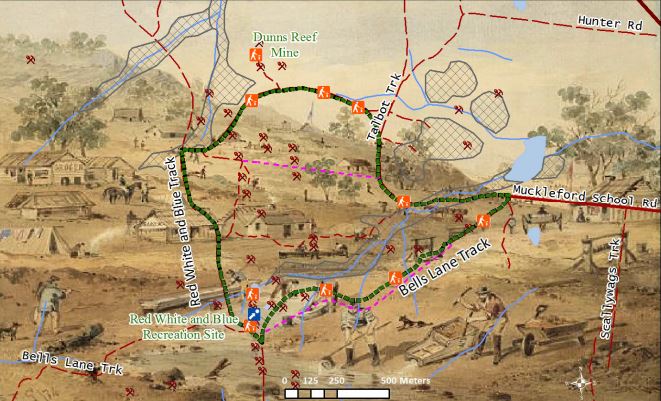
The red white and blue walking track is an easy five kilometre walk through the Box-Ironbark forest to Dunn's Reef. It starts at the Historic Red White and Blue Mine Site.
Along the walk you will find interpretive information boards telling you interesting stories of Muckleford State Forest's natural and cultural landscape that will inspire you to look at your surrounds through different eyes.
DUNN'S REEF
Dunn's Reef was a prominent exposed quartz reef before mining took place. It was mined on four main occasions.
Reef opened - late 1850s
Concord Association - early 1860s
Dunn's Reef Co - c 1875-1882
Concord Co - 1914-1915.
By 1859 the shaft at Dunn's Reef was 320 ft deep. In 1876 the Dunn's Reef Company had a cross-cut at the 200 foot level. A reef in the crosscut showed payable gold.
The track leads to the open cut. Other features are the remains of a loading ramp, a rectangular levelled area with a spread of rubble of hand-made bricks at base of the loading ramp, a large water dam in the gully, and two sludge ponds upstream from darn. The remnants of a tailings dump can be seen below the darn.
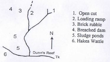
A Hakea Wattle (Acacia hakeaides) is growing beside Dunn's Reef Track. It is the only known wild specimen in the district.
IRONBARK FOREST
Ironbarks are the large dominant eucalypts with rugged, dark-coloured bark. Other eucalypts growing in the area include Red Box and Grey Box. When the original trees were cut down, suckers grew from the base. These have now grown, and many of the trees now have several trunks.
Tussock Grass and many kinds of shrubs are present.
Ironbarks flower in winter. If the flowering is profuse, the forest supports large populations of nectar-feeding birds.
RED, WHITE AND BLUE MINE (GOLDEN AGE MINE)
The mine is on the Red White and Blue quartz reef. Mining continued on and off for many years. In 1871 a shaft was sunk to the water level at 170 feet. Between 1909 and 1915 a total of 2369 ounce of gold was recovered from 4,452 ton of ore. The lease was acquired in 1957 by the Golden Age Gold N/L. The mine was re-opened in 1958, using plant purchased front Bendigo mines. The poppet head was originally at the Deborah United Mine in Bendigo.
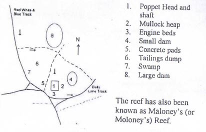
South of the poppet head are several concrete machinery bases, including a 2.5 m square winder bed (to raise and lower the cage in the shaft), and an engine bed.
A drain carried water from the shaft to the smaller dam.
Quartz containing a small amount of gold was mined, and crushed before being treated to extract the gold. The treated sand (called battery sand) was placed in the tailings dump. Most of the battery sand has now been removed for packing sand. It has high levels of naturally occurring arsenic.
Red White and Blue Mine Site - What can I see here?
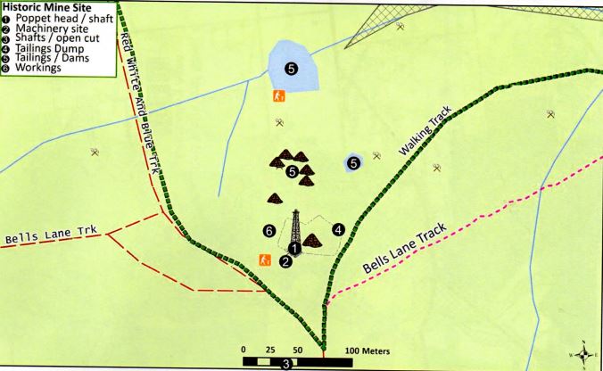
Historic Mine site
(1) Intact, standing poppet head: tubular steel legs, winding wheels, remains of timberwork.
3-compartment shaft with its intact concrete baling pond
(2) To the south of the poppet head:
Machinery site: remains of square concrete winder bed
A concrete winding engine bed
Several concrete air-receiver pads
A boiler setting depression, an iron damper plate is visible on the south east corner of the engine site. The boiler setting has a short flue depression running from its rear end to the remains of a square brick chimney stack base.
(3) Further South:
A partially buried small narrow open cut associated with two filled (subsided) shafts. Both shafts still have sections of their wooden collars exposed.
(4) East of the shaft:
Small intact mullock heap
Six short dumping lines from an earlier mining phase.
(5) North of the poppet head:
Two large dams
A drain leading from the shaft's baling tank to the closest dam.
Extensive dumps of treated tailings.
A band of of shallow alluvial sinkings runs south down the gully below the dams and continue as far as the Dunns Reef Track.
(6) West of the poppet head:
Several sections of concrete flooring and some post stumps
Small exposed section of a stone footing (possibly a battery site).
The poppet head/concrete engine beds etc belonged to the Golden Age Gold NL (1957 to c. 1960), while the tailings were generated by Maloney's Red White and Blue (1909 to 1915 ).
SHALLOW WORKINGS
A tributary of Back Creek extends from the large dam (at the start of the walk) to the Red White and Blue Mine. The gully has been extensively mined, and the scars of the shallow alluvial mining are still clear.
The debris associated with these workings is from the 20th century, so some of the mining works were probably carried out by unemployed people during the depression years.
At lower elevations Grey Box and Yellow Gum are the main tree species. Yellow Box may also be present. The most common shrubs are Coffee Bush, Golden Wattle and Gold-dust Wattle. There may be few other shrubs. Red Box, Mealy Bundy and Red Ironbark grow on more elevated sites.
Activities to Enjoy in the State Forest:
There are many activities you can enjoy in the forest, some of which include:
- Get active! Walk along one of the many tracks around the forest, ride your horse or bike along the bush roads and appreciate the beauty of the forest. Be sure to stay on formed roads when riding.
- Find a nice spot to relax, camp or have a picnic, remember to look after the forest by taking your
rubbish home with you.
- Take your dog for a walk. Making sure your dog is under control at all times and does not disturb other visitors or harm wildlife.
- Try your luck fossicking or prospecting. All prospectors require a Miner's Right. Remember to re-fill any holes you dig.
- Enjoy a car or motorbike tour of the forest, exploring the extensive road network. Make sure you are licensed and registered and always stay on formed roads.
- Explore and search the forest for clues that give us evidence from the past - remember to leave everything as you found it.
Getting Here:
The Muckleford State Forest is approximately 130 km north west of Melbourne via the Calder Highway and 50 km south of Bendigo. Located just 15 km south west of Castlemaine, the Muckleford State Forest is a great spot to relax, participate in a recreational pursuit or explore the history of the
area.
From Castlemaine, take the Maldon Road. Turn south onto Muckleford Road, then right onto the Muckleford School Road. Follow into Muckleford State Forest. The walk starts at the intersection of Bells Lane Track, Talbots Track and Muckleford School Road.
Access for Dogs:
Dogs are permitted on leash.
Location
Cnr Bells Lane Track and Red White and Blue Track, Muckleford 3451 View Map
Web Links
→ Red White and Blue Recreation Site - Muckleford State Forest (PDF)


")