Harcourt North - La Larr Ba Gauwa Mountain Bike Park


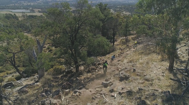
La Larr Ba Gauwa Park is a world class mountain bike park near Harcourt in Central Victoria which includes 34 kilometres of diverse mountain bike trails that take advantage of the area's stunning views and unique rock features.
There are 11 trails (1 green, 7 blue and 3 black level) that cater to riders of all abilities from beginner to advanced. La Larr Ba Gauwa Park has everything from a leisurely beginners' loop to long, flowy cross-country rides and technically challenging trails featuring chutes, berms, drops, jumps and rock gardens.
The trails are:
1. Wanyarra 2.3km. Wanyarra is a relatively smooth ride, suitable for all riders, as an easy introduction to the stones and mountain of the La Larr Ba Gauwa landscape. It's a great trail for beginners and a genuine destination in its own right, especially for family riders. The scenic ride meanders around Picnic Gully Creek, through open woodland, large pines and The Oak Forest. Its gentle slopes and smooth trails serve as the gateway into all of the other Northern Trails. (Green beginner level)
2. Girra 2.4km. It zig-zags the mountain-side, up and over granite floors, to set up a more direct ride home. Eager thrill-seekers also know it as the gateway to the Northern Hub: from there, Wilkerr, Murnong and the wicked Werpil await... On the way back down to Wanyarra, Girra gives you a choice: left, where a smooth downhill looks the safest way, or right for the trail's true jumps. (Blue intermediate level)
3. Wilkerr 3.5km. It begins with a long flowy descent. It might feel easy at first, but you'll soon encounter some well-placed technical features. Much of the natural rocky outcropping is integrated seamlessly along the trail. If you look up, you might also see the imposing 'target rock' to the right of the track: local marksmen used to practice their accuracy there as they readied for war. At the northern end of the Park, Wilkerr gets pretty close to the creek, before curling back to the south. There's an opportunity to hop across to Murnong (#4), or build up some pace before a steady switchback climb to bring you back to the Northern Hub. (Blue intermediate level)
4. Murnong 3.2km. Flowy berms and slab rock gardens are a feature of the first section of this trail as you roll off the saddle near the northern knoll. The main section of the ride takes you through native woodland interspersed with a small sugar gum plantation. A steady, weaving climb with great views of the northern knoll takes you back to the Northern Trail Hub. (Blue intermediate level)
5. Werpil 1.3km. Werpil is a very difficult 1.3km 'black diamond' circuit. The initial climb is steep and technical. It runs up a narrow, hand-crafted track to the northern knoll. There, you'll discover some of the region's finest views. Then, the challenging but playful descent features extensive granite rock-gardens and chutes that make the most of the natural terrain. Please keep to the trail alignment: it'll improve your chances of avoiding the moss beds on the granite slabs. (Black very difficult level)
6. Barramul 1.9km. Barramul is probably the gentlest of La Larr Ba Gauwa's intermediate trails. Once you've mastered the green of Wanyarra, consider Barramul your next challenge. Barramul starts with a gradual, undulating climb through rocky outcrops. On your way, you'll look down and across large pines and oaks in the valley below. Two huge river red gums mark the halfway point. They offer a peaceful place to take catch your breath. This is also your only access through to the more difficult trail, Milipa (#9). The fast and flowy descent features berms, rollers and some of the rock features for which La Larr Ba Gauwa is famous. (Blue intermediate level)
7. Gart-Gart 5.0km. The longest trail in the park starts with a climb that takes you to the top of the southern knoll. Your effort is well rewarded by outstanding views across the Harcourt Valley and toward the Pyrenees. There's a chance to veer southwards along a short trail that connects with the very challenging trail, Mir (#8). If you continue on Gart Gart, however, you'll encounter meticulously hand-paved climbs, a variety of terrain and astounding views. About half way through the Gart Gart, you'll arrive at the Eastern Hub, with connections to a couple of other trails. Finally, a long and playful descent takes you back to the trailhead. (Blue intermediate level)
8. Mir 3.6km. Mir launches with a gruelling ascent that includes many technical features. It is the longest of the Black Diamond challenges at La Larr Ba Gauwa, and well worth it for anyone who has the ability. At the zenith, you get an eye-full of awesome with what some regard as the best lookout in the park. The winding, technical descent features a line down a huge granite slab, a drop section and a meticulously paved, steep granite chute.It really can be quite challenging at times, so at many of the technical features you'll see alternative lines to get around them, if necessary. (Black very difficult level)
9. Milipa 4.6km. Incorporates multiple climbs and descents with natural and hand crafted features including rock slabs, large berms and tight switch backs. (Blue intermediate level)
10. Gurri 3.6km. A flowy cross-country trail that starts with a short climb then a winding descent with lovely views. Another gentle climb then a short descent returns riders to the Southern Trail Hub. (Blue intermediate level)
11. Milakuk 2.4km. Milakuk is the highest rising trail on the mountain. While the climbs are numerous, the effort is very well rewarded: from it's thunderous heights, the views are amazing. Its technical climbs are followed by fast and challenging descents. Features include drops, catcher berms and rock-gardens. At the bottom of the descents, the trail crosses gullies and creeks. Along the way, you'll ride extensive hand-crafted and natural stone sections. (Black very difficult level)
Make sure you take plenty of water with you before you leave Harcourt as there is no potable water available at La Larr Ba Gauwa Park.
Trail Maps:
La Larr Ba Gauwa Trail Map (Forests & Reserves Victoria)
La Larr Ba Gauwa Trail Map (Trailforks)
You can also download the More to Explore App for comprehensive information and interactive maps for La Larr Ba Gauwa Park.
Location:
La Larr Ba Gauwa Park is two kilometres east of Harcourt and adjacent to the Mount Alexander Regional Park. It is 130 kilometres north of Melbourne.
Car parking for La Larr Ba Gauwa Park is in the Harcourt township. Park your car on High Street, opposite the CFA station, then ride to the Park via the off-road path that runs alongside Market Street and Picnic Gully Road. This path will take you straight to the Trailhead. There is no parking for bike riders at La Larr Ba Gauwa Park.
Location
Picnic Gully Road, Harcourt North 3453 View Map
Web Links
→ lalarrbagauwa.harcourt.vic.au
→ La Larr Ba Gauwa Park on Facebook
→ Trail Map
→ Mountain Bike (MTB) Parks in Melbourne and Victoria


")