Koroit Heritage Trail


Koroit Heritage Trail is a self-guided journey through one of Australia's most complete early Irish settlements. It explores 31 historic places around Koroit, with nearby Tower Hill Wildlife Reserve included as an additional destination on the brochure map.
Koroit stands on the northern rim of the Tower Hill volcanic crater. Its name derives from the Koroitch Gundidj people, who occupied the area for thousands of years. The rich volcanic soil subsequently attracted Irish immigrant farmers during the 1840s and 1850s, many of whom established small grain and potato farms.
The town developed with the culture and character of its Irish settlers. This heritage remains evident in Koroit's churches, cottages, public buildings, hotels and streetscapes.
The trail begins at Tower Hill Common School in Victoria Park. The route continues through High Street, Mill Street, McVicar Street, Commercial Road, Station Street, Garden Street, Anzac Avenue, Anne Street and Horne Street before returning to the Common School.
The numbered sites should be followed using the downloadable heritage trail map. Some buildings are private residences and should only be viewed from the street.
Distance:
Approximately 3 km for the town trail.
Start/Finish: Tower Hill Common School, Victoria Park, High Street.
Sites: 31 places around Koroit, plus Tower Hill Wildlife Reserve as site 32.
Mode: Walking or cycling. Tower Hill Wildlife Reserve requires a separate drive.
Koroit Heritage Trail Map
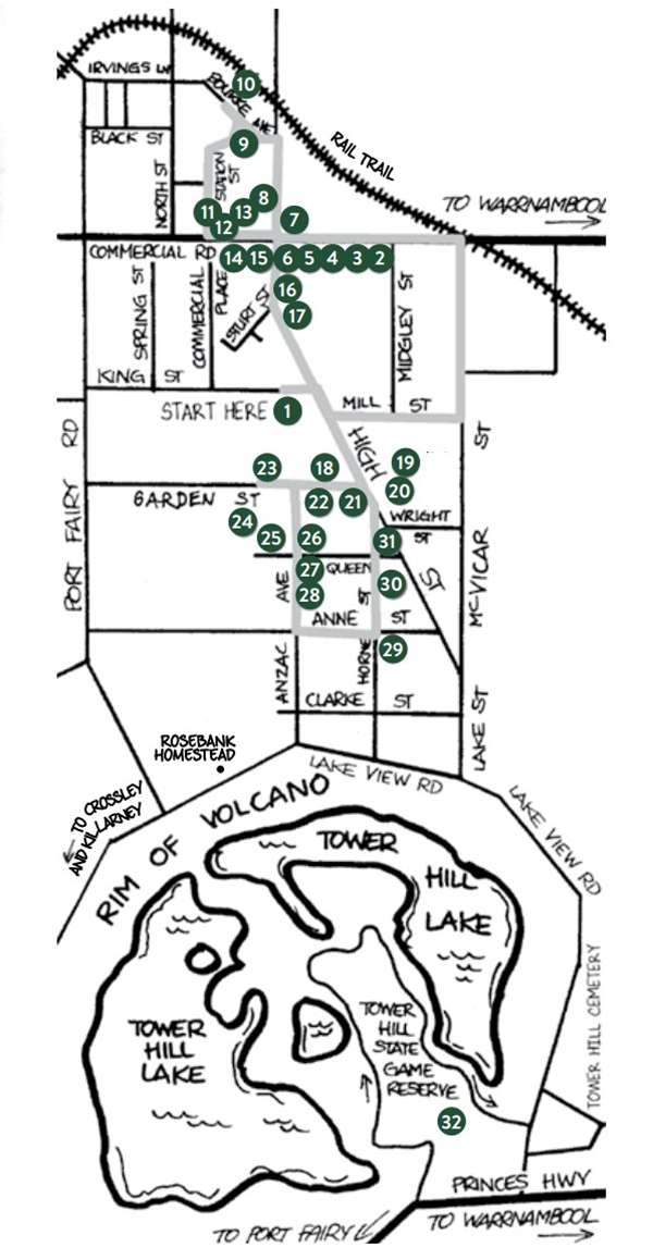
Koroit Heritage Trail Sites:
1. Tower Hill Common School
The Koroit Heritage Trail commences at the Tower Hill Common School in Victoria Park, High Street.
The former Tower Hill Lake National School was the first public building in Koroit, opened in 1857 and is the last substantially intact authentic example of the National School era.
Registered by Heritage Victoria, restored by the Koroit & District Historical Society and used as their headquarters.
Address: 79 High Street, Koroit
Directions: Leave Victoria Park, turn right into High Street, then left into Mill Street, past Moyne Health Services Spring Park Campus, formerly Spring Park Nursing Home, formerly Koroit and District Memorial Health Services, opened in 1955.
Turn left into McVicar Street, noting the view of the Murray Goulburn factory to the left.
Turn left into Mailors Flat/Koroit Road and stop opposite the Murray Goulburn Factory.
2. Koroit Butter Factory
The Koroit Butter Factory first opened in 1889. Now operating as Murray Goulburn Co-operative Company Ltd., the largest dairy processing plant in Australia.
Address: 23 Commercial Road, Koroit
3. State School No. 618
State School No. 618 opened in 1878, residence built c.1890. Sir John Eccles (1903 - 1997), a former student, went on to become a Nobel Prize winner and Australian of the Year (1963).
Address: 91 Commercial Road, Koroit
4. Former Court House
Former Court House opened in 1872 and functional until 1976. Classified by the National Trust.
Address: 93 Commercial Road, Koroit
5. Former Police Residence
Erected c1885 as police residence, originally had a detached building on the east side as the Police Station. New Police Station building officially opened in July 2007.
Address: 95 Commercial Road, Koroit
6. Koroit Post Office
Original Post Office opened in 1858, current building completed in 1872. Home of author, Henry Handel Richardson from 1878 to 1890. Classified by the National Trust.
Address: 99 Commercial Road, Koroit
7. The Old Courthouse Inn
The Old Courthouse Inn built in 1901 as an hotel, continuing the licence of the Dunfermline Inn built on adjacent site and first licensed in 1857.
Address: 100 Commercial Road, Koroit
Direction: Turn right into High Street.
8. Abercorn
Abercorn, built as a residence with adjacent shop front, one of the first general stores in the town about 1875.
Address: 123 Commercial Road, Koroit
Direction: Turn left into Bourke Avenue.
9. Former Station Master's Residence Site
Corner Station Street and Bourke Avenue, site of former Station Master's residence. Access point also for Rail Trail.
Address: Cnr Station Street and Bourke Avenue, Koroit
10. Koroit Railway Station
Railway Station operated from 1889 to 1977. Original building was timber, existing brick station building completed in 1907 and currently undergoing restoration.
Address: Bourke Avenue, Koroit
Directions: Turn left and move along Station Street.
Note the varying architecture and the Norfolk Island Pines, planted in August 1906 and listed on the National Trust's Register of Significant Trees.
Turn left into Commercial Road. The commercial and administrative precinct is classified by the National Trust.
Note the shop fronts, kerbline verandahs and imposing public buildings.
11. Corner Store
Corner Store, built 1883, operated by the Daly family since 1918.
Address: 150 Commercial Road, Koroit
12. Barr's General Store
Large double fronted shop built c.1906. Operated for many years as Barr's General Store.
Address: 132-134 Commercial Road, Koroit
13. Former National Australia Bank
Former National Australia Bank opened in 1868, as a single-storey building, second storey and façade added in the late 1880s. Ceased trading in 2002. Now a private residence.
Address: 110-112 Commercial Road, Koroit
14. Former Colonial Bank of Australasia
Former bank building, built in 1876 as Colonial Bank of Australasia. The State Savings Bank of Victoria, established in 1842 to safeguard the savings of early colonists, opened a Koroit branch in September 1920. Later became the Commonwealth Bank of Australia. Ceased trading in 1996. Now a private residence.
Address: 109-111 Commercial Road, Koroit
15. Koroit Hotel
Koroit Hotel built in 1861 as a simple, double-storeyed bluestone building. Art Nouveau façade added in the early 1900s.
Address: 101 Commercial Road, Koroit
Direction: Turn right into High Street.
16. Former Fire Station Site
Site of the former Fire Station, built in 1900, then used as the Guide Hall. Building demolished in September 2006, after an arson attack earlier that year.
Address: 94 High Street, Koroit
17. Former Koroit Borough Chambers
Former Koroit Borough Chambers, north wing built in 1878, south wing in 1970. Borough of Koroit was constituted in 1870, amalgamated with Shire of Warrnambool in 1985, became part of Moyne Shire in 1994. Now houses the Library.
Address: 102 High Street, Koroit
18. Koroit Botanic Gardens
Botanic Gardens designed by William Guilfoyle in 1869, laid out by Robert Whitworth, with trees selected by Baron von Mueller. Contains several trees classified by the National Trust. Added to the Victorian Heritage Register in February 2007.
Address: Cnr High and Garden streets, Koroit
19. Old Hillcrest
Old Hillcrest, a substantial late Victorian residence built in 1910 by Richard Skilbeck, one of Koroit's earliest pioneers.
Address: 60 High Street, Koroit
20. The Pines
Early cottage formerly known as "The Pines", the first home of Richard Skilbeck, built in 1860. Authenticity was eroded by later renovation, although part of the original roof is thought to still exist under the iron then later, tiled roof.
Address: 44 High Street, Koroit
21. Former Methodist Church
Former Methodist Church, original timber building opened in 1859, existing building opened in 1868, closed in 1970s. Now serves as the Scout Hall.
Address: High Street, near Garden Street, Koroit
Direction: Return right into Garden Street.
22. Scots Presbyterian Church
Scots Presbyterian Church opened in 1861, adjacent Manse built 1863/64.
Address: 11 Garden Street, Koroit
23. Historic Horse Trough
Historic horse trough, one of many placed in country areas by Annis and George Bills in the 19th Century.
Address: Garden Street, west of Anzac Avenue, Koroit
24. Early Settlers Cottage
Early settlers cottage. Probably built in 1889/90.
Address: 63 Garden Street, Koroit
Directions: Turn to Anzac Avenue and turn right.
25. Former Convent of the Good Samaritan Sisters
Former Convent of the Good Samaritan Sisters, opened in 1907. Operated as a hostel and school camp from 1973 until 2001. Now privately owned.
Address: 55 Anzac Avenue, Koroit
26. St Patrick's School
St. Patrick's School, first established in 1890, oldest existing building dates from 1921.
Address: 20 Queen Street, Koroit
27. Catholic Church of the Infant Jesus
Catholic Church of the Infant Jesus, designed by William Wardell who was also responsible for St. Patrick's Cathedral in Melbourne. Original section opened in 1870, later extensions added in 1915 - 16.
Address: 18 Queen Street, Koroit
28. Catholic Church Presbytery
Catholic Church Presbytery, built in the late 1880s.
The church precinct is classified by the National Trust.
Address: 46 Anzac Avenue, Koroit
Direction: Turn left into Anne Street.
29. William Crowe Residence
A gracious example of late Victorian architecture built as late as 1918 by William Crowe, civic leader for over forty years. Note shamrock on stonework above front left window.
Address: 21 Anne Street, Koroit
Direction: Turn left into Horne Street.
30. St Paul's Anglican Church
St. Paul's Anglican Church built in 1870. Note fine view of Catholic Church buildings across playing fields opposite.
Address: Cnr Horne and Queen streets, Koroit
31. Edwardian Weatherboard Home
Weatherboard home, built in 1900, a fine example of Edwardian architecture.
Address: Cnr High and Wright streets, Koroit
Direction: Turn left into High Street and return to the Common School.
This marks the end of the formal heritage trail.
Trail created by the Koroit & District Historical Society
Location
Victoria Park, High Street, Koroit 3282 View Map
Web Links
→ Koroit Heritage Trail Map (PDF)


