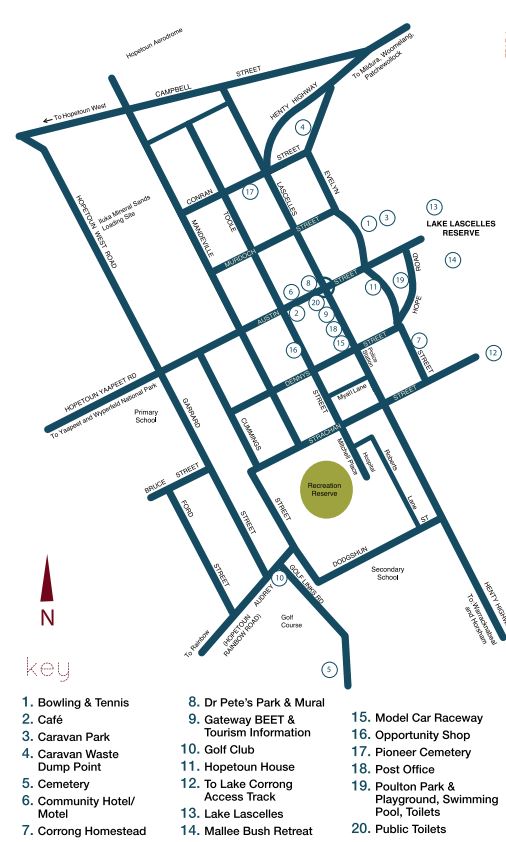
Hopetoun Walk & Drive Town Discovery Tours

There are a number of walks around Hopetoun ranging from 10 minutes to 1.5 hours. The Fountain which is the starting point for all the town walks is at the intersection of Lascelles and Austin Streets.
Walk 1 - Time: Approx 10 mins
Shopping area includes Bow Bakery for fresh baked bread, pies, pastries, cakes etc. Gateway BEET (Shire offices) stained glass window made and designed by local arts and crafts community, Post Office, Homeden Guest House (privately owned, now private residence). Feet First Footwear, Hopetoun Newsagency, Hopetoun Community Hotel, Club Hotel (closed-currently pop up shop from time to time) Memorial Hall, Public toilets, Butchers, Cafe and Bon Bon Cafe, Pharmacy, IGA, Kaye's Kollection and Commonwealth Bank.
Walk 2 - Time: Approx 1.5 hours
Walk east down Austin Street towards Lake Lascelles, where you will pass the Hopetoun Bowling Club, Swimming Pool, RSL Hall, Tennis Courts and Caravan Park. Lake Lascelles is a man made lake previously filled by a channel system which is maintained by a Lake Committee. Gas BBQ's. Playground and amenities. It is possible to walk around the lake, which is abound with bird life, also fish. Heading back towards town, turn up Hope Road to the Playground, crossing over the road to Corrong Homestead Station built in 1846 with pine logs, fitted together drop log fashion hand adzed to shape. Lake Corrong was the original water supply being fed by the Yarriambiack Creek which is mainly dry due to the control of the Wimmera River System by man. It now only fills when there is an above average wet year. Also on this site "McGinnis Park" is Hopetoun's first Pump Engine (steam) bought out from England for an experimental orchard. The Lochs west of Hopetoun Mr Parkes managed the orchard for Mr Lascelles. Down at this end of Evelyn Street is the present town water supply reservoir. On the way back on the corner of Evelyn and Dennys Streets, built of red brick this house was built for EH Lascelles stock Manager in 1913. On the opposite corner No 83 built in the 1890's from limestone and mortar with brick corners.
On past our 1980's style home to Hopetoun House No 77 classified by the National Trust built for Mr EH Lascelles his wife and four children. Built from limestone quarried north of the town in 1891 it has both coloured and stained glass and features sea weed use as insulation bought from Portland. A very large room known as the ballroom is also built in the house, half way below ground level. Continuing on over Austin street, returning past the bowling club, one of Victoria's first clubs to be able to bowl at night with fights; another limestone house 61 Evelyn Street now painted white also the Hopetoun joint Scout Guide Hall. Opposite at number 57 built in 1904 also of limestone with brick corners. Victorian style with wrought iron lace and inside cornice ceilings. On the corner of Evelyn and Murdoch Streets is another cottage built of limestone also built in 1904 by the same builder of no 57 Evelyn street, Mr. Poulton. Tum up Murdoch Street to the Highway and back south to the fountain.
**These homes mentioned are private and not for public viewing**
Walk 3 - Time: 30 minutes. Starting Point: The Fountain
Walking north up Lascelles Street past the Uniting Church on the left, the old power house station and the water tower, is the Church of England on the right. Next to the church is one of Hopetoun's first built homes, 'Roseneath", featuring bullnose verandah, tiles and made of limestone, built for the man who mapped out Hopetoun, Mr Murdoch. Beside Roseneath is a house which was built as a Station Hut built in the 1890's made of wattle and dub vertical slab.
Opposite was possibly Hopetoun's first church, wooden, built in 1894. Over the lane is The limestone: Baptist Church built in 1922. On to the comer of Conran Street, is a concrete home, used in both walls and ceiling. The feature Is double concrete walls hollow and 9" between. Seaweed was used as insulation, coming from Portland. Opposite Is the Catholic Church and Convent School. From the top of this hill you can see the all weather aerodrome with radio activated night light facilities, Shire Depot and also the wheat fields. Continuing on down the highway to the bottom of the hill is a nice shady picnic area, with Information board depicting floods of 2011. Wood BBQ and popular stopping place for travellers for a 'cuppa'.
By turning left into Conran Street you can see the sign "Pioneer Cemetery" where some of the first pioneers were buried. Continue on to Toole Street, looking west you can see previous Toddway Lodge/ now Conways Gypsum and view in distance of Kalari transport station.
The Masonic Hall built in 1924 A.D: at No 17 is another of Hopetoun's first homes built of limestone In 1887 by men coming up from Goyura, it has a cellar in it, to be used to keep things cool; Lutheran Sunday School classes were also held in it. Continuing to walk south. crossing over Murdoch Street, named after the Architect, who laid out the Street Plans, is where the old Ice Works were, then the old Blacksmith's shop, back up to Austin Street and to the Fountain.
Walk 4 - Approx. 45 minutes. Starting Point: The Fountain
Walking south down the main street, Lascelles Street, past the (previous Shire Offices) now Gateway BEET, Post Office, Baker's shop and the previous "Homeden Guest House" (now privately owned) on down to the previous Hopetoun Bush Nursing Hospital site (vacant block, some buildings still exist and are used as nurses sleeping quarters) onwards to Dodgshun street (named after the late Hon. Keith Dodgshun, Deputy Premier of Victoria, and Chief Secretary), past the Hopetoun P-12 College and grounds, turn right towards new hospital part of Rural Northwest Health and Aged Care facilities towards Mitchell Street past Doctors Surgery and independent living houses as well as Community Garden est. 2015. On the left is the Recreation Ground with the old racecourse Grand Stand which had been shifted in from the defunct racecourse. past the Lutheran Church, Senior Citizens' Clubrooms, Hopetoun Op Shop which previously housed the Magistrates Court and our local paper "Hopetoun Courier" office (now located Inside Gateway BEET) to Austin Street and back up to the fountain.
Walk 5 - Time: Approx. 45 minutes. Starting Point: The Fountain
Walking west down towards the Railway Line, past the Memorial Hall, local supermarket and shops. Victoria's first Co-op Community Hotel, the old Billiard room, Hopetoun Mens Shed to the corner of Austin and Mandeville Street. Notice the bull nose verandahs, parquetry tiles and the home with the original hedge. Over the railway line on the right are the barley silos, Hopetoun Bulk Storage and Kalari transport. The Hopetoun Neighbourhood House which also houses the historical society, opened by appointment.
The large Grain Shed and Wheat Silos, 1 million bushells capacity, built in 1939 Up Bruce Street to the previous Primary School, back down to Garrard Street, heading south of Hopetoun's 18 hole golf course, one of the first built outside the Metropolitan area; back over the railway line to where the Hopetoun railway station used to be (the first locomotive came to Hopetoun on December 11, 1893). Walking past the Hopetoun Recreational Reserve, home to Southern Mallee Giants, Hopetoun Cricket Club and Hopetoun A & P Society. And housing historical Hopetoun Grand Stand. Turn up Dennys Street, past the Kindergarten and Health Centre and Child Care Centre (this area once contained a 10-stand community shearing shed.) Back up the hill to Lascelles Street and back to the fountain.
A Quiet Drive Around Hopetoun
- Drinking Fountain. Memorial to Eli Lascelles Father of the Mallee erected 1929
- Memorial Hall. Built 1923 to honour Hopetoun soldiers who went to World War 1
- Hopetoun Community Hotel-first co-op hotel in Victoria
- Fountain on site of Hopetouns first water supply-a large tank, laid in 1891
- Left along Lascelles street. Limestone shops on right-built before 1905
- Church of England built of limestone 1907
- Baptist Church-built 1922-the last limestone building to be erected (private dwelling)
- Site of Limestone house -Roseneath" built early 1890's for George Murdoch, surveyor and town planner-demolished mid nineties.
- Pug house-A station employee lived here before 1890
- Pause for view of aerodrome-panorama view of the Mallee-turn right into Conran Street-right again into Evelyn street
- Limestone house on the corner of Murdoch and Evelyn Streets.
- Scout/Guide, Cubs/Brownie Hall.
- Bowling Greens. Turn left to Lake Lascelles passing Tennis Courts and Caravan Park.
- Return to Evelyn Street past swimming pool - playground. Hopetoun House 1891.
- Limestone house on corner of Dennys Street.
- McGinnis Park - Lake Corrong Station Homestead - Pioneers' Memorial - Historic Pump. Tum right into Strachan Street past Bush Nursing Hospital now a vacant block. Tum lett into Mitchell Street past Recreation Ground and community garden, Hospital and aged care facilities. Return to Strachan Street, turn right back to Lascelles and right again towards Dodgshun street, turn right past the Secondary College, right then left over Railway line - past Golf Links - right into Garrard Street past Silos - Primary School - Education Centre and Historical Museum.
- Right into Austin Street, left into Mandeville Street, house on comer with bull-nose verandah past what was previously known as Toddway Trotting Stud where two Oak's winners were bred and trained - now Conways Gypsum; right into Conran Street, right again into Toole Street, past Masonic Hall and Senior Citizens rooms - left into Dennys Street, left again into Lascelles Street - end at Gateway BEET.
Map of Hopetoun
Location
70 Lascelles Street, Hopetoun 3396 View Map
Web Links
→ Hopetoun Walk & Drive Town Discovery Tours Brochure (PDF)


")