Healesville Historic Walk

Take a walk through yesteryear... This 3.3km return historic walk is a collaboration between the Rotary Club of Healesville, Healesville & District Historical Society and Healesville 150th Committee on the occasion of Healesville's 150th Anniversary in November 2014.
150 Years Later...
Healewille began as a 'stopping place' for prospective miners en route to the goldfields of Matlock, Jerico and Woods Point. Parliament had made 30,000 pounds available to construct a 'road' through the mountains, work beginning in 1863.
The new route avoided the flat, flood-prone areas between the former New Chum settlement and the Watts River. It was on this higher ground that an area was surveyed in 1864, land sales taking place in 1865 and a new hamlet established. It was to be named Healesville to commemorate the recently deceased former Premier of Victoria.
The main street (Nicholson Street) was a wide tree-less thoroughfare, decidedly bleak-looking, with deep gutters on both sides, and poorly-formed footpaths. The settlement was a crude, 'backblocks' place, dusty in summer and muddy in winter. The buildings were, in general, primitive one-storey paling structures with verandas extended over the footpaths, with single roofs, slab floors and hessian on the walls. However, by 1866 over thirty homes and businesses had been developed. They included six hotels, a saddler, a blacksmith and several carriers.
The focal point of the town became William Hall's blacksmith shop. It became "the resort of every man who owned a horse". The horses went to Hall's and their drivers to the Glasgow Arms (as the Yorkshire Arms had become). However, one traveller in 1872 was very unimpressed asserting that Healesville was not a lively place and "produces a rather depressing effect upon the wayfarer". He described the town as looking as if it had "missed its way, wandered a long distance from the path of progress and coiled itself up in a corner to die".
Prophetically, he thought it may perhaps recover! Recover it did, but it was a long, slow struggle to discard its backblocks image. It was the arrival of the railway in 1889 that gave the impetus the town needed. New buildings, including three brick hotels, the foundation of many sporting and cultural societies and increasing numbers of visitors began to transform the character of the town during the 1890s.
Thereafter, for many decades tourism, the timber industry, the Maroondah Water Scheme and the Healesville Sanctuary were the lifeblood of Healesville.
The town experienced a 'downturn' in its fortunes during the 196os; and early 1970's and it was not until the revival of the wine industry during the next two or three decades, which brought with it a redevelopment of accommodation facilities, that the good times returned.
In the 21st century, although the importance of the timber industry has declined considerably, tourism is thriving, B&Bs abound, the Sanctuary is prospering and the resident population has grown. Healesville has much to celebrate in its 150th year!
The Coranderrk Story
In 1860 the Victorian Government established six stations for Aboriginal people, among them, one in the Acheron Valley. This soon proved to be an unsuitable location, hated by the Aboriginal people living there. John Green, General Inspector of Aborigines, was ordered by the Board for the Protection of Aborigines to find an alternative suitable site. After unsuccessful attempts to establish sites at Woori Yallock and Watts River, together with the Aboriginal people, for whom he was responsible, John Green chose 2300 acres on the banks of the Yarra River and Badger Creek.
They called it Coranderrk after the native Christmas bush growing in profusion in the area. Coranderrk was established in March 1863 for use on the 30th June 1863. The area was increased to 4850 acres on 24th July 1866.
In 1865, Coranderrk had a population of about 100, comprising 38 men, 23 women, 24 boys and 15 girls. One difficulty was that only about 20 were able-bodied men, expected to support everybody.
However, a viable settlement developed during the next decade, with the construction of permanent buildings, including a school, and the growing of crops, initially wheat and later hops.
One of John Green's objectives was to make the settlement self-supporting. Cattle for their own food and for sale were killed on the station, and log-felling became important also.
Following John Green's retirement from Coranderrk in 1876 there appears to have been a period of inefficient management until the appointment of Rev. Joseph Shaw in 1882. During his period in charge many improvements were made including the erection of a large brick homestead, which still exists.
The best known and most influential resident of Coranderrk was William Barak (circa 1823-1903). As with his cousin Simon Wonga, before him, Barak was an inspiring leader of his people, greatly respected by his fellow Aboriginal people and many in the non-Aboriginal population, including the Governor of Victoria, Sir Henry Loch. His fine character and quiet dignity made him an influence for good among his followers.
In 1948 the Coranderrk Lands Act allowed land to be sold for soldier settlement. In later years (the 1990s) some 275 acres were returned to the traditional Wurundjeri owners. In 1998 the Superintendent's House and 201 acres were sold by its private owner to the Indigenous Land Corporation with the expectation it would be returned to the Wurundjeri people of Healesville.
There is still a strong aboriginal presence in the district represented by the descendents of the last families of the Coranderrk Settlement, some of whom are responsible for the property that was formerly the site of the Army School of Health, and prior to that Summerleigh Guest House also Worawa College, a secondary school in Bank Lane established in 1986 by Hyllus Mans (nee Briggs), and now providing education for aboriginal girls.
Healesville Historic Walk
The Healesville Historic Walk is circular with easy walking access. Most are accessible for people with disabilities. Total Distance is 3.3 km return (90 min.). There are three sections:
- Railway Walk 0.5km (25 min. Nos 1 to 8)
- Nicholson Street Centre 1.5 km (45 min. Nos 9 to 15 & 21 to 27)
- East End 1.2 km (20 min. Nos 16 to 20)
Healesville Historic Walk Map
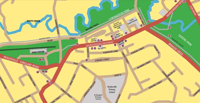
Healesville Historic Walk Points
1. Courthouse
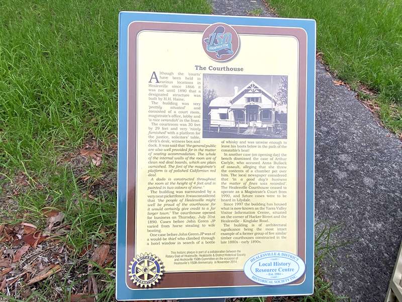
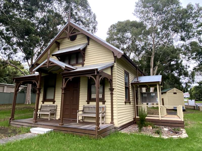
Although the 'courts' have been held in various locations in Healesville since 1866 it was not until 1890 that a designated structure was built by H.H. Haine.
The building was very 'prettily situated' and consisted of a court room, magistrate's office, lobby and 'a nice verandah' in the front.
The courtroom was 30 feet by 29 feet and very 'nicely furnished' with a platform for the justice, solicitors' table, clerk's desk, witness box and dock. It was said that 'the general public are also well provided for in the matter of seating accommodation. The whole of the internal walls of the room are of clean red deal boards, which are plain varnished. The font of the magistrate's platform is of polished Californian red deal.
A dado is constructed throughout the room at the height of 4 feet and is painted in two colours of stone.'
The building was surrounded by a very neat picket fence. It was considered that 'the people of Healesville might well be proud of the courthouse for it would certainly give credit to a far larger town.' The courthouse opened for business on Thursday, July 31st 1890. Cases before John Green JP varied from horse stealing to wife beating. One case before John Green JP was of a would-be thief who climbed through a hotel window in search of a bottle of whisky and was unwise enough to leave his boots below in the path of the constable's beat!
In another case (on opening day) the bench dismissed the case of Arthur Carlyle, who accused Anna Bullock of assault, alleging that she threw the contents of a chamber pot over him. The local newspaper considered that 'in a good day's business the matter of fines was recorded'. The Healesville Courthouse ceased to operate as a Magistrate's Court from 1990, and future cases were to be heard in Lilydale.
The building is of architectural significance being the most intact example of a former group of five similar timber courthouses constructed in the late 1880s - early 1890s.
2. Cell blocks
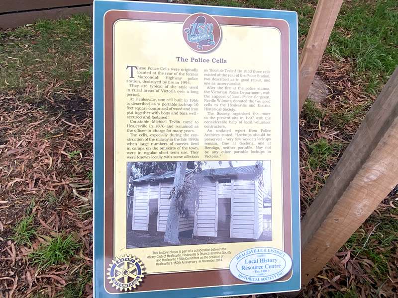
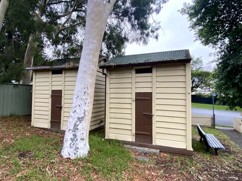
These Police Cells were originally located at the rear of the former Maroondah Highway police station, destroyed by fire in 1994.
They are typical of the style used in rural areas of Victoria over a long period.
At Healesville, one cell built in 1866 is described as 'a portable lock-up 10 feet square comprised of wood and iron put together with bolts and bars well-secured and fastened'.
Constable Michael Tevlin came to Healesville in 1876 and remained as the officer-in-charge for many years. The cells, especially during the construction of the railway in the late 1880s when large numbers of navvies lived in camps on the outskirts of the town, were in regular short term use. They were known locally with some affection as 'Hotel de Tevlin'! By 1930 three cells existed at the rear of the Police Station, two described as in good repair, and one as unserviceable.
After the fire at the police station, the Victorian Police Department, with the support of local Police Sergeant, Neville Wilmott, donated the two good cells to the Healesville and District Historical Society.
The Society organised the move to the present site in 1997 with the considerable help of local volunteer contractors.
An undated report from Police Archives stated, "Lockups should be preserved - very few wooden lockups remain. One at Geelong, one at Bendigo, neither portable. May not be any other portable lockups in Victoria."
3. The 'Palais'
4. Hospital
5. Terminus Hotel
6. Railway Station
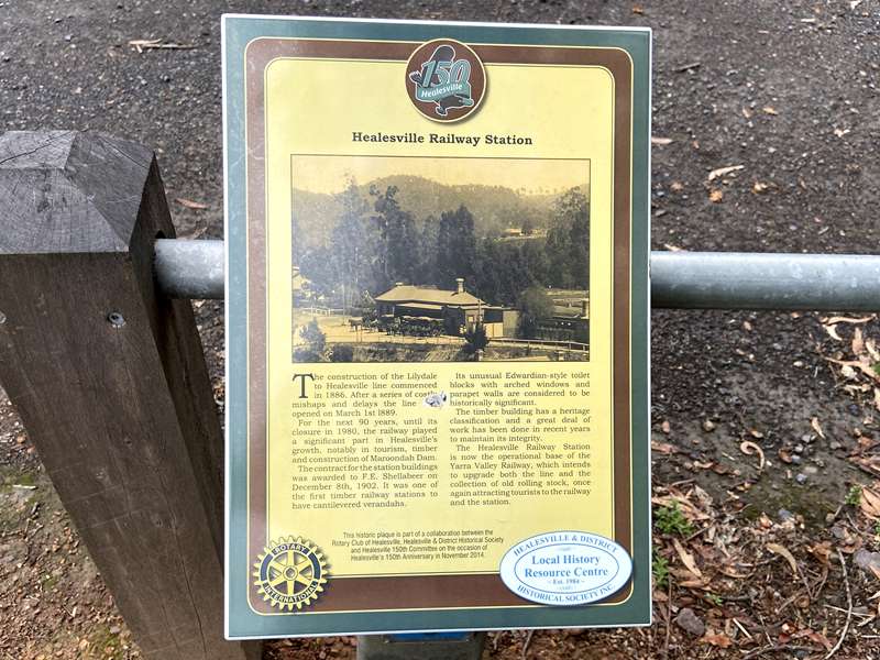
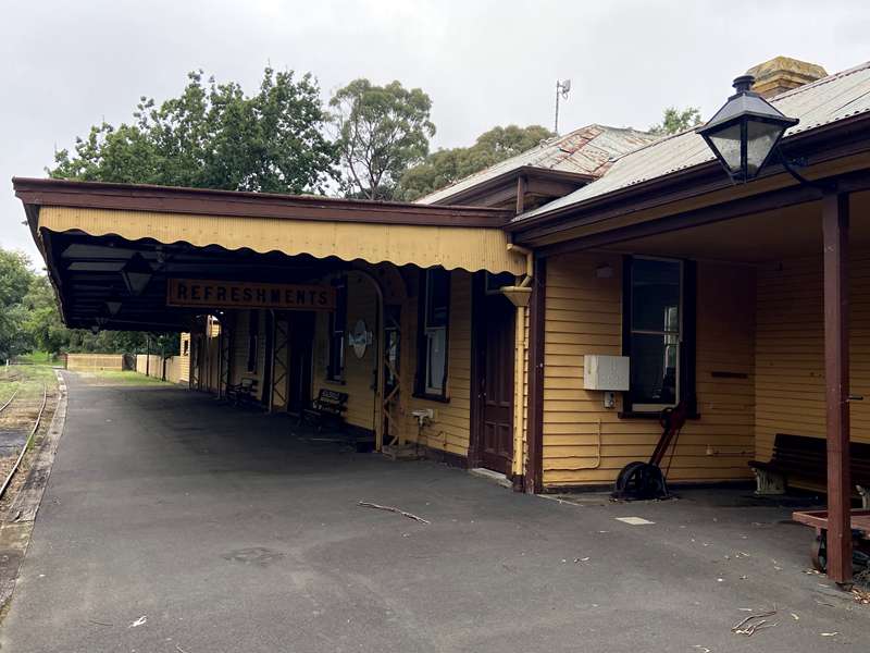
The construction of the Lilydale to Healesville line commenced in 1886. After a series of costly mishaps and delays the line opened on March 1st 1889.
For the next 90 years, until its closure in 1980, the railway played a significant part in Healesville's growth, notably in tourism, timber and construction of Maroondah Dam.
The contract for the station buildings was awarded to F.E. Shellabeer on December 8th, 1902. It was one of the first timber railway stations to have cantilevered verandahs.
Its unusual Edwardian-style toilet blocks with arched windows and parapet walls are considered to be historically significant. The timber building has a heritage classification and a great deal of work has been done in recent years to maintain its integrity.
The Healesville Railway Station is now the operational base of the Yarra Valley Railway, which intends to upgrade both the line and the collection of old rolling stock, once again attracting tourists to the railway and the station.
7. Railway Precinct
8. Rail - 'tourism gateway'
9. Rathrone House
10. Daly's Hall
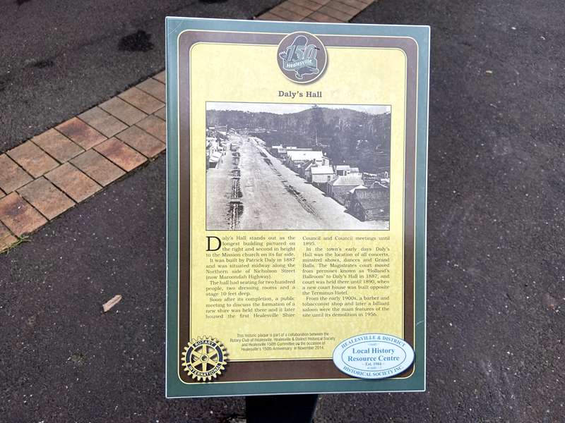
Daly's Hall stands out as the longest building pictured on the right and second in height to the Mission church on its far side. It was built by Patrick Daly in 1887 and was situated midway along the Northern side of Nicholson Street (now Maroondah Highway).
The hall had seating for two hundred people, two dressing rooms and a stage 10 feet deep. Soon after its completion, a public meeting to discuss the formation of a new shire was held there and it later housed the first Healesville Shire Council and Council meetings until 1895.
In the town's early days Daly's Hall was the location of all concerts, minstrel shows, dances and Grand Balls. The Magistrates court moved from premises known as 'Holland's Ballroom' to Daly's Hall in 1887, and court was held there until 1890, when a new court house was built opposite the Terminus Hotel.
From the early 1900s, a barber and tobacconist shop and later a billiard saloon were the main features of the site until its demolition in 1956.
11. Early churches
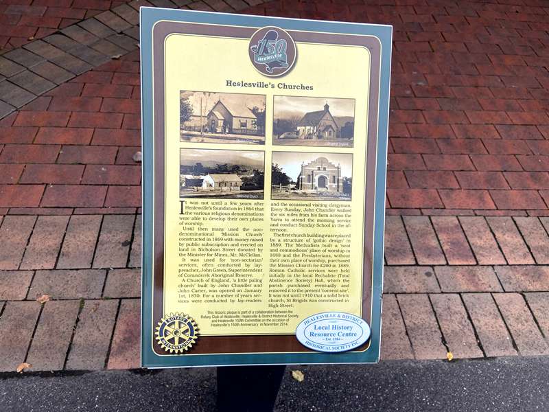
It was not until a few years after Healesville's foundation in 1864 that the various religious denominations were able to develop their own places of worship.
Until then many used the non-denominational 'Mission Church' constructed in 1869 with money raised by public subscription and erected on land in Nicholson Street donated by the Minister for Mines, Mr. McClellan.
It was used for 'non-sectarian' services, often conducted by lay-preacher, John Green, Superintendent of Coranderrk Aboriginal Reserve.
A Church of England, 'a little paling church' built by John Chandler and John Carter, was opened on January 1st, 1870. For a number of years services were conducted by lay-readers and the occasional visiting clergyman. Every Sunday, John Chandler walked the six miles from his farm across the Yarra to attend the morning service and conduct Sunday School in the afternoon.
The first church building was replaced by a structure of 'gothic design' in 1889. The Methodists built a 'neat and commodious' place of worship in 1888 and the Presbyterians, without their own place of worship, purchased the Mission Church for 200 pounds in 1889 Roman Catholic services were held initially in the local Rechabite (Total Abstinence Society) Hall, which the parish purchased eventually and removed it to the present 'convent site'. It was not until 1910 that a solid brick church, St Brigids was constructed in High Street.
12. Green & Coranderrk
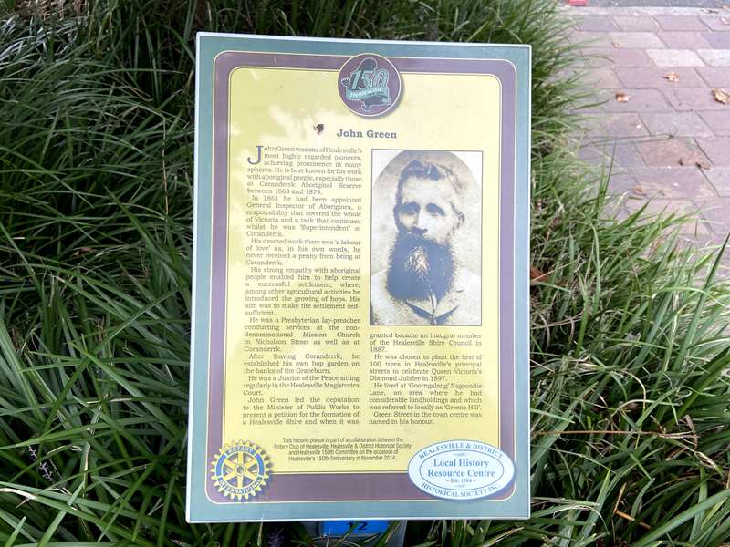
John Green was one of Healesville's most highly regarded pioneers, achieving prominence in many spheres. He is best known for his work with aboriginal people, especially those at Coranderrk Aboriginal Reserve between 1863 and 1874.
In 1861 he had been appointed General Inspector of Aborigines, a responsibility that covered the whole of Victoria and a task that continued whilst he was 'Superintendent' at Coranderrk. His devoted work there was 'a labour of love' as, in his own words, he never received a penny from being at Coranderrk.
His strong empathy with aboriginal people enabled him to help create a successful settlement, where, among other agricultural activities he introduced the growing of hops. His aim was to make the settlement self-sufficient.
He was a Presbyterian lay-preacher conducting services at the non-denominational Mission Church in Nicholson Street as well as at Coranderrk. After leaving Coranderrk, he established his own hop garden on the banks of the Graceburn. He was a Justice of the Peace sitting regularly in the Healesville Magistrates Court.
John Green led the deputation to the Minister of Public Works to present a petition for the formation of a Healesville Shire and when it was granted became an inaugural member of the Healesville Shire Council in 1887.
He was chosen to plant the first of 100 trees in Healesville's principal streets to celebrate Queen Victoria's Diamond Jubilee in 1897.
He lived at 'Goorngalang' Nagoondie Lane, an area where he had considerable landholdings and which was referred to locally as 'Greens Hill'. Green Street in the town centre was named in his honour.
13. Halls 'Smithy'
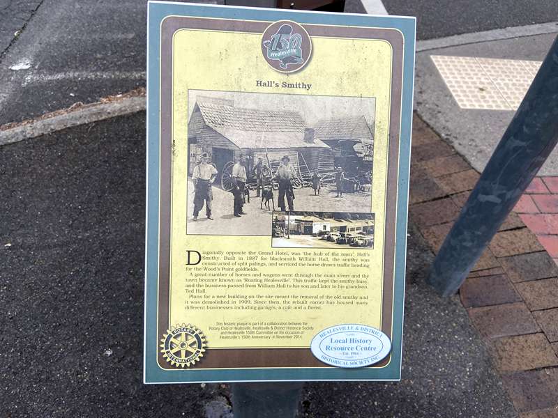
Diagonally opposite the Grand Hotel, was the 'hub of the town', Hall's Smithy. Built in 1887 for blacksmith William Hall, the smithy was constructed of split palings, and serviced the horse drawn traffic heading for the Wood's Point goldfields.
A great number of horses and wagons went through the main street and the town became known as 'Roaring Healesville'. This traffic kept the smithy busy, and the business passed from William Hall to his son and later to his grandson, Ted Hall.
Plans for a new building on the site meant the removal of the old smithy and it was demolished in 1909. Since then, the rebuilt corner has housed many different businesses including garages, a cafe and a florist.
14. Memorial Hall
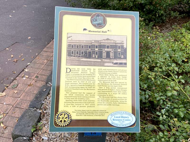
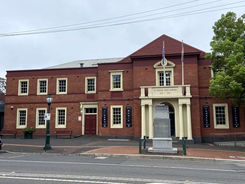
During the early 1920s the Healesville branch of the Returned Services League began a campaign for the building of a hall to commemorate local servicemen involved in the Great War (1914-18).
The Shire Council and the Mechanics Institute were in need of new and larger premises. The Council and the R.S.L. agreed to fund the building of a hall incorporating space for both the Council Chambers and the Mechanics Institute.
This proposal had the support of the whole community who keenly organised many fund-raising activities to help meet the building costs.
Sporting clubs held social activities donating the proceeds to the hall fund. A three-day carnival in 1921 raised 330 pounds, a mile of pennies produced 225 pounds, and entertainment and picture shows at the Palais Theatre raised the substantial sum of 800 pounds.
Dame Nellie Melba later performed a selection of works from Otello in 1928 to assist with funds for the maintenance of the hall.
The Memorial Hall was opened by His Excellency the Governor General Lord Forster on 2nd April 1924.
Over a long period, interspersed with periods of neglect, many changes and improvements have been made, culminating in a major $6 million restoration in 2012. The Memorial Hall has always been the main centre of social activities for the Healesville community, being the venue for concerts, balls, exhibitions, parties and public meetings.
15. French's Laundry
16. 'The Nook'
17. Timber tramway
18. Guest Houses
19. Queens Park & crossing
20. Old School site
21. Cornish Livery Stables
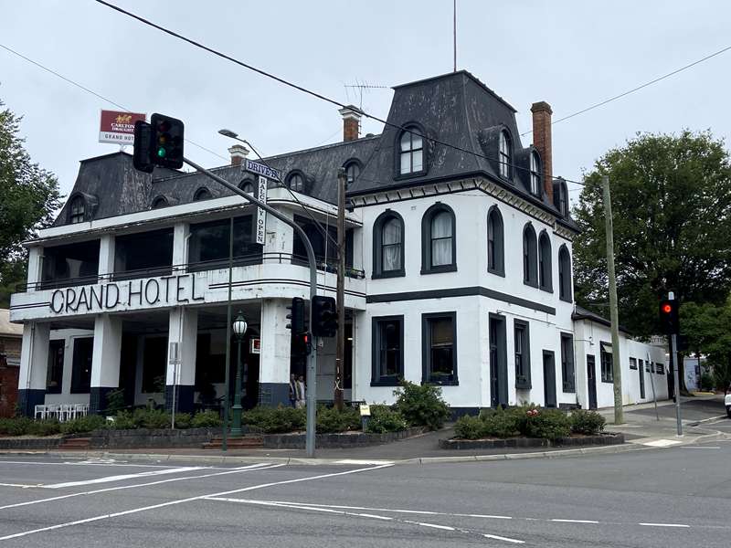
22. Grand Hotel
23. Early streetscape
24. Healesville Hotel
25. Cornish Buildings
26. Munro Shops
27. Mechanics Institute
Location
228 Maroondah Highway, Healesville 3777 View Map
Web Links
→ Healesville Historic Walk Brochure (PDF)


")