Gowar - School to Smiths Reef Walk

A walk of about 8.5 km from the old Gowar School through Smith's Reef Forest.
The walk starts at the old Gowar School. The school is about 10 km west of Castlemaine on the Castlemaine-Maldon Road. The ruin is at the start of the forest, on the right (north side).
All native plants and animals, and historic relics are protected.
Gowar School to Smiths Reef Walk Map
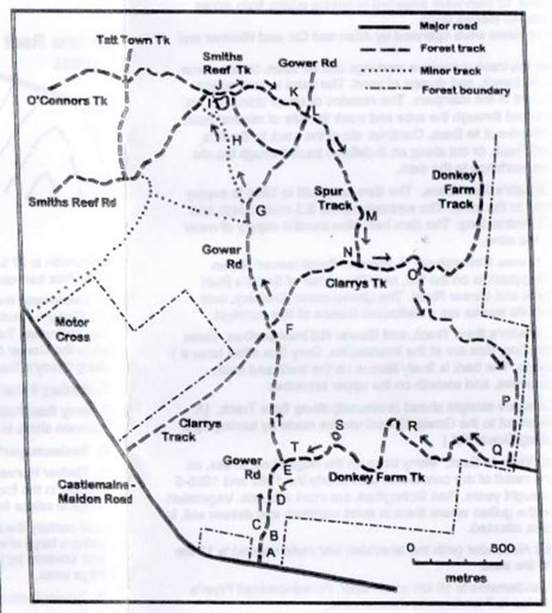
A. Ruins of Gowar School. Until 1880 Gowar (or Gower) was known as North Muckleford. The original school was about 1.5 km to the south and came under the control of the Board of Education in 1871, with William Willcox as head teacher. A 1.2 ha reserve was gazetted in 1873, and a new school was built. This was occupied in February 1874. It measured 9.1m x 5.5m. The walls were of stone with a shingle roof and pine floor. The building was unlined, and bitterly cold in winter. The average attendance in 1882 was 34, but declined to 20 in 1888. The attendance continued to decline, and the school closed permanently in 1908. The remains of an underground tank, which was used for drinking water, is on the west side of the school.
Yellow Gums are prominent around the school. A single Sugar Gum is growing just inside the fence line. Sugar Gums were often planted in school grounds, and may be the only obvious indication of a former school.
B. Sawpit Gully. The gully is on the east side of the school site, and runs northward. The rush to the gully at the end of 1857 was known as Sawpit Rush or Hunter's Rush. Most of the workings have been obliterated, but some workings can be seen to the right of the road.
C. Control burning. A narrow strip of forest bordering the Castlemaine - Maldon Road is burned regularly, as part of the district's fire control strategy.
D. Grey Box flats are on the right. Two eucalypt associations in the forest are:-
- Grey box with Yellow Gum, on the lower elevations. Soil is deeper than on the rises. Yellow Box may also be present. Understory is often sparse. Coffee Bush is the most common shrub.
- Mixed box/stringybark, on the rises. Major eucalypts are Mealy Bundy, Red Box and Red Stringybark. There may be a sparse understory, or tussock grass, or mixed shrubby understory.
E. Donkey Farm Track leads off to the right. A small Yellow Box is growing at the intersection. Tussock Grass understory can be seen.
F. Clarry's Track. Crossroad. Continue on Gowar Rd.
G. Track to Smith's Reef. Several minor tracks lead to the left. Take the track leading slightly uphill at 40 degrees to the main track, in a NW direction.
Most native species do not regenerate well in compacted soil and it may take many years for an old track to revert to forest.
H. Smith's Reef. The line of Smiths Reef was in a north-south direction. The Reef workings were operated by the Tarrengower Reform Quartz Mining Association. By 1860 a twenty-five horsepower engine worked 20 head of stampers to crush the quartz. Each stamper weighed 300 kg. The stamper operated day and night, and employed six men. Another 12 men were engaged in raising quartz from mines 25 and 40 metres deep.
Other mines were operated by Allen and Co. and Rimmer and Co.
Near the track numerous workings can be seen. Notice some old brickwork, and dumps of sand. The sand is from quartz crushed in the stampers. The remains of stone chimneys are scattered through the area and mark the site of miners' huts.
I. Short-cut to Dam. Continue along the track to Smith's Reef Track, or cut along an ill-defined track through the old mine workings to the dam.
J. Smith's Reef Dam. The dam was built in 1860 to supply water to the mine. The embankment is 6.3 metres high and 135 metres long. The dam held nine months supply of water for the mine.
K. Brown Stringybark. A stand of Small-leaved Brown Stringybark is on the left, near the corner of Smith's Reef Track and Gowar Road. The glossy-green, leathery, oval juvenile leaves are a distinctive feature of this eucalypt.
L. Smith's Reef Track and Gowar Rd intersection. Some fine Grey Box are at the intersection. Grey Box often have a Y shape. The bark is finely fibrous on the trunk and main branches, and smooth on the upper branches.
Continue straight ahead (eastward) along Spur Track. [A short-cut to the Gowar School can be made by turning right along Gowar Rd.]
M. View to East. Many trees on the ridge show stress, as the result of dry conditions, particularly the 1982 and 1995-6 drought years. Red Stringybark are most affected. Vegetation in the gullies where there is more moisture and deeper soil, is less affected.
Mt Alexander (with the television and radio towers) is 17 km to the east.
Castlemaine is 10 km south-west. Forest-covered Fryer's Ridge is 7 km beyond Castlemaine.
The track is close to the Muckleford Fault. Movement along the fault line elevated the land to the west. The fault extends for many kilometres in a north-south direction.
Total vertical movement was many hundreds of metres, and has continued over millions of years. Erosion has smoothed the fault line, and silt has been deposited along the Muckleford Creek Valley.
Mt Franklin is 27 km to the south in the direction of the track. This tree-covered hill is an extinct volcano.
N. Sandstone Reef is at the intersection of Spur Track and Clarry's Track. The reef is resistant to erosion and now protrudes. Turn left along Clarry's Track. [A short-cut to the Gowar School can be made by turning right along Clarry's Track to Gowar Road.]
O. Donkey Farm Track intersection. Turn right.
P. Grey Box/Yellow Gum forest. Coffee Bush is a common shrub in this association.
Q. Seelenmeyer's Road. Turn right.
R. Timber Harvesting Area. Each of the eucalypt species in the forest has distinctive sucker-leaves which range in colour from deep green to grey-blue.
Last century the central goldfields was described as being a large shrubbery. At this time, the goldfields area was covered by young coppice growth, and without large trees.
S. Gowar Dam is on the right.
T. Gowar Road. Turn left to Gower School and the valley of Back Creek.
CAUTION: Old mining areas may have deep unprotected shafts. Some shafts have been capped. The capping may become unstable with age. You are advised to keep to the defined tracks.
Things to look for:
- Kangaroos (usually in small mobs) and wallabies (usually alone).
- Plant associations. Look for changes in the eucalypt types. and the kind of understory, and the relationship with topography.
- The growth patterns of eucalypts. Multi-stemmed growth in the central goldfields is the result of coppicing. The size of the original tree can often be estimated.
- Small birds. If you see small birds, there will often be a range of other species nearby.
- Flocks of white-winged choughs. These magpie-sized birds are black, except for prominent white wing patches that are easily visible in flight. Their call is very distinctive.
- Ants nests. Look for evidence of digging in the larger nests, which is a sign that echidnas have been foraging.
- Leaves. Look for evidence of insect attack. Native plants provide food for insects and other small animals, which are in turn, food for larger animals.
- Evidence of mining activities. In the gully flats, most of the mining was small scale alluvial mining. Larger scale mining took place on the lines of reefs.
- Spring wildflowers. Many orchids. lilies and other wildflowers are prominent in spring.
Location
Cnr Castlemaine-Maldon Road and Gower Road, Gowar 3463 View Map


")