Golden Point - Chinamans Point to Expedition Pass Walk


A 4.6 km return walk along Forest Creek from Chinamans Point in Golden Point via Chewton to Expedition Pass Reservoir.
About the walk
Distance: Approximately 4.6 km return. Allow two and a half hours.
From the Castlemaine Tourist Information Centre, drive 5.2 km along the Highway to Chewton, and turn left along Golden Point Road for 1.4 km to Chinamans Point Road. The walk begins at a "carpark" between high gravel mounds (the remnants of dredging and gravel extraction). The trail follows Forest Creek north, upstream to Expedition Pass Reservoir for approximately 2 kilometres. Some of the walk is along unformed tracks. The walk is not suitable for wet weather, when the creek crossings may be impassable.
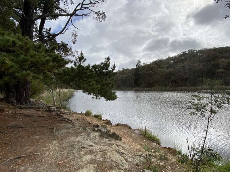
Forest Creek
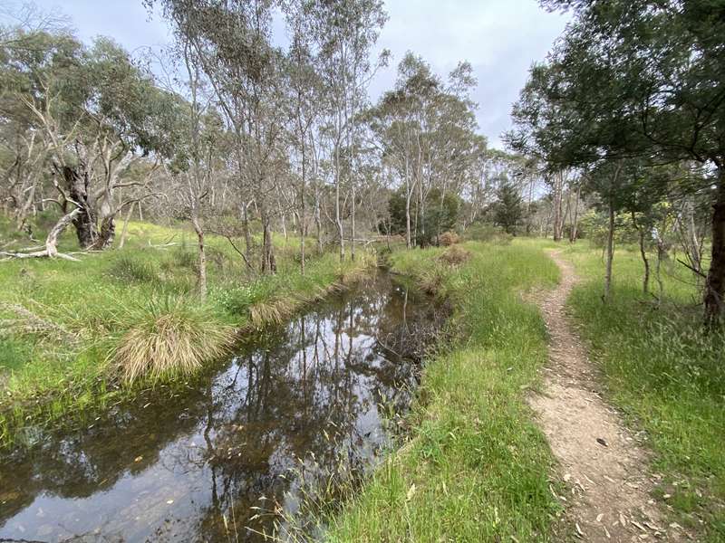
Forest Creek rises on Mount Alexander and flows south-westerly through Chewton to Castlemaine. There it joins Barkers Creek and becomes Campbells Creek, which feeds into the Loddon River at Guildford.
The original dwellers were the Dja Dja Wrung people who were able to hunt platypus, possum, echidna, kangaroo, wallaby and koala; collect a variety of tubers, flowers and seeds; and catch birds and reptiles to use for both their dietary and cultural needs.
In 1836 Major Mitchell's Australia Felix Expedition of thirteen wagons camped in an adjacent valley to Forest Creek. While camp was being set up, Mitchell with a guide Tommy Came-last set out to find a way through to Mt Byng (now Mt Alexander). They proceeded along the ridge to the west of Forest Creek to the summit of Mt Alexander. The expedition passed to the east side of Expedition Pass, where, as a result of "bad driving" a wagon was damaged. During the time it took for repairs, Mitchell lead a party south to Mt Macedon from where he could see the sails of ships at anchor at Melbourne.
After Mitchell reported back to England on the potential of the country, the first European settlers began to arrive. This fertile valley was taken up as part of the Strathloddon Run, and soon sheep were being grazed. However, this changed dramatically in 1851 with the discovery of gold. This was the catalyst for the world's largest mass migration, and Forest Creek became the world's richest alluvial goldfield. Ultimately there were 30,000 diggers on the field who came from all parts of the globe.
Chinamans Point refers to a bend in Forest Creek a little way downstream from the carpark. During the gold-rush quite a substantial Chinese settlement developed there. The Europeans considered themselves to be under threat from the "horde" A large meeting was held to consider how to oust the Chinese. Up until the early 1920s a Chinese market garden was still supplying fresh vegetables to families in the now established township of Chewton.
Chinamans Point to Expedition Pass Walk Map
The Walk
1. From the carpark, walk north, (upstream) between two gravel mounds, across an open area, then, bearing left, up a rise to a sharp drop down to the bottom of the gully. Standing here you can see the former depth of the creek valley floor. The soil profile shows the deposits made during different flows of the creek, as well as an indication of the amount of gravel that has been extracted.
2. Move to the creek edge and cross the stream where several large stones have been put in place. Depending on the time of year, and the amount of water being released from Expedition Pass Reservoir, the level of water at the crossing will vary.
3. Once you have crossed Forest Creek, continue in an easterly direction towards Golden Point Road, and you find a faint track which sweeps left skirting a grassed gravel mound. From here on, the track stays parallel with Golden Point Road [until you reach a derelict bridge at point 7]. Golden Point Road is on your right, and Forest Creek is on your left.
4. Walk upstream until you reach a well-used gravel road lined with poplars. Across Golden Point Road from here is Commissioners Gully Road. During the gold- rush there was a police camp established approximately 200 m. up the gully. Later in 1861 a dam was built here to provide water for the eastern part of Chewton, for a "sludge clogged creek", and for the mines which had to stop work in the dry summers. During the flood of 1889 the wall of the darn was breached and it has never been repaired.
5. Veer to the right to cross the gravel road and pick up the track, then continue between some old fences. It is near here that the track passes over the spot where gold was first found on Forest Creek.
6. Deviate around a swampy area and either travel up and over a gravel mound, or, pass below this mound along a short eroded stretch on its left. Past the mound is another escarpment which illustrates the depth of gravel deposited along Forest Creek over millions of years.
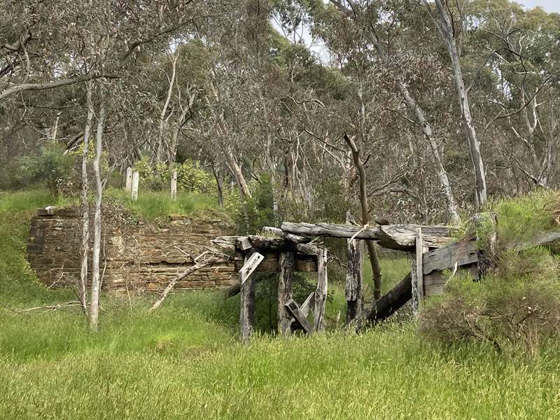
7. The track continues straight ahead and opens out with Golden Point Road nearby, on the right. Stop at the old bridge. A number of stone terraces can be seen on the opposite side of Golden Point Road . These are on private property. This was the site of the Northumberland Arms Hotel and Faraday Tea Gardens.

8. Pass under the bridge, cross a dip into a stand of young river red-gum (Eucalyptus camaldulensis), and veer left, following the western edge of the young trees until you reach the creek. Keep the creek on your left to Llewellyn Road.
9. Turn left to cross the creek via the ford, which can be flooded after heavy rain, then almost immediately, turn right off the road, and walk a short distance to a plain-wire fence.
10. Go through the fence. You are now in the reservoir reserve. Pick up the track which follows the creek until a short bank leads you up to a flat area.
11. Walk ahead to a fairly deep gully (Long Gully), cross this, then go up a heap of shale which was removed to form the overflow of Expedition Pass Reservoir. The cascades on the right are most picturesque even if there is only a small amount of water flowing over them. When there has been heavy rain they are spectacular. The cascades clearly indicate the line of the reef, which is in a north-south line.
12. Continue uphill, passing over the start of the water-race which carried the water to the mines in Chewton. Water was reticulated to homes in Chewton (and Castlemaine) by a wooden pipeline along Golden Point Road. Note on the right, a remnant length of steel pipe which, when joined with others crossed the overflow at this point to bring the water to the open race. A few metres on you reach the top of the overflow cutting and can look down on the reservoir.
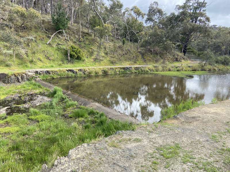
13. Move down to the water's edge for a snack. By 1960 the McCay Reservoir had been built and supplied domestic water to Chewton and Castlemaine. In 1994, Coliban Water considered that the water held in Expedition Pass Reservoir was superfluous to their requirements and intended to decommission the reservoir. In the process, one option was to breach the wall and release the water. This was objected to by the local residents, and ultimately the reservoir was offered to the Mount Alexander Shire for a peppercorn amount, with the Shire carrying out annual inspections of the stability of the retaining wall. At this time several repairs were carried out. The valve tower was removed, the outlet pipe was re-sleeved, and the water-level lowered by about a metre. The overflow had a central channel excavated to enable it to cope with the "one in one hundred years flood". A flood did occur on January 1st, 1889. The wall of water that rushed over the entire embankment was added to by the water that escaped from the Commissioner's Dam. It swirled into Chewton to flood the Frances Ormond Mine, trapping two miners down below, who were drowned. The bodies were entombed for several months before they could be recovered.
Expedition Pass Reservoir
After the initial gold-rush, followed by the growth of mines and the more permanent settlement of Chewton, the demand for water intensified, especially for the mines which were unable to work during the dry summers. The construction of Malmsbury Reservoir on the Coliban River lead to the desire to bring some of this water to the Chewton goldfields. Submissions to build a large reservoir near the diggings began in 1862. In 1867 tenders were let, and Expedition Pass Reservoir was completed in 1868. (What action!!) The reservoir was filled from natural rainfall which fell on the surrounding hills. However, to ensure a constant supply, the Coliban Channel was extended to deliver water from Malmsbury.
The water was released from the race upstream from the reservoir, above Dunstan's Flat. Fourteen masonry drops were constructed to prevent gully erosion as the water ran into the reservoir. These were known as Expedition Falls. Remnants of the falls are still present. In time, a boat-shed was built near where the cairn is now located and regular rowing events were held.
The Return Walk
14. Cross the overflow if the water level is not too high, then cross the embankment to the cairn commemorating Major Mitchell's Passage through here in 1836.
15. Walk down below the embankment along a narrow track past the site of the reservoir-keeper's (water bailiff's ) house to the granite masonry walls that protect the outlet valve. This is granite from Mt. Alexander - note the shaping of individual blocks and the decorative edging to each stone.
16. From here continue down to a clearly marked track and follow it to a vehicle gate. Pass under the bar and walk ten metres back to Llewellyn Road. Turn right downhill towards the ford which was crossed on the way to Expedition Pass Reservoir.
17. Before the ford turn left off Llewellyn Road and pick up the track. Follow it downstream to return to the carpark.
Access for Dogs:
Dogs are permitted on the walk on-leash but are excluded from the Expedition Pass Reservoir.
Information Signs
At the start of the walk there are some information signs with the following text.
Why is this place named Chinamans Point?
In 1854 when alluvial gold was becoming harder to find and many of the Australian and European diggers were moving to other fields, diggers from China began to arrive and soon outnumbered the people of European origin.
They worked diligently over the areas abandoned by others and were amazingly successful which caused resentment amongst other diggers.
A Chinese camp was established at Golden Point where they were given some protection from bigoted behaviour. Scuffles between the Chinese and others were, however, frequent and in July 1857 a large scale confrontation took place. About 200 Chinese were involved, apparently accused by some of them encroaching on their land. Several hundred other diggers, attracted by the disturbance, came to watch, many helping to prevent harm being inflicted on the Chinese.
The following week a meeting on the Chinese question was held in the Red Hill Music Hall. Six hundred and fifty people attended, making it the largest indoor meeting ever held in Chewton. Strong opinions were expressed but the meeting remained orderly.
The greatest fear appeared to be that a continuous influx of Chinese would mean that they outnumbered Europeans in the colony and it was felt that the government should take steps to prevent more arriving while continuing to provide protection to those already here.
Most of the Chinese returned home in the 1860s, but there was still a Chinese gardener at Golden Point at the beginning of the 1900s.
Layers of change
Forest Creek Track to the north of Chinamans Point passes along escarpments that illustrate the depth of gravels and silts deposited over millions of years, now exposed by mining activities and erosion. It is difficult to imagine the original creek route or elevation. Early maps show the creek at times on opposite sides of the valley to its path today.
The 1890s resurgence of mining activities introduced even more destructive gold retrieval methods. Sluicing used high powered jets of water blasting the creek banks and surrounding gullies. The resulting gravel and silt slurry was then run through a sluice box and the heavy gold collected. The refuse gravel was deposited back onto the creek and became a valuable resource for road making.
The Golden Point or Endall's Dredge operated in this area of Forest Creek as far north as Donkey Gully from 1903 to 1911. 59 acres of creek flats were reworked yielding a further 10,500 ounces (almost 300 kgs) of gold.
Today the exposed banks are important nesting and roosting habitat for birds such as the Spotted Pardalote which drills its nesting tunnel into the sandy sediments, the Rainbow Bee-eater and the White-backed Swallow. Mammals such as the echidna have nesting burrows in the banks, and crevices are home to bats and skinks.
Today the diggings you are likely to encounter along the creek are surface scratchings, seemingly random but often widespread. Echidnas and large flocks of White-winged Choughs create these when foraging for insects in the leaf litter and on the still bare mullock heaps of last century. This is a good sign that insect life has reinhabited the overturned soils and gravel.
A determined prospector
Echidnas are usually solitary, moving widely throughout their home range. They use sharp claws to dig and a pointed beak to feed on ants, termites, grubs and worms, often creating an area of extensive disturbance around an ant's nest or fallen timber harbouring termites.
They are active and often observed in the breeding season of late spring, when they may form 'trains' with several males following end to end after a female.
Today's recreational prospectors are still required to hold a Miner's Right and operate under a Code of Practice respecting and not disturbing sites of Aboriginal or historic heritage and significance. Damage to native vegetation is not permitted and the area of works must be immediately restored.
Tree huggers
Brush-tailed Phascogales, also known as Tuans, are listed as endangered and are reliant on hollow-bearing trees which are a rarity in this disturbed landscape. They feed on insects gleaned from under tree bark, the nectar of flowering eucalypts, and bird eggs and nestlings found in the canopy.
A funded program of installing and monitoring nesting boxes in the Castlemaine Diggings National Heritage Park and adjacent land specifically for use by the threatened Phascogale, is one way of helping these woodland dwellers survive. It is however, not unusual for other marsupials such as Sugar Gliders, or for bees and parrots to move into these ready-made homes.
Review:
This is a delightful walk in an interesting environment with the highlight being Expedition Pass Reservoir. At the carpark there is an unshaded seat. The route follows the lovely Forest Creek and is well sign-posted with poles with red tips for markers. Along the route there were lots of wildflowers in Spring.
When you come to a derelict bridge there is a seat (Barbara's rest) to rest on. A short path leads to an interesting diversion at 282 Golden Point Road where there is a massive rainbow unicorn in a paddock with emus, llamas, sheep and goats. There are some rock terraces here which was the former site of the Northumberland Arms Hotel and Faradays Tea Gardens.
You will reach an interesting area where the overflow is located (points 13 and 14 on the map). If the water level is low enough you can cross the concrete lip of the overflow channel for some extra exploration.
Photos:
Location
Chinamans Point Road, Golden Point 3451 View Map
Web Links
→ www.parks.vic.gov.au/places-to-see/sites/expedition-pass-reservoir


")