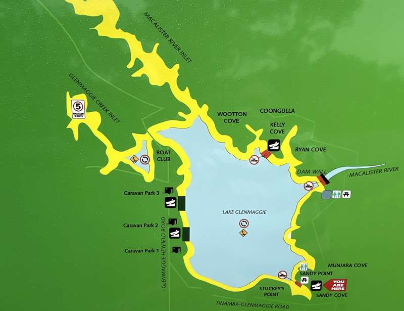
Glenmaggie - Lake Glenmaggie


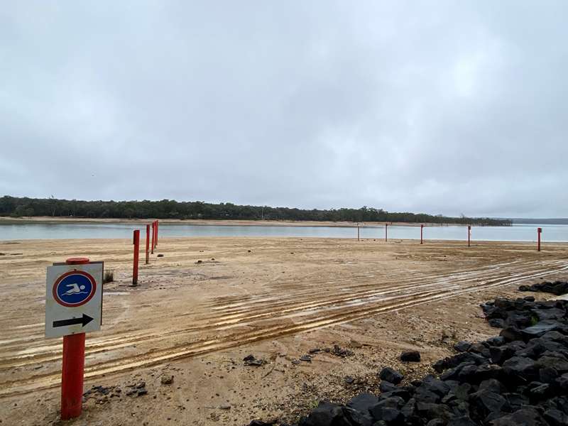
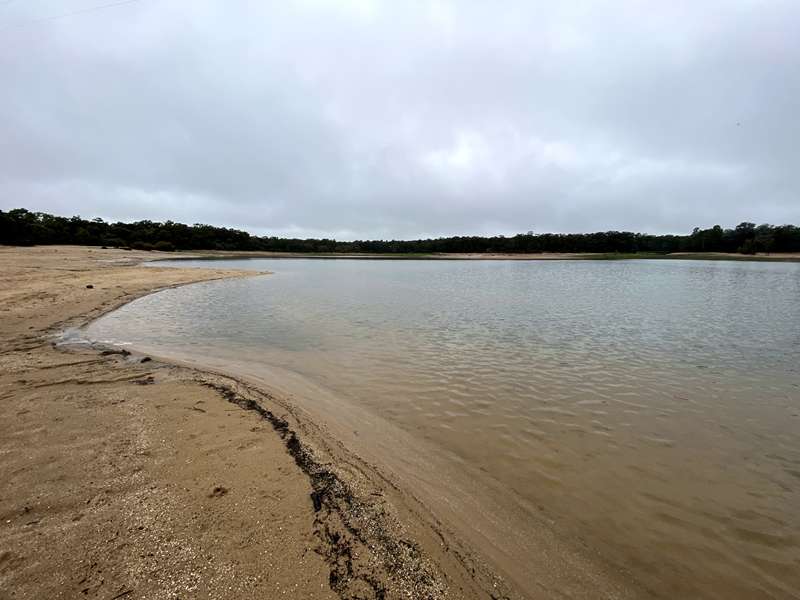
Lake Glenmaggie is an annual storage which provides water for farmers throughout the Macalister Irrigation District. This means that the lake fills and empties most years. If rainfall has been high leading in to summer, good swimming may extend through the warmer months.
Lake Glenmaggie is popular for boating, fishing, swimming and picnics. Camping is available at the privately operated Lake Glenmaggie Caravan Park. See the Lake Glenmaggie boating rules. Boating restrictions at Glenmaggie will change with water levels.
Lake Glenmaggie Map
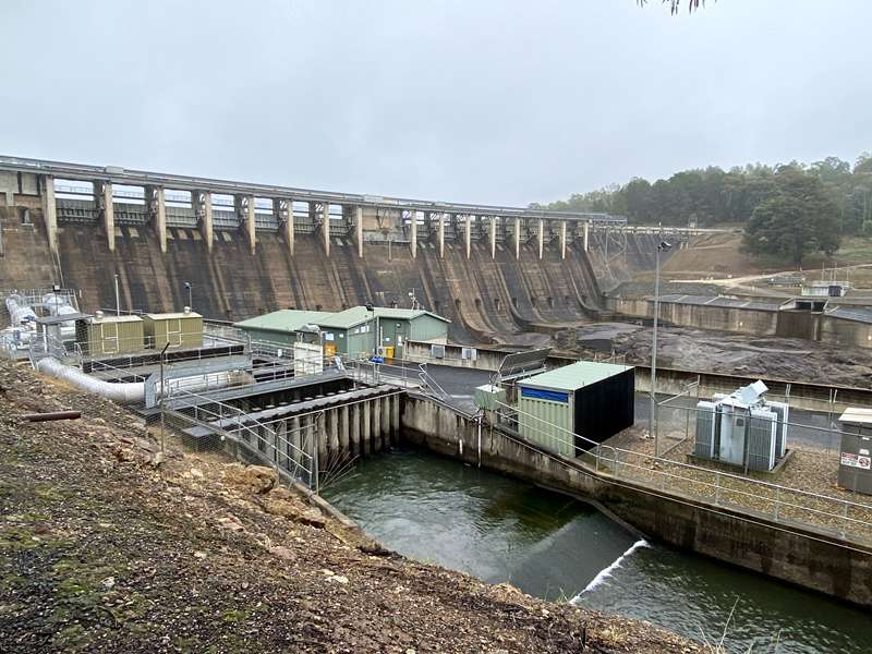
Facilities at the Dam Wall
Facilities and activities includes carparking, toilets, BBQs, views of the dam weir and playground.
Located off 823 Weir Road.
Please note: There is no public access for any activity beyond the barrier near the weir wall.
Information Signs
There are a number of information panels and displays:
Wirraway Aircraft Crash
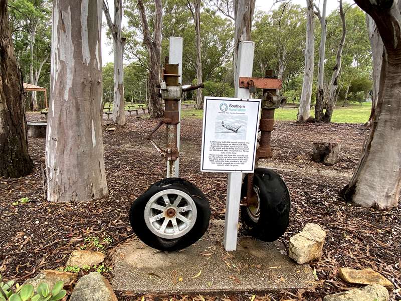
A Wirraway A20-404 aircraft crashed into Lake Glenmagqie on 14th March 1942. Tragically the pilot, aged 25 years died in the crash and his body was recovered on 18th March 1942. The pilot was flying solo at the time. These remains are from the aircraft and are the wheels and oleo strut taken from the plane when it was recovered in May 1980, when the Lake reached a 36 year low record, enough to recover the aircraft after 38 years.
Outlet Valve
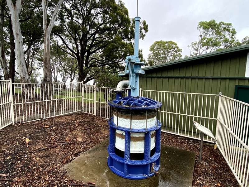
This outlet valve is one of three installed as part of the original construction at Glenmaggie Reservoir. This construction work began in 1919 and was completed in 1927.
Each valve was made from gunmetal cast iron, had an internal diameter of 914mm and weighed nearly four tonnes.
These valves were embedded in concrete at the base of the wall on the northern side of the dam. They enabled the release of water from the lake into the Northern Channel. This water was used for irrigation within the Macalister Irrigation District.
Water entered a valve via openings around the circumference of the valve and was controlled by an internal rising cylinder, connected to a vertical control shaft. As the internal cylinder rose, it exposed the openings in the external cylinder and allowed water to pass through the valve.
Water exited a valve through its base, opening into pipes under the dam. All three valves were operated by hand via a vertical shaft that ran from the valves to the operating deck of the dam wall. Similar valves used to release water from the central and southern outlets were also removed from service in 1957.
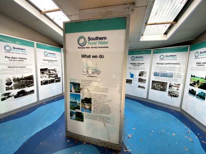
Pre dam history
THE SETTLEMENT
The first settler at Glenmaggie was Malcolm MacFarlane who arrived in Australia in 1838. MacFarlane saw Glenmaggie in 1841 and settled there some 15 years later to run sheep and cattle. During the late 1860s settlement increased rapidly and the township of Glenmaggie developed during the 1870s and 1880s.
IRRIGATION DEMAND
The earliest recorded public comment suggesting the damming of the Macalister River for irrigation was in 1886. Local interest and pressure for a dam grew particularly following the 1914 drought, the First World War and the introduction of the Soldier Settlement Act. The principal agriculture in the area at the time was maize, sugar beet and fodder crops. A scheme to build a dam was approved by the Government in mid-1919 and work commenced the same year.
Construction years 1919 to 1925
In 1919, construction work commenced on the present Glenmaggie dam site. This location was chosen over a proposed alternative site on the Avon River. Mass concrete was used, employing locally available materials.
A small township grew at the site, known as Glenmaggie Dam where employees and families lived for up to ten years while the dam and the irrigation channel networks were being constructed.
Construction years 1955 to 1957
The dam's storage volume was increased between 1955 and 1957 by adding steel gates to the existing structure. At the same time, twin pipes that form the Southern Outlet were also installed to increase supply to the Main Southern Channel.
Construction years 1987 to 1989
From 1987 to 1989, further construction work was undertaken on the dam to strengthen its resistance to earthquakes and major floods.
Ground anchors
Ground anchors are used on many concrete dams to improve their resistance to earthquake loads and overturning forces from floods.
Simply explained, holes are drilled through the concrete wall into a rock foundation and steel cables are then inserted. The lower end of the cable is grouted securely into the rockbed, whilst the upper section of cable remains free to move within the hole. The cables are then tensioned by means of a hydraulic jack, and "locked off' like a stretched elastic band.
This technique enables the dam to be held down more securely, increasing the frictional resistance to movement and overturning.
Macalister River Catchment
The two main contributing streams to Lake Glenmaggie are the Macalister River to the north of the reservoir and Glonmaggie Creek to the west. The source of the Macalister River is in the Great Dividing Range beyond Glencairn. Glenmaggie Creek commences within the Macalister River catchment. Water from the Macalister River catchment is harvested and stored at Glenmaggie Dam, and then released to the environment and irrigators within the Macalister Irrigation District.
Connecting Glenmaggie to the District
The dam at Glenmaggie was constructed to hold back water in the Macalister River for irrigation purposes. Initially Glenmaggie held 130,000 ML but since the upgrade works in the 1950s, its capacity has increased to 190,000 ML.
Today, Lake Glenmaggie supplies irrigation water to the Macalister Irrigation District via the Main Northern Channel and the Main Southern Channel and the Main Eastern Channel/Macalister River. This irrigation district, the largest south of the Great Dividing Range, covers approximately 53,000 hectares. Almost 80% of this land is used for dairy and is home to approximately 100,000 dairy cows. The Main Northern Channel has a capacity of 600 ML/day and supplies water to Newry and the Avon valley at Boisdale.
The Main Southern Channel has a capacity of 1,100 ML/day and supplies Tinamba, Riverslea and the Nambrok Denison plains. The supply to the Nambrok/Denison area is supplemented by water from the Cowwarr Channel, diverted from the Thomson River.
The Main Eastern Channel has a capacity of 450 ML/day and supplies the Airly, Myrtlebank and Sale areas. Water in the Main Eastern Channel is released from Lake Glenmaggie into the Macalister River and diverted by the Maffra Weir into the channel network.
Across the Macalister Irrigation District there are nearly 600 kilometres of open, earthen channels and 40 kilometres of pipelines. Most of the area, 93%, is flood irrigated and the remaining 7% is spray irrigated. As water is precious, it needs to be stared, managed and delivered efficiently.
Commercial Water Use
Glenmaggie provides water for many competing uses but its primary function is to provide water for agricultural use. In the Macalister Irrigation District, the dairy industry is by far the largest user. Other agricultural uses include vegetable growing, crops and beef cattle.
Leisure Water Use
In addition to the commercial demands on Lake Glenmaggie, the stored water provides opportunities for a wide variety of leisure activities on the lake, its surrounding land and downstream on the Macalister River. Environmental flows from Glenmaggie Reservoir ensure that the health of the Macalister River is protected.
Power Generation
In May 1994 Pacific Hydro Investments completed the installation of two power generation turbines at Lake Glenmaggie. These turbines utilise water released for irrigation or flows to the Macalister River and are capable of producing a maximum of 38 megawatts of power which is directed into the state grid. The station is operated from Young in New South Wales, by Country Energy and a small royalty is paid to Southern Rural Water based on energy generated.
Floods
Lake Glenmaggie is a unique large storage in Victoria, because it fills and spills nine out of every ten years.
In contrast, the Thompson Reservoir, Melbourne?s main water source, has a catchment area of only 25% of Lake Glenmaggie but can store five times more water. Lake Glenmaggie's large catchment means that river flows can be quite extreme during high rainfall. When we are in flood, we release water in a way that minimises risk to the dam wall while also trying to reduce flood damage downstream.
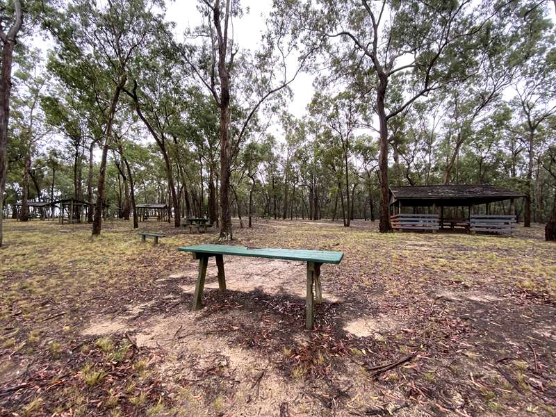
Facilities at the Sandy Point
Facilities and activities includes carparking, toilets, unshaded picnic tables (6x), shelter with four tables (1x), shelter with 1 table (4x), swimming (designated swimming area which is dependent on water levels), fishing, boating and kayaking.
Sandy Point Picnic Area is located in the south-east corner of Lake Glenmaggie along Sandy Point Road.
The following are not permitted:
- Camp or stay overnight
- Have fires or fire pits
- Leave rubbish - all the sites are carry in carry out zones
- Reserve any picnic areas
- Drive or ride motorbikes along the shoreline or in fenced areas
- Boats containing sleeping accommodation and / or toilets are prohibited on this reservoir.
- Enter prohibited areas
- Hunt, carry or discharge a firearm
- Ride or walk horses anywhere, including in the water.
- Use the park or picnic areas outside of opening hours
- Undertake any dangerous activities including abseiling, paraflying, shooting and archery.
Cost:
There is no entry fee into Glenmaggie Reservoir. Picnic areas cannot be reserved.
Access for Dogs:
Dogs are permitted on leash.
Photos:
Location
Glenmaggie Road, Glenmaggie 3858 View Map
Web Links
→ www.srw.com.au/recreation/locations/lake-glenmaggie


")