Forrest Mountain Bike Trails



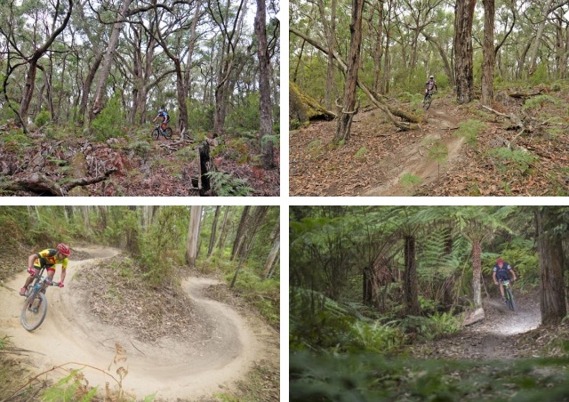
A network of over 100km of sustainable, cross-country mountain bike trails in the picturesque Otway Ranges near the small township of Forrest.
The Forrest Mountain Bike Trails are one of Australia's premier cross-country mountain biking destinations, attracting riders from across the country to the spectacular forests of the Otways. The extensive network winds through towering Mountain Ash forest, fern-filled gullies and open woodland, offering everything from gentle family rides to technically challenging singletrack.
Following a major expansion completed in 2023, the network now features almost 100 kilometres of purpose-built singletrack across 36 trails, divided into two distinct riding areas. The Southern Network offers flowing trails through lush forest with beginner-friendly loops, adaptive mountain bike trails, skills parks, pump tracks and more technical descents. The Northern (Yaugher) Network provides longer and more demanding rides through drier woodland with challenging climbs, fast descents and rewarding views.
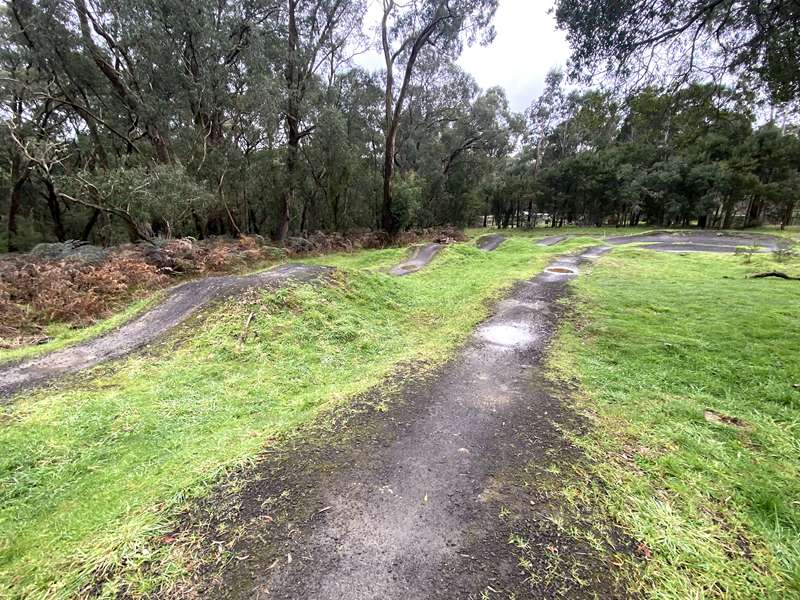
The Southern Trailhead includes excellent rider facilities including parking, toilets, drinking water, bike wash facilities, picnic shelters, a pump track, skills park and adaptive mountain bike infrastructure. Several trails have been specifically designed to accommodate adaptive mountain bikes, making Forrest one of Australia's leading inclusive mountain bike destinations.
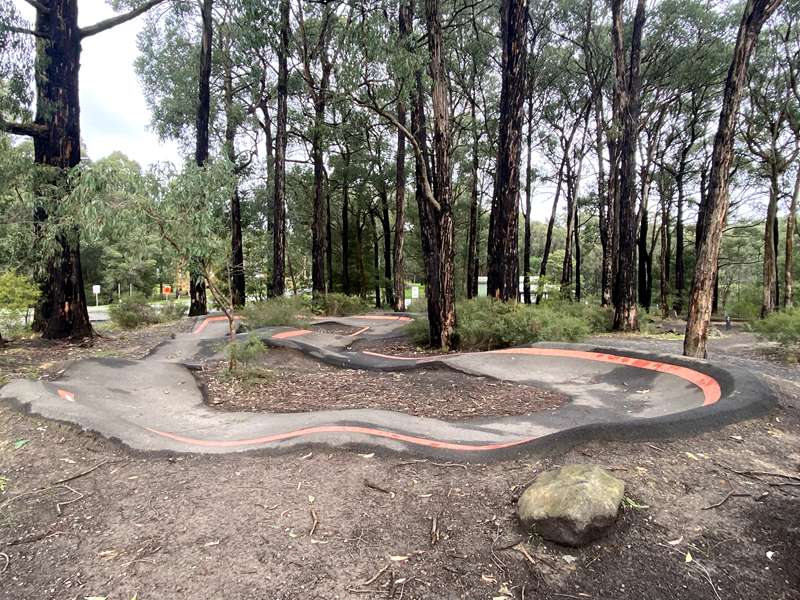
Pump Track (Beginners)
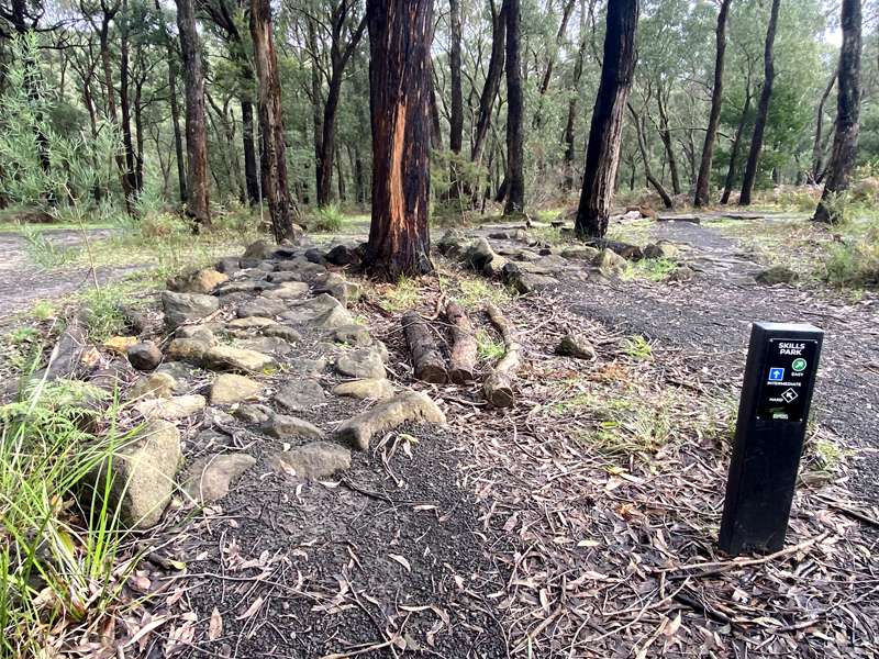
Skills Track
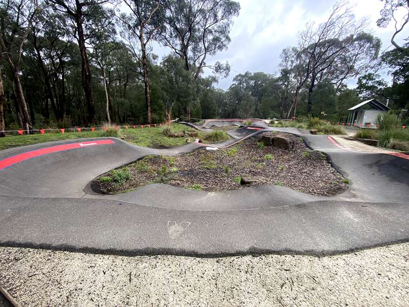
Pump Track (Intermediate)
Jumps Track
Forrest itself is designed as a true ride-in, ride-out mountain biking town. Riders can pedal directly from the township to both trail networks and enjoy cafés, accommodation, bike hire and repairs without needing to drive between rides.
Trailheads
The Forrest Mountain Bike Trails have two main trailheads:
Forrest Southern MTB Trailhead
Location: Off Grant Street, Forrest (near Rivedell Lane)
This is the main trailhead and includes a large car park, accessible toilets, drinking water, skills park, two pump tracks (one for beginners and another for more experienced riders), jumps track, bike repair station, sanitation station, picnic shelters and trail information boards. It is within easy walking distance of cafés, accommodation and Forrest MTB Hire.
Forrest Yaugher MTB Trailhead
Location: On Boundary Road, just off the Birregurra–Forrest Road (C155) at Yaugher, about 5 km north of Forrest.
Provides access to the northern (Yaugher) trail network, including trails such as Grass Trees, Marriners Run, Vista and the Yaugher Super Loop. It has parking and toilets but fewer facilities than the Southern Trailhead.
Trails in SOUTHERN network
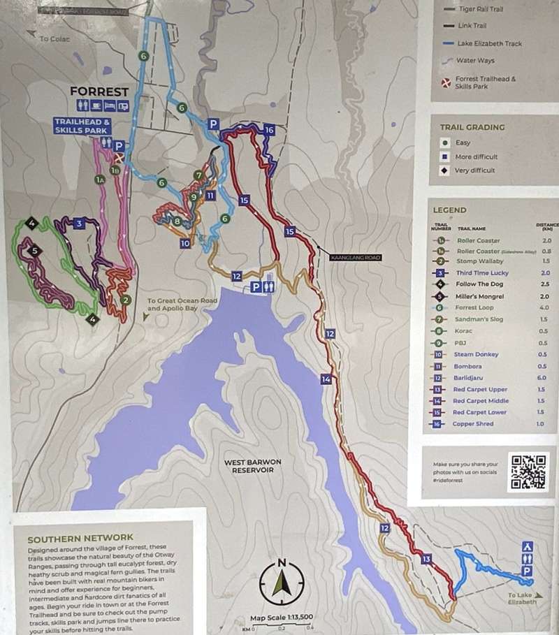
| Trail No. | Trail Name | Distance (km) |
| 1a | Roller Coaster (Connecting to the Forrest Mountain Bike Trails trailhead, Roller Coaster takes you on a wide, smooth and free flowing trail. With no obstacles it is ideal for beginners or a quick warm up lap before heading out on a more extended ride) (Green easy level) | 2.0 |
| 1b | Roller Coaster (Sideshow Alley) (Green easy level) | 0.8 |
| 2 | Stomp Wallaby (Green easy level) | 1.5 |
| 3 | Third Time Lucky (Third Time Lucky has plenty of trail features including bermed corners and jumps. This is an excellent trail to learn the different skills needed for mountain biking while enjoying the thrilling sensation of riding through the bush (Blue intermediate level) | 2.0 |
| 4 | Follow The Dog (This free flowing trail through tall open eucalypt forest and dense fern gullies offers extended riding with loads of trail features along the way. Long climbs and fast flowing descents characterise this exciting trail) (Black difficult level) | 2.5 |
| 5 | Miller's Mongrel (Black difficult level) | 2.0 |
| 6 | Forrest Loop (The Forrest Town Loop is a dual use trail for walkers and cyclists of all abilities. It has long flowing corners that descend to the West Barwon valley and then climbs back to Forrest where it joins the Forrest Heritage Trail) (Green easy level) | 4.0 |
| 7 | Sandman's Slog (Green easy level) | 1.5 |
| 8 | Korac (Green easy level) | 0.5 |
| 9 | PBJ (Green easy level) | 0.5 |
| 10 | Steam Donkey (Blue intermediate level) | 0.5 |
| 11 | Bombora (Blue intermediate level) | 0.5 |
| 12 | Barlidjaru ( The local indigenous word for Platypus is Barlidjaru, (bar-lid-ja-ru). This trail links Forrest to Lake Elizabeth and climbs most of the way to the Lake Elizabeth carpark.You can leave your bike here and enjoy a walk to the Lake and maybe catch a glimpse of one of the lake's resident platypus) (Blue intermediate level) | 6.0 |
| 13 | Red Carpet Upper (The Red Carpet is a single track return trail from Lake Elizabeth. This trail flows through tall Eucalypt forests featuring fun, challenging descents and tight technical climbs for an exciting return option to Forrest) (Blue intermediate level) | 1.5 |
| 14 | Red Carpet Middle (Blue intermediate level) | 1.5 |
| 15 | Red Carpet Lower (Blue intermediate level) | 1.5 |
| 16 | Copper Shred (Blue intermediate level) | 1.0 |
Some Key Runs in SOUTHERN area
-1- BEGINNNER RUN
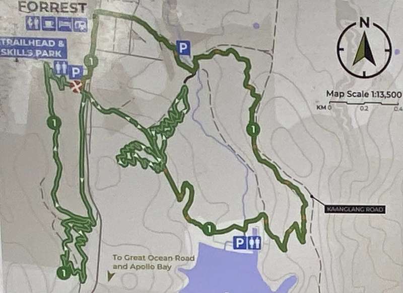
Distance: Short – 7.3 km / Long – 11 km
Trail Grading: Easy. Progress your riding with this fun course suitable for all ability levels.
- Leave Trailhead on Roller Coaster
- Ride Stomp Wallaby
- Return to Trailhead via Roller Coaster
- Ride Forrest Loop to Spaghetti Junction
- Ride Sandman's Slog
- Descend on Korac & PBJ Down
- Return to Trailhead via Sandman's Slog. Option: Continue down Forrest Loop to Barlidjaru to test yourself on some intermediate trails.
- Climb Barlidjaru until first intersection and descend Red Carpet
- Join Copper Shred
- Ride up Kaanglang Road onto Forrest Loop and return to Trailhead.
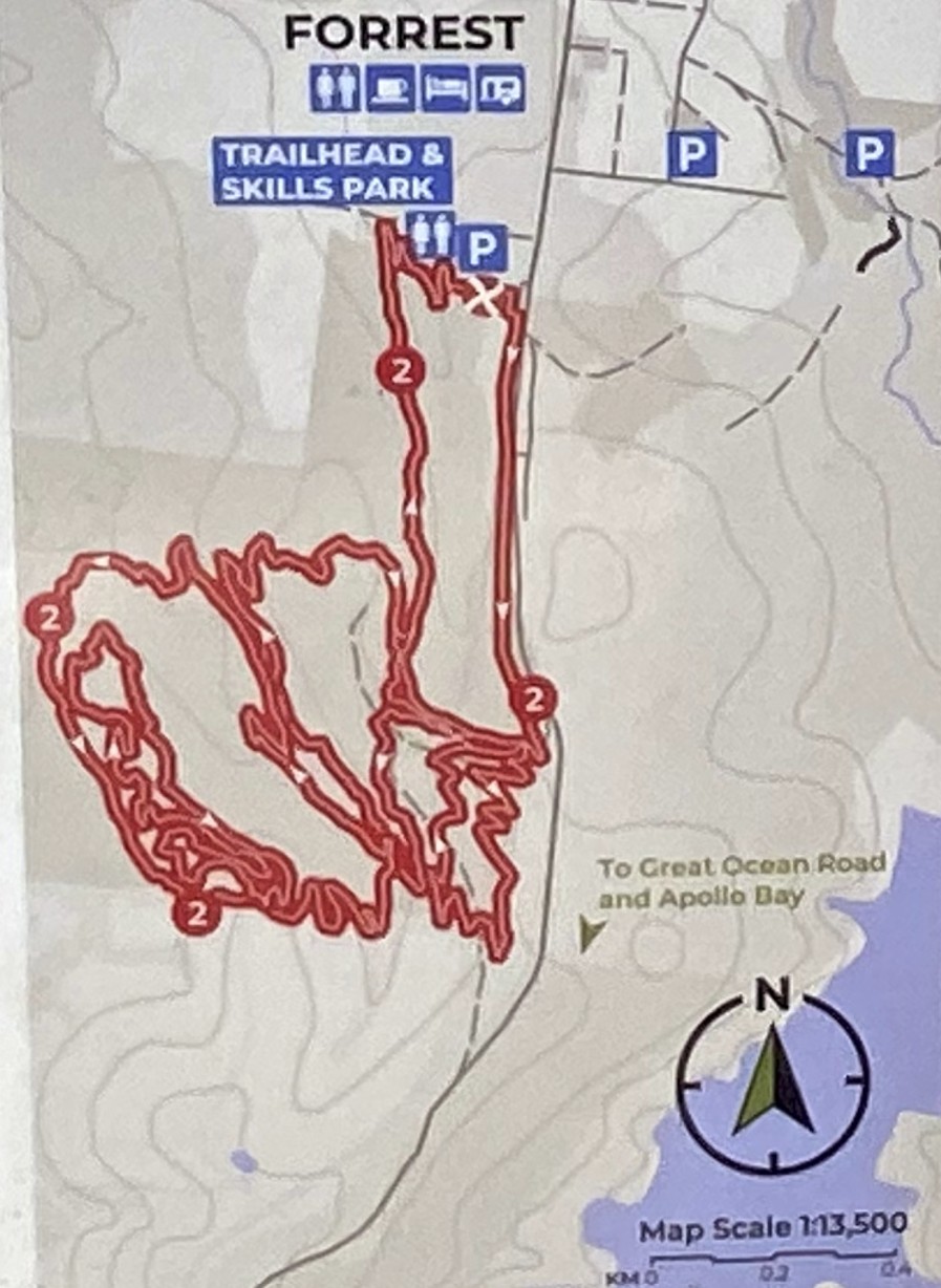
Distance: 10.2 km
Trail Grading: Advanced. Fun flowing features with challenging climbs in and out of gullies.
- Ride Roller Coaster to start of Stomp Wallaby
- Complete Stomp Wallaby
- Ride Third Time Lucky to start of Follow the Dog
- Complete Follow the Dog including Millers Mongrel
- Return to Trailhead via rest of Third Time Lucky and Roller Coaster
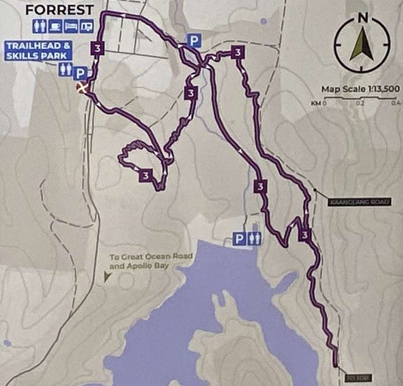
Distance: 14 km
Trail Grading: Intermediate. Enjoy the best flow trails on the network all in one go.
- Leave Trailhead on Forrest Loop
- Ascend Sandman's Slog at Spaghetti Junction
- Descend on Steam Donkey & Bombora
- Rejoin Forrest Loop using link trail
- Cross Barwon River on Kaanglang Road
- Ride along Barwon River on Red Carpet to Barlidjaru
- Ascend Barlidjaru to top of Red Carpet
- Ride all sections of Red Carpet to bottom
- Return to Trailhead via Kaanglang Road and Forrest Loop
Trails in YAUGHER network
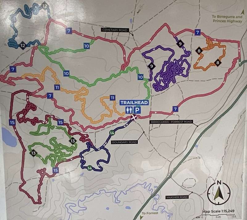
| Trail No. | Trail Name | Distance (km) |
| 7 | Yaugher Super Loop (The Yaugher Super Loop provides access to the entire Yaugher trail network. It is a mixture of single track and fire trails with a full range of trail features all with A and B lines) (Blue intermediate level) | 11.5 |
| 8 | Grass Trees (Grasstrees packs enough technical features and variety to challenge all riders. Extensive trail features include log rides, rollovers, step ups, drop offs, big 4X berms and jumps) (Black difficult level) | 1.5 |
| 9 | Marriners Run (With long climbs and fast flowing descents, this trail will test your limits. The middle section has enough technical features to pack a punch for the most experienced rider) (Black difficult level) | 4.5 |
| 10 | Foxtail (Long fast straights and open corners provide a fun flowing ride with well spaced technical features. This trail takes you from the Yaugher trailhead to Tabletop and on to join the Yaugher Super Loop) (Blue intermediate level) | 3.5 |
| 11 | J2 (Another long flowing descent trail from the Yaugher trailhead. This trail has plenty of features along the way and joins the Yaugher Super Loop for a quick lap) (Blue intermediate level) | 4.0 |
| 12 | Yo Yo (A tight and technical trail that as the name suggests goes up and down to test your legs, lungs and skills) (Black difficult level) | 3.0 |
| 13 | Casper Black (Twisting technical climbs and descents with walls of tea tree characterise this tough and challenging trail (Black difficult level) | 5.5 |
| 14 | Barre Warre (The Barwon River takes its name from the local indigenous word Barre Warre (Bar-rah War-rah) meaning from hills to sea. This high vantage point looks down on the Barwon River valley taking in the view back over the Forrest Township. A good warm up or warm down ride) (Green easy level) | 2.0 |
| 15 | Vista (This long flowing trail has some great fire trail descents and climbs with rewarding valley views. The southern loop has some tough technical climbing thrown in for good measure) (Blue intermediate level) | 5.5 |
Trail Map:
Forrest Mountain Bike Trail Map (Trailforks)
Rider Information
RIDER ETIQUETTE
- When on shared trails give way to walkers and horse riders.
- If you want to overtake another rider call out to them "On Your Right" and pass on their right-hand side.
- If you hear someone call to you try and move to the side of the trail if safe to do so, to let them pass.
- Only ride on designated trails – don't cut corners or cut in new trail.
- Do not alter features or build new features on the trails.
- Respect trail closures.
- Respect the bush.
RIDER SAFETY
- Always wear a helmet! Gloves and eye protection are highly recommended.
- Check your bike is in good working order – especially the brakes. If you need to make adjustments there are tools available at the trailheads.
- Obey all directional signage. Heed warning signs on the network.
- When riding a new trail, do a scouting or practice run first. You can go faster next time. Watch out for other riders.
- Be cautious when riding in wet, windy or hot conditions.
- Take water and a mobile phone with you.
- Understand the grading system and check the difficulty of a trail before riding on it. If you are unsure about a feature or section there is no shame in walking your bike around it.
Easy (Green)
- Wide trail with a gentle gradient and smooth surface. Some obstacles such as logs. Suitable for beginner cyclists with basic skills and off-road bikes.
More difficult (Blue)
- Single trail with moderate gradients including some steep sections. Trails will include obstacles such as roots, drop-offs and table top jumps that may be unavoidable. Suitable for competent mountain bikers on mountain bikes.
Very difficult (Black)
- Challenging single track including long steep climbs and steep descents. Includes technical features that are unavoidable. Suitable for experienced mountain bikers.
SHARED TRAIL LIST
Walkers - Forrest Loop, Barlidjaru, Lake Elizabeth Track, Tiger Rail Trail
Horse Riders - Yaugher Super Loop, Tiger Rail Trail
No horses or walkers on any other trails.
OTHER INFORMATION
Only bikes and e-bikes are allowed on the trails (no trail bikes).
HABITATS ARE HOMES
Minimise the spread of dieback. Arrive clean and leave clean.
PHYTOPHTHORA DIEBACK
Dieback (Phytophthora cinnamomi) is an introduced plant pathogen that devastates native plant communities and is a key threatening process to Australia's biodiversity. The pathogen lives in soil, water and plant material. It attacks roots, restricts the uptake of nutrients and kills plants that small mammals, birds and insects rely on for shelter.
Dieback kills the plants that small mammals, birds and insects rely on for food and homes. Grass trees that take hundreds of years to grow are particularly susceptible to the disease. Habitat infested with dieback can no longer support populations of mammals like bandicoots, swamp antechinus and potoroos.
Once an area is infected, there is no cure, so preventing the spread of dieback is critical. Human activity causes the spread of the pathogen through the movement of infected material. Practising strict hygiene and removing soil from tyres and footwear is essential in managing dieback.
How you can help to protect the bush.
Be aware of dieback and what infected areas look like. Reduce soil and plant material movement by staying on established tracks and following directions on signs concerning dieback.
Use sanitation stations to ensure your bike and footwear are clean and free from dirt or organic material. Roll bike tyres through the station to remove soil and disinfect them. Brush boots to remove soil and use the foot pad to disinfect footwear. Repeat the cleaning process before and after entering the bushland.
Photos:
Location
5 Rivedell Lane, Forrest 3236 View Map
Web Links
→ visitgreatoceanroad.org.au/rideforrest
→ Forrest Mountain Bike & Cycling Club on Facebook
→ Mountain Bike (MTB) Parks in Melbourne and Victoria
→ www.exploreoutdoors.vic.gov.au/activities/mountain-biking/forrest-mountain-bike-trails


