Falls Creek - Around the Historic Huts of Falls Creek


Walking is one of the best ways to discover the variety and beauty of the alpine environment including these iconic huts. The walking season lasts from early November until late May as the area is usually snow covered during winter and early spring.
Location of Historic Huts
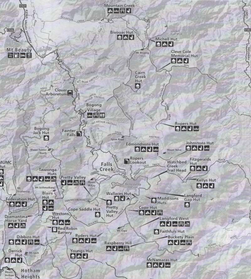
Wallace Hut (1.5 km, approx 45 minutes return)
The walking track to Wallace Hut commences 7.7 km along the Bogong High Plains Road from the Rocky Valley dam wall. Park your car on the side of the road and walk down the short well-graded track to Wallace Hut. Built in 1889 from Snow Gum slabs and Woollybutt shingles, this timeworn cattleman's but is thought to be the oldest on the high plains.
Cope Hut (0.5 km, approx 15 minutes return)
The track to Cope Hut commences a further 2 km along the Bogong High Plains Road. Cope Hut was built by the Ski Club of Victoria in 1929 after the state experienced a surge in skiing in the 1920s. The but was called "The Menzies of the High Plains" by early skiers and walkers because of its size and comfort.
Wallace to Cope Heritage Trail (6 km, approx 2.5 hours return)
Start with the walk to Wallace Hut and continue past the but to the aqueduct. Cross the aqueduct and turn right onto the Australian Alps Walking Track (AAWT). The track takes you past the Rover Chalet. Turn right at the "T" junction about 200 metres past the creek crossing and follow the track up to Cope Hut and the Bogong High Plains Road. Return to the start along the road or by taking the walking track down a heath-filled valley to the Wallace Hut Track.
Fitzgerald Hut and Kelly Hut (10 km, approx 4 hours return)
The start of this walk is the same as that for Mt Nelse, but just after you join the AAWT a signpost "Fitzgerald Hut" and a snow pole line is reached branching to your right. Follow this pole line for 4 km to an indistinct intersection. The left-hand track drops gently past several magnificent old Snow Gums to Kelly Hut and the right-hand walking track goes to the picturesque Fitzgerald Hut. The original but was one of the oldest and most appealing of the cattlemen's huts in the park. It was destroyed by fire in December 1991, but skilfully rebuilt in 1993 using salvaged and recycled timbers.
Tawonga Huts (8 km, approx 3.5 hours return)
Drive to Pretty Valley Pondage via the Pretty Valley - Mt McKay Road. Walk over the causeway and follow the Fainter Fire Track to the west. This rough vehicle track climbs 140 metres over a spur before dropping gently down to Tawonga Huts (and on to the Fainters). About 1 km before the huts, a short diversion to the south takes you to a small saddle where magnificent views can be seen towards Mt Hotham and Mt Feathertop and into the West Kiewa River Valley. The cattlemen's huts known as the Tawonga Huts nestle in a small snow plain below the rock outcrops of the Jaithmathangs.
Roper Hut Ruins
Roper Hut was destroyed in the bush fires of 2003 but was rebuilt in early 2008. The start of this walk is the same as that for Mt Nelse. After climbing the Big River Fire Track beside Watchbed Creek, follow the AAWT past the signposted turnoffs to Edmondson Hut and Johnston Hut and the exposed rounded summits of Mt Nelse and Mt Nelse North. Continue across the huge expanses of rolling high plains with panoramic views west to Mt Buffalo and north across the steep slopes of the Big River Valley to Mt Bogong. 10 km from the Bogong High Plains Road, Roper Hut ruins are reached nestled on the edge of the high plains among old gnarled Snow Gums. A pole line leads from the AAWT to a lovely grassy area, perfect for camping or picnics.
Web Links
→ The High Country - Walks around Bogong High Plains and Mountain Creek (PDF)


")