Eagle Nest Loop Walk (Olinda)


.jpg "Eagle Nest Loop Walk (Olinda)")
The 3km Eagle Nest Loop Walk is a rewarding forest walk in the northern section of the Dandenong Ranges National Park. Beginning at Valley Picnic Ground, the circuit climbs through towering Mountain Ash forest and lush fern gullies to Eagle Nest, a peaceful clearing that was once the site of a lookout tower offering panoramic views across Melbourne.
Although the tower no longer exists and the surrounding forest now obscures the views, Eagle Nest remains a fascinating destination with interpretive signs explaining its history. The walk follows a combination of well-formed bush tracks and quiet management roads, providing a varied experience through one of the most scenic parts of the national park.
The loop is particularly attractive during autumn and winter when fungi flourish along the track, while spring brings colourful wildflowers and active birdlife. Superb lyrebirds, crimson rosellas and eastern yellow robins are regularly seen or heard in the surrounding forest.
Valley Picnic Ground has a carpark, two picnic tables and fire pit. Eagle Nest Picnic Ground has a grassy area, two tables, carpark and firepit. For the wood barbecues bring your own wood. Portable heat bead or charcoal barbecues are not permitted in this park. On days of Total Fire Ban, it is an offence to light or maintain a fire or barbecue. Campfires or other non contained fires are not permitted at any time. Fines apply.
Eagle Nest Loop Walk (Olinda) Map
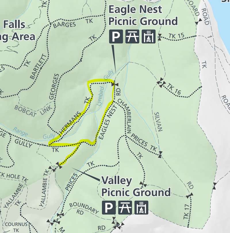
The walk route is:
- The walk begins at Valley Picnic Ground, which is accessed from Boundary Road off Silvan Road. When we visited, our navigation program said that we had to walk the last section along Boundary Road rather than drive. Even though there were gates which are locked in the evening, it was possible to drive all the way to Valley Picnic Ground.
- From the car park, walk to the north past a gate and follow Georges Track downhill past Bridge Track to its junction with Eagle Nest Road.
- Turn right onto Eagle Nest Road and continue past a gully with tree ferns to Eagle Nest Picnic Ground, where you can explore the historic picnic area and former lookout site. Ignore the unsigned branch on the right which is Chamberlain Track.
-embed01.jpg)
- From Eagle Nest Picnic Ground, leave on the west side onto Hermans Track and descend through tall Mountain Ash forest. Immediately after leaving the picnic ground, you will cross a bridge across Lyrebird Gully Creek. The boards on the bridge can be very slippery when wet, so be very careful crossing the bridge.
- Continue on Hermans Track which intersects with Georges Track which comes in from the right. Note that signage calls the track Hermon Track while most maps call the track Hermans Track. From now on you stay on Georges Track back to the picnic ground.
- Rifle Range Gully Track later intersects with Georges Track. Ignore this branch and follow Georges Track as it curves to the left (east) and straightens.
-embed02.jpg)
- When you reach the junction of Georges Track and Eagle Nest Road, turn right and follow Georges Track back to Valley Picnic Ground, completing the loop.
Access for Dogs:
Dogs are not permitted.
Photos:
Location
Boundary Road, Olinda 3788 View Map
Web Links
→ Dandenong Ranges National Park (Olinda Area) Map
→ www.parks.vic.gov.au/places-to-see/sites/valley-picnic-ground


