Durham Ox - Serpentine Creek Canoe Trail


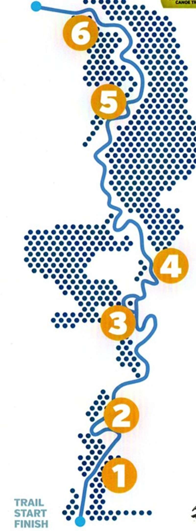
The Serpentine Creek Canoe Trail is a peaceful, self-guided paddling route through the wetlands and farmland of Durham Ox. Six floating yellow trail markers identify places connected with Dja Dja Wurrung culture, early settlement, native wildlife and the creek's continuing role in the surrounding agricultural landscape.
The trail follows approximately five kilometres of slow-flowing and often still water. A purpose-built, all-abilities canoe ramp makes entering the creek easier, although paddlers still require suitable skills, equipment and assistance appropriate to their abilities.
Distance: 5 km interpreted section - allow for the return paddle to the same launching ramp
Route: Out-and-back canoe or kayak trail
Start/Finish: Canoe ramp beside Whytcross Road, Durham Ox
Trail Markers: Six numbered floating buoys
Facilities: All-abilities canoe ramp and toilets at the start/finish area
Trail Markers:
Follow the six floating yellow trail markers to discover the creek's cultural, historical and ecological stories.
1. The Inn
The first marker introduces the former Durham Ox Inn. The original small and humble inn was built in 1848 and was used as a post office and store.
On a hot summer day in 1857, a fire swept across the surrounding land and engulfed the inn. It was rebuilt using approximately 100,000 bricks. The new building contained twelve rooms and a second storey which could be opened into a ballroom.
The inn stood beside the Cobb & Co coaching route. As the nearby railway reduced the importance of Serpentine township, the ballroom became the local council chamber. The former inn is now a private residence and should only be viewed from the creek.
2. Scarred Trees and Ring Tree
For tens of thousands of years, Dja Dja Wurrung Clans were the primary caretakers of this country. Serpentine Creek was an important resource, providing water, food, plants and materials.
Long strips of bark from mature trees were used to make canoes and fishing equipment. Smaller pieces were fashioned into bowls, containers, fishing nets and woven baskets.
Young tree limbs were sometimes shaped into rings. These rings could represent boundary markers or identify places of cultural importance to Dja Dja Wurrung and other Aboriginal groups.
3. Large Canoe Scars
Dja Dja Wurrung canoes were made from long sections of bark and used for fishing and transportation. Large scars from bark removal can still be seen on some mature trees beside the creek.
The bark around these scars has continued to grow, demonstrating how material could be removed while preserving the living tree. The long, stable canoes could carry two or more people and provide a platform for fishing, including fishing at night.
4. Rakali Feeding Platform
The creek's permanent water supports rakali, also known as native water rats, as well as platypuses. These are Australia's only two amphibious mammals capable of living on both land and in water.
Evidence of rakali feeding may include freshwater mussel shells placed in hollows, among exposed tree roots or on partly submerged branches and logs. Rakali are resourceful and intelligent animals, and their presence can indicate a healthy waterway.
Observe wildlife quietly and do not approach, handle or feed any animals.
5. Double Ring Tree
Many of the trees beside the creek are of considerable age and date from before European occupation of the area. Natural hollows have formed in their trunks and branches, providing habitat for birds, bats, reptiles, possums and other animals.
Smaller hollows may be used by parrots, bats and reptiles, while larger hollows can shelter possums and owls.
The double ring tree also demonstrates the deliberate modification of young limbs and branches. Ringed or braided trees can indicate a place of cultural significance.
6. Current Use
The first recorded non-Aboriginal party to cross the creek was led by Major Thomas Mitchell, who described open grassy plains beautifully marked by winding lines of woodland.
European settlers later relied upon the area's natural springs. River red gums, black box and other riparian vegetation continue to follow the winding creek across the rich, black, self-mulching floodplains.
The fertile soils now support mixed farming, livestock and cropping. Near the turning point is the Pennyroyal outfall regulator wall, part of the infrastructure used to control water flows and regulate pumps and other water-management devices.
Look for birds, fish and other aquatic wildlife during the return journey. Animals may be concealed in the treetops, grassy banks and partly submerged vegetation.
Before You Paddle:
Tell someone your planned route and expected return time. Carry enough drinking water, food, sun protection and suitable clothing to remain self-sufficient for up to six hours.
Check the weather forecast, Fire Danger Rating, water conditions and any blue-green algae alerts before leaving.
Recommended safety equipment includes:
- An approved lifejacket or personal flotation device with a whistle attached
- A waterproof trail map or GPS device
- A waterproofed mobile phone
- A hat, sunscreen and protective clothing
- Fixed footwear suitable for water, steep banks and exploring beside the creek
- A first aid kit
- At least one spare paddle for the group
- Fixed buoyancy in every craft
On the Creek:
Avoid paddling alone. Serpentine Creek contains submerged timber, stumps and other debris. Never jump, dive or deliberately capsize your craft into the murky water.
If you capsize, hold onto your buoyancy aid and swim carefully towards the bank.
Summer temperatures can be very high. Avoid overheating by paddling during the cooler hours of the day.
Snakes may be seen basking on logs, resting along the creek bank or swimming across the water during warmer weather. This is their natural habitat. Give them plenty of space and do not interfere with them.
In an Emergency:
Mobile phone reception is reported along the trail, but your phone should be waterproofed and reception should not be relied upon as the only means of communication.
In an emergency, telephone 000 or 112. State that you are on Serpentine Creek beside Whytcross Road at Durham Ox, Victoria. The nearest major road junction is Boort-Pyramid Road. Provide an estimate of how far north you have paddled from the junction and which side of the creek you are on.
Minimum Impact:
Take everything home that you bring onto the creek. Use the designated launching facilities and do not disturb native plants or animals.
Do not touch, climb or damage scarred trees, ring trees or other cultural heritage places. Do not interfere with gates, fences or livestock on surrounding farmland. Fires must not be lit.
A Victorian Recreational Fishing Licence may be required if you intend to fish.
Opening Hours:
The trail is outdoors and has no formal opening hours. Paddle during daylight hours and only when weather, fire and water conditions are suitable.
Cost:
Access to the trail is free. Paddlers need to bring or arrange their own canoe or kayak and safety equipment.
Location:
Canoe launching ramp, Whytcross Road, off Boort-Pyramid Road, Durham Ox VIC 3576
Coordinates: -36.1199211, 143.9177337
Location
Whytcross Road, Durham Ox 3576 View Map
Web Links
→ www.bendigoregion.com.au/visit-loddon-valley/serpentine-creek-canoe-trail


